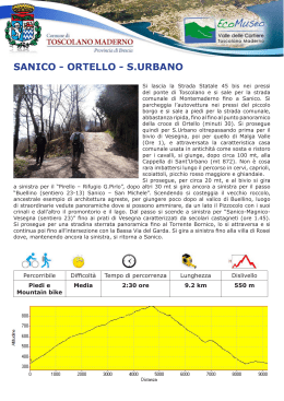
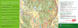
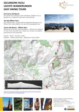
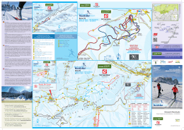
RIFUGIO CAMPEI DE SIMA
Da Maernì di Sotto si prende a destra per il
sentiero 2.7 fino alla PUNTESELA sul Torrente
Campei.
Si gira a destra si fa il percorso dei cùei (ben
segnato con bacheca) che si ricongiunge in
località Persinic con l’itinerario per Campei.
Se si prosegue diritti si sale per la strada carrabile
2.7 fino al bivio di Campiglio di Fondo (ore 0:30)
si passa oltre la sbarra e si prosegue per la
malga Campiglio di Fondo dove si ricongiunge al
sentiero PERSENIC dei Cùei alla fontana d’acqua.
Si sale per il sentiero 22 fino al bivio, girando a
destra si può visitare la grotta “El bus del luf”
ricca di grosse stalagmiti, girando a sinistra
invece si giunge al rifugio di Campei di Sopra.
Dal rifugio si scende a sinistra per il sentiero n 3,
dopo la sbarra si tiene la destra e si sale per il passo della FOBIOLA – SPINO (vecchio manufatto
con trincea della seconda linea della grande guerra).
Al passo si ridiscende a sinistra per Selva Scura – ponte Rilo 692m s.l.m. (h 0,45) e si prosegue a
destra fino alla Puntesela e al punto di partenza di Maina.
Percorribile
Difficoltà
Tempo di percorrenza
Lunghezza
Dislivello
Mountain
bike
Media
3 ore
7.5 km
400 m
BERGHÜTTE „CAMPEI DE SIMA“
Gleich nach der Brücke von Toscolano biegen Sie
nach links in Richtung Gaino ab. Sie fahren in das
Toscolano – Tal hinein und folgen den Schildern
nach Maernì. Von Maernì di Sotto (Unteres
Maernì) fahren Sie nach rechts bis zum Ortsteil
„Puntesela“ am Wildbach „Campei“. Hier können
Sie das Auto parken. Biegen Sie rechts ab auf
den Weg „dei cûei“, der auf der Wanderkarte am
Anschlagebrett gut markiert ist. Dieser Weg trifft
bei „Persinic“ auf den zur Berghütte „Campei“.
Wenn Sie geradeaus auf der Asphaltstraße Nr.27
weitergehen, kommen Sie zur Abzweigung, die
nach „Campiglio di Fondo“ führt (0,30 Min.).
An der Schranke gehen Sie weiter in Richtung
„Campiglio di Fondo“, bis Sie zum Brunnen
kommen. Hier treffen die beiden Wege („Persinic
dei Cuei“ und „Campiglio di Fondo“) wieder zusammen. Gehen Sie weiter auf dem Weg Nr.22
hinauf bis zur ersten Abzweigung. Wenn Sie nach rechts abbiegen, können Sie die Grotte „El bus
del luf“ (Wolfsloch) besuchen, die reich an großen Stalagmiten ist. Wenn Sie dagegen nach links
abbiegen, erreichen Sie die Berghütte „Campei di Sopra“. Hier nehmen Sie den Weg Nr. 3 und,
nach der Schranke, halten Sie sich rechts und gehen hinauf bis zum Pass „Fobiola-Spino“ (hier
ist noch ein Schützengraben aus dem Ersten Weltkrieg zu sehen). Am Pass gehen Sie links in
Richtung „Selva Scura-Ponte Rilo“ (692 m ü.d.M.). Hier nehmen Sie den Weg rechts, der Sie nach
„Puntesela“ und zum Ausgangspunkt nach Maina hinunterführt.
Weg
Schwierigkeit
Laufzeit
Länge
Höhenunterschied
MBT
Mittel
3h
7.5 km
400 m
RIFUGIO CAMPEI DE SIMA
From Maernì di Sotto take the path signed 2.7 on
the right as far as the Puntesela on the Campei
stream. Turn right and follow the route of the
“cùei” (well signed) which joins the route to
Campei at Persinic.
If you continue straight on you go up the carriage
road 2.7 as far as the fork to Campiglio di Fondo
(30 minutes), go past the bar and continue to
the shepherd’s hut Campiglio di Fondo where the
path joins the path PERSENIC dei Cùei at the
fountain.
Go up the path 22 as far as the fork. If you turn
right you can visit the cave “El bus del luf” and
see its impressive stalagmites, while if you turn
left you reach the Alpine hut Campei di Sopra.
From there you go downhill along the path no.3.
Keep to the right past the bar and climb to the pass Fobiola – Spino (remains with a First World
War trench). When you reach the pass make your way back downhill to Selva Scura – Ponte Rilo
(692 mts.a.s.l. - 45 minutes) and continue to the right as far as the Puntesela and back to your
starting point at Maina.
Viable by
Difficulty
Avarange time
Length
Drop
MTB
Mid
3h
7.5 km
400 m
Passo Fobbiola
Rif Campei di Cima
W2
Grotta bus del luf
Bivio sx
compatibile GPS coordinate UTM
W1
Campei di Mezzo
Scaricare