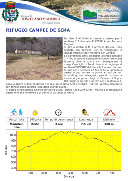
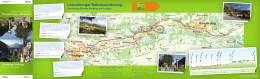
SANICO - ORTELLO - S.URBANO
Si lascia la Strada Statale 45 bis nei pressi
del ponte di Toscolano e si sale per la strada
comunale di Montemaderno fino a Sanico. Si
parcheggia l’autovettura nei pressi del piccolo
borgo e si sale a piedi per la strada comunale,
abbastanza ripida, fino al fino al punto panoramico
della croce di Ortello (minuti 30). Si prosegue
quindi per S.Urbano oltrepassando prima per il
bivio di Vesegna, poi per quello di Malga Valle
(Ore 1), e attraversata la caratteristica casa
comunale usata in antichità come sosta e ristoro
per i cavalli, si giunge, dopo circa 100 mt, alla
Cappella di Sant’Urbano (mt 872). Non è cosa
rara imbattersi lungo il percorso in cervi, caprioli,
scoiattoli, picchio rosso maggiore e ghiandaie.
Si prosegue, per circa 20 mt, e al bivio si gira
a sinistra per il “Pirello – Rifugio G.Pirlo”, dopo altri 30 mt si gira ancora a sinistra per il passo
“Buellino (sentiero 23-13) Sanico – San Michele”. Scendendo si costeggia il vecchio roccolo,
ancestrale esempio di architettura agreste, per giungere poco dopo al valico di Buellino, luogo
di straordinarie vedute panoramiche dove si possono ammirare, da un lato il Pizzocolo con i suoi
crinali e dall’altro il promontorio e il lago. Dal passo si scende a sinistra per “Sanico-MagnicoVesegna (sentiero 23)” fino ai prati di Vesegna caratterizzati da secolari castagneti (ore 1.45).
Si prosegue per una stradina sterrata panoramica fino al Torrente Bornico, lo si attraversa e si
continua poi fino all’intersezione con la Bassa Via del Garda. Si gira a sinistra fino alla villa di Rosei
dove, mantenendo ancora la sinistra, si ritorna a Sanico.
Percorribile
Difficoltà
Tempo di percorrenza
Lunghezza
Dislivello
Piedi e
Mountain bike
Media
2:30 ore
9.2 km
550 m
SANICO - ORTELLO - S.URBANO
Sie verlassen die Hauptstraße 45bis gleich vor
der Brücke von Toscolano und biegen nach links
auf
der
Gemeindestraße
in
Richtung
Montemaderno - Sanico ab. Parken Sie das
Auto in Sanico und gehen Sie auf der steilen
Gemeindestraße hinauf bis zur Panoramastelle
„Croce di Ortello“ (Laufzeit: 30 min). Von hier
gehen Sie nach S.Urbano weiter. Auf dem Weg
finden Sie zuerst die Abzweigung nach Vesegna,
dann die zur „Malga Valle“ (Laufzeit : 1 Stunde). Sie
gehen an dem charakteristischen Gemeindehaus
vorbei, das einst als Pferderaststätte diente,
und kommen, nach ca.100 m, zur „Cappella di
Sant’Urbano ( 872 ü. M.). Es ist nicht selten,
Hirsche, Rehe, Eichhörnchen, Eichelhäher und
den Buntspecht auf dem Weg zu treffen. Gehen
Sie ca. 20 m weiter und an der nächsten Abzweigung biegen Sie nach links ab, hinunter zum
Pass „Buellino – Sanico – San Michele“ (markierter Weg 23-13). Auf dem Weg gehen Sie an
einem alten „Roccolo“ (Vögelfalle) – das ist ein Urbeispiel der Landarchitektur - vorbei und kurz
danach kommen Sie zum Pass „Buellino“, einem an außergewöhnlichen Aussichtspunkten reichen
Ort. Von hier können Sie auf einer Seite den Berg Pizzocolo und seine Kämme , auf der anderen
Seite Toscolano und den See bewundern. Vom Pass gehen Sie links auf dem markierten Weg 23
(Sanico-Magnico-Vesegna) hinunter bis zu den Wiesen von Vesegna, die durch jahrhundertealte
Kastanienwälder charakterisiert sind (Laufzeit : 1,45 Stunde). Von hier gehen Sie auf einer kleinen
Schotterstraße bis zum Wildbach „Bornico“ weiter. Überqueren Sie diesen und gehen Sie weiter,
bis Sie auf den Weg „Bassa Via del Garda“ treffen. Hier biegen Sie nach links ab,bis zur „Villa di
Rosei“. Halten Sie sich dann weiter links bis Sanico.
Weg
Schwierigkeit
Laufzeit
Länge
Höhenunterschied
zu Fuß & MBT
Mittel
2:30 h
9.2 km
550 m
SANICO - ORTELLO - S.URBANO
Leave the main road SS45 bis at the bridge of
Toscolano and drive up the the council road to
Montemaderno as far as Sanico. Park outside
the hamlet and continue on foot along the steep
council road until you get to the viewpoint of the
cross of Ortello (30 mins.). Walk on to S.Urbano:
you will go past the crossroads to Vesegna, the
one to Malga Valle (1 hour) and then the building
which was used in old times to rest horses . After
about 100 mt. you reach the Chapel of S.Urbano
(872 mt.). You may come across deers, roe
deers, squirrels, jays and pied woodpeckers
on the way. Continue for about 20 mt. and at
the fork turn left to the “Pirello – Rifugio Pirlo”.
After another 30 mt. turn left again to the pass
“Buellino (path 23-13) Sanico – San Michele”.
On your way downhill you pass a typical ancient rural building and then you reach the pass of
the Buellino, which offers stunning panoramic views of the ridges of Mount Pizzoccolo on one side
and of the promontory and the lake on the other side. From there go down to the left to “Sanico
– Magnico-Vesegna” (path 23) until you get to the century-old chestnut woods of Vesegna (1.45
hrs.). Continue along a panoramic dirt lane as far as the stream Bornico, cross it and proceed to
the junction with the Bassa Via del Garda. Turn left and continue to the villa of Rosei. Once there,
keep to the left and make your way back to Sanico.
Viable by
Difficulty
Avarange time
Length
Drop
foot & MTB
Mid
2:30 h
9.2 km
550 m
S.Urbano
Vesegna
Bivio sentiero 11
Bivio Vesegna
Bivio sentiero 23-18
Sanico
Rosei
Croce di Ortello
Bivio sentiero 27
Santella
compatibile GPS coordinate UTM
Scaricare