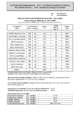
UFFICIO METEOROLOGICO - BTN - STAZIONE MARIO ZUCCHELLI
WEATHER OFFICE - TNB - MARIO ZUCCHELLI STATION
Alla
Al
Sala Operativa
Capo Spedizione
BOLLETTINO METEOROLOGICO DEL 11/12/2006
Meteorological Bullettin of 11th December 2006
Osservazioni delle ore 09:00 locali - Weather observations at 09:00 L.T.
STAZIONE
(Site)
VENTO/Wind
Dir (°) / int (kts)
TEMP.
°C
UMID.
RELAT.
RH %
PRESS.
hPa
ENEIDE (Baia Terra Nova)
360
7
-4.1
95
979
ALESSANDRA (Cape King)
150
1
-5.1
80
971
LOLA (Tourmaline Plateau)
070
1
-16.5
51
802
ARELIS (Cape Ross)
330
12
-5.1
80
970
RITA (Enigma Lake)
020
2
-5.4
69
958
SOFIA_B (David Glacier)
210
12
-19.8
56
809
ZORAIDA (Medio Priestley)
310
23
-12.0
64
883
MODESTA (Alto Priestley)
270
6
-21.1
78
765
SILVIA (Cape Phillips)
230
7
-8.4
87
924
WILLIE FIELD (McMurdo)
360
5
-4.6
---
981
MANUELA (Inex. Island)
300
10
-8.0
50
980
GIULIA (Mid Point)
280
3
-30.0
52
753
IRENE (Sitry Point)
130
5
-26.3
74
----
CONCORDIA - DOME C
230
3
-41.7
59
642
PAOLA - TALOS DOME
160
7
-25.9
76
725
INFORMAZIONI DI CARATTERE AERONAUTICO: (orario GMT)
AERONAUTICAL BULLETTINS AND FORECAST: (GMT time)
NZTB 102000Z (110900L) 35004KT 9999 SCT025 BKN050 M05/M05 A2925 SDG/HDF RMK
BKN SLP906 GRID15004KT B02003KT C09007KT=
NZTB TAF 101812Z (110701L) 04010KT 8000 VCFG BKN025 BKN080 BECMG 101923Z
(110812L) 33012KT 9999 SCT050 SCT100 TEMPO 110609Z (111922L) 09008KT 5000 VCFG
FEW010 BKN060=
Temperatura di windchill a Terra Nova alle ore 09:00 locali: - 10 °C
Windchill temperature in Terra Nova at 09:00 local time:
- 10 °C
Dati Statistici di ieri 10/12/2006
Temperatura Massima
(ore
Temperatura Minima
(ore
Umidità Minima
(ore
Umidità Massima
(ore
Vento Massimo Dir./Int. (ore
00:00L)
23:00L)
00:00L)
06:00L)
03:00L)
-2.1 °C
- 5.3 °C
70 %
100 %
220 ° 23 nodi con picco di 28 nodi
1
Situazione Sinottica: La proiezione di un promontorio
mobile dalla Terra di Adelia verso il settore settentrionale del
Victoria Land, determina l’ulteriore spostamento verso est
della depressione presente sul settore centrale del Mare di
Ross; di conseguenza la nuvolosità della perturbazione cha
ha interessato il settore centrale del Victoria Land tende
progressivamente a dissolversi. L’immagine del satellite F12
(DMSP OLS visibile) mostra una diffusa nuvolosità
stratiforme associata a deboli precipitazioni e nebbie
avvettive, sulle zone marine e costiere tra la Wood Bay e
Cape Adare. Una nuvolosità stratiforme in banchi, associata
a nebbie, è presente sulle zone interne del Plateau, tra il
Reeves Nevè, gli Outback Nunatacks, Talos Dome e Sitry
Point.
Synoptic situation: A mobile ridge of high pressure is
extending towards the northern Victoria Land pushing
further eastward the deep low pressure system on the central
Ross Sea, that has been affecting during the last 24hours the
central Victoria Land; as a result the widespread layered
cloudiness of the frontal system associated to this low
pressure, though gradually, is about to disappear. The
satellite picture above (DMSP- F12 ols sensor, visible
channel) shows the widespread low and mid levels layered
cloudiness with light snowfalls and advection fog patches,
still affecting the coastal areas between the Wood Bay and
Cape Adare. Few patches of layered clouds and fog are still
affecting the inner zones of the Plateau between the Reeves
Nevè, the Outback Nunatacks, Talos Dome neighbours and
Sitry Point.
BAIA TERRA NOVA
MC MURDO AREA
•
•
Italiano: Inizialmente molto nuvoloso per nubi stratiformi nei medi e alti livelli della
troposfera con residui addensamenti e nebbie in banchi sulle zone costiere tra Cape
Washington e Kay Island, ma con tendenza a progressiva diminuzione della nuvolosità
nelle ore centrali della giornata e schiarite sempre piu’ ampie. Venti deboli
settentrionali. Visibilità e definizioni discrete ma in progressivo miglioramento.
English: starting broken by mid and high levels clouds with few patches of low clouds
and fog affecting the coastal areas between Cape Washington and Kay Island; gradual
improvement with cloudiness starting to disappear and ceiling lifting up during the
central part of the day. Light northern wind. Both visibility and definitions fair
becoming good.
Italiano: molto nuvoloso per nubi stratificate a differenti livelli con deboli
precipitazioni in serata; venti deboli o moderati orientali. Visibilità e definizioni buone,
in diminuzione in serata durante le precipitazioni e per nebbie avvettive, in banchi.
English:. Broken to overcast by layered clouds at different levels with light snowfalls by
the evening. Both visibility and definitions good, becoming fair to poor by the evening
due to light snowfalls and advection fog.
Tendenza per le prossime 24 ore (Area di BTN): sereno o poco nuvoloso per nubi alte e sottili, venti deboli
settentrionali, visibilità e definizioni buone.
Outlook for the next 24 hours (TNB Area): flying weather conditions due to few to scattered by high thin
clouds, light northern winds, both visibility and definitions good.
The Forecaster
Lt. Col Angelo ROMITO
2
Scaricare