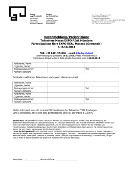
Sasso Rosso
Rocca Piana
C. Palù
Ago di Nardis
Ada
m
Frerone
M. Càdria
Cima Marese
6
M. Altissimo
di Nago
MORI
a
BRETÒNICO
Cima Palòn
2235
d
22
r
do
23 AVIO
Bal
a
24
g
M.
i
Lessini
RECOARO
VALDAGNO
l
FERRARA DI
M. BALDO
M.
V
a
CAPRINO
VERONESE
A22
d
L a g
o
BRENZONE
ROVERETO
21
S. VALENTINO
MALCESINE
G
a
Parco Regionale
dell’Alto Garda
GARGNANO
M. Alberelli
1a 1b
20
CHIENIS
LÒPPIO
2
LIMONE
SUL
GARDA
P. Molvina
M. Zenone
7
TORBOLE
4
17
VIOTTE
M. Marzola
PIETRAMURATA
GARNIGA
L. di Caldonazzo
TERME
Cornetto
Doss
ALDENO
d’Abramo 19
M. Cimon
DRENA
18
RIVA DEL RONZO
Lago di Ledro
TRENTO
M. Stivo
ARCO
5 GARDA
3
SALÒ
DRÒ 9
M. Misone
8
TIARNO
DI SOPRA
GARDONE
e
M. Brento
Cima Palone
VEZZANO
SARCHE
11
10
Caverdina
TOSCOLANO
13
M. Casale
M. Corona
Corna Zeno
S. LORENZO
IN BANALE
SAONE
TIONE
Mattoni
L. di Molveno
PREORE
LAVIS
r i
n a
12
u
CEMBRA
Fium
pp
S a rca
M. Re di Castello
Grotta Rossa
A
o
o
ell
Gr
M. Carè Alto
SALORNO
di
P.zo Gallino
L a
Adamello
MEZZO
14 CADINO
LOMBARDO
16
M. Corona
MEZZOCORONA
ge
M. Mandrone
C. Presanella
l Indice / Inhalt / Contents
ROVERÈ 15
DELLA LUNA
C. di Val Scura
di B
renta
la Presanella
MADONNA DI
CAMPIGLIO
FERRATA
PERCORSO ALPINISTICO
SIRMIONE
DESENZANO
VERONA
A4
INDICE / INHALT / CONTENTS
• PREFAZIONE / VORWORT / PREFACE
4
• INTRODUZIONE / EINLEITUNG / INTRODUCTION
6
• L’ALTO GARDA / DER NORDEN DES GARDASEE/ UPPER LAKE GARDA 10
Inquadramento geografico / Geografische Lage / Geographic situation 10
Geologia /Geologie / Geology
14
Aspetti ecologici e naturalistici / Naturwissenschaftliche und ökologische Aspekte / 16
Ecological and Naturalistic Aspects • BIBLIOGRAFIA22
• 10 REGOLE E CONSIGLI / 10 REGELN UND TIPPS / 10 RULES AND TIPS
24
• SCALA DELLE DIFFICOLTÀ / SCHWIERIGKEITSGRADE / GRADING SYSTEM
26
• INTERVISTA AL SOCCORSO ALPINO DI RIVA DEL GARDA /
30
INTERVIEW MIT DER BERGRETTUNG VON RIVA / MOUNTAIN RESCUE INTERVIEW
• ARCO DI TRENTO
34
• RINGRAZIAMENTI34
001a • Spigolo della Bandiera - Monte Spino
001b • Ferrata Ernesto-Franco - Monte Spino
002 • Il Tracciolino - Percorso Alpinistico al Dos de Cala
003 • Sentiero Attrezzato Mora-Pellegrini - Monte Corno
004 • Ferrata Susatti e Cima Rocca - Cima Capi e Cima Rocca
005 • Ferrata dell’Amicizia o del Centenario - La Rocchetta
006 • Via del 92° Congresso - Monte Baone
007 • Ferrata del Colodri - Monte Colodri
008 • Sentiero Attrezzato degli Scaloni - Coste dell’Anglone
009 • Ferrata Rio Sallagoni - Castel Drena
010 • Percorso Alpinistico delle Lastiele - Coste Massampia
011 • Ferrata Che Guevara - Monte Casale
012 • Sentiero Artpinistico - Croz delle Niere
013 • Ferrata Rino Pisetta - Monte Garzolet
014 • Ferrata Burrone Giovannelli - Cime di Vigo
015 • Ferrata Favogna - Cime di Vigo
016 • Ferrata Rio Secco - Monti di Cembra
017 • Ferrata Giordano Bertotti - Monte Chegul
018 • Sentiero Attrezzato delle Stel - Coste di Gazzo
019 • Ferrata Giulio Segata - Dosso d’Abramo
020 • Ferrata del Somator - Monte Biaena
021 • Ferrata Monte Albano
022 • Sentiero Attrezzato delle Vipere - Cima Corna Piana
023 • Ferrata Gerardo Sega - Monte Coalaz
024 • Ferrata delle Taccole - Coal Santo
37
43
51
61
67
81
91
97
105
113
121
127
137
143
155
165
173
181
187
193
203
209
219
225
233
9
Monte Bondone-Stivo l Ferrata Giulio Segata
FERRATA GIULIO SEGATA
Dosso d’Abramo
Ferrata alternativa
Via di fuga
Attacco
Dislivello tot. salita: 500 m
Dislivello in ferrata: 73 m
Difficoltà: II 5
Esposizione: est, sud-est
Tempi: 4,40 h
Punto d’appoggio:
Capanna Viote T. 0461 948093
[email protected]
chidere se la ferrata è agibile
Gesamthöhenunterschied:
500 m
Höhenunterschied
Klettersteig: 73 m
Schwierigkeit: II 5
Exposition: Ost, Südost
Total ascent: 500 m
Total ascent on ferrata: 73 m
Grade: II 5
Aspect: East, South-East
Duration: 4 h 40
Zeiten: 4,40 h
Cartografia/Karte/Map: Tabacco 055 - 1:25.000
A sinistra:
il foro naturale sulla roccia alla partenza della ferrata
019
193
Monte Bondone-Stivo l Ferrata Giulio Segata
Die Berggruppe des Bondone-Stivo liegt nordöstlich
des Gardasees. Wie der Monte Baldo verläuft auch er
linear von Norden nach Süden mit mehreren Bergspitzen, die über 2000 m hoch sind. Zu den wichtigsten
Gipfeln gehört der Monte Vason, der ursprünglich
der ganzen Bondonegruppe seinen Namen gab, der
Monte Palon, der die Stadt Trento überragt und mit
Skiliften ausgestattet ist, die Roste, die Viote im Westen
einschließt, die drei Gipfel des Bondone, Cima Verde,
Doss d’Abramo und der Monte Cornetto, die im Osten
die Valle dei Laghi abschließen, und schließlich weiter
südlich, der Monte Stivo, der durch seine Höhe (2060
m) und die außergewöhnliche geografische Lage ein
unglaubliches Panorama bietet. Außerdem eignet er
sich für volo libero (Luftsport ohne Motor) und alpinen
Skisport.
In der Mitte der Berggruppe befindet sich ein Tal mit
glazialem Ursprung, die Conca delle Viote, eine weite
Fläche aus Futterweiden und Prärie, auf der 1938 der
gleichnamige Botanische Garten gegründet worden ist
(einer der pflanzenreichsten der Alpen mit mehr als
2000 Pflanzen- und Blumenarten, die aus den zentralen Bergketten der Welt stammen).
Wegen seiner strategischen Position mit Übersicht über
das Val Lagarina im Osten und über das Valle dei Laghi
im Westen wurde der Bondone von österreichischen
Truppen besetzt, noch heute sind die steinernen Reste
der Kasernen erkennbar.
Der Klettersteig ist gewagt und einer der schwierigsten
des Trentino. Es handelt sich um eine senkrechte Wand
mit sehr wenigen Tritten, mit Eisenausrüstung „gezähmt“, ohne welche wohl auch Spitzenkletterer nicht
aufsteigen könnten. Die Route ist kurz aber intensiv, auf
der Hälfte der Strecke, dem mittleren Felsband, findet
man einen gesicherten Fluchtweg, der sich in mehrere
Richtungen verzweigt. Eine Abzweigung führt zur Spitze, die andere auf den Bergsattel zwischen dem Doss
d’Abramo und der Cima Verde. Der Klettersteig ist sehr
empfehlenswert, auch wegen der beiden charakteristischen Passagen durch natürliche Löcher an der Wand.
Es war 1979 als sich jeden Sonntag um drei Uhr morgens eine Gruppe von 7 bis 8 Freunden aus Sopra-
The Bondone-Stivo group is located to the north-east of Lake Garda. Like the Baldo group, this
runs from north to south with numerous peaks
over 2000m. Among the most important are
Monte Vason, which originally gave its name to
the whole Bondone region, Monte Palon, a ski
resort which overlooks the city of Trento, la Rosta
which borders the Viote to the west, the three peaks of Bondone, Cima Verde and Doss d’Abramo,
which together with Monte Cornetto lie to the east
of the Valle dei Laghi, and finally Monte Stivo, the
furthest south which at an altitude of 2060m offers a genuinely breathtaking and unique view,
as well as being a popular spot for paragliding
and ski-touring.
At the centre of the group there is a glacial valley
known as the Viote basin, a wide area of pastures and meadows. In 1938, the alpine botanical
garden of the same name was opened here. It is
now one of the richest gardens in terms of fauna
throughout the Alps, home to over 2000 plans
and flowers originating from the world’s main
mountain ranges. Because of its strategically advantageous position over the Val Lagarina to the
east and the Valle dei Laghi to the west, Austrian
troops were stationed in the Bondone and there
are numerous stone war remains in the area.
This is a challenging route and is one of the
hardest in Trentino. It tackles a vertical face with
very few holds and is climbable only thanks to
the cable, without which even the most proficient climbers would fail to climb it. The route is
short but intense: half-way through on the ledge
at half-height there is a protected escape route,
which forks to lead to the summit or to the saddle
between the Doss d’Abramo and Cima Verde. An
unmissable route, with two characteristic sections
195
Monte Bondone-Stivo l Ferrata Giulio Segata
monte trafen, zwischen 20 und 35 Jahre alt, bereit die
Gipfel des Trentino zu erobern. Um fünf Uhr morgens,
egal wohin es gehen sollte, mussten die Schuhe angeschnürt und der Rucksack auf dem Rücken sein. Es war
fast eine Frage des Prinzips und mit diesem Gedanken
konnte diese kleine Gruppe von Freunden, ohne dass
sie Vereinen oder Berggruppen angehört hätten, Sonntag für Sonntag neue Erfolge für sich verbuchen. Mehrmals änderten sie im Laufe des Jahres den Ort, an dem
sie einen Klettersteig errichten wollten, bis der Doss
d’Abramo zum Objekt ihres kühnen Projektes wurde.
Sie transportierten alles per Hand, auch den Generator. Die Arbeit in der Gruppe war hart. Die Stärksten
übernahmen die Bohrarbeiten, dabei litten sie unter
der Kälte; vor allem im Innern der beiden natürlichen
Felslöcher. Die anderen Freunde reichten das Material
und hielten Stützseile gespannt, die wie in einem Netz
den Bohrenden an der überhängenden Wand hielten.
Und dann der Marsch vom Klettersteig ins Tal, wenn
das Werkzeug kaputt ging und man dort versuchte,
es zu reparieren. 1982 beendeten die sieben Freunde
ihre Arbeit. Der Klettersteig wurde nach Giulio Segata
benannt, dem Onkel von zwei Gruppenmitgliedern, der
in jungen Jahren nach einem Skirennen an einer Lungenentzündung verstorben war.
ANFAHRT 1
Von Arco entlang der SS45bis in Richtung Trento. Auf
der Höhe von Dro nach rechts in Richtung Drena, Cavedine und Lasino weiterfahren. In Lasino geht es weiter in Richtung Lagolo Bondone bis zur Ortschaft Viote.
Gegenüber der Hütte parken 1547 m, N46°01’13.3” E
011°02’32.9”.
ANFAHRT 2
Von Viote (Anfahrt 1) hinunter in Richtung Cimone,
Aldeno und Rovereto fahren. Nach ca. 1,5 km rechts
eine Schotterstraße mit Wegschild Nr. 636 nehmen, bis
zu einer Schranke an der man parkt. Auf der rechten
Seite gibt es eine Picknick-Zone 1528 m, N 46°00‘48.6”
E011°03‘05.1”.
ZUSTIEG 1
Man muss Richtung Süden über die Wiesen der Conca
delle Viote gehen, am Weg Nr. 607 dem Kamm folgen
und dabei den Cornetto, den westlichsten Gipfel, an-
in the natural ravines in the face. In 1979, a group
of friends in their early twenties from Sopramonte were up at 3am every Sunday to conquer the
Trentino peaks. At five in the morning, wherever
they were headed they needed their boots and
rucksacks on. It was a matter of principle and
spirit. Although not part of any alpine society or
club, this little group went out week after week,
with great success. During this year the construction of the ferrata caused them to change their
plans, and so the Doss d’Abramo became their
next project. They carried everything up by hand,
generator included. It was hard work though; the
strongest among them drilled, suffering from the
frost particularly in the two natural gorges, whilst
their companions passed them materials and
kept the wires taut so that the bolter could be
close to the overhanging face. Then there were
the trips back to the village for repairs when their
equipment broke... Young, strong and motivated,
the seven friends completed the work in 1982. On
the suggestion of one of the group, the ferrata
was dedicated to Giulio Segata, an uncle of two
members of the group who sadly of pneumonia
at a young age after a skiing expedition.
ACCESS 1
From Arco take the SS45bis towards Trento. At
Dro, follow signs right for Drena, Cavedine, Lasino. At Lasino, continue towards the Lagolo Bondone to reach Viote. Park in front of the rifugio.
1547m, N46°01’13.3” E 011°02’32.9”.
ACCESS 2
From Viote (see Access 1) descend towards Cimone, Aldeno, Rovereto. After 1.5km take a dirt
road on the right, marked 636, until a forestry barrier. Park here on the right by a picnic area. 1528m,
N 46°00’48.6” E011°03’05.1”.
197
Scarica