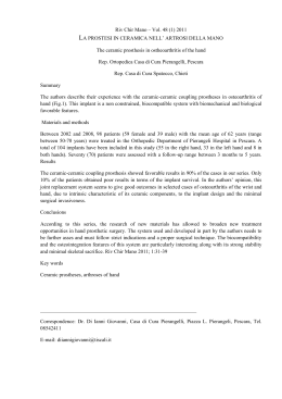
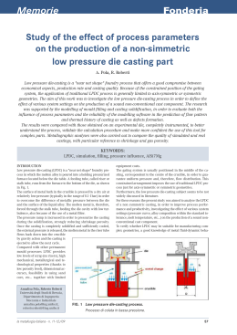
ANNALS OF GEOPHYSICS, VOL. 46, N. 5, October 2003
An inventory of river anomalies
in the Po Plain, Northern Italy: evidence
for active blind thrust faulting
Pierfrancesco Burrato, Francesca Ciucci and Gianluca Valensise
Istituto Nazionale di Geofisica e Vulcanologia, Roma, Italy
Abstract
The Po Plain is a low-relief area characterised by active shortening accommodated by blind thrust faulting. In
this almost flat region depositional rates are similar to tectonic rates and deformation is seldom expressed by
noticeable surface anticlines. We adopted a geomorphological approach based on the detailed analysis of the
drainage network to identify the location of active thrust faults. A total of 36 anomalies represented by sudden
river diversions and shifts in channel pattern were accurately mapped. After comparison with the location of subsurface buried anticlines and of historical seismicity, these anomalies could be related to a tectonic origin and
included in a database. Their distribution highlights the activity of the buried outer thrust fronts of both the
Southern Alps and the Northern Apennines. Among all the anomalies, we identified one related to the seismogenic source responsible for the 12 May 1802 earthquake (Me 5.7), which struck the Oglio River Valley near
Soncino (Cremona). We propose that this earthquake was generated by an east-west trending, north-dipping,
blind thrust fault that roots into the Alpine system. If this inference is correct, other faults along the Southern
Alpine margin are potentially seismogenic.
striking example is the Los Angeles basin in
California, located at the transform Pacific
margin of the North American plate (Wright,
1991). Here more than 12 million people live
in an area prone to destructive though moderate earthquakes generated by blind or elusive
thrusts (e.g., Hauksson et al., 1988; Dolan
et al., 1995; Shaw and Suppe, 1996). Given the
hidden nature of these seismogenic faults and
related structures, they have been traditionally
explored only by means of indirect methods
such as interpretation of growth strata (e.g.,
Suppe et al., 1992), geodesy (e.g., Lin and
Stein, 1989; Massonet et al., 1993) and morphotectonic studies (e.g., Bullard and Lettis,
1993).
The aim of this work is to present a geomorphological method for the identification of blind
active faults associated with subdued topographic
expression. We focused on the Po Plain, a lowrelief sedimentary basin intensely deformed by
Key words tectonic geomorphology – drainage
anomaly – blind thrust – Po Plain – 1802 Oglio Valley
earthquake
1. Introduction
Alluvial plains are among the most densely
populated areas worldwide. This is the result of
a combination of morphological, hydrological
and geological factors that make them advantageous for human settlements. However, often
they are located in active regions, and their flat
surface resulting from a high sediment supply
from nearby high relief areas may hide blind
faults posing a significant seismic hazard. A
Mailing address: Dr. Pierfrancesco Burrato, Istituto
Nazionale di Geofisica e Vulcanologia, Via di Vigna Murata
605, 00143 Roma, Italy; e-mail: burrato @ingv.it
865
Pierfrancesco Burrato, Francesca Ciucci and Gianluca Valensise
buried folds and thrusts, as revealed by extensive
oil exploration (fig. 1a,b). In spite of the occurrence of historical earthquakes up to magnitude
6.5, the activity of individual tectonic structures is
poorly known. The Po Plain is one of the most
densely populated areas of Italy, has a rich patrimony of old historical towns, and represents the
most important concentration of industrial facili-
Como L.
a
9
8
10
SOUTHERN ALPS
46°
6
OCLINE
30
00
300
Fig. 4
C
0
40
00
. 1b
AR
2
500
0
FERR
A
FOLD RA
S
600
0
700
Parma
0
lve
lla
Vi
Fig
ILIA
4
rn
surface anticline
r
Va
zi-
km
N
Bologna
NIN
b
S
30
0
40
0
50
0
ES
5
100
10°
8°
Ferrara
L.
0
EN
45°
IC
AT
RI LDS
AD FO
Other faults, mainly reverse
Base of Pliocene
AP
nto
va
Le
Main thrust/reverse faults
20
0
RO
M
FO AGN
LD A
S
ia-
Seismogenic Sources
Venezia
3
1
EM
V
a
MO
N
Torino AFRERRATO
C
Verona
INE HOM
P
TO
E
EN
nz
PEDEALP
Milano
S. Colombano A.
IN
LA
ice
-V
Garda L.
io
Trino Vercellese A.
Montello A.
h
Sc
Iseo L.
Brescia
Pordenone
7
Idro L.
Apennines
outer fronts
Po R. Adda R.
12°
11
Emilia Arc
Southern Alps
outer fronts
N
Oglio R.
0
-5
-10
km
Fig. 1a,b. a) Simplified structural map of the Po Plain and neighbouring Veneto Plain, showing the main tectonic elements (from Pieri and Groppi, 1981, modified), and contours of the base of the Plio-Quaternary sedimentary
sequence (from Bigi et al., 1989). The plain is shaded in light grey, while higher topography regions are shown in
white. The outer thrust fronts of the Southern Alps and of the Apennines are buried beneath the thick syn-orogenic
clastic deposits. The seismogenic sources are from Valensise and Pantosti (2001b) and are identified in table II.
b) Structural cross-section of the Central Po Plain, showing the main buried thrust fronts of the Northern Apennines and Southern Alps (from Cassano et al., 1986, modified). Location of the trace is shown in fig. 1a.
866
An inventory of river anomalies in the Po Plain, Northern Italy: evidence for active blind thrust faulting
9
11.5
Garda L.
en
Br
ta
1802 Valle dell’Oglio earthquake
Iseo L.
R.
Milano
45.5
Verona
da
Ti
ci
no
R.
Venezia
Mincio
Ad
Parma 1971
R.
Og
lio
Pavia
R.
Parma 1983
Adige R.
Po River
Po River
Reggio Emilia 1996
Se
Parma
Ta
n
Ferrara
cch
aro
R.
ia R
.
Alessandria
Reno R.
Reggio Emilia
Bologna
44.5
Genova
Me=6.8
Me=6.5
Me=6.0 0
Me=5.5
N
Km
100
Arno
R.
Firenze
Fig. 2. Historical seismicity of the Po Plain (CPTI, Working Group, 1999). The focal mechanisms of the three
largest instrumental earthquakes recorded in the area are consistent with ongoing N-S contraction. In contrast,
seismicity recorded in the inner portions of the Apennines chain is mainly extensional. Only a few earthquakes
are reported north of the Po River, and seismicity does not follow a regular pattern.
ties country-wide. In contrast with its high vulnerability, it is traditionally considered a region of low
seismic hazard (e.g., Albarello et al., 2000).
Current historical catalogues list very few large
earthquakes in the area and show that most of them
do not exceed Me 5.5 (equivalent magnitude from
CPTI, Working Group, 1999). Most of the seismicity is concentrated south of the Po River along
the Apennine foothills and on some Apennine
outer fronts (fig. 2). Conversely, the seismicity is
more sporadic in time and space north of the Po
River. No significant historical or instrumental
earthquakes are documented west of Milan, except
for a few events in the Monferrato area.
Since even moderate earthquakes can produce extensive damage due to the high exposure of buildings and facilities, the identifica-
tion and characterisation of potential seismogenic sources is crucial for mitigating the seismic risk. To locate the areas undergoing tectonic vertical deformation we adopted a geomorphological approach based on the analysis of
the pattern and behaviour of the fluvial network. Alluvial rivers are very sensitive to modest ground tilting, to which they react with
deflections and changes of their sedimentation
pattern. We believe this approach is especially
promising in areas such as the Po Plain, where
the evolution of the drainage pattern is not
affected by morphological obstacles nor controlled by bedrock heterogeneities. Only two
anticlines are associated with a morphological
expression (fig. 1a,b): the Trino Vercellese
Anticline (Western Po Plain), which has about
867
River
name
Location
of anomaly
1
Po
Montarolo (VC)
2
Sesia
Palestro (VC)
3
Agogna
Vespolate (NO)
4
Agogna
Ottobiano (PV)
5 Lambro/S. Lambro
S. Colombano (LO)
6
Adda
Rivolta d’Adda (BG)
7
Adda
Cornegliano/Cavia (LO)
8
Brembiolo
Casalpusterlengo (LO)
9
Serio
Bariano (BG)
10
Serio
Malpaga (BG)
11
Oglio
Romano di L. (BG)
12
Mella
Poncareale (BS)
13
Mella
Bassano Bresciano (BS)
14
Oglio
Soncino (CR)
15
Mincio
Goito (MN)
16
Mincio
Mantova (MN)
17
Adige
Verona (VR)
18
Adige
Legnago (VR)
19
Po
Ficarolo (RO)
20
Lamone
Alfonsine (RA)
21
Senio
Cotignola (RA)
22
Idice
Budrio (BO)
23
Reno
S. Agostino (BO)
24
Panàro
Bomporto (MO)
25
Panàro
Castelfranco Emilia (MO)
26
Secchia
Mirandola (MO)
27
Po
Guastalla (RE)
28
Crostolo
Reggio Emilia (RE)
29
Enza
Monticelli Terme (PR)
30
Parma
Parma (PR)
31
Arda
Cortemaggiore (PC)
32
Po
Cremona (CR)
33
Nure
S. Polo (PC)
34
Nure
S. Giorgio Piacentino (PC)
35
Trebbia
Maniaco (PC)
36
Tidone
Pontetidone (PC)
Id
57
57/58
58
58
59/60
46
60
60
46
46
46
47
47/61
60/71
62
62
49
63
76
89
88
88
75
75
87
75
74
74/86
73
73
72/73
60
60/72
72
60
60
IGM Sheet
# (1:100 000)
45.18
45.30
45.33
45.14
45.20
45.44
45.31
45.17
45.32
45.54
45.53
45.47
45.35
45.20
45.26
45.17
45.34
45.16
44.91
44.44
44.38
44.53
44.77
44.66
44.79
44.73
45.01
44.70
44.81
44.86
45.01
45.14
45.00
44.93
45.06
45.04
Lat N
8.29
8.52
8.66
8.77
9.48
9.49
9.60
9.65
9.70
9.73
9.86
10.12
10.19
10.29
10.70
10.70
11.26
11.38
11.59
12.06
11.95
11.51
11.35
10.99
11.17
10.99
10.69
10.62
10.44
10.32
9.96
9.92
9.76
9.71
9.64
9.53
Long W
CP/D
D
D
CP
D/CP
CP
CP/D
D
CP
CP
CP/D
CP/D
CP/D
D/CP
D
D
D/CP
CP
D
D/CP
D/CP
D
D
D/CP
CP
D/CP
D/CP
D
CP/D
CP/D
D
CP/D
CP
CP
CP
CP
Anomaly
type
Length
Anomaly
of anomalous
rating
reach
(km)
36.0
A
22.4
B
13.9
C
7.6
C
26.4
A
13.3
B
48.7
A
7.0
C
8.7
C
8.2
C
15.3
A
10.4
B
13.0
A
79.5
A
8.9
B
23.8
A
29.4
A
14.9
C
36.0
B
14.9
A
19.4
A
26.4
B
37.6
A
30.0
A
32.6
A
43.8
A
28.6
A
10.7
C
17.3
A
20.5
A
13.8
B
36.4
A
8.7
C
5.0
C
6.8
C
10.0
C
868
Y
Y
Y
Y
Y
Y
Y
Y
Y
Y
Y
Y
Y
Y
Y
Y
Y
Y
Y
Y
Y
Y
Y
Y
Y
Y
Y
Y
Y
Y
Y
Y
Y
Y
Y
Y
Y
Subsurface Topographic
anticline expression
8.7
0.0
6.5
6.0 - 20.0
1438 6 11 (5.5)
1831 9 11 (5.3)
1832 3 13 (5.5)
1971 7 15 (5.6)
4.6
9.8
0.0
Distance
from
anomaly
(km)
1688 4 11 (5.7)
1688 4 11 (5.7)
1796 10 22 (5.7)
1117 1 3 (6.6)
1802 5 12 (5.6)
1786 4 7 (5.2)
Associated
historical
earthquake(s)
(Me)
High
Medium
Low
Low
High
Low
High
Medium
Medium
Low
High
Medium
High
High
Medium
Medium
Medium
Low
Medium
High
High
Medium
High
High
High
High
High
Medium
High
Medium
High
High
Medium
Low
Medium
Medium
Confidence
of tectonic
origin
Table I. List of the drainage anomalies identified in the Po Plain and positively related to a tectonic origin (ID numbers as in fig. 5). The main types of anomaly that were
recognised are drainage Diversions (D) and Channel Pattern shifts (CP). The rating of the anomalies is based on the length of the anomalous reach, on the type of anomaly, and
in the case of diversions it is also based on the angle of divergence between the mean flow direction and the direction of the maximum topographic gradient (see Section 4 for
details). Higher ratings (A) were assigned to anomalies characterised by longer anomalous reaches and Diversions (D) associated with Channel Pattern shifts (CP). Historical
earthquakes tentatively associated to each anomaly are shown along with minimum epicentral distance from the anomalous reach (Me from CPTI, Working Group, 1999). The
last column lists how much we rely on the tectonic origin of the anomaly, based on all considerations. Anomalies #.28, 29 and 30 occur within 20 km of the epicentral location
of the four historical earthquakes listed in the nearby cell.
Pierfrancesco Burrato, Francesca Ciucci and Gianluca Valensise
An inventory of river anomalies in the Po Plain, Northern Italy: evidence for active blind thrust faulting
40 m of relief and forces the Po River to follow
an anomalous course (anomaly #.1 in table I);
and the San Colombano Anticline (Central Po
Plain), associated with the sharp eastward deflection of the Southern Lambro River (anomaly #5 in table I). We used basic topographic
data (topographic maps and DEM) to identify
anomalous reaches along several alluvial rivers
draining the Po Plain.
In general, anomalies in the drainage pattern
may be ascribed to three main families of causes:
climate, human activity and tectonic activity. Climate changes may induce rivers to cross critical
erosional or depositional threshold values controlling major channel pattern changes (Schumm and
Khan, 1972). Human activities may induce
changes in the fluvial system by direct modifications of the channel (e.g., engineering works and
drainage regulation), by indirect alteration of the
stream discharge and sediment load transport
(Knighton, 1984), or by modifying the stream gradient through ground-water withdrawal. Tectonic
activity produces longitudinal and lateral changes
of the stream gradient, that alone may induce channel pattern shifts and diversions. These tectonic
modifications, however, may accumulate and become apparent only in conjunction with extreme
climatic events altering water discharge and sediment supply.
The anomalies we identified consist in river
diversions, shifts in channel pattern and longitudinal changes of the channel behaviour. Due
to their size, they are suggestive of the presence
of active buried tectonic structures. Their true
origin was assessed by spatial comparison between their location and the pattern of buried
anticlines reported in the geological maps, and
with the historical earthquakes listed in current
catalogues.
We constructed a database of 36 anomalous
reaches along more than 20 rivers. Each anomaly is believed to be evidence of the activity of
a blind thrust (table I). We could discriminate
the seismic versus aseismic behaviour of the
underlying fault only for a few cases where the
anomaly is unambiguously associated with historical or instrumental seismicity.
We present as a case history the application
of this approach to the identification of the
source of the 12 May 1802 earthquake (Me 5.7),
that struck the Oglio River Valley near Soncino
(Cremona).
2. Geologic and geomorphic overview of the
Po Plain
2.1. Tectonic setting
The geologic evolution of the Po Plain reflects the regional convergence between the African and European plates. This sedimentary
basin is located at the northern termination of
the Adria microplate, a promontory of the
African plate. Since Late Cretaceous it represented the foreland of two chains of opposite
vergence generated by the collision between the
African and European plates (e.g., Robertson
and Grasso, 1995): the north-verging Apennines and the south-verging Southern Alps. Thrusting of these two chains loaded and flexed the
Adria continental crust, giving rise to foredeep
basins where a thick syn-orogenic clastic sequence was deposited (Doglioni, 1993, and references therein). As suggested by plate motion
reconstructions (DeMets et al., 1994), and confirmed by seismicity (CPTI, Working Group,
1999) relative motion between the two plates is
ongoing with a convergence in a NNW-SSE direction, that geodesy indicate to have a rate of less
than 1 cm/yr (Ward, 1994; Anzidei et al., 2001).
Part of this deformation is accommodated seismically within the thrust fronts of the two chains.
Due to the fast subsidence rates induced in
the whole Po Plain area by the tectonic loading
of the two chains, the more external fronts of
the two thrust belts are buried beneath the plain.
Therefore the main tectonic elements were mapped by means of the extensive seismic reflection
data used for oil exploration (Pieri and Groppi,
1981). The map of the base of the Plio-Quaternary sequence south of the Po River (Pieri
and Groppi, 1981) shows the occurrence of
three arcs of blind, north-verging thrusts and
folds that define the Apennine thrust fronts
(fig. 1a,b), from west to east: a) the Monferrato
Arc (Elter and Pertusati, 1973); b) the Emilia
Arc, and c) the Ferrara-Romagna Arc. The latter is further subdivided into three relatively minor structures: the Ferrara folds, the
869
Pierfrancesco Burrato, Francesca Ciucci and Gianluca Valensise
Romagna folds and the Adriatic folds. The
Ferrara folds («Dorsale Ferrarese») are the
most external structures of this arc. North of the
Po River, the outer fronts of the Southern Alps
thrust belt are arranged in a more simple pattern
and deform the south-sloping Pedealpine homocline (fig. 1a). The E-W continuity of the
thrust front is interrupted by the Schio-Vicenza
Line, an important transfer structure that separates the Po Plain thrust fronts to the west, from
those of the Veneto Plain, to the east. In spite of
the diffuse folding and thrusting imaged in the
subsurface of the Po Plain by the geophysical
exploration, very few tectonic structures are expressed at the surface. The most noticeable exceptions are represented by the Trino Vercellese Anticline, the San Colombano Anticline
and the Montello Anticline in the Veneto Plain
(from west to east, fig. 1a). The Quaternary
activity of these structures is testified by their
influence on the drainage pattern and by the
presence of young terraced surfaces tilted and
uplifted along their flanks (Ferrarese et al.,
1998; Benedetti et al., 2000; Castiglioni and
Pellegrini, 2001).
During the Tertiary and the Quaternary, a
considerable thickness of sediments was deposited in the Po Valley Basin, on top of a sequence of Mesozoic passive margin carbonatic
rocks. As a whole this clastic sequence is a
regressive succession. Sediment sources included the Southern Alps and Apennines fold and
thrust belts. On the southern side of the Po Plain,
the Plio-Quaternary sediments in the foredeep
are 7-8.5 km thick (Doglioni, 1993). Sediments
in the Southern Alps foredeep, are between 2 and
6 km thick (Doglioni, 1993; Bertotti et al.,
1998).
The most recent large earthquakes of the
region occurred in 1971 and 1983 near Parma
(Ms 5.7 and 5.0, respectively), and in 1996
near Reggio Emilia (Ms 5.1). The focal mechanism of the 1971 Parma event shows a reverse
solution with a large strike-slip component (Anderson and Jackson, 1987). The Centroid Moment Tensor solutions of the 1983 Parma and
1996 Reggio Emilia events (CMT Harvard Catalogue, Dziewonski et al., 1983) show a thrust
solution with a small strike-slip component,
and with P-axis oriented N36°W and N24°W,
respectively. This compressional tectonic regime is confirmed by the analysis of the Reggio
Emilia main shock and related aftershocks
(Selvaggi et al., 2001). The focal mechanisms are
consistent with a N-S sub-horizontal m1.
Similar results were reached by Frepoli and
Amato (1997), who obtained N-S oriented
compressional P-axes using fault plane solutions, and Montone and Mariucci (1999) with
an analysis of borehole breakouts, that show
SHmax oriented perpendicular to the trend of the
thrust fronts. Other recent instrumental earthquakes include the 2000 Reggio Emilia event
(Mw 4.5), the 2000 Faenza-Forlí sequence
(Mw 3.4-4.4), and the 2000 Monferrato event
(Mw 4.6).
2.3. Geomorphology
The Po Plain stretches E-W across northern
Italy for more than 40.000 km2, and is the
widest alluvial basin of the peninsula. It is
delimited both south and north by the topographic highs of the Apennines and of the Alps,
respectively, and to the east by the Adriatic
coastline. The plain is locally up to 100 km
wide, and is drained axially by the 652 km long
Po River. For most of its course the Po is an
alluvial river characterised by a single meandering channel. Its catchment basin is larger
than 70.000 km2.
The Po Plain can be separated into several
Quaternary geomorphological units (MURST,
1997a; Marchetti, 2002, and references therein). The area located between the southern
boundary of the Alps and the Po River is characterised by the presence of a wide low-gradi-
2.2. Seismicity
Most of the earthquakes listed in current
historical catalogues are concentrated south of
the Po River along portions of the pede-Apennines thrust front and on some buried Apennines outer fronts. Earthquakes are more infrequent north of the Po River and west of Milan,
where only background micro-seismicity is recorded (fig. 2).
870
An inventory of river anomalies in the Po Plain, Northern Italy: evidence for active blind thrust faulting
ent, south-sloping depositional surface of fluvio-glacial and fluvial origin. This outwash
plain, locally named «Plain main level» (Livello
fondamentale della pianura in Petrucci and
Tagliavini, 1969), was built up during the last
glaciation, when rivers flowing from the Alps
were characterised by water discharge and sediment supply substantially larger than today
(Marchetti, 1990, 1996). Abandoned paleo-channels seen on top of this surface are oversized
with respect to the present hydrography, implying a change in discharge occurred at the end of
the last glaciation which led to the erosion of
the alluvial plain (Marchetti, 1996). The present
drainage network flows in valleys deeply
incised into the aggradation surface. Small
patches of early to Middle Pleistocene fluvioglacial deposits («old terrace unit», Marchetti
2002), and moraine deposits of PleistoceneHolocene age, near the outlets of the main
alpine valleys, border the Po Plain at the Alps
foothills. South of the Po River the drainage
network flows on top of a Holocene aggradation surface, which merges with the active alluvial plain of the axial Po River. Continuous sedimentation is suggested by buried archaeological artefacts ranging in age from the Neolithic
period to the Middle Ages (Marchetti, 2002).
Close to the Apennine margin this surface is
covered by coalesced alluvial fans of the same
age as the «Plain main level», overlain by older
fans deposited during previous glacial maximums (Marchetti, 2002 and reference therein).
In contrast with the rivers flowing from the
Alps, the Po River and its right tributaries flow
on top of an active alluvial plain.
Antecedence
Dranage piracy
Diversion
Diversion
AN
TIC
LIN
E
SY
NC
LIN
E
Uplift
Erosion
Antecedence
Subsidence
Deposition
Attraction of drainage
Tilting
Uplift
Diversion
Tilting
0
Km
20°
2
4
Growth strata
6
Km
5
10
15
20
Fig. 3. Schematic representation in map view (above) and cross-section (below) of the effects that slip
on a generic blind, low-angle thrust fault may have
on geomorphic/sedimentary processes. The vertical
component of the expected deformation is related to
the fault’s geometry and kinematics through the elastic dislocation theory. Evolution of sedimentation
and drainage pattern over a wide area is controlled by
the growth of the anticline/syncline, which produces
tilting of the ground surface.
sitional behaviour of the drainage network, and
the geometry of any erosional and/or depositional surfaces. The drainage network is especially sensitive to vertical deformation and thus
very useful for analysing low-relief areas, where
few or no landforms constrain the location of
active faults (Holbrook and Schumm, 1999;
Schumm et al., 2000). Field studies and numerical models show that the interaction between
drainage systems and tectonic sources is governed
mainly by the geometry and kinematics of the tectonic source (e.g., Champel et al., 2002) and by
3. Geomorphic indicators of growing
anticlines
Growing anticlines and tilting over a wide
region encompassing an anticline-syncline pair
are the surface expressions of slip on an underlying buried thrust or reverse fault (e.g., Yeats,
1986; Stein and Yeats, 1989) (fig. 3). There are
numerous geological, geomorphic and landscape features that are sensitive to slip on a
buried thrust fault: topography, the thickness
and shape of growth strata, the erosional/depo871
Pierfrancesco Burrato, Francesca Ciucci and Gianluca Valensise
the relative size of the rivers (e.g., Guccione et al.,
2002). Fault characteristics control the pattern
and style of surface deformation, whereas the
capacity of the rivers to keep pace with the uplift
relies on their size (see for example the longitudinal stream profiles in Burnett and Schumm,
1983).
The fault-induced permanent deformation
of the Earth surface controls the drainage pattern and the associated geomorphic/sedimentary processes. In particular the uplifted area is
subjected to erosion, lack of drainage and antecedence phenomena, while the subsiding area is
subjected to attraction of drainage and deposition (fig. 3). River diversions are the most clear
indicators that the stream is approaching a rising anticline or entering a syncline. The evolution of sedimentation and topography and of the
geometry of geomorphic features is controlled
by the growth of the anticline and of the syncline, which may or may not have a perceptible
morphologic expression depending on the ratio
between tectonic and sedimentation rates. More
specifically, if the rate of vertical tectonic displacement is higher than the sedimentation rate,
the anticline will have a morphological expression and will be subjected to erosion, while the
syncline will be represented by a depressed area
that may be filled up with sediments. The evolution of the tectonic topography created by the
growth and lateral propagation of the anticline
is controlled by linear and areal surface
processes that tend to create a smoothed steadystate morphology (Champel et al., 2002).
When a river enters a zone of active subsidence or uplift it may change its graded longitudinal profile. The river may then cross the
zone undergoing deformation, or be deflected
by it (Holbrook and Schumm, 1999). The river
incises the area of steepened gradients over the
growing structure and aggrades where the slope
again decreases downstream. Similarly, the increase or decrease in slope caused by an impeding zone of uplift or subsidence may alter the
channel pattern of a river (braided, meandering
or anastomosing) and its stream power. Variations of the stream power have a direct effect on
the grain size of the stream bedload. In general,
tectonically increased slopes will be characterised by increased bedload grain size, and
vice versa (Ouchi, 1985). Deflection of the river
around an area undergoing uplift or subsidence
will appear as an abrupt shift in the river course
coincident with the deformed zone (Holbrook
and Schumm, 1999).
In addition to the deformation seen in a longitudinal profile, tectonic activity may also produce lateral shifting of a river (normal to
the topographic gradient of the floodplain).
Shifting may occur by sudden avulsion or slow
migration (combing) of a stream toward the
lower down-tilt part of the floodplain depending on the rate of lateral tilt (Peakall et al.,
2000).
Schumm and Khan (1972) performed a
series of experiments in a large flume to determine the effect of changing slope and sediment
load on channel patterns. These experiments
suggest that sediment loads and slopes are
closely related, and that landforms may not
always respond progressively to altered conditions. Rather, dramatic morphologic changes
may occur abruptly when critical erosional and
(or) depositional threshold values are exceeded.
All of the above effects may be recorded in
the alluvial stratigraphic sequence, and their
detailed study allows areas of persistent anomalies to be located and characterised. Unfortunately, such anomalies may also arise from
non-tectonic processes that induce variations of
the topographic gradient. For this reason, ruling
out other explanations for the observed anomalies is important before they can be confidently interpreted as indicators of tectonic activity
(Holbrook and Schumm, 1999).
4. The case of the Po Plain: river anomalies
versus subsurface data and seismicity
Very few anticlines in the Po Plain have a
surface expression, probably because sedimentary rates outpace tectonic rates. For example, Vittori and Ventura (1995) proposed Late
Pleistocene-Holocene sedimentation rates of
0.6-2.1 mm/yr for the central part of the basin.
These estimates compare with preliminary slip
and vertical displacement rates of 1.7 and 0.6
mm/yr, respectively for the fault driving the
Mirandola anticline, one of the fastest growing
872
An inventory of river anomalies in the Po Plain, Northern Italy: evidence for active blind thrust faulting
structures of the entire Po Plain (Ciucci et al.,
2002; shown as n. 4 in fig. 1a). The Geomorphological Map of the Po Plain (MURST, 1997a)
shows numerous examples of drainage diversion
which in some cases have been dated by radiometric and archaeological methods. This geomorphological record extends back in time to the
beginning of the Holocene at the earliest, when
morphogenic processes triggered by the last glacial maximum formed the «Plain main level» on
the northern side of the Po Plain and started continuous fluvial aggradation on its southern side
(Marchetti, 2002). In this context, several rivers
show an evolution of their pattern that is not random, but rather seems to be driven by long-lasting vertical motions that resemble the surface
effects induced by the activity of blind thrusts. A
striking example is given by the Po River just
south of Mantova, whose course has been shifted northward possibly due to the activity of the
Ferrara folds, as suggested by the abandoned
paleochannels south of its present position.
We analysed systematically the response of
drainage to the tilt induced by folding. The
drainage response varies in trend and strength
depending on the location of each given stream
section relative to the fault. To reproduce the
indications arising from the geomorphological
analysis, which constrain the location of the
anticline/syncline couple, we use elastic dislocation modelling. Our approach assumes permanent deformation of an essentially unfractured uppermost portion of the crust, such that
the direction and magnitude of tilting can be
derived from the fault parameters via elastic
dislocation theory. Our starting assumption is
that where folds are not expressed at the surface
and a thick alluvial bed isolates the drainage
network from the fold, rivers should generally
flow in the direction of the maximum topographic gradient. Regional topography of the
Po Plain is indicated by contour lines that open
eastward toward the Adriatic coastline, and by a
central trough occupied by the Po River (see the
colour coded topography in fig. 2). This pattern
is the compounded result of regional uplift of the
Northern Apennines (along a NW-SE axis) and
Southern Alps (along a roughly E-W axis), infilling
of the basin and subsequent eastward regression of
the coastline. Local modifications of the regional
slope are highlighted by drainage anomalies of the
same wavelength: drainage in subsiding areas is
marked by low slope and aggradation, whereas in
uplifting zones by increased gradient and incision.
We adopted a quantitative method to locate
areas undergoing local differential vertical
motions, based on the detailed analysis of the
topography and of the drainage network. To
perform this analysis we used official topographic maps (IGMI, scale of 1:25.000), the
regional Map of Relief and Vertical Movements
of the Po Plain (scale 1:250.000) (MURST,
1997b), and digital elevation models with the
resolution of 230 m.
The methodology used to determine the
presence of an anomaly in the flowing direction
of the drainage network is shown in fig. 4. It
consists in determining the average contour
strike of the surface of the Plain main level (the
depositional surface before the last deglaciation), with tangential segments along each contour line. The tangentials were taken at the
down-slope convexities of the contour lines to
reproduce with a maximum accuracy the preerosional surface. Maximum topographic gradient (red vectors in fig. 4) represents the direction orthogonal to these tangential lines, and we
assume that drainage should flow in this direction. We then compared the flow direction of
each river between the contour lines (dashed
blue vectors in fig. 4), with the topographic gradients. We conventionally declared a drainage
anomaly any time we found a divergence * 10°
between these two vectors. We also considered
the length of the reach over which the divergence persisted, adjusted to the river size. This
is important to avoid sampling natural irregularities (such as large meanders) as anomalous
reaches, and also because we expect that the
size of the tectonically driven anomalies is
related to the size of the underlying hidden
fault. We declared an anomalous reach only if
the divergence between the two vectors persisted for more than 5 km. This minimum length
was chosen considering the average length of
the longer meanders measured in the area.
Besides being more easily detectable, larger
anomalies imply bigger faults that may pose the
largest hazard. For some rivers along which we
identified such diversions, we searched for
873
Pierfrancesco Burrato, Francesca Ciucci and Gianluca Valensise
A
120
Anomaly #12
110
Poncarale (BS)
Mella River
100
Anomaly #6
Rivolta d’Adda (BG)
Adda River
Soncino
Orzinuovi
90
Anomaly #13
Bassano Bresciano (BS)
Mella River
85
Anomaly #7
80
Cornegliano-Caviaga (LO)
Adda River
Anomaly #14
75
Soncino (CR)
Oglio River
Anomalous drainage sections
Maximum topographic gradient
Average direction of drainage
Contour line (meters)
Paleochannel of Oglio River
65
60
er l
riv ne
lio han
Og o-c
le
pa
70
B
0
5
10
15
20 km
N
Fig. 4. Outline of the method used to detect drainage anomalies in the Po Plain. The figure shows an area located north of the Po River, between the Adda River and the Mella River. Straight-line segments at contour line intervals ranging between 5 and 10 m were constructed from the Map of Relief and Vertical Movements of the Po Plain
(MURST, 1997b). Solid red arrows and dashed blue arrows show topographic gradients and actual average
drainage directions, respectively. We defined a drainage anomaly as a * 10° divergence between the two vectors.
Anomaly #.14 on the Oglio River is analysed in detail. A and B mark the ends of profiles shown in fig. 7.
channel pattern shifts, using topographic maps
and air photos interpretation.
We then removed all anomalies possibly
correlated with human activity (artificial deviations, significant fluid withdrawal, etc.) or for
which a tectonic origin can be easily ruled out,
using ancient topographic maps and historical
accounts. The remaining anomalies are listed
in table I, that summarises their main features
and possible association with historical earthquakes.
Geological maps (1:100.000 scale) were used
to compare spatially the anomalies with the position of structural axes, buried faults and lithological contacts. This step allowed us to correlate a-
nomalies with buried tectonic structures. A further spatial comparison was made with the historical earthquakes listed in the Catalogo Parametrico dei Terremoti Italiani (CPTI, Working
Group, 1999). This second step suggested that the
activity of at least some of the structures is potentially seismogenic. The observation of seismicity
associated with a given anomaly supports the hypothesis of its tectonic origin.
Some of the areas where the above correlations appear to be most meaningful are shown
in fig. 5. Areas outlined by black dotted circles
exhibit strong correlation between drainage anomalies and buried anticlines (indicated with
A and B, respectively). Areas indicated with A
874
An inventory of river anomalies in the Po Plain, Northern Italy: evidence for active blind thrust faulting
Fig. 5. Distribution of drainage anomalies in the Po Plain (marked in yellow). Dashed black circles labelled A
outline areas where an anomaly, a fold axis, and a historical earthquake coincide. Dashed black circles labelled
B indicate areas where surface evidence corresponds to buried anticlines, but no historical earthquakes are
reported. Dashed red circles highlight areas that require further investigations: see text for discussion. Drainage
anomalies are numbered according to table 1.
also exhibit some correspondence with historical seismicity. Areas shown as red dotted circles do not show any clear correlation and
hence require further investigations. This is the
case of Mantova (Mincio River, anomaly #
16), where a clear topographic and drainage
anomaly is not related to any known structural
element nor to historical earthquakes. In the
area between the Secchia and Panaro rivers,
the anomalies (#.24 and #.26, fig. 5) are positively related with known large subsurface
structures but there is no report of significant
earthquakes. In the case of Verona (Adige
River) the observed anomaly, can not be correlated to any known buried anticline, although
it may be associated to slip on the fault respon-
sible of the large 1117 earthquake (Me 6.6;
CPTI, Working Group, 1999).
5. A case history: anomalies of the Oglio
River and the 1802 earthquake
The anomaly under examination (#.14, table I
and fig. 5) is represented by an abrupt southeastward turn of the Oglio River south of Soncino and
Orzinuovi, towns located 35 km to NW of Cremona (figs. 4 and 5). A paleochannel located south
of the anomaly suggests a structural control on the
river evolution (fig. 4). This section of the Oglio
River exhibits anomalies both in terms of trend
(SW diversion) and overall behaviour (increase of
875
Pierfrancesco Burrato, Francesca Ciucci and Gianluca Valensise
erosion power and sinuosity). These observations
may all be explained with the presence of an area
undergoing relative uplift affecting the river bed,
and located south of the diversion.
210
21
Differential profile
a
To explore the longitudinal behaviour of the
Oglio River we used a set of three different types
of profiles (fig. 6a-c): a longitudinal profile of
the river bed, a topographic profile of the river
banks, and a differential profile (difference between the previous two profiles). The differential
profile was calculated to highlight the possible
existence of reaches along which the river is
actively eroding its bed, as a consequence of
localised uplift. The first two profiles show that
the river flows in a valley incised into the Plain
main level by about 10 m (fig. 6a), whereas the
third profile highlights that the differential relief
reaches a maximum in the distance range 30-55
km, where relative uplift is inferred to be greatest. Most of the valley incision occurred at the
end of the last glaciation, and it was the result of
changes of water discharge and sediment supply.
The two reaches up-stream and down-stream of
the diversion are characterised by rather different
longitudinal gradients, the higher being along
the first reach. Instead, the topographic profile
along the stream banks shows that there is a
change in slope at about down-stream distance
20 km, that may correlate with the toe of the
alluvial fan of the Oglio River. Up-stream of this
point the profile is parallel to that of the river
bed, indicating uniform erosion along this reach.
We interpret the increase of the trend of the differential profile between distance range 30-55
km, as the result of localised uplift due to the
growth of a buried anticline (fig. 6c). An additional indication comes from the longitudinal
sinuosity profile (fig. 6b), which shows an increment at the beginning of the section characterised by the increase of relief, indicated by
the presence of two peaks of high sinuosity.
Sinuosity was calculated as the ratio between the
true (dt) and straightened (ds) distance covered
by the river along a given stretch, averaged over
a distance of about 1 km
170
17
130
13
9
90
Topographic profile
50
5
Longitudinal profile
m
m a.s.l.
2.4
b
2.0
Sinuosity
1.6
1.2
0.8
0.4
c
m
0.3
0.2
Vertical
displacement
0.1
0
-0.1
0
10
20
30
40
50
60
70
80
Distance along river (km)
Fig. 6a-c. Profiles of the Oglio River from the Alpine
frontal moraines to the confluence with the Mella River.
a) The differential profile, obtained by subtracting the
elevation of the river bed from the average elevation of
the Plain main level, shows a dramatic increase of incision in the distance range 30-50 km, suggesting that the
river meets an area of localised uplift. b) An increment of
sinuosity highlighted at about 30 km from the upper-end
of the section is possibly related to a variation of the longitudinal slope of the river bed. c) Expected vertical displacement along the river bed generated by slip on a
blind, 30°-north dipping thrust fault (full faulting parameters and location of the modelled fault shown in fig. 8
and table II). This fault explains the geomorphic observations (longitudinal anomalies of the Oglio River as
well as its SE-diversion) and fits subsurface geological
data (see upper-left inset of fig. 7). We suggest that this
fault is the causative source of the 1802 earthquake.
Sinuosity Index = dt /ds.
We interpret the two peaks of high sinuosity
as a shortening of the wavelength of the meanders due to an obstacle to their down-stream
migration.
A strong earthquake (Me 5.7) occurred on
12 May 1802 in the Oglio Valley, the flat area
876
An inventory of river anomalies in the Po Plain, Northern Italy: evidence for active blind thrust faulting
Bergamo
Southern Alps VI-VII
Apennines
outer fronts
Iseo
lio
Oglio R.
Mell
0
aR
Og
.
Po R. Adda R.
Lake
R.
outer fronts
-5
Brescia
-10
km
VI-VII
Hypothesised causative fault of the 1802 Oglio Valley earthquake
VI-VII
From intensity data
ro
mb
La
R.
ern
La
VI
R.
VII
V-VI
Orzinuovi
VII-VIII
VII VIII-IX
This work
VII-
14
VII-VIII VII
R.
ro
mb
Lodi
VII-VIII
VII
VII
da
12
VII-VIII
Soncino
8.1 Km
6.4 Km
267°/87°
5.7
uh
So
length:
width:
azimut:
Me:
Ad
VII
V
length:
width:
azimut:
dip:
depth:
10 Km
6 Km
266°
30°
3-6 Km (min-max)
VII-VIII
VII
7
Tic
i
no
CPTI Solution
Me=5.7; Io=VIII
V
Milano
5
R.
Og
Pavia
lio
8
R.
V-VI
Po R.
Cremona
Po
32
0
km
10
R.
Fig. 7. Intensity data for the 12 May 1802, Me 5.7 earthquake (Boschi et al., 2000), the Oglio River anomaly
(#.14), and buried anticlinal axes from geological maps. Two fault models respectively obtained from intensity
data (using the Boxer code, Gasperini et al., 1999) and geomorphological observations (this work) are shown for
comparison. The black line is the trace of the geological section obtained from geophysical data shown in the
upper left corner (from Cassano et al., 1986, modified). It shows that in this area the south-verging Alpine front
faces the north-verging Apennine outermost fronts. We propose that the seismogenic source of the 1802 earthquake is a south-verging blind thrust fault belonging to the alpine system.
between Brescia and Cremona near Soncino
(fig. 7). Over twenty towns were severely damaged, including Soncino, Crema, Brescia and
Cremona, and among those Orzinuovi was the
most seriously hit.
A solution obtained through the automatic
elaboration of macroseismic intensity data
using the Boxer code (Gasperini et al., 1999)
yielded a hypothetical seismic source (fig. 7).
This solution is in good agreement with indications
supplied by subsurface geology, particularly as far
as the orientation of the seismogenic structure is
concerned. E-W buried anticlines belonging to the
Alpine domain are commonly reported just south
of a major drainage anomaly of the Oglio River
(#.14 in table I and fig. 5), which starts near
Soncino and continues southward for approximately 25 km. A geological section obtained from geophysical data (Cassano et al., 1986; inset in upper
left corner of fig. 7) clearly shows the south-verging alpine fronts which, near Cremona, face the
north-verging thrusts of the Apennines domain.
Assuming that the above geomorphological
observations can be explained by the activity of
the causative fault of the 1802 earthquake, we
calculated the expected displacement for uni877
Pierfrancesco Burrato, Francesca Ciucci and Gianluca Valensise
Table II. Parameters of the seismogenic sources of the Po and Veneto plains included in the Database of
Potential Sources for Earthquakes larger than M 5.5 in Italy (Valensise and Pantosti, 2001b). Each source is
keyed to fig. 1a,b through a code. The Orzinuovi seismogenic source (#.1) is related to the 12 May 1802 Oglio
Valley earthquake, and was identified through the geomorphological approach presented in this work. Its geometrical and kinematic parameters were used for the dislocation modelling (see fig. 8).
#
Source Name
Length
km
Width
km
Strike
Dip
Rake
Min depth
km
Max depth
km
1
2
3
4
5
6
7
8
9
10
Orzinuovi
Mantova
Adige Plain
Mirandola
Bagnacavallo
Asolo
Montello
Alpago
Cansiglio
Pordenone N.
10.0
10.0
15.0
12.0
10.0
27.0
15.0
18.0
12.0
8.0
6.0
6.0
8.5
10.0
6.0
9.0
8.0
9.0
7.3
5.5
266°
262°
255°
115°
119°
149°
234°
206°
230°
215°
30°
30°
30°
30°
30°
80°
30°
55°
50°
30°
90°
90°
90°
90°
90°
170°
90°
50°
64°
80°
3.0
3.0
3.0
3.0
3.0
1.0
2.0
1.0
1.0
2.0
6.0
6.0
7.3
8.0
6.0
9.9
6.0
8.4
6.6
4.8
tary slip on a south-verging, 30°-north dipping,
blind thrust fault, extending from 3 to 6 km of
depth (table II). The vertical displacement that
is expected to be generated by slip on such fault
is shown in fig. 6c and 8.
The size of the modelled fault is upper
bounded by the magnitude of the 1802 earthquake, while its exact position is constrained by
geomorphological observations along the Oglio
River. We changed progressively the position of
the modelled fault until the maximum of relative uplift (anticlinal axis) coincided with the
maximum of the differential profile, and could
explain the trend of the river itself and the presence of a paleochannel south of the divergence.
Fault strike was constrained based on the average strike of the buried structures reported in
the literature. The contours of the expected displacement of the fault model show an anticlinal
uplift south of the diversion, and only slight
subsidence north of it (fig. 8). Simple scaling relationships suggest that coseismic slip in 1802
was less than 0.5 m, yielding maximum surface
vertical displacements of about 0.15 m.
Our understanding is that, after running into an anticline which slows down its natural
course, the Oglio River was forced to leave the
paleochannel and turn to the ESE. This diver-
sion presumably occurred before the incision of
the Plain main level started, because the reach
down-stream the diversion is incised and the
trace of the abandoned paleo-channel is on top
of this surface. The extent of the diversion represents a balance between the stream power
and the uplift rate of the anticline. The seismogenic sources inferred from macroseismic intensity data and geomorphic data do not completely overlap. The macroseismic source may have
been influenced by the overestimation of intensity due to the structural weakness of buildings
near Soncino at the time of the earthquake, as
reported in Catalogue of Strong Italian Earthquakes, 461 B.C. to 1997 (Boschi et al., 2000),
or by an incomplete distribution of the data set.
6. Discussion and conclusions
The morphological analysis carried out in
this work revealed the occurrence of several
anomalies of the drainage network in the Po
Plain consisting mainly in river diversions.
Changes in the channel pattern were highlighted
in the few areas studied in better detail. To investigate their origin we compared their position and extent with the location of buried anti878
An inventory of river anomalies in the Po Plain, Northern Italy: evidence for active blind thrust faulting
10 km
Orzinuovi Source
N
Length: 10 km
Width: 6 km
Min Depth: 3 km
High sinuosity
Max Depth: 6 km
Azimut: 266°
-0.01
Dip: 30°
Rake: 90°
-0.02
-
-0.03
-0.04
Erosional
behaviour
0.0
Southe
rn Alps
+
Front
0.1
0.3
io
gl
O
R.
ch
o-
le
pa
l
ne
an
ction
ic se
seism
nt
ines fro
Apenn
0.2
Anomalous drainage sections
Buried
Isolines of expected vertical displacement
Intersection of fault plane with surface
Surface projection of fault plane
Fig. 8. Summary map showing the position of the proposed causative fault of the 12 May 1802 earthquake,
contours of the expected vertical displacement and comparison with the geomorphic observations. Since this is
a qualitative test of fault activity, all displacements are referred to unitary slip. Due to the lack of reliable strain
and chronological markers, we did not attempt to estimate true cumulative slip and slip rate. The contours
express the ratio between slip at depth and surface displacement (e.g., for 1 m slip top uplift is 0.3 m). Positions
of the buried anticlinal axes and the paleo-channel south of the river diversion are shown. The geometry and
location of the modelled fault are constrained using both geomorphological and subsurface geology observations. The abandonment of the paleochannel and the longitudinal anomalies observed along the Oglio River are
induced by fault-related tectonic uplift south of the diversion. Topography is from the Map of Relief and Vertical
Movements of the Po Plain (MURST, 1997b).
clines seen in commercial seismic sections or
reported in geological maps.
We suggest that the anomalies included in
our database represent the surface evidence of
growing anticlines driven by blind thrusts. However, only occasionally these anticline do have
a discernible morphological expression, probably due to the competition between tectonic
rates of vertical displacement and sedimentary
rates. We suggest that slip on the blind thrust
faults induces slight tilting of the surface that is
enough to cause the deflection of the river net-
work, even though it does not produce morphological anticlines.
We included in our database 36 drainage
anomalies (fig. 5 and table I), most of which
occur in the southern part of the plain along
tributaries of the Po River flowing down from
the Apennines. All the anomalies except for
four (#.1, #.2, #.3, and #.4) occur in the stretch of
the plain east of Milan. The activity of the buried thrust fronts seems to have controlled also
the Po River (#.1, #.32, #.27 and #.19), which
exhibits shifts in channel pattern (e.g., anomaly
879
Pierfrancesco Burrato, Francesca Ciucci and Gianluca Valensise
#.32) and sudden diversions with abandoned paleo-channels (e.g., anomaly #.27).
The correlation of historical seismicity with
some of these faults suggests that at least in
some cases they slip seismically. The simple
consideration that even in the most active areas
of peninsular Italy the average return time for
large earthquakes is longer than 1000 years
(e.g., fig. 1 in Valensise and Pantosti, 2001a)
suggests that current historical catalogues,
which are considered complete for earthquakes
larger than M 5.5 only after the 17th century
A.D., may not cover a full seismic cycle for
most of the seismogenic sources of the Po Plain,
which could well be the site of very infrequent
damaging earthquakes. A comparison between
long-term (Upper Pleistocene) and short-term
vertical deformation rates, calculated using
geomorphic correlations and repeated geodetic
measurements respectively (De Martini et al.,
1998), indicates that a large fraction of the strain
is released aseismically for some of these active
thrusts. If extended regionally, this observation
would greatly reduce the seismic hazard of the
Po Plain. This inference is supported by the difference between the large number of drainage
anomalies that may be explained by the activity
of blind thrusts, and the few large earthquakes
listed in current catalogues.
We applied in detail a morphological analysis to the drainage anomaly shown by the Oglio
River near Soncino (CR) (anomaly #.14). Here
we found a potential correlation among a river
diversion, the longitudinal anomalies of the
river bed (fig. 6a), the presence of a buried anticline, and the occurrence of a Me 5.7 earthquake
in historical times (fig. 7). Using simple dislocation model we speculate on the position and
extent of the area undergoing differential vertical displacements. According to our hypothesis
the geomorphic signal can be explained by the
coseismic growth of an anticline located south
of the diversion, driven by a south-verging,
north-dipping blind thrust (fig. 8) belonging to
the Southern Alps system. This fault model
(Orzinuovi Source) has been included in the
Database of Potential Sources for Earthquakes
Larger than M 5.5 in Italy (Valensise and Pantosti, 2001b) as a contribution for the seismic
hazard assessment of the Po Plain. Four addi-
tional sources identified using the same method
exist in the area (fig. 1a,b), but only one of them
was correlated to an historical earthquake
(Bagnacavallo Source, #.5 in fig. 1a and table II,
associated with anomaly #.20-21 and 11 April
1688 earthquake in table I).
Acknowledgements
Part of this study is the result of the research
done by F.C. during her M.S. Thesis. Andrew
Meigs, Daniela Pantosti, Bob Yeats and an anonymous reviewer are thanked for their thorough
revision and for improving the paper.
REFERENCES
ALBARELLO, D., V. BOSI, F. BRAMERINI, A. LUCANTONI, G.
NASO, L. PERUZZA, A. REBEZ, F. SABETTA and D.
SLEJKO (2000): Carte di pericolosità sismica del territorio nazionale, Quad. Geofis., 12, 1-7.
ANDERSON, H.J. and J.A. JACKSON (1987): Active tectonics
of the Adriatic region, Geophys. J. R. Aston. Soc., 91,
937-983.
ANZIDEI, M., P. BALDI, G. CASULA, A. GALVANI, E.
MANTOVANI, A. PESCI, F. RIGUZZI and E. SERPELLONI
(2001): Insights into present-day crustal motion in the
Central Mediterranean area from GPS surveys, Geophys. J. Int., 146 (1), 98-110.
BIGI, G., A. CASTELLARIN, R. CATALANO, M. COLI, D.
COSENTINO, G.V. DAL PIAZ, F. LENTINI, M. PAROTTO, E.
PATACCA, A. PRATURLON, F. SALVINI, R. SARTORI, P.
SCANDONE and G.B. VAI (1989): Synthetic StructuralKinematic Map of Italy, CNR-Progetto Finalizzato
Geodinamica, reprinted in Anatomy of an Orogen: the
Apennines and Adjacent Mediterranean Basins, edited
by G.B. VAI and I.P. MARTINI (Kluwer Academic
Publishers, Dordrecht, 2001), 495-512.
BENEDETTI, L., P. TAPPONIER, G.C.P. KING, B. MEYER and I.
MANIGHETTI (2000): Growth folding and active thrusting in the Montello region, Veneto, Northern Italy,
J. Geophys. Res., 105 (B1), 739-766.
BERTOTTI, G., V. PICOTTI and S. CLOETINGH (1998):
Lithospheric weakening during «retroforeland» basin
formation: tectonic evolution of the Central South
Alpine foredeep, Tectonics, 17 (1), 131-142.
BOSCHI, E., E. GUIDOBONI, G. FERRARI, D. MARIOTTI, G.
VALENSISE and P. GASPERINI (2000): Catalogue of
strong Italian Earthquakes, 461 B.C. to 1997, Ann.
Geofis., 43 (4), 609-868.
BULLARD, T. and W. LETTIS (1993): Quaternary fold deformation associated with blind thrust faulting, Los Angeles
Basin, California, J. Geophys. Res., 98, 8349-8369.
BURNETT, A.W. and S.A. SCHUMM (1983): Alluvial-river
response to neotectonic deformation in Louisiana and
Mississipi, Science, 222, 49-50.
880
An inventory of river anomalies in the Po Plain, Northern Italy: evidence for active blind thrust faulting
CASSANO, E., A. ANELLI, R. FICHERA and V. CAPPELLI
(1986): Pianura Padana: interpretazione integrata di
dati geologici e geofisici, in Proceedings of the 73°
Meeting of the Società Geologica Italiana, September
29-October 4, 1986, Rome, Italy, pp. 27.
CASTIGLIONI, G.B. and G.B. PELLEGRINI (Editors) (2001):
Note illustrative della Carta Geomorfologica della
Pianura Padana, Geogr. Fis. Din. Quat., Suppl. to IV,
pp. 207.
CHAMPEL, B., P. VAN DER BEEK, J.L. MUGNIER and P.
LETURMY (2002): Growth and lateral propagation of
fault-related folds in the Siwaliks of Western Nepal:
rates, mechanisms, and geomorphic signature, J. Geophys. Res., 107 (B 6), 10.1029/2001JB000578.
CIUCCI, F., P. BURRATO and G. VALENSISE (2002): Complex
geomorphic response to blind thrust faulting along the
northern margin of the Apennines near Mirandola (Po
Plain), in Proceedings of the ESC Annual Meeting,
Genova, Italy, September 2002.
CPTI, WORKING GROUP (1999): Catalogo Parametrico dei
Terremoti Italiani (ING-GNDT-SGA-SSN, Bologna),
pp. 88 (http://www.ingv.it).
DE MARTINI, P.M., P. BURRATO and G. VALENSISE (1998):
Active tectonic structures in the Padana Plain: new discrimination strategy from a joint study of geomorphic
and geodetic leveling data, in Proceedings of the EGS
Annual Meeting, Nice, France, April 1998.
DEMETS, C., R.G. GORDON, D.F. ARGUS and S. STEIN
(1994): Effect of recent revisions to the geomagnetic
reversal time scale on estimates of current plate motions, Geophys. Res. Lett., 21 (20), 2191-2194.
DOLAN, J.F., K. SIEH, T.K. ROCKWELL, R.S. YEATS, J. SHAW,
J. SUPPE, G.J. HUFTILE and E.M. GATH (1995):
Prospects for larger or more frequent earthquakes in
the Los Angeles metropolitan region, Science, 267,
199-205.
DOGLIONI, C. (1993): Some remarks of the origin of foredeeps, Tectonophysics, 228, 1-20.
DZIEWONSKI, A.M., A. FRIEDMAN, D. GIARDINI and J.H.
WOODHOUSE (1983): Global seismicity of 1982: centroid
moment tensor solutions for 308 earhquakes, Phys.
Earth Planet. Inter., 33, 76-90.
ELTER, P. and P. PERTUSATI (1973): Considerazioni sul limite Alpi-Appennino e sulle relazioni con l’arco delle
Alpi Occidentali, Mem. Soc. Geol. It., 12, 359-375.
FERRARESE, F., U. SAURO and C. TONELLO (1998): The
Montello Plateau, karst evolution of an alpine neotectonic morphostructure, Z. Geomorph. N. F., 109
(Suppl.-Bd.), 41-62.
FREPOLI, A. and A. AMATO (1997): Contemporaneous extension and compression in the Northern Appennines from
earthquake fault-plane solutions, Geophys. J. Int., 129,
368-388.
GASPERINI, P., F. BERNARDINI, G. VALENSISE and E. BOSCHI
(1999): Defining seismogenic sources from historical
earthquakes felt reports, Bull. Seismol. Soc. Am., 89
(1), 94-110.
GUCCIONE, M.J., K. MUELLER, J. CHAMPION, S. SHEPHERD,
S.D. CARLSON, B. ODHIAMBO and A. TATE (2002):
Stream response to repeated coseismic folding,
Tiptonville dome, New Madrid seismic zone,
Geomorphology, 43, 313-349.
HAUKSSON, E., L.M. JONES, T.L. DAVIS, L.K. HUTTON, G.
BRADY, P.A. REASENBERG, A.J. MICHAEL, R.F. YERKES,
P. WILLIAMS, G. REAGOR, C.W. STOVER, A.L. BENT,
A.K. SHAKAL, C.G. BUFE, M.J.S. JOHNSTON and E.
CRANSWICK (1988): The 1987 Whittier Narrows earthquake in the Los Angeles metropolitan area, California,
Science, 239, 1409–1412.
HOLBROOK, J. and S.A. SCHUMM (1999): Geomorphic and
sedimentary response of rivers to tectonic deformation:
a brief review and critique of a tool for recognizing
subtle epeirogenic deformation in modern and ancient
settings, Tectonophysics, 305, 287-306.
KNIGHTON, D. (1984): Fluvial Forms and Processes
(Edward Arnold Ed., London, U.K.), pp. 218.
LIN, J. and R. STEIN (1989): Coseismic folding, earthquake
recurrence and the 1987 source mechanism at Whittier
Narrows, Los Angeles basin, California, J. Geophys.
Res., 94, 9614-9632.
MARCHETTI, M. (1990): Cambiamenti idrologici nella
Pianura Padana Centrale a nord del Fiume Po: i casi di
«underfit streams» dei fiumi Mincio, Oglio e Adda,
Geogr. Fis. Dinam. Quat., 13, 53-62.
MARCHETTI, M. (1996): Variazioni idrodinamiche dei corsi
d’acqua della Pianura Padana Centrale connesse con la
deglaciazione, Il Quaternario, 9 (2), 465-472.
MARCHETTI, M. (2002): Enviromental changes in the
Central Po Plain (Northern Italy) due to fluvial modifications and anthropogenic activities, Geomorphology,
44, 361-373.
MASSONET, D., M. ROSSI, C. CARMONA, F. ADRAGNA, G.
PELTZER, K. FEIGL and T. RABAUTE (1993): The displacement field of the Landers earthquake mapped by
radar interferometry, Nature, 364, 138-142.
MONTONE, P. and M.T. MARIUCCI (1999): Active stress
along the NE external margin of the Apennines: the
Ferrara arc, Northern Italy, Geodynamics, 28, 251-265.
MURST (1997a): Geomorphological Map of Po Plain,
1:250.000 scale (SELCA, Firenze).
MURST (1997b): Map of Relief and Vertical Movements of
Po Plain, 1:250.000 scale (SELCA, Firenze).
OUCHI, S. (1985): Response of alluvial rivers to slow active
tectonic movement, Geol. Soc. Am. Bull., 96, 504-515.
PEAKALL, J., M. LEEDER, J. BEST and P. ASHWORTH (2000):
River response to lateral ground tilting: a synthesis
and some implications for the modelling of alluvial
architecture in extensional basins, Basin Res., 12,
413-424.
PETRUCCI, F. and S. TAGLIAVINI (1969): Note Illustrative
della Carta Geologica d’Italia, Foglio 61, Cremona,
Servizio Geologico d’Italia, pp. 43.
PIERI, M. and G. GROPPI (1981): Subsurface geological
structure of the Po Plain, CNR, P.F. Geodin., Publication n.414, 278-286.
ROBERTSON, A.H.F. and M. GRASSO (1995): Overview of the
late Tertiary-Recent tectonic and paleo-environmental
development of the Mediterranean region, Terra Nova,
7, 114-127.
SCHUMM, S.A. and H.R. KHAN (1972): Experimental study of
channel patterns, Geol. Soc. Am. Bull., 83, 1755-1770.
SCHUMM, S.A., J.F. DUMONT and J.M. HOLBROOK (2000):
Active Tectonics and Alluvial Rivers (Cambridge
University Press), pp. 290.
SELVAGGI, G., F. FERULANO, M. DI BONA, A. FREPOLI, R.
AZZARA, A. BASILI, C. CHIARABBA, M.G. CIACCIO, F. DI
881
Pierfrancesco Burrato, Francesca Ciucci and Gianluca Valensise
LUCCIO, F.P. LUCENTE, L. MARGHERITI and C. NOSTRO
(2001): The Mw 5.4 Reggio Emilia 1996 earthquake:
active compressional tectonics in the Po Plain, Italy,
Geophys. J. Int., 144, 1-13.
SHAW, J.H. and J. SUPPE (1996): Earthquake hazards
of active blind-thrust faults under the Central Los
Angeles Basin, California, J. Geophys. Res., 101,
8623-8642.
STEIN, R.S. and R.S. YEATS (1989): Hidden earthquakes,
Sci. Am., 260, 48-57.
SUPPE, J., G.T. CHOU and S.C. HOOK (1992): Rates of folding and faulting determined from growth strata, in,
Trust Tectonics, edited by K.R. MCCLAY (Chapman
and Hall, New York), 105-121.
VALENSISE, G. and D. PANTOSTI (2001a): The investigation
of potential earthquakes sources in peninsular Italy: a
review, J. Seismol., 5, 287-306.
VALENSISE, G. and D. PANTOSTI (Editors) (2001b): Database
of potential sources for earthquakes larger than M 5.5
in Italy, Ann. Geofis., 44 (suppl. to n. 4), pp. 180, with
CD-ROM.
VITTORI, E. and G. VENTURA (1995): Grain size of fluvial
deposits and Late Quaternary climate: a case study in
the Po River valley (Italy), Geology, 23, 735-738.
WARD, S.N. (1994): Constraints on the seismotectonics of
the Central Mediterranean from very long baseline
interferometry, Geophys. J. Int., 117, 441-452.
WRIGHT, T.L. (1991): Structural geology and tectonic evolution of the Los Angeles Basin, California, in Active
Margin Basin, edited by K.T. BIDDLE, Mem. Am. Ass.
Pet. Geol., 52, 35-134.
YEATS, R.S. (1986): Active faults related to folding, in
Active Tectonics, edited by R.E. WALLACE (National
Academy Press, Washington), 63-79.
882
Scaricare