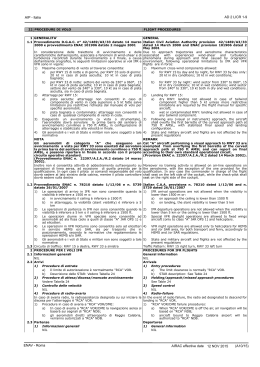
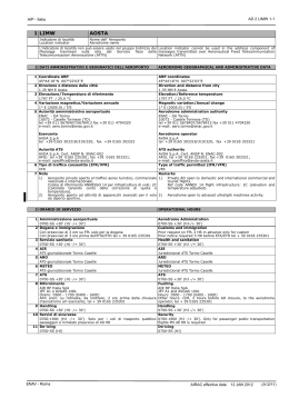
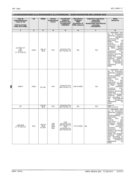
AD 2 LIMW 1-5
AIP - Italia
RWY
ID
ASSE CENTRALE PISTA
RCL
Spaziatura
Colore
Spacing
Colour
(M)
Lunghezza
Length
(M)
1
09
27
RWY
ID
6.1
630
570
300
630
570
300
6.2
30
30
30
30
30
30
6.3
W
W/R
R
W
W/R
R
FINE PISTA
RWY END
Colore
Colour
1
09
Intensità
Intensity
Lunghezza
Length
(M)
6.4
LIH
LIH
LIH
LIH
LIH
LIH
7.1
7.2
7.3
7.4
46
46
W
Y
LIH
LIH
1007
492
46
46
W
Y
LIH
LIH
RTIL
CGL
Note
Remarks
10
11
12
1) PAPI RWY 09:
protezione 5 km /
protection 5 km
Lunghezza
Length
(M)
Colore
Colour
9.1
9.2
R
NIL
Intensità
Intensity
998
501
SWY
8
BORDO PISTA
RWY EDGE
Spaziatura
Colore
Spacing
Colour
(M)
NIL
2
2)
RWY
EDGE
LIGHTS:
luci aggiuntive di
bordo
pista
omnidirezionali
lunghezza 1499 m,
spaziatura 46 m,
colore
bianco,
intensità
LIL
/
additional
omnidirectional
RWY edge lights,
length 1499 m,
spacing
46
m,
colour
white,
intensity LIL
1) PAPI RWY 27:
protezione 5 km /
protection 5 km
NIL
2) PAPI OFF SET
3.6°
27
R
NIL
NIL
2
3)
RWY
EDGE
LIGHTS:
luci aggiuntive di
bordo
pista
omnidirezionali
lunghezza 1499 m,
spaziatura 46 m,
colore
bianco,
intensità
LIL
/
additional
omnidirectional
RWY edge lights,
length 1499 m,
spacing
46
m,
colour
white,
intensity LIL
NIL
15 ILLUMINAZIONE AGGIUNTIVA, ALIMENTAZIONE SECONDARIA OTHER LIGHTING, SECONDARY POWER SUPPLY
1 Localizzazione ABN/IBN, caratteristiche e orari
Coordinate ABN: 45°44'22''N 007°21'51''E
Caratteristiche: NIL
Orario: NIL
2 Localizzazione LDI e luci
Localizzazione anemometro e luci
LDI: NIL
Anemometri:
1 a circa 94 m dalla RCL, 78 m dalla THR RWY 09 lato sinistro
1 a circa 84 m dalla RCL, 181 m dalla THR RWY 27 lato destro
3 Illuminazione bordo e asse centrale TWY
Vedi carta AD in vigore
4 Alimentatore secondario/Tempo di intervento
NIL
5 Note
NIL
16 AREA DI ATTERRAGGIO ELICOTTERI
1 Posizione
Coordinate: 45°44’20’’ N 007°22’04’’ E
ENAV - Roma
ABN/IBN location, characteristics and hours of operation
ABN Coordinates: 45°44'22''N 007°21'51''E
Characteristics: NIL
Hours: NIL
LDI location and lights
Anemometer location and lights
LDI: NIL
Anemometers:
1 at about 94 m from RCL, 78 m after THR RWY 09 left side
1 at about 84 m from RCL, 181 m after THR RWY 27 right side
TWY edge and centre line lighting
See AD chart in force
Secondary power supply/Switch over time
NIL
Remarks
NIL
HELICOPTERS LANDING AREA
Position
Coordinates: 45°44’20’’ N 007°22’04’’ E
AIRAC effective date
12 JAN 2012
(A12/11)
AD 2 LIMW 1-6
AIP - Italia
2 Elevazione
543 m / 1780 ft
3 Dimensioni, superficie, resistenza, segnaletica
Dimensioni: 27 m x 27 m
Superficie: calcestruzzo
Resistenza: 10 tonnellate
Segnaletica: linea bordo bianca spessore 30 cm; triangolo equilatero
spessore 1 m e lato 9 m
4 Orientamento
09-27
5 Distanze dichiarate
NIL
6 Luci
ICAO APP PATH 09/27: lunghezza 210 m, 7 luci bianche, fisse,
omnidirezionali /HI; 4 luci bianche, flashing in sequenza direzionale/HI
A-PAPI 09/27: 6° MEHT 5.2 m
FATO: 40 luci gialle, omnidirezionali, sul perimetro del quadrato /HI
Elevation
543 m / 1780 ft
Dimensions, surface, strength, marking
Dimensions: 27 m x 27 m
Surface: concrete
Strength: 10 tons
Marking: white side stripe marking 30 cm thick; equilateral
triangle, 9 m side, 1 m thick
Bearing
09-27
Declared distances
NIL
Lighting
ICAO APP PATH 09/27: length 210 m; 7 steady omnidirectional,
white lights /HI; 4 sequenced directional flashing, white lights, /HI
A-PAPI 09/27: 6° MEHT 5.2 m
FATO: 40 yellow, omnidirectional lights on each side of the square/
HI
AIMING POINT: 6 luci bianche, omnidirezionali, sul perimetro del AIMING POINT: 6 white, omnidirectional lights on each side of the
triangle/HI
triangolo /HI
See also AD 2 LIMW 2-3
Vedi anche AD 2 LIMW 2-3
7 Note
Remarks
NIL
NIL
17 SPAZIO AEREO ATS
ATS AIRSPACE
Designatare e limiti laterali
Designation and lateral limits
Limiti
verticali
Vertical
limits
Classificazione dello
spazio aereo
Airspace
classification
1
Aosta ATZ
Linea congiungente i punti/line joining
following points:
45°45'55''N 007°16'03''E
45°46'39''N 007°27'32''E
quindi arco di cerchio in senso orario
raggio/then arc of circle in clockwise
direction radius 4.5 NM con centro su/
centred on:
45°44'18''N 007°22'03''E
fino a/till point
45°42'40''N 007°28'02''E
quindi/then
45°41'56''N 007°16'35''E
quindi arco di cerchio in senso orario
raggio/then arc of circle in clockwise
direction radius 4.5 NM con centro su/
centred on:
45°44'18''N 007°22'03''E
fino a/till point
45°45'55''N 007°16'03''E
2
3
8000 FT
AMSL
G
18 SERVIZI DI COMUNICAZIONE ATS
Servizio
Service
1
Emergenza
Emergency
AFIS
Nominativo
dell’unità ATS
Lingua
ATS unit call sign
Language
4
Aosta Aerodrome
INFO
IT/EN
Note
Remarks
5
6
15000 FT
1) WI Milano FIR
ATS COMMUNICATION FACILITIES
Nominativo
Call sign
2
Frequenza MHZ
Frequency MHZ
3
Orario
Operational hours
4
NIL
121.500 MHZ
vedi note/see remarks
Aosta Aerodrome INFO
Altitudine di
transizione
Transition
altitude
119.950 MHZ
vedi note/see remarks
Note
Remarks
5
1) HR: 0700-SS + 30' (HJ -/+ 30')
1) HR: 0700-SS + 30' (HJ -/+ 30')
Altri orari PPR 24 HR/Other HR PPR 24 HR
2)Vedi/see AFIS note/remarks
AFIS NOTE/REMARKS
1)
La frequenza 119.075 MHz è assegnata per esigenza dell'Aviazione Generale e per l'Aeroclub, tale frequenza non deve essere usata per
scopi ATS/Frequency 119.075 MHz assigned for General Aviation and Aeroclub needs, such frequency must not be used for ATS purposes
AIRAC effective date
12 JAN 2012 (A12/11)
ENAV - Roma
Scaricare