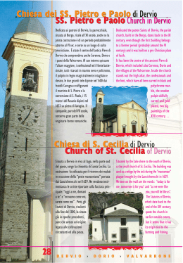
b e n v e n u t i
a …
we lco m e t o…
I T A L Y
›
L A G O
D I
C O M O
›
L A K E
C O M O
›
I N F O
›
I N F O R M A Z I O N I
www.dervio.org www.comune.dorio.lc.it
www.valvarrone.com
www.prolocodervio.it
D E R V I O
›
D O
R
I O
›
V
A
L
V
R
Fotografie
Angelo Colombo - Giuseppe Arnoldi - Walter Buzzella
Gabriella Bettega - Gruppo Fotoamatori Dervio
A
R
Traduzioni
O
Federico Rigamonti - Mara Orsi
Rupert Wickens - Giovanna Bianchi Bazzi
› PRO LOCO DERVIO
0341.80.60.60
› UFFICIO TURISTICO DERVIO
E
N
Progetto grafico e stampa: Grafiche Rusconi Bellano
Realizzato a cura di:
Angelo Colombo - Assessore al turismo di Dervio
Gabriella Bettega - Assessore al turismo di Dorio
Walter Buzzella - Presidente Unione Comuni Valvarrone
Fiorenzo Rusconi - Presidente consulta turismo di Dervio
Antonello Colombo - Segretario consulta turismo di Dervio
Nicolò Simone - Componente consulta turismo di Dervio
Juri Scandolara - Componente consulta turismo di Dervio
Damiano Polti - Componente consulta turismo di Dervio
0341.80.44.50 › 0341.80.41.13
Gentile ospite, benvenuto nel nostro territorio!
Dear guest, welcome to our territory!
02
Dervio, Dorio ed i comuni della bassa Valvarrone,
posti sulla sponda orientale dell’alto Lago di Como
tra le prealpi Orobie, sono un territorio culturalmente omogeneo che nel passato costituiva la
Pieve di Dervio. Nella nostra terra le essenze
mediterranee si fondono con quelle alpine ed al
suo interno si scoprono gli ambienti più diversi,
dalle rive incantate del lago alla maestosità delle
montagne che raggiungono i 2600 metri di altitudine. Un territorio da vedere, ma soprattutto
da scoprire, con un ambiente ancora intatto, dove
trascorrere piacevoli soggiorni in tutte le stagioni
dell’anno, grazie a un clima mite e privo di nebbia
in inverno, ma fresco e ventilato in estate.
Dervio, Dorio and the villages of the low Valvarrone,
located on the eastern side of the high Lake Como,
among the Orobic pre-Alps, are a culturally homogeneus territory, which in the past formed the
“Pieve di Dervio”.
In our land the mediterranean essences merge
with the alpine ones and there you can discover
a lot of different landscapes, from the enchanting
shores of the lake to the majestic mountains which
reach 2600m. A territory to be seen but above all
to be discovered, with an environment still intact,
where to spend pleasent stays during every seasons,
thanks to a mild climate with no fog in winter
and fresh and airy in summer.
Lago, montagna, fiume, verdi boschi, rappresentano il patrimonio naturale di queste località e
ben si fondono con la bellezza delle opere storico–artistiche dislocate sul territorio offrendo
numerose opportunità agli amanti della natura
ed agli sportivi. Questo grazie alla possibilità di
balneazione lungo le spiagge, di pratica della vela,
wind-surf e kitesurf, della pesca sul lago e lungo
il fiume; inoltre per gli appassionati della montagna, grazie alle numerose passeggiate fra i boschi
in una natura incontaminata e ricca di fauna, gli
itinerari ciclistici e le escursioni su alcune cime
superiori ai 2000 m. delle montagne circostanti.
Lake, mountains, river, green woods represent the
natural heritage of these resorts and form a
fantastic mix with the beauty of this historicalartistic works located on the territory which offer
a lot of opportunity to the lovers of nature or
sports. They have the opportunity to practise
bathing along the beaches, sailing, windsurfing
and kitesurfing, and fishing both in lake and
river; besides, for the fans of the mountain, there
are several walks among the woods in an uncontaminated nature rich in fauna, cycle itineraries
and excursions to some tops of the close mountains,
higher than 2000 mts.
D E R V I O
›
D O R I O
›
V A L V A R R O N E
Collegamenti Connections
The territory, among the most interesting ones in
the High Lario, is located at about 30 km north of
Lecco and at about 80 km from Milan. It is easily
reachable by the freeway 36, from Lecco to Colico,
taking the exit Dervio (opening in the 2006) or, to
enjoy the view, by the provincial road 72 which
crosses the villages of the oriental coast of the Lake.
To reach the resorts of Valvarrone, you can take the
main roadown SP 67 which, starting from Dervio,
reaches the villages of Vestreno, Sueglio, Introzzo
and Tremenico, to then continue towards Pagnona
and Premana, in the high Valvarrone. Another
connection is offered by the public transport, through
the railway of the Milano – Sondrio line; the station
is situated in the centre of Dervio and Dorio, and a
bus service reach the four villages of Valvarrone.
Il territorio, fra i più interessanti dell’Alto Lario,
è posto a ca. 30 Km a Nord di Lecco e a ca. 80
Km da Milano. Si raggiunge facilmente con la
superstrada 36, da Lecco a Colico, uscendo allo
svincolo di Dervio (apertura nel 2006) oppure,
per gustarsi il paesaggio, seguendo la strada
provinciale 72 che attraversa i centri abitati della
riviera orientale del lago. Per raggiungere i paesi
della Valvarrone si utilizza la provinciale 67 che
partendo da Dervio raggiunge i comuni di Vestreno, Sueglio, Introzzo e Tremenico per poi proseguire sino a Pagnona e Premana nell’alta Valvarrone.
Altro collegamento è ottenuto con i mezzi pubblici,
tramite la ferrovia della linea Milano – Sondrio,
la stazione ferroviaria si trova nel centro di Dervio
e Dorio ed un servizio bus raggiunge i quattro
paesi della Valvarrone.
Svizzera
Chiavenna Maloja
Valtellina
Sondrio
COLICO
GRAVEDONA
MENAGGIO
BELLANO
ARGEGNO
7
.6
S.P
DORIO
DERVIO
LUGANO
VALVARRONE
VARENNA
PREMANA
6
.3
S.S
BELLAGIO
MANDELLO
S.P. 62
2
.7
S.P
VARESE
CHIASSO
LECCO
COMO
6
.3
S.S
Malpensa
BERGAMO
Venezia
Torino
Orio Al Serio
MILANO
D E R V I O
›
D O R I O
›
V A L V A R R O N E
Linate
03
Il territorio The environment
Originata da depositi di materiale alla foce che
il fiume Varrone ha rapito con lavoro secolare ai
fianchi della Valvarrone la penisola derviese si
protende nelle acque del Lario con una forma
conoide. Si raccorda a nord con un piccolo promontorio dove sorge Corenno Plinio e proseguendo
lungo la sponda del lago si trova l’abitato di
Dorio posto ai piedi del monte Legnoncino.
Sopra Dervio si sviluppa la Valvarrone con i
paesi di Vestreno, Sueglio Introzzo e Tremenico
posti sul versante destro e sovrastati dal monte
Legnoncino (1714 m) ed il monte Legnone (2610
m) la cima più alta delle prealpi orobiche e della
provincia di Lecco, mentre sul lato sinistro della
valle si erge il monte Muggio (1799 m).
The peninsula of Dervio comes from the sediment
of material transported by the river Varrone. The
peninsula leans forward in the lake in a cone
form. At north join a little promontory where
Corenno Plinio is located and going on along the
shore of the lake you’ll find Dorio, situated at
the foot of the mount Legnoncino. Above Dervio
spreads the Valvarrone, where Vestreno, Sueglio,
Introzzo and Tremenico is situated. They are on
the right side of the valley and are dominated
by the mount Legnoncino (1714m) and by the
mount Legnone (2610m), which is the highest
summint of the Orobic pre-alps and of the province of Lecco; on the left side rise the mount
Muggio (1799m)
Dati Statistici
Statistical Data
04
Abitanti
Inhabitants
Superficie
Area Kmq
Altitudine
Altitude
Patrono
Patron
Dervio
Dorio
Introzzo
Sueglio
Tremenico
Vestreno
Totale
2.780
350
140
170
230
300
3970
11,7
12,7
3,8
4,2
8,9
2,7
44
215
210
704
785
754
587
Ss. Pietro e Paolo
S. Giorgio
S. Antonio Abate
N. S. di Lourdes
S. Agata
S. Paolo e Giacomo
D E R V I O
›
D O R I O
›
V A L V A R R O N E
Dervio
Dervio per le sue caratteristiche è il capoluogo del
territorio, di origini molto antiche è stato un borgo
importante e fortificato sin dall’epoca romana, grazie
alla sua posizione strategica posta sulla strada che
collegava la Valtellina a Milano. Il suo massimo
sviluppo lo ha avuto da fine 1800 ad oggi con la
crescita economica che ha portato a triplicare la
popolazione, negli anni più recenti lo sviluppo
demografico si è arrestato, ma è in rapido incremento
il turismo che gradatamente sta diventando il settore
portante dello sviluppo economico del paese. Grazie
alle sue bellezze naturali ed artistiche ed i recenti
interventi infrastrutturali, Dervio è destinato a
diventare una delle località importanti per il turismo
del lago di Como e già ora è considerato il “paradiso
della vela”, con la sua posizione ideale protesa nel
lago sempre ventilata e le quattro scuole veliche.Il
lungo lago di notevole estensione, recentemente
rinnovato, offre un paesaggio elegante e naturale,
dove passeggiare diventa relax e divertimento.Ma
se volete provare una forte suggestione storica e
immaginare le vicende del lago durante il Medioevo,
dovete fare una visita alla frazione di Corenno Plinio
Dervio is the chief town of the area thanks to is
peculiar features. It is a very ancient and important
village, fortified in the Roman time and located
in a very strategic position on the street, which
connected the Valtellina to Milan. From the end of
1800 to nowadays Dervio has had its biggest
development thanks an important economical
growth, which has allowed a tripling of the population, in the last years the increase in population
has had a stop, but the tourism is having an
important growth, and it is becoming the most
important trade. Dervio is becoming one of the
most important touristic centre of the lake thanks
to its natural and artistic beauties and the recent
infrastructural works. Dervio is considered the
“sail paradise” thanks to its perfect and airy
position and to its 4 sail-school. Along the lake
side promenade you can have both relax and fun
in an enchanting and elegant landscape. If you
would like to feel an historical fascination and try
to imagine the events during the Middleage you
should visit the village of Corenno Plinio, one of
the most characteristic place of the lake. It is on
uno dei luoghi più caratteristici del Lario. E’ posto
su uno sperone roccioso a picco sul lago dominato
dal castello recinto dei conti Andreani, contornato
da antiche case e dalla chiesa di S. Tommaso di
Canterbury con i bellissimi sepolcri, la piazza e le
antiche stradine in acciottolato e le scale scavate
nella roccia che scendono sino al lago.
a rockhill overlooking the lake, dominated by the
majestic castle of the Count Andreani. The castle
is sorrounded by ancient houses and the church
of S. Tommaso of Canterbury with its magnificent
sepulchres, the place, the romantic cobblestones
streets and the staicase in the rock, which go down
to the lake.
D E R V I O
›
D O R I O
›
V A L V A R R O N E
Dervio
› Altitudine 220 m.
› Abitanti 2780
(derviesi)
› Superficie kmq 11.7
› CAP 23824
› Altitude: 220m
› Inhabitants: 2780
› Area: 11,7 kmq
› CAP: 23824
05
Stradario di Dervio
MONASTERO
RO DE
L VIA
RONCACCI
SVINCOLO
S.S. 36
NDANTE
VIA AL MONASTERO
CASTELLO
VIA
CORENN
VIA
O PLIN
IO -
COLI
DE
IR
ON
11
VA
LV A
RR
ON
E
23
VIA P
ER V
CH
ETT
ESTR
I
CO
ENO
PIANEZZO
VIA ALL E PRE SE
SENTIE
VIA AL CASTELLO
2
.7
S.P
LDI
IBA
GAR
VIA
NI
BRE
A
NO
LA
IO
VIA I° MAGG
PPA
VIG
29
I
VIA DON INVERNIZZI
STIZIA
EGORIO
27
VIA CORTEDI GIU
D
VIA S. GR
VIA
O
P.G.
R
G
UBI
NI
A
VIA
NTI
VIA GRE PPI
XXV
VIA ILE
APR
PPI
L
VIA MARTIRI DELL
A LIBERAZIONE
ROM
V. XX SETTEMBRE
A FO
VIA AI MO
P.ZA IV
NOVEMBRE
VIA S. G. BOSCO
GRE
A
OZZI
VIA
PON
ALL
VIA E. BU
I
A CA
VIA
7
VIA
ALL
I
AZZIN
PPA
ALLA FO
VIA
O
ON
VIA M
I
LOMB
V. XX SETTEM
T
V. X
X
T
V. CO
ANZ
LA FOPPA
VIA
T.
VIA S
MAG
O
P.TTA
CAVOUR
V. M
VIA
O
VIA
E
NIO
GLI
T
OTTO
I
P. G
T
PLI
VIA
A
VIA
10
SET
M
I CHIO
O
SI
M
ANDO D
IAZ
VIA VA LV
O
S
O
IA
GG
RO
C
VIA
CC
. RO
A
ALL
I A
AR RO NE
G
VIA
VI A CU NE
I A
LL A
V
VIA CROCETTA
VIA ARM
VIALE DELLE RIM
EMBRANZE
C
A
GER
ALL A
O
12
M
33
VIA
VIA
34
BER
O
I
TAR
37
NI
VIA D
9
STRADA
31
SENTIERO DE
COLIC
VIA
MAR
L VIA
ONA
SSO
NDA
NTE
CORENNO PLINIO
O
VIA PIETRO BA
VIA AL MONASTERO
DOGLIO
VIA IV NOVEMBRE
VIA
I
L A G O
IANDA
DERVI
D I
D E R V I O
P.ZA DEL
PORTO
VIA
PIE
TRO
BAD
G
OG
DEI PRAT
I
I
LPIN
GLI A
8
NTE
O
VIA
AL
15
LA
DA
RS
EN
A
26
LIO
.M.ANDREARI
VIA CANDIAN
A
V. ANDREANI
DER
VIA S. MARIA
21
V
DEL V
24
13
RE
IA P
IERO
S.P. 72
P.ZA
GARIBALDI
06
T
SEN
E DE
I
BORGO
VIAL
P.ZA XI
FEBBRAIO V. BERGAMIN
VIA ALLA BOLDONA
C O M O
›
D O R I O
›
V A L V A R R O N E
O N LU
IGI PE
NA
Map of Dervio
LDI
AL CA
VI A
SI
IBA
GAR
VIA
T.
I CHIO
SET
5 SCUOLA ELEMENTARE
6 PALESTRA
V. X
X
RE
VIA E. BU
V. XX SETTEMB
OTTO
VIA S
O
PA
22
ZZI
1
32
4 3
SENTIERO DEL VIA
9 PARR. SS. PIETRO E PAOLO
BELLANO
6
36
5
38
7 STAZIONE F.S.
8 UFFICIO TURISTICO
P.ZA IV
NOVEMBRE
VIA S. G. BOSCO
NDANTE
I
OP
I
V.
P.ZA
SCHENARDI
TA
VOL
AZZIN
VIA M
2
ON
AF
4 SCUOLA MEDIA
GLI
NI
O
VIA
V
PIA
3 SCUOLA MATERNA
I
P. G
VIA
MAG
ANZ
ALL
NINA
VIA
LO M B
MAI
E
P.TTA
CAVOUR
V. M
VIA
VIA MAD
ON
28
V. CO
1 MUNICIPIO
2 UFFICIO POSTALE
VIA VA LV
V IA C
IAZ
S T ELL O
UNEL
ANDO D
AR RO NE
VILLA
LA
VIA ARM
10 CHIESA S. QUIRICO E GIULITTA
11 CHIESA S. LEONARDO
VIA D
‘AOSTA
UCA D
12 S. GREGORIO
0
BALMA
SCIA
I A
14 CHIESA S. CECILIA
15 PARCO PUBBLICO BOLDONA
O
16 CENTRO SPORTIVO
17 CENTRO VELA (L.N.I.)
RCO
V
13 S. TOMMASO DI CANTERBURY
I
MA
VIA DELLE VIGNE
T
T
VIA
G
M
O
C
I A
T
A
T
CILIA
EDEIA
M
O
VIA S. CE
VIA MARA
VIA S
DUCA D‘AOSTA
E
NI
25
VIA
14
18 CAMPEGGIO (EUROPA)
19 CAMPEGGIO (TURISPORT)
DEL
17
LE V
IGN
20 CENTRO VELA (C.V.D.)
E
21 CASTELLO DI CORENNO PLINIO
M
OCC
O LO
O
AL R
VIA
VIA ALLA GERA
VIA
O
16
RIC
C
EN
OF
ER
MI
VIA
CO
VIA
INC
L
ON
I
I
UIG
IP
EN
ATI
VIA
C
AL
AN
TIE
RE
TA
29 BANCA
30 CIMITERO DI DERVIO
31 CIMITERO DI CORENNO PLINIO
MI
OS
28 BANCA
32 BIBLIOTECA
ER
ALL
E
OF
VIA
N
L LO
RIC
D
AV
EN
VIA
L. D
VIA
ATI
O
PER
26 PONTILE BATTELLI
27 FARMACIA
O
NIC
G
A
A
V. G
24 PORTO VECCHIO
L
30
VIA
EI
LIL
NI
D
35
CO
23 CASTELLO
25 PORTO
18
R
MA
22 CASTELVEDRO
33 ORATORIO
34 CENTRO DIURNO ANZIANI
39
EG
LI
UL
IVI
35 GUARDIA FORESTALE
AG
OD
36 CENTRO VELA (ORZA MINORE)
OL
19
LUNGOLA
GO DEG
NG
20
LU
37 CINE-TEATRO PARADISE
38 SEDE PRO LOCO
LI ULIVI
39 SCUOLA WIND SURF
40
D E R V I O
›
40 AREA KITESURF
D O R I O
›
V A L V A R R O N E
07
Dorio
Dorio
› Altitudine 210 m.
› Abitanti 350
(doriesi)
› Superficie kmq 12.7
› CAP 23824
7
08
V IA P E
O
6
MITERO
LI A
1
L PI
RTI NI
NI
TORCHIEDO
V. PER TO
RCHIED
V
R GI
VIA AL CI
D EG
V. G. BARILI
I ERLO
P
V. D. ALIGH
IER
R
V. SCAL A
GIO
V. PASU
Z
ZI
V. C
EN
TRA
LE
A
IO
V IA
.
VI A PI AV E
IA P
O
ER T I N I
CORENN
O PLINIO
- DERVIO
S. P. 72
VIA UNIONE
L A G O
RIVETTA
BIO
TT I
V I A C RO
ON E
VI
CA
VIA S
3
2
NT
VE
PETA
DENZA
V. INDIPEN
VIA
COLICO
PIA
ST
VIA
L
AA
LLO
RONCHI DI VESGALLO
GARAVINA
R AGG
HIE
S
I S TI
DONE
VIA
A
V. TE R
V. BAT
T
A
VI A B A T T I S T I
LA C
LT
A
5
A AL
V IA A
VIA
SAN ROCCO
VIA AI BOSC H
I
VIA PER MAND
ONI
CO
› Altitude: 210m
› Inhabitants: 350
› Area: 12,7 kmq
› CAP: 23824
Come per la maggior parte dei paesi affacciati sul
lago, Dorio sbuca da dietro una curva e appare
subito chiara quale sia stata la sua evoluzione,
soprattutto grazie al vecchio nucleo di "Mandonico"
sovrastante l'attuale abitato che fu il primo insediamento abitativo, posto in una posizione arroccata per proteggersi dalle frequenti invasioni
abitato sino alla fine del 1700. Il passaggio quasi
parallelo al lago della ferrovia e della strada
provinciale ha fatto sì che il paese si sia sviluppato
sopra e lungo queste arterie, preservando le
You will find Dorio just behind a bend, like the most of
spiagge. Alcune vengono baciate dalla “breva”, il
the villages of the lake. The ancient “Mandonico”, the first
vento lariano che spira da sud dalle 10 alle 18 ed
è raramente violento e sono quindi meta preferita inhabitated centre (since 1700), dominate Dorio and is
dai surfisti, altre, di ghiaia più fine, sono frequentate located in a strategic position to protect oneself from the
frequent invasions. The village has developed along the
dai bagnanti. Dorio non è solo spiagge, ma anche
storia e montagna. Questo felice connubio lo offre provincial street and the railway , so the beaches are
already pure and untouched. Some of them are popular
il "sentiero del viandante", che attraversando il
vecchio borgo accompagna sulle pendici dei monti among the surf-lovers, thanks to the “Breva”, the slight
wind which blows from 10 a.m. to 6 p.m., the others are
dove abbondano boschi di castagni e di cui in
made of a beautiful sand and so are attended by a lot of
passato venivano sfruttati i pascoli. Ne restano a
testimonianza i nuclei di "Perdonasco", "Rainelda" holidaymakers. Dorio is not only beaches, but also history
e "Sparesee" le cui stalle sono state trasformate in and mountains. You will find mix thanks to the “sentiero
cascine per trascorrervi i periodi estivi. A Dorio ci del viandante”, which pass through the village and goes
on the hills, where you will find a lot of chestnut-tree and
si rende conto di quella che un tempo era la vita
in tutti i paesi del Lario, quel vivere tra il lago e la where in the past the were wide pastures. In the centres
of “Perdonasco”, “Rainelda” and “Sparesee”
montagna, conquistando all'uno
tourists will find a lot of stables, which nowadays
e all'altra quel poco che l'acqua
1 MUNICIPIO
are been transformed in houses where to pass
e la terra potevano dare per vi2 STAZIONE FS
vere. La scure che spicca al centro 3 PARROCCH. S. GIORGIO the summer. Visiting Dorio you can understand
how the inhabitants of the lake liked in the
dello stemma del paese, ricorda
4 CHIESA S. GIORGIO
past, between the mountains and the lake,
il ritrovamento di un "Paalstab"
5 CHIESA S. ROCCO
trying to get from the land and the water what
(scure) dell'età del Bronzo, con- 6 CENTRO SPORTIVO
they could offer to live. The hatchet in the centre
servato ora nel museo di Como.
7 RESIDENCE TURISTICO
of the crest of Dorio reminds to an ancient
“Paalstab” (hatchet) form the Bronze-time,
CASE ASEN
MANDONICO
which has been discovered
PANICO
SENTIERO DE
in this area and kept
L VI A N D A N T E
4
SENTIERO D
EL V I
in the museum of
AND
AN T
E
VIA DE
Como.
L C A N ALINO
VI
D E R V I O
D I
›
C O M O
D O R I O
›
V A L V A R R O N E
Valvarrone
La valle del torrente Varrone è la parte più aspra
e suggestiva della sponda orientale del Lario. I
monti che la dividono dalla Valtellina costituiscono
la catena più elevata del territorio lecchese,
questa valle è addossata ai monti Legnone e
Legnoncino ed è percorsa dal torrente omonimo
che dai monti sopra Premana va a sfociare nel
lago, a Dervio. La parte bassa della valle è un
territorio omogeneo per storia e tradizioni ed
appare quindi appropriata la recente costituzione
dell’Unione dei Comuni della Valvarrone. I quattro
comuni che ne fanno parte e cioè Introzzo, Sueglio,
Tremenico e Vestreno, contano complessivamente
poco meno di mille abitanti.
L’economia di questa parte della valle è sempre
stata povera e l’emigrazione era abituale anche
secoli or sono, ma la particolare posizione orografica del territorio può favorire lo sviluppo del
The valley of the stream Varrone is the most steep
and suggestive part of the eastern side of the
lake. The summits, which separate it from the
Valtellina, are the highest mountains in the
province of Lecco; this valley is located next to
mount Legnoncino and the mount Legnone, and
is passed by the river Varrone, which goes from
the summits above Premana to the lake, in Dervio.
The low part of the valley is a homogeneus territory how to concern history and traditions, and
so the union of Introzzo, Sueglio, Tremenico and
Vestreno is a right thing; they form the “Unione
dei Comuni della Valvarrone” and less of 1000
inhabitants. The economy of this area of the
valley has always been poor and the inhabitants
have always emigrated; but the peculiar feature
of this position can help the tourism. From the
villages of the valley you can start a lot of easy
turismo. I paesi della valle sono un ottimo punto
di partenza per facili escursioni alla portata di
tutti lungo le antiche strade militari, attraverso
pascoli e boschi di larici con angoli naturali di
particolare bellezza da cui si godono splendidi
panorami. Camminando per le strette viuzze dei
paesi sembra invece di fare un salto indietro nel
tempo con il sapore antico dei ballatoi in legno,
dei tetti di ardesia e delle donne ancora intente
presso secolari lavatoi.
excursion on the ancient military streets, through
pastures and woods of larches in a fantastic
nature, from where you can admire wonderful
landscapes. Walking through the narrow streets
of the villages you will fell like in the past among
ancient balcony made of wood, roofs of slate and
women washing in age-old wash-tub.
D E R V I O
›
D O R I O
›
V A L V A R R O N E
Valvarrone
09
Introzzo
› Altitudine 704 m.
› Abitanti 132
(introzzesi)
› Superficie kmq 3,81
› CAP 23835
› Altitude: 704m
› Inhabitants: 132
› Area: 3,81 kmq
› CAP: 23835
Introzzo
Introzzo è paese antico, addirittura con parti arcaiche, che rispecchia la severità della valle intorno,
fra boschi di faggi e larici.
Caratteristica la chiesa di S. Antonio a lato di un'
Era (aia) fra rocce e terrazze.
Il nome risale al Medioevo quando tutta questa terra
era chiamata Mont’Introzzo e si riferiva all'intera
Valvarrone.insieme agli altri paesi di Tremenico,
Sueglio e Vestreno, testimoniando l'importanza del
paese, ancor oggi indicato come il capoluogo di
questa vallata. Chiunque, forestiero, decidesse di
fermarsi in paese per qualche tempo doveva pagare
una tassa di soggiorno, un “introgium”. E doveva
pagarlo anche chi assumeva una carica pubblica. Il
Introzzo is an ancient village with archaic parts,
which reflect the structure of the valley, among
woods of larches and beeches. The church of S.
Antonio next to an “Era” (form-yard) between
rocks and terraces is to visit. The name comes
from the Middle-age, when this whole land was
called “Mont’Introzzo”, giving evidence to the
importance of the village, nowadays still the chief
town of the valley. Every foreigner who decided
of stoppin in Introzzo, had to pay a tax for stay
, an “introgium”, had to pay it also civil servants.
This is the explanation of the place name.
The village is formed by anvient houses built by
grey rocks, one next to the other, on narrow
VI A
toponimo sembrerebbe così spiegato. Il paese è
cobblestones streets. Introzzo has always been an
costituito da antiche case costruite in blocchi di
isolated village; in fact the first real streets to
reach it was built just during the firs
pietra grigia, poco distanti l’una dalworld war. Lavadee and the Roccoli
l’altra, affacciate su viottoli
CRESTE
are little villages to visit, between
acciottolati. Introzzo ha
the mount Legnoncino and the
sempre patito un certo
3
mount Legnone, where to
isolamento se si pensa che
start interesting
una strada vera e propria
VI
A
excursion.
fu costruita per ragioni
RO M A
VIA
S . ANT
ON I O
militari solo durante la
1
RA
Prima Guerra Mondiale.
SA
RE
VIA U
CE
MB
IA
2
VIA
ER V
V I A DE L L
Da segnalare sono anche le
E GN O
FU
SI
località di Lavadee e dei
Roccoli Lorla poste fra il
V IA A
VIC O L O D E
TRONE
LL A P IA
monte Legnoncino ed il
ZZ A
VI A G E
RO
Legnone, luoghi di vilVIA SCIR
ESA
VI A RO M
A
leggiatura e punti di partenza
S.P. 67
per interessanti escursioni.
1 MUNICIPIO
NI O
VIA
V I A D E L L’ E
VIA XXV APRIL
NTO
E
S. A
SCA
LA
N CH I
LL
A
E G NO
OL
FICIO
O RT
VI A R O
VIA P
VIA S. BENE
TO
LA
2 SOCCORSO VALVARRONE
3 CHIESA SANT’ANTONIO
10
D E R V I O
›
D O R I O
›
V A L V A R R O N E
Sueglio
È un grazioso paese attraversato da numerose e
pittoresche viuzze e raccoglie, sulle pendici della
montagna, eleganti edifici barocchi. Se è vero che
il capoluogo della Valvarrone è Introzzo, è altrettanto
vero che Sueglio ebbe una grossa importanza: sorge
qui, infatti, la chiesa parrocchiale alla quale fanno
riferimento anche le comunità di Introzzo e Vestreno.
E' dedicata a San Martino e anche questo ci ricorda
come un tempo Sueglio fosse una località di rilievo
nella mappa dei presidi longobardi. Qui sorgeva,
infatti, una torre di guardia e, sul monte Legnoncino,
una cappelletta dedicata a San Sfirio, un santo il
cui culto risale all'epoca longobarda.
Da Sueglio è possibile raggiungere diverse località,
It is charming villages, passed by a lot of pictoresque
narrow streets and offers smart baroque buildings
to admire. The chief town of the Valvarrone is
Introzzo, but also Sueglio had a big importance :
here you can find the parish church of Sueglio but
also of Introzzo and Vestreno. It is to San Martino
and was to it rose an ancient watchtower, on the
mount Legnoncino was a little chapel consacrated
to San Sfirio, a longobard Saint. In fact Sueglio was
an important repost by the Longobards. From
Sueglio you have the possibility to reach a large
number of resorts, such as the little lake of Artesso,
where a trail passing by the “ Rifugio Bellano”
arrives to the “Roccoli Lorla”. Walking along this
V I A M U L AT I E R A
tra cui il laghetto di Artesso dove un sentiero che
track you will meet the old trenches of the “Cadorna”
passa dal Rifugio Bellano porta ai Roccoli Lorla.
line, made during the first World War, which recently
Camminando lungo questo tracciato s’incontrano
have been arranged to visit. Going down from the
ancora le vecchie trincee e postazioni della linea
lake of Artesso to about 1100m, you will arrive to
Cadorna realizzate durante la Prima Guerra Mon- Sommafiume, a little village attended above all
diale che recentemente sono state sistemate per
during the summer.
1 MUNICIPIO E POSTA
renderle visitabili. Scen2 CHIESA S. BERNARDINO
dendo dal laghetto di
MONTE LOCO TOCO
3 ORATORIO
Artesso fino a quota
4 CHIESA SAN MARTINO
VIA P
1100 circa, si arriva
E R S O M M AF I U M E
invece a SomN
CO
VA S
VIA
mafiume, un
VIA CANOL
E
LL
S TA
nucleo abitato
A
VIA
ME
V I A CR
ELL
IU
OS E
AB
TUR
TT
principalVIA
SC
VI A L A CU RV
E
A
A
VI
mente duV. MASONE
2
INO
O
rante il
AR
V I A R O MA
O ZZ
VI A I
VIA S A N B ER N
VI A IN T R
NT RO ZZO
periodo
VIA
BOL
ZE
ZZ A
V. NU
N U O V L L A P IA
O VO VILL
estivo.
AA
E
A GGI
C A P P EL LE TT
A P IAV
IVELLO
Sueglio
› Altitudine 785 m.
› Abitanti 165
(suegliesi)
› Superficie kmq 4,22
› CAP 23835
› Altitude: 785 m
› Inhabitants: 165
› Area: 4,22 kmq
› CAP: 23835
AN
MP
ILE
IA
NAR
VIA CASC
AT
A
V. C
A S PA R E
VI
RN
VIA
NO
RTI
VI A S
. MA
VIA DEL L’ A SI L O
4
3
D E R V I O
›
A
1
V IA
VIA G
O
CA
VIA LA TORRE
D
V. CASTELLO
D O R I O
67
S . P.
›
V A L V A R R O N E
11
Tremenico
Tremenico
› Altitudine 754 m.
› Abitanti 225
(tremenicesi)
› Superficie kmq 8,88
› CAP 23836
› Altitude: 754m
› Inhabitants: 225
› Area: 8,88 kmq
› CAP: 23836
1 MUNICIPIO E POSTE
2 CHIESA S. CARLO
3 CHIESA SANT’AGATA
4 CHIESA DELL’ASSUNTA
5 CIMITERO
6 CENTRO SPORTIVO
7 FUNIVIA
Pur facendo parte della Valvarrone, Tremenico fa storia
a sé rispetto agli altri paesi, ed in effetti ha una sua
parrocchiale sin dal 1367, mentre gli altri tre Comuni
valvarronesi appartengono alla parrocchia di S.Martino.
Vi si arriva da Vestreno passando per Introzzo, prima del
paese si supera il profondo burrone della Caùrga. Tremenico
è un caratteristico borgo di pietra, un grande voltone
immette nella piazza di S. Agata con la chiesa dalla bella
facciata. È un antico paese costituito da vecchie case di
pietra, adorne d’antiche formelle e d’affreschi baroccheggianti, ravvicinate le une alle altre, dove ancora vivi sono
sia il dialetto assai caratteristico, sia la consuetudine di
sfoggiare nelle feste l'antico costume tradizionale la
“stampade”. Anche la frazione di Avano, situata sulla via
per Pagnona, conserva qualche casa antica, di cui una è
caratteristica per un gigantesco affresco del Seicento di
soggetto religioso che ne orna la facciata. Si pensa che
qui sorgesse la Torre che sorvegliava l'entrata nella
Comunità di Monte Introzzo. La valle non offriva lavoro
e l'emigrazione è stata massiccia verso il Veneto, il Piemonte,
la Toscana e Roma. I valligiani che preferirono restare
nella valle vivevano dell'allevamento del bestiame; a
testimonianza di quest’attività, al di fuori dell’abitato c'è
Tremenico is a part of Valvarrone but has a total different
story from the other villages; in fact it has its own parish
church since 1367. You can reach it from Vestreno, passing
through Introzzo; before arriving at Tremenico you can
admire the deep precipice of Caurga. Tremenico is a
peculiar village made of stone and a big vault introduce
you in the place of S. Agata, where is situated a magnificent
church with a beautiful façade. It is a small village with
old houses made in stone, adorned with ancient panels
and baroque style frescos; the houses are grouped one
near the other and still nowadays the local very characteristic dialect is spoken and where it is still an habit to
wear during the holidays the “Stampade” the local
traditional costume. Also the hamlet of “Avano” situated
on the road to “Pagnona” has some old houses of which
one is famous for a big religious subject fresco from the
seventeenth century adorning the main face of the house.
People believe that here was situated the tower watching
over the access to the “Monte Introzzo” community. The
valley did not offer any job and the emigration was very
heavy especially towards the Veneto , Piemonte, Toscana
and Rome. The valley dweller who preferred stay in the
valley were busy with the cattle-breeding; to prove this
ancora un agglomerato di casette rustiche e di stalle
chiamati “Fenile”, nucleo rurale recentemente restaurato
interessante da visitare. Nei primi anni del ‘900 la scoperta
sul versante meridionale della valle di cave di feldspati,
allargò gli orizzonti dell’economia locale. Da Tremenico,
parte la strada carrabile per raggiungere i Roccoli Lorla
ed il suo omonimo rifugio, con i sentieri per la salita
al Monte Legnoncino e al Monte Legnone.
activity just outside the village there is still a little group
of rural houses and cowshed named “ Fenile” ; a rural
hamlet recently restored interesting for a visit.
At the beginning of the 1900 the discovery on the mountain
southern slope of quarries of “feldspati” enlarged the
local economy prospects. From “Tremenico” begins the
cart-track to reach the “Roccoli Loria” and
his homonymous refuge, with the
tracks to “Monte Legnoncino”
and “ Monte Legnone.
CONSOLINO
SON
3
VIA
I
PIAZ
ZA
V IA R
V.
S. P. 67
PEZZABURO
VIA
RO
VIA
AI M
Z ARI
L AZ
TI
VIA
V. FONTAN
NE
O
AVANO
VA
1
L A P.Z
A IV
NOVEMBRE
SC.
OR
V. ORTI
2
V. CH
IES
A
ZE L
R RO
VIA RO MA
M ON
A
VIA RUSCON
I
VI C.
VIC. BRUGALE
VIA B RU G A L E
MA
ON
TI
FENILE
A
VI C B U Z IPIO
UNIC
V. M
COLDIRALA
TI DI
GUER
R
CONSOLIN
V IA C
ADU
5
4
U B IN I
S . P.
VIA
67
PAG
N
ONA
CE
A
V. P
V. P
OZ
ZO
S.P
.6
7
7
12
6
D E R V I O
›
D O R I O
›
V A L V A R R O N E
Vestreno
È il primo paese che si incontra, salendo da Dervio,
lungo la strada della Valvarrone. È un villaggio
d’antiche case di pietra con tetti in pioda e strette
strade. Sta quasi abbarbicato sulle pendici della
montagna e si presenta in parte con vecchie case
alternate a quelle rimodernizzate, con vicoli tortuosi
e ripide scalette tra casa e casa. Parte integrante
del Monte d'Introzzo, poi feudo dei Dal Verme e
possedimento degli Sfondrati. Vestreno deve rivolgersi per la parrocchiale a Sueglio, ma in compenso
ospita una serie di servizi gestiti in consorzio con
gli altri Comuni, recentemente ha avuto un buon
sviluppo con la realizzazione di nuovi insediamenti
This is the first village you meet coming up from Dervio
following the “Valvarrone” road. It’s a small village
with stone made houses with roof of slate and narrow
roads The village is nearly clanged on the mountain
presenting old houses and restored ones alternatively,
with tortuous alleys and steep flight of stairs among
the houses Integral part of “ Monte Introzzo”, after “
Dal Verme” feudal domain and “ Sfondrati” property.
Vestreno should apply to Sueglio for the Parish-Church
but it hosts different services handled in consortium
with the other municipalities. Recently, thanks to the
inhabitants increasing, new houses and a new modern
sport centre has been realized.The village is the starting
Vestreno
› Altitudine 587 m.
› Abitanti 293
(vestrenesi)
› Superficie kmq 2,72
› CAP 23835
› Altitude: 587 m
› Inhabitants: 293
› Area: 2,72 kmq
› CAP: 23835
O
abitativi ed un moderno centro sportivo.
point of tracks that brings to the Sanctuary of
Il paese è punto di partenza di sentieri che condu- “Madonna di Bondo” and to the rural hamlets of
cono al Santuario della Madonna di Bondo
“Piaz”, “Fopp” and “Vercin” ;interesting
e ai nuclei rurali Piaz, Fopp e Vercin,
tracks for by foot or by
V IA A L
BACIN O
interessanti per
mountain bike hikes
BONDO
VIA V
IDISE
escursioni a piedi o
5
I
C ASTELL
V IC .
in mountanV. C A S T
.M
T I NO
R
A
M
V IA S A R T IN O
S.
V IA AI M
VICO
ON T I
bike.
IAC OM O
S. G
HIA
ELL
VIC. S.
OS
VI
VIA
EL
VA L
VA R
R
NE
V
ONE
POSOL
D E R V I O
›
D O R I O
›
V A L V A R R O N E
SCUOLA 4
ELEMENTARE
MADONNA 5
DI BONDO
VIA
OL
V
AL
V.
V
NE
RUGA BELLA
V I C O LO
I
TI
ELVA CA
ARD
RO
H EN
PA O L O
VI A G RASAG
2
S AN
IN
DIS
A VI
MUNICIPIO 1
CHIESA SS. PIETRO 2
E GIACOMO
CENTRO SPORTIVO 3
A
TIC C
VI
REL
ECC
V I A SE L
VA
V IA
CIA
ASSELL I
LA S
NIC
OPA
VIA
DA V
VICOLO NUOVO
V I A N U O VA
I
SC A
SOR
VIC. SCHENARDI
MA
RO
V I A N U O VA
V I A V I C O L O GAN D È
V IA S C
IAN
V.LE
VI
TIG
A AR
STRA
O MO
GIAC
A
VIA ROM
AUGUSTA
NZIA
EUR
67
R O PA
S E LVA
COMO
LL A
V I A RU GA BE P.ZA
CARI
VIA
EU
V
O
ICO L
A
S E LV
4
V IA
TA
VI A
1
VIA D ERVIO
E
P.TA
FONTANA
LO S
O
O
SCARIN ZIA
VICO
NT
I A C OR E N N
MAR I E T
RE
VIA
V. T
V
S . P.
V IA S. G I A
NI L
ANA
3
GRASAGNE
TA
N
VIA FO NT
AR
V IA
ON C E L LO
FO
MAS
VIA
N
O MU
IA
LO S . MAR TI N O
V IA
O
V IA A L B A C I N O
VIA C
COMUN
13
Il lago
The lake
Il lago è il “piatto forte” delle attrattive del nostro
territorio, con possibilità di balneazione, di pratica
della vela e windsurf, di gite in barca ed in battello,
di passeggiate sul lungolago e non ultima la pratica
della pesca. Il contatto fra il territorio e il lago si
estende per ca. 8 km con una varietà di rive che
passa dalle scogliere alle spiaggie ghiaiose, comunque
una notevole parte di lungolago è sfruttabile per la
balneazione. La riva sud di Dervio, detta di “S.Cecilia”
va dalla Provinciale 72 sino al cantiere navale, è una
zona varia, con spiagge e scogliere ideale per la
balneazione in caso di vento da nord.
La riva ovest, ubicata sulla punta della penisola, si
estende dal cantiere navale al Borgo, e congloba la
foce del Varrone; è prevalentemente a bassa scogliera
con un retroterra a tappeto verde, ottimi per potersi
sdraiare al sole e per pic-nic all’aria aperta all’ombra
degli alberi. La riva nord, detta della “Foppa”, che
va dal “Borgo” sino alla Provinciale è completamente
a spiaggia ghiaiosa e sassosa che degrada dolcemente
nel lago. È la zona migliore per la balneazione, grazie
alla sua spiaggia e soprattutto alla tranquillità del
lago dovuta alla sua posizione geografica che la mette
al riparo dalla “Breva”. E’ raggiungibile a piedi dal
piazzale della Chiesa Parrocchiale, costeggiando il
lago verso Nord e dalla Provinciale 72 percorrendo
via alla Foppa. Dalla “Foppa” sino al confine con
Dorio la riva è prevalentemente a scogliera, interrotta
da qualche piccola spiaggetta ghiaiosa nella zona di
Corenno Plinio. A Dorio troviamo una lunga spiaggia
ghiaiosa posta sotto l’abitato che è facilmente raggiungibile dalla provinciale ed è ideale per la balneazione. Per gli amanti della tranquillità e del podismo,
è da evidenziare la possibilità di una lunga passeggiata
14
D E R V I O
›
D O R I O
The lake is the “Strong Point” of the territory with
possibility of bathing, sailing and windsurfing, as
well as excursions with boat or steamboat , walks
along the lake and last but not least fishing.
The contact between the territory and the lake takes
8 km with a variety of shores going from the cliffs
to the gravely beaches. A big part of the lakeshore
is suitable for bathing.
The southern shore of Dervio named “ S.Cecilia” goes
from the Provincial road 72 up to the dock-yard. It
is a mixed zone with beaches and cliffs perfect to
take a bath in case of the wind coming from the
north..
The west shore situated on the point of the peninsula
goes from the dock-yard till the village including
the Varrone river mouth. It is a shore with low cliffs
with green fields on the back perfect for sun – baths
and picnics in the open air under the tree shadow.
The north shore named “ Foppa ” goes from the
village up to the Provincial road and it is consisting
of gravely beaches degrading smoothly towards the
lake. It is the best area for bathing for his beach
and the lake calm waters, due to his position that
gives protection against the typical wind bof the
lake named “ Breva ”.
The beach can easily reached by foot from the Church
square following the lake in the north direction and
from the Provinciale 72 following “ via alla Foppa “.
From “Foppa” up to the the border with Dorio the
shore is mainly a cliff interrupted by some small
gravely beaches in the Corenno Plinio area.
In Dorio we find a long gravely beach, ideally for the
bathing, situated under the village and easily reachable from the Provincial road
For the people loving the tranquillity and the walking
there is the possibility to have al long walking along
the lake that starting from the S. Cecilia harbour
in Dervio reaches the Varrone river mouth. It is a
way going though the green , with possibilities to
sit on benches looking the lake in complete peacefulness. The way reaches then the Parish Church
continuing till the Provincial road in total 3 km.
Another interesting way is the path starting from
›
V A L V A R R O N E
sul lungolago, che partendo dal porto di S. Cecilia a
Dervio, giunge alla foce del Varrone, lungo un percorso
che si snoda in mezzo al verde, con la possibilità di
sostare ad ammirare il lago in piena tranquillità su
panchine. L’itinerario continua sino alla chiesa parrocchiale dove prosegue lungo la riva di “Foppa”, sino a
raggiungere la Provinciale, sono stati percorsi così quasi
3 km. Altra passeggiata interessante è quella che parte
dalla spiaggia di Dorio e raggiunge Corenno Plinio
costeggiando il lago. Per gli amanti della vela, sono a
disposizione a Dervio tre scuole di vela di notevole
livello: il Centro Vela di Dervio, posto nei pressi della
foce del fiume, la Scuola di vela della Lega Navale
Italiana, e l’Orza Minore ubicate in località “S.Cecilia”.
E’ quindi possibile l’apprendimento di questo sport,
con i corsi nei week-end o settimanali, oppure la pratica
amatoriale o la partecipazione a regate sia di carattere
nazionale che di carattere internazionale. Il nostro
territorio è considerato fra i migliori a livello nazionale
per la pratica della vela, grazie alla sua posizione
geografica ideale ed alla “breva” il leggero vento da
sud che spira nelle giornate di bel tempo, mentre quando
soffia il vento da nord, il lago è solcato da numerosi
surf e kitesurf che si esibiscono con spericolate acrobazie.
Per coloro che preferiscono le gite in barca o in motoscafo,
sono a disposizione due porti per l’attracco ed il riparo
delle imbarcazioni, il primo, vicino al pontile di attracco
dei battelli ed il secondo, di notevoli dimensioni, in
zona “S.Cecilia”. Sia con le barche private che con i
battelli della Navigazione del Lago di Como è possibile
visitare con delle stupende gite, le località più interessanti
del Lario, fra le quali citiamo:
• Piona, con l’abbazia dei frati Cistercensi,
• Bellano, con le cascate dell’Orrido,
• Varenna, con villa Monastero ed il castello di Vezio,
• Bellagio, con la villa Melzi e villa Serbelloni,
• Tremezzo, con la villa Carlotta.
L’imbarco sui battelli è possibile al pontile di Dervio,
solo nel periodo estivo, oppure al pontile di Bellano,
sia per battelli che per aliscafi durante tutto l’anno, al
pontile di Varenna esiste inoltre il servizio di traghetto
per Bellagio e Cadenabbia. Nel periodo estivo vengono
inoltre organizzate gite notturne sui battelli, con cena
e serata danzante.
D E R V I O
›
D O R I O
Dorio beach reaching Corenno Plinio following the lake
side. For the people loving the sailing in Dervio there
are three high level sailing schools . The Dervio Sailing
Centre placed at the Varrone mouth , the sailing School
of the Lega Navale Italiana and the Orza Minore placed
in “ S. Cecelia “.With those facilities it is possible to
attend to the lessons weekly and during the week-ends,
to participate to some national or international regatta
or just sailing! Our territory is considered among the
best on national level for the sailing this thanks to his
geographic position and to the “Breva” the light wind
that during the sunny days is blowing from the south,
while when the wind is blowing from the north the lake
is plough by many surf and kitesurf performing with
reckless acrobatics. To those who prefer excursion by
boat or powerboat there are at their disposal two
harbours for the mooring and protection of the boats.
The first is near the steamboat dock and the second of
bigger size is situated near S.Cecilia.
Either by private boats or by the steamboat of the
“Navigazione del Lago di Como, it is possible o visit the
Il lago
The lake
most interesting places of the “Lario” such as:
• Piona with the of the Cistercensi Friars‘ Abbey
• Bellano with the “Orrido” water-falls
• Varenna with “Villa Monastero” and the Vezio castle
• Bellagio with “Villa Melzi” and “Villa Serbelloni”
• Tremezzo with “ Villa Carlotta”
The embarking on the steamboats is possible: at Dervio
landing stage only in the summer time; at the Bellano
landing stage , for steamboats or for hydrofoil all over
the year.
At the Varenna’s landing stage there is also the “ferry
service ” to Bellagio and Cadenabbia.
In summertime steamboat night cruises with onboard
dinner and dancing party are organised.
›
V A L V A R R O N E
15
Il fiume Varrone
The river Varrone
La Valvarrone è solcata dal fiume Varrone, che
nasce dalla cima omonima nel gruppo del pizzo
dei Tre Signori (2553 m.) e passa nelle vicinanze
di Premana, Pagnona, Tremenico, Introzzo, Sueglio,
Vestreno, per poi sfociare nel lago.
Questo fiume, che nella parte finale presenta un
letto piano e insignificante, nella parte a monte
dell’abitato di Dervio, ha un letto molto vario e
interessante con grossi massi che danno origine
a piccoli bacini e cascatelle circondati dai boschi,
che creano un ambiente naturale di notevole
interesse.
Nelle acque pulite del fiume, gli appassionati della
pesca possono catturare delle trote, che trovano
nella conformazione del Varrone il loro habitat
ideale; si possono cimentare inoltre in gare di
pesca, organizzate dalle locali associazioni, che
provvedono al periodico ripopolamento del fiume.
Per chi desidera ammirare l’ambiente naturale
del fiume e godere di momenti di tranquillità in
piena solitudine, c’è un piccolo sentiero detto
“Delle Prese” che parte da Via Valvarrone e risale
sul fianco destro il corso del fiume per circa mezzo
chilometro sino ad un ponticello in legno che
attraversa il fiume per salire verso la località
“Pianezzo”.
Per gli amanti dell’avventura proponiamo invece,
nel periodo estivo, un tuffo nelle trasparenti e
fresche acque dei “pozzi” che si trovano lungo il
fiume, oppure la risalita del letto del fiume lungo
la Valvarrone con un percorso impervio e selvaggio
per esperti, fatto di grandi massi, scavati dalle
acque, in mezzo ad una natura incontaminata che
molto difficilmente ha contatti con l’uomo.
D E R V I O
›
D O R I O
The Valvarrone is crossed by the Varrone river,
that rises on the homonymous mount in the
Pizzo dei Tre Signori group (2553 m.), runs in
the neighbourhood of Premana, Pagnona, Tremenico, Introzzo, Sueglio, Vestreno and finally
flows into the lake.
The river presents in his final part a flat and
trivial bed, while in the part upriver Dervio it is
various and interesting, having big rocks which
give rise to little basins and falls encircled by
woods. This creates a natural ambient of great
interest.
In the clean water of the river, people fond of
fishing can catch trout, which found their ideal
habitat in the conformation of the Varrone.
Furthermore they can attempt the fishing competition organised by local associations that
provide for the periodical repopulating of the
river. For those who would like to admire the
natural ambient of the river and to enjoy some
quiet moments in solitude, there is a small path
called “Delle Prese”, starting from Via Valvarrone
and going up along the right side of the river
for about a half kilometre up to a small wooden
bridge that cross the river on the way to
“Pianezzo”.
For adventure lovers we suggest, during the
summer, a plunge in the transparent and cool
water of the “wells” along the river, or to rise
up the river bed along the Valvarrone along an
impassable and wild path for experts only, made
of big rocks carved by the waters in an stainless
nature that comes hardly into contact with
people.
›
V A L V A R R O N E
21
The mountain
La montagna
Se per circa la metà del suo perimetro il nostro
territorio è a contatto con il lago, la parte restante
è delimitata dalla montagna, con i due massicci del
Monte Muggio sul lato sinistro della Valvarrone e del
Monte Legnoncino e Monte Legnone sul lato destro.
Le montagne del circondario, grazie alla loro conformazione varia, rendono possibile la pratica di
diverse attività, quali: le passeggiate lungo i numerosi
sentieri fra i boschi, la raccolta di funghi e castagne,
la risalita di cime sopra i 1500 - 2000 m e nella
stagione invernale la pratica dello sci. Per gli amanti
dell’aria aperta, gli appassionati di escursionismo
e i naturalisti, si presentano numerose possibilità di
scelta. Un’itinerario escursionistico interessante che
attraversa la nostra zona è quello del “Sentiero
del Viandante” l’antica via di collegamento fra
Lecco e la Valtellina recentemente recuperata che
parte da Abbadia e termina a Colico, attraversa
Dervio e Dorio ed è indicato con cartelli segnaletici.
Partendo da Bellano in località Oro si supera la
chiesa e si sale verso monte per prendere la strada
sterrata che circonvalla il paese e continua fino nei
pressi della frazione di Verginate. La mulattiera
prosegue passando la Val Grande raggiungendo
prima le case dei Ronchi e poi le cascine del Chignolo.
Poco sopra la linea ferroviaria si tocca la antica
Nazionale che conduce fino a Villa di Dervio raggiungendo l’antica chiesa di S.Quirico col bel campanile
in stile romanico per poi valicare il fiume Varrone
sul ponte che ne è stato il caposaldo sino al 1389
dove si pagava un balzello di transito. Si prende a
destra nel vicolo che in direzione monte esce presso
la fonte delle Lavine sulla carrozzabile che porta
alla Valvarrone, poi si imbocca una ripida mulattiera
16
D E R V I O
›
D O R I O
If for the half of his perimeter our territory is at
contact with the lake, the rest is limited by the
mountain with the two massifs of “ Monte Muggio”
on Valvarrone left side and of “ Monte Legnoncino”
and “Monte Legnone” on the valley right side.
The mountain surrounding the territory thanks to
their characteristics make possible different activities such as, walking on the several paths among
woods , harvesting of mushrooms and chestnuts,
up going to the over the 1.500 – 2.000 meters, and
during the winter season skiing. For the people
loving the “open air “ fond of hiking and naturalists
there are many choices. An interesting hiking crossing our area is the “Sentiero del
Viandante”. It is the old road, now restored ,
between Lecco and the Valtellina valley starting
from Abbadia and ending in Colico, is crossing
Dervio and Dorio and it is indicated by signs .
Starting from Bellano in “Oro” locality, passing by
the church the track starts going up to the mountain
to take the ring way around the village to continue
till Verginate. The mule - track continues passing
by the “Val Grande” reaching at first the “Ronchi”
houses and then the “Chignolo” farmhouse. Short
above the railway you touch the old National road
going up to “ Villa di Dervio” reaching the old
church of “S.Quirico” with the beautiful Romanic
style bell tower . From here crossing the “ Varrone
” river on the bridge that, till the 1389, was the
stronghold point where to pay the toll tax . Continuing the route on the right side on the alley that
in direction to the mountain ends near the “Lavine”
source on the main road to the Valvarrone . From
here the mule-track goes up to the “ Castello ”
hamlet. Here you can appreciate the archaic taste
of a fortified village with an entrance gate, the
tower of the XII – XIII sec and the small church of
S. Leonardo.
Coming out from the village ,taking the provinciale
down to the first hairpin bend you take again the
right continuing the way to Corenno Plinio. The
route continue crossing the small hamlets of
“Chiari” and “Monastero” where you find the rural
complex forming the “Monastery of St Clemente
degli Umiliati “.
›
V A L V A R R O N E
La montagna
gradonata che porta all'abitato di Castello dove si
gusta il sapore arcaico di un borgo fortificato con
un portale di accesso, la torre del XII-XIII sec. e la
chiesetta di S.Leonardo. Usciti dal nucleo si imbocca
la provinciale scendendo fino al primo tornante,
qui si riprende a destra la strada che porta verso
Corenno Plinio. L’itinerario prosegue attraversando
le località di Chiari e Monastero dove si incontra
il complesso rustico che costituiva il Monastero di
S.Clemente degli Umiliati. Fiancheggiando i muri
di sostegno della superstrada e superata una
condotta il percorso riprende la conformazione
antica di mulattiera acciottolata a tratti incisa
nella roccia che scende tra muriccioli con un ampia
e stupenda veduta su Corenno Plinio e il suo castello.
Raggiunto il nucleo di Corenno si nota subito
l’impronta medioevale con la piazza in acciottolato,
le case arroccate sulla rupe che sovrasta il lago,
le calogge scavate nella roccia ed il maestoso
castello recinto. Accanto la chiesa di S.Tommaso
di Canterbury con le tre arche funerarie dei conti
Andreani. L'itinerario prosegue sulla provinciale
che occupa l'antico fossato del castello di Corenno
poi prende sulla destra la mulattiera che attraverso
prati e cascinali raggiunge il territorio di Dorio.
Si perviene così con lieve pendenza fino a Torchiedo
e quindi a Panico qui si passa a fianco della chiesa
di S. Gorgio, vecchia parrocchiale di Dorio. Il
percorso sale quindi a Mandonìco costituito da un
gruppo di case abbandonate in grezza pietra locale.
La mulattiera taglia poi la costa per raggiunger
la chiesina di S. Rocco posta su un promontorio
con vista panoramica sul lago e la località di
Olgiasca e Piona. Qui il sentiero piega a nord-est
in vista del laghetto di Piona aggirando i contrafforti
del Legnoncino. Fra i boschi si raggiunge poi il
Monte Perdonasco (m 600) e superando la Val di
Noh si arriva al Monte Sparesee, da qui un tratto
sterrato, in ambiente silvestre, raggiunge una
carrareccia che scende con rapidi tornanti fino a
Posallo di Colico.
Altra zona interessante per le escursioni è sul lato
sinistro della Valvarrone, a fianco della chiesa di
S. Quirico di Dervio, dove ha inizio una bella
mulattiera che risale la montagna ed è la via di
D E R V I O
›
D O R I O
Flanking the “Superstrada “ main walls and passing
by the water pipe the route takes again the aspect
of a gravely mule-track partially carved in the
rocks going down with a large and wonderful
sightsee over Corenno Plinio and his castle. When
in Corenno it is possible to notice immediately
the medieval aspect of the village with the square
paved with cobble-stones, the houses grouped on
the rocks overlooking the lake, the “calogge”
carved in the rock and the imposing castle. Near
the castle the church of “St. Thomas of Canterbury”
containing three sarcophagus of the Andreani ‘s
Earl.
The itinerary continues at first on the provincial
road occupying the what was the ancient ditch
of the Corenno castle and than following the muletrack on the right that crossing field and farms
reach the territory of Dorio. Here you arrive to
“Torchiedo” and then to Panico passing by the old
church of St. Giorgio , ancien Dorio parish church.
The route than goes up to Mandonico an abandoned
group of old stone made houses and to the little
church of St . Rocco situated on a promontory
overlooking the lake and the territories of Olgiasca
and Piona. Here the track continues in the northeast direction turning around the slopes of Mount
Legnoncino till the small lake of Piona. Walking
through the woods till the “Monte Perdonasco”
(600 m) and passing by the “Val di Noh” the track
arrive to “Monte Sparesee”. From here the route
with steep hairpin-bend is going down to “Postallo”
di Colico. Another interesting area for excursions
is situated on the left side of the “Valvarrone”.
Flanking the St. Quirico church in Dervio, starts a
beautiful mule-track that climb the mountain and
that his the gateway to the nice places on the
Dervio’s mountains situated on the northwest slope of “ Monte Muggio“. In those villages
there are several alpine huts surrounded by meadows. Recovered from old farm or cowsheds are
now utilised as holidays resort. Here walking alone
through uncontaminated woods and forests it is
possible to appreciate the wonderful sensations of
a real contact with the nature that very often we
forget due to the modern life frenzy.
›
V A L V A R R O N E
The mountain
17
The mountain
18
La montagna
accesso alle ridenti località dei monti di Dervio
che si trovano sul versante nord-ovest del Monte Muggio.
In questi villaggi, si trovano diverse baite circondate
da prati, utilizzate per villeggiatura, spesso ricavate
da vecchie stalle o cascinali, essendo questi luoghi,
stati utilizzati principalmente per l’alpeggio di bestiame,
attività ora quasi totalmente scomparsa.
Passeggiando, in piena solitudine, fra le selve ed i
boschi ancora incontaminati, è possibile riassaporare
le meravigliose sensazioni del contatto con la natura,
troppo spesso dimenticata, nella frenesia della vita
moderna.
Dai 220 m di Dervio, si sale con un primo tratto di
mulattiera abbastanza ripida con un percorso tra i
boschi, dove si aprono delle belle vedute panoramiche,
si giunge così a Pianezzo 380 m slm, dove si incontrano
le prime baite e si può osservare una torretta medioevale
ancora ben conservata. Subito dopo Pianezzo, imboccando un sentiero che si stacca a destra della mulattiera,
si sale sino a “Mai”, dove, sulla rupe rocciosa che
sovrasta Dervio, si trovano i ruderi del “Castelvedro”
e dalle rocce vicine è possibile ammirare il panorama
di Dervio e di un bel tratto di lago.
Ritornando a Pianezzo e risalendo la mulattiera si
trova un bivio; prendendo a sinistra un percorso
abbastanza pianeggiante ed ombreggiato, che risale
in posizione rialzata il fiume Varrone, si raggiunge la
località “Vignago” a 500 m s.l.m. È un bel villaggio
ricco di selve con castagni secolari, rinomato per i
gustosi porcini che si trovano nei boschi circostanti.
L’itinerario può continuare risalendo la montagna in
direzione di Dervio e raggiunge “Cangiago” a ca. 700
m slm. Da qui si può proseguire sino a Monte Alto e
raggiungere l’alpe di Pratolungo a 1000 m dove si
trova un alpeggio comunale, utilizzato nel periodo
estivo per l’allevamento del bestiame, che pascola nei
vasti prati circostanti.
Da “Pratolungo”, con un percorso attraverso i pascoli,
si raggiunge l’abitato di “Camaggiore” ( 1200 m in 2
ore, 2 ore e mezzo da Dervio) da dove si può proseguire
sino alla vetta del Monte Muggio (1799 m.) dalla
quale si gode uno stupendo panorama, che domina la
Valvarrone, la Valsassina ed una bella fetta di lago.
Agli amanti delle quote più alte, consigliamo di risalire
la Valvarrone, lungo la strada che tocca i paesi di
D E R V I O
›
D O R I O
From the 220m altitude of Dervio going up by a steep
track among woods and beautiful panoramic views
we arrive to “Pianezzo” 380 slm .Here there are the
first alpine huts and an small ,well kept, medieval
tower. Soon after “Pianezzo” taking a path starting
of the right side of the mule-truck you go up till “
Mai ” where on rock overlooking Dervio there are
the ruins of the “ Castelvedro” from where it is
possible to admire with a beautiful view Dervio and
the lake.
Coming back to Pianezzo and going up with the mule
- truck we meet a junction; taking the left side following
a rather flat and shaded path that goes upstream the
“Varrone” river we reach the hamlet of “Vignago”
(500 m). This is a nice village rich of forest with
centuries-old chestnut trees and known for the tasty
ceps you could find in the woods surrounding the
village. The itinerary could continue climbing the
mountain in direction to Dervio and reaching “
Cangiago” (700 m slm). From here it is possible to
reach “Monte Alto” and the “Pratolungo” locality at
1.000 m slm. Here there is the community area devoted
to the cattle breeding during the summer time. From
“Pratolungo” by a way crossing the pasture lands
you reach the “ Camaggiore” hamlet (1200 m slm
- 2 hours , 2 hours and half from Dervio approximately). From here you could continue till the summit
of “ Monte Muggio “ (1.799 m slm ) where you could
have a wonderful panoramic view over the
“Valvarrone“, the “Valsassina” and a big section of
the Como lake . To the people who likes the high peaks
we suggest to go up through the Valvarrone following
the road passing by the villages of Vestreno, Introzzo,
Tremenico, till the alpine hut of the C.A.I.
of Dervio situated at the “Roccoli
Lorla” - 1463 m slm. This is the starting point of
different beautiful excursions on the “Legnoncino”
and “Legnone” mountains that could satisfy the most
experienced hikers as well as families with kids.
To the “Cadorna line” - The track starts from
the small lake under the alpine hut and goes on the
slope of the Legnoncino mount in a charming wood
of larches, birch trees and rhododendrons with
beautiful views over the lake ; in short time you
reach the first military installations of the Cadorna’s
›
V A L V A R R O N E
La montagna
Vestreno, Introzzo, Tremenico sino al rifugio del
CAI di Dervio ai “Roccoli Lorla”, in comune
di Introzzo a 1463 m slm; da qui partono delle belle
escursioni sui monti Legnoncino e Legnone che soddisfano le esigenze di escursionisti più esperti, ma anche
di famiglie con bambini.
Alle postazioni della linea Cadorna: il
sentiero parte dal laghetto sotto il rifugio e si addentra
in un suggestivo bosco di larici, betulle e rododendri
sulle pendici del monte Legnoncino, con splendidi scorci
sul panorama dell'alto lago. In breve tempo si raggiungono varie installazioni militari della linea Cadorna
realizzate durante la prima guerra mondiale: postazioni
per mitragliatrici, parte di una trincea e un camminamento sotterraneo lungo decine di metri. Proseguendo
lungo il sentiero si raggiungono i roccoli d’Artesso,
dove vicino al bel laghetto si possono visitare le postazioni delle cannoniere che ospitavano i mortai oltre
all’interessante Roccolo risalente al 1800, ancora
utilizzato per la cattura degli uccelli a scopo scientifico.
Le postazioni della linea Cadorna che partivano da
Corenno e seguivano il crinale sino al Legnone, concepite
per timore di un attacco austro-tedesco proveniente
dai Grigioni o dallo Stelvio, non vennero mai attaccate
ed è consolante pensare che non doveva essere troppo
triste stare in trincea in un paesaggio tanto bello e
relativamente mite, se pensiamo alle terrificanti condizioni della guerra di trincea in alta quota.
Salita alla vetta del Legnoncino (1714 m),
era una strada militare, ora è un bel sentierone ombreggiato che con ampi tornanti in leggerissima salita
conduce senza sforzo alla vetta del Legnoncino. Bella
la varietà della vegetazione: nel breve percorso il
sentiero passa da zone fredde di bosco più decisamente
alpino a zone calde (versante sud) dove fiorisce una
lussureggiante flora mediterranea (ginestre, eriche,
...). E' una passeggiata veramente bella che si affaccia
sui diversi versanti con una vista spettacolare. Poco
prima di arrivare in vetta si incrocia la minuscola
chiesetta dedicata a S. Sfirio: più volte ricostruita,
risale al XIII secolo; narra una leggenda che fosse luogo
di eremitaggio di S. Sfirio, che si teneva in contatto
con i suoi 6 fratelli tutti eremiti in località nei dintorni
facendo segnali di fuoco. Ancora qualche decina di
metri lungo la cresta e si raggiunge la vetta: dove si
D E R V I O
›
D O R I O
line built during the First World War ; emplacements
for machine-guns , a section of a trench and an
underground passage several meters long. Following
the track you arrive to the “Roccoli d’ Artesso” where
, near to the beautiful little lake you can visit the
embrasures hosting the mountain howitzer as well as
the interesting “Roccolo” from the 1800, still in use
for bird catching for scientific purposes. The Cadorna’s
line emplacements, starting from Corenno and following the crest till Mount Legnone, were realized
thinking to a possible attack of the Austrian-German
troops coming from the Grigioni or from the Stelvio
have been never under attacked and it is comforting
to think that it was not so terrible stay in the trench
in such beautiful and relatively mild environment in
comparison to the terrific conditions of the trench
warfare at the high altitude
The way to the top of Mount Legnoncino
(1714 m.). It was a military road, now it is a wide
The mountain
shadowed path with large and slightly climbing bends
leading, without effort, to the top of the Legnoncino.
The variety of the vegetation is amazing: the path go
through cold zones typical of the Alpine wood and
warm zones (south side) where flourishes a luxuriant
Mediterranean flora (brooms, heather…). It is a very
nice walk facing different versants with a spectacular
view. Not far from the top there is a tiny church
dedicated to St. Sfirio, it dates back to XIII century
and it was rebuilt several times. According to a legend
this was St. Sfirio’s hermitage place, he kept in touch
with his six brothers, all hermits in the environs, making
fire signals. After some meters along the ridge we can
reach the top and enjoy a wonderful panorama.
To the top of Mount Legnone (2610 m.).
The path starts near the refuge, among beautiful
›
V A L V A R R O N E
19
The mountain
20
La montagna
può godere un panorama assolutamente magnifico.
Alla vetta del Monte Legnone (2610 m.)
Imbocco del sentiero a fianco del rifugio, in mezzo a
magnifici faggi, facilmente può capitare di imbattersi
in greggi di caprette, nel primo alpeggio che incontrate
potrete acquistare caprini molto saporiti. Si prosegue
in mezzo ai larici con ampie aperture verso gli imponenti
massicci rocciosi del Badile, Disgrazia, Bernina e verso
la verdeggiante Valvarrone, fino a giungere all'alpeggio
di Agrogno (1750 m.), dove, nel periodo estivo potrete
trovare le mucche al pascolo ed assaggiare i formaggi
prodotti dall’alpeggio. Riprendendo la salita gradatamente il bosco si dirada, il paesaggio si fa più aspro,
si cammina su un costone prima erboso poi roccioso;
poco prima del bivacco un passaggio attrezzato con
corde, niente di difficile, richiede solo un po' di attenzione.
Siamo a quota 2146, il Bivacco Cà de Legn può essere
un buon riparo in caso di maltempo. Da qui la vetta
beeches, it often happens to fall in with flocks of
goats and in the first mountain summer pasture
along the way it is possible to buy some tasty goat
cheese. The path goes on amid the larches with wide
openings facing the imposing/grand rocky massifs
of the Badile, Disgrazia, Bernina and the verdant
Valvarrone, until reaching the summer pasture of
Agrogno (1750 m.), where, during the summer, you
can find cows grazing and taste the cheese produced
there. Going on the wood gradually clears away and
the landscape gets bare; the path continues along
a grassy costone that progressively gets rocky. Not
far from the bivouac there is a passage equipped
with ropes, it is not very difficult but it’s better to
take care. At 2146 m. high the Cà de Legn bivouac
can be a good shelter in case of bad weather. From
this point the top of the Legnone seems to be very
near, but there are still 500 meters of difference in
del Legnone sembra già a portata di mano, ma ci sono
ancora 500 m. di dislivello da superare, che non presentano vere difficoltà alpinistiche ma richiedono
comunque una certa esperienza escursionistica e un
abbigliamento adeguato alla quota; dalla vetta si gode
una vista impareggiabile, sul lago e sulle alpi.
Altro itinerario interessante anche per gli amanti delle
mountan - bike è quello che parte da Vestreno e costeggiando il bacino d’acqua della centrale elettrica di
Dervio raggiunge il santuario della Madonna di Bondo
costruito nel 1672. La strada prosegue ad un’altitudine
di 600 - 700 m. sino alle località dei monti di
Dorio, in mezzo a verdi boschi ricchi di castagne e
funghi, toccando Vezzee, Sparesee con belle vedute sul
lago e poi scende sino a Posallo di Colico.
height, this last part of the way doesn’t have lots
of difficulties, but it requires some experience in
hiking and clothes suitable/right for the altitude.
From the top there is an incomparable view on the
lake and on the Alps.
Another interesting itinerary, for mountain-bikers
too, is the one that starts from Vestreno, skirts the
water basin of the electric power station of Dervio
and reaches the sanctuary of the Madonna di Bondo
built in 1672. The path goes on at the height of 600
- 700 m. among green woods rich of chestnuts and
mushrooms until the mountains of Dorio,
touching the mountain villages of Vezzee and Sparesee, two places with a beautiful view on the lake
and finally goes down till Posallo di Colico.
D E R V I O
›
D O R I O
›
V A L V A R R O N E
Itinerari in Mountainbike
Mountainbike hikes
Percorso
Dervio/Monte Legnoncino
Grado di difficoltà:
MEDIO/ALTO.
Dislivello: 1.476 m
Lunghezza: 39 km
Possibili tappe intermedie: frazione Castello, Vestreno, Introzzo, Tremenico, Lavadè, Roccoli
Lorla.
Tratti di percorso sterrato.
22
Varianti del percorso
Sueglio/Subiale
e Roccoli d’Artesso/Sommafiume
Grado di difficoltà: MEDIO.
Dislivello: 300 m
Lunghezza: 9 km
Optando di seguire l’itinerario
percorrendo queste due varianti si raggiungeranno le seguenti
tappe intermedie: Sueglio,Subiale, Roccoli d’Artesso,
Sommafiume.
Discesa Sommafiume / Piona
Grado di difficoltà: ALTO
Dislivello: 887 m
Lunghezza: 6 km
Percorso consigliato a biker
esperti, in quanto il tratto in
discesa che da Sommafiume conduce alla localita’ Posallo, presenta dei punti sterrati estremamente impegnativi. Dalla baia
di Piona si percorrera’ la strada
provinciale 36 costeggiando il
lago fino a giungere ai punti di
partenza di Dorio e Dervio.
Percorso Vestreno
Madonna di Bondo / Vezzèe
Grado di difficoltà: MEDIO
Dislivello: 158 m
Lunghezza: 7,5 km
Percorso che costeggiando i
monti che da Vestreno sovrastano Corenno Plinio e Dorio conduce alla localita’ Madonna di
Bondo, da dove si ha la possibilita’ di proseguire sino a Vezzèe
per collegarsi al tratto che da
Sommafiume scende sino a Posallo.
Ulteriori indicazioni sono consultabili alla pagina web
“itinerari in bicicletta e mountainbike”, presente sul sito www.dervio.org
D E R V I O
›
D O R I O
›
V A L V A R R O N E
Itinerari per escursioni a piedi
Hikes
Sentiero del Viandante
L’antico Sentiero del Viandante
si sviluppa lungo le prime pendici dei monti che costeggiano
il lago, è possibile imboccarlo
sia da Dervio che da Dorio per
poi proseguire in direzione nord
verso Colico o sud verso Abbadia
Lariana. I limitati dislivelli garantiscono passeggiate non impegnative attraversando le località Oro, Corenno Plinio,
Mondonico, San Rocco, Sparesèe
e Posallo.
Roccoli Lorla / Monte Legnone
Durata prevista: 3 ore
Dislivello: 1.142 m
Vetta: 2.610 m
L’escursione non presenta grosse
difficoltà, è richiesta attenzione
su alcuni passaggi del tratto
finale. A 1.644 m si raggiunge
l’alpeggio di Agrogno, dove è
possibile fare l’ultimo rifornimento d’acqua prima di salire
in vetta. È possibile bivaccare
a 2.142 m presso la Ca’ de Legn
(Silvestri)
Roccoli Lorla / Monte legnoncino
Durata prevista: 50 minuti
Dislivello: 246 m
Vetta: 1.714 m
È una passeggiata in leggera
salita lungo una vecchia strada
militare, che snodandosi su ampi tornanti permette di raggiungere la chiesetta di S.Sfirio e la
vetta del monte.
Sentiero Linea Cadorna
Durata prevista: 40 minuti
Dislivello: 360 m
Lunghezza: 1 km circa
È una passeggiata non impegnativa che dal laghetto dei Roccoli
Lorla permette di scendere il
sentiero che costeggia le trincee e gli avanposti militari
della Linea Cadorna, risalenti
alla prima guerra mondiale,
fino a raggiungere la località
Roccoli d’Artesso.
Mulattiera Dervio / Monte Muggio
Durata prevista: 3/4 ore
Dislivello: 1.562 m
Vetta: 1.800 m
È una lunga escursione con
partenza dalla Chiesa di S.
Quirico lungo una mulattiera
che permette la visita alle località montane sui monti di Dervio: Pianezzo, Mai, Vignago,
Cangiago, Pratolungo, per poi
proseguire alla volta di Camaggiore, Giumello e la vetta del
Monte Muggio.
Percorrendo in auto la strada della Valvarrone si raggiunge agevolmente la località Roccoli Lorla, base ideale per le escursioni sul
Monte Legnone oltre alle camminate sul Monte Legnoncino e sul sentiero che costeggia una parte della Linea Cadorna.
D E R V I O
›
D O R I O
›
V A L V A R R O N E
23
History
24
La Storia
Alle origini la nostra terra era abitata da piccoli nuclei
di capanne adibite a riparo per i popoli nomadi,
inizialmente i liguri e poi quelli di origine celtica, che
si muovevano alla ricerca di fonti naturali di sopravvivenza, finche non decisero di fermarsi fondando dei
villaggi (gau). Ciò è testimoniato dai ritrovamenti a
Dorio di un "Paalstab" (scure) dell'età del bronzo,
conservato nel museo di Como e dei "massi cupelliformi"
riconducibili ai popoli celti.
In seguito con la conquista romana nel II secolo a.C.
si andò sviluppando una civiltà abbastanza evoluta
detta gallo-romana, i cui centri di comando divennero
“pagi” innestandosi nella costituzione giuridica dello
stato romano. Successivamente i romani fortificarono
i passaggi obbligati delle valli, tra cui si poteva
comunicare con segnalazioni a vista, speculari di
giorno e con fuochi la notte. Si ritiene risalgano a
questo periodo imperiale (IV sec. d.C) il “Castelvedro”
in località Mai di Dervio, come il castello di Vezio e
quello di Esino. Dopo la caduta dell’impero, le migrazioni barbariche dei Goti e dei Longobardi rafforzarono
il sistema difensivo romano e la diffusione del cristianesimo trasformò poi in “pievi” gli antichi centri di
comando, tra cui quella di Dervio sottoposta alla
chiesa di Milano. I Longobardi avviarono la politica
feudale che ebbe poi il suo pieno sviluppo sotto i
Franchi, le terre della Valvarrone e Valsassina appartennero ai conti di Lecco finchè la politica degli imperatori tedeschi(Ottoni) cominciò a contrastare lo
strapotere dei feudatari con la concessione dei feudi
ai vescovi. Attorno all’anno mille, il territorio divenne
diritto dell’arcivescovo di Milano, che lo concesse alla
famiglia Della Torre. Fu poi teatro della guerra contro
le “tre pievi” (Dongo Gravedona e Sorico) e quella
decennale tra Como e Milano con numerose battaglie
D E R V I O
›
D O R I O
The discovery in Dorio of a bronze age axe, the
"Paalstab”, now preserved in the civic museum in
Como, indicates that the area has been inhabited at
least as far back as the Bronze Age, when it consisted
of small clusters of huts used as shelter by the
nomadic people from Liguria. Later, during the Iron
Age, it was occupied by the Celts, who were responsible for constructing the stone cupolas found in the
area. Following the Roman conquest in the II century
A.D. a Gallic-Roman civilization evolved, in which
centres of population became "pagi", coming under
the jurisdiction Rome. The Romans fortified the
routes through the valleys and developed a system
sending messages, employing heliographs by day
and fires at night. All that remains from this period
is the "Castelvedro" (IV century A.D.) in the locality
of Mai in Dervio, similar to the castles in Vezio and
Esino. After the fall of the empire, the migrating
barbarians of the Goth and Longobardi settled,
strengthening the system of Roman defences. With
the spread of Christianity, these strongholds became
"pievi", ancient centres of civilisation, among which
was Dervio administered by the church from Milan.
Longobardi started a system the feudal politics that
was develop fully under Franchi. The Valvarrone
and the Valsassina belonged to the Counts of Lecco,
until the German emperors (Ottoni) began to oppose
their power conceded the lands to the bishops.
Around 1000 A.D., the area came under jurisdiction
of the archbishop of Milan, who granted it to the
family Della Torre. It then became a battleground
in the war against the "tre pievi" (Dongo, Gravedona
and Sorico) and that raged between Como and Milan
involving numerous naval battles on the lake. In
Medieval Dervio, Corenno assumed the title
of “suburb”. In the walled town and the inhabitants
were able to live freely. In the years 1384-1389 the
Statutes of Dervio and Corenno were drawn up, which
dictated precise rules relating to civic and social life.
This document still exists and has been translated
into Italian and published. At this time, Dervio
included the villages of Corenno, Dorio, Introzzo,
Sveglio, Tremenico and Vestreno, but by the end of
the XIII century the villages of the Valvarrone had
broken away.
›
V A L V A R R O N E
La Storia
navali sul lago. Nel Medioevo Dervio e Corenno
assunsero il titolo di “borgo”, in quanto cinte da
mura e rette come liberi comuni. Negli anni 13841389 vennero redatti gli Statuti di Dervio e Corenno,
che dettavano regole precise sulla vita civile e sociale;
questo documento tuttora esistente è stato tradotto
in italiano e pubblicato. La comunità di Dervio era
allora composta anche dalle terre di Corenno, Dorio,
Introzzo, Sueglio, Tremenico e Vestreno, ma già alla
fine del XIII secolo si staccarono i paesi della Valvarrone. Nel 1452 Dorio e nel 1520 Corenno si separarono
da Dervio, poi ritornarono a farne parte nel 1928,
ma Dorio si staccò nuovamente nel 1948. Agli arcivescovi seguirono i Ducati milanesi dei Visconti e
degli Sforza, fino alla dominazione spagnola che
portò ad un periodo di decadenza. La tranquillità
della vita quotidiana era spesso infranta dalle scorrerie
di eserciti delle grandi potenze, che transitavano sul
territorio avendo come salario il diritto di saccheggio.
Due nomi sono rimasti famosi: il Medeghino (1530),che
percorreva con la sua flotta le acque del lago razziando
ovunque e rifugiandosi poi nell’imprendibile castello
di Musso, ed i Lanzichenecchi (1629), che lasciarono
dietro di loro la tragica peste ricordata da Manzoni
ne “I Promessi Sposi” e testimoniata dalla chiesetta
di Santa Cecilia di Dervio che fu utilizzata come
lazzaretto e che a Dorio fece una strage portando gli
abitanti da 300 a 84. Con la successiva dominazione
austriaca fiorì l’industria del ferro e lo sfruttamento
delle miniere dell’alto Varrone portò lo sviluppo
industriale in un’economia fondata sull’agricoltura.
Nacquero a Dervio industrie come la “Redaelli”, 4
cartiere all’avanguardia, cantieri nautici e laboratori
artigiani, in Valvarrone le cave minerarie, a Dorio la
filanda (1840-42), che assorbivano manodopera
anche dai paesi circostanti. I collegamenti migliorarono con la conclusione della strada dello Spluga
(1834) e l’apertura del tratto ferroviario BellanoColico (1894), la costruzione della strada carrabile
per la Valvarrone (1916-1917). Tutto questo ha determinato un notevole sviluppo, che grazie alla tenacia
ed all’operosità degli abitanti ha portato al benessere
attuale, che vede gradatamente l’economia del nostro
territorio trasformarsi da industriale a turistica,
grazie a quelle risorse naturali che avevano favorito
i primi insediamenti abitativi delle nostre terre.
D E R V I O
›
D O R I O
In 1452, Dorio also left and in 1520 Corenno separated. They returned in 1928, but in 1948 Dorio left
again. The archbishops were followed by the Milanese
Dukedoms of the Visconti and Sforza, who ruled up
to the time of the Spanish domination that led to a
period of decadence. The calm of daily life was often
interrupted by the passing armies that, instead of
pay, would allow their men to loot. Two names remain
infamous: Meneghino (1530), who crossed the waters
of the lake with his fleet on raids and then retuned
to the refuge of in the impregnable castle of Musso,
and Lanzichenecchi (1629), who left behind him the
tragic plague remembered by Manzoni in "The Promised Bridegrooms" and recorded in the church of
Saint Cecilia of Dervio that was used as a lazaretto
(hospital). Lanzichenecchi is also remembered for
the slaughter of many of the inhabitants of Dorio
reducing the population from 300 to 84.
Under Austrian occupation, the iron industry flourished and mining overtook agriculture as the main
industry of the Varrone. In Dervio, 4 paper mills,
"Redaelli" industries were contructed, boat yards
and workshops were built. In Dorio, weaving was
developed as an industry between 1840 and 1842.
All this new industry drew manpower to Dervio from
the surrounding areas. Communications improved
with the completion of the road through the Splugan
pass in 1824; the opening of the section of railway
line between Bellano and Colico in 1894; and the
construction of the road through the Valvarrone in
1916-1917. The economy of the area is continuing
to develop, tourism is gradually taking over from
industry, but we still have to thank the people who
invested their time and effort in developing the
facilities that we can all enjoy today.
›
V A L V A R R O N E
History
25
Corenno Plinio
Corenno Plinio
Superato l’abitato di Dervio, salendo verso la
Valtellina, si presenta il borgo di Corenno Plinio,
un tempo fortificato da mura, che si sviluppa
attorno al Castello ed alla chiesa situati in cima
al promontorio. Le antiche case, vicine l’una
all’altra, i particolari uniformi, con i portici e le
decorazioni, fanno di Corenno un ambiente unico
ed irripetibile. E’ venendo dal lago che si gode
la più suggestiva vista di Corenno, con le antiche
case patrizie che dominano la rupe e le ripide
“scalotte” che salgono, con i caratteristici gradini
intagliati nella roccia, alla piazza in acciottolato.
All’ingresso della frazione è stata costruita nel
1695 la cappelletta detta “della Dossa”.
Anche se la sua storia è molto più antica, le sorti
di Corenno sono legate alla famiglia dei conti
Andriani, feudatari dal 1271 dell’Arcivescovo di
Milano Ottone Visconti. Dopo la distruzione da
parte di Como nel 1449, Corenno divenne feudo
degli Sforza, scegliendo nel 1520 l’autonomia da
Dervio. Dopo l’occupazione degli Spagnoli e la
calata dei Lanzichenecchi, nel 1788 Corenno vide
la soppressione del feudo. Nel 1863 aggiunse al
suo nome l’appellativo di “Plinio”, in onore del
console romano Caio Plinio Cecilio Secondo che
aveva una sua villa sul lago. Nel 1927 ritornò a
far parte del comune di Dervio, pur conservando
la propria sede parrocchiale.
26
D E R V I O
›
D O R I O
The oldest inhabited part of Dervio, stretching
up toward the Valtellina, is the village of Corenno
Plinio. At the entrance to the village, is the chapel
of “della Dossa”, built in the 1695.
Once walled, the village grew up around the
castle and the church on top of the promontory.
The oldest houses, built very close to one and
other, are almost identical in appearance and
create the unique character of Corenno.
Corenno is most impressive approached from the
lake. There are the ancient houses of the patricians; the rock face that dominates the view and
the steep steps that ascend it, carved in the rock.
Although its history is much more ancient, Corenno’s hystory is connected with the Count
Andreani’s family, Archbishop of Milano Ottone
Visconti’s feudatories since 1271. After the destruction achieved by Como in 1449, Corenno
became a Sforza’s feud and by the year 1520
chose the autonomy from Dervio.
After the Spanish occupation and the descent of
the Lanzichenecchi, in 1778 Corenno saw the
suppression of the feud. In 1863 the appellative
of “Plinio” was added to his name, in honour of
the Roman consul Caio Plinio Cecilio Secondo
who had a villa on the lake.
In 1927 Corenno returned under Dervio commune,
however it kept its parish
›
V A L V A R R O N E
Castello di Corenno
Innalzato tre il 1363 ed il 1370 sui ruderi di un’antica
rocca, sorge il Castello di Corenno; la sua destinazione
non era quella di abitazione, ma di fortezza – recinto
che, molto ben fortificata, dovette sopportare numerosi
attacchi soprattutto nel XIV secolo, quando Corenno
fu incendiata e distrutta nella parte verso il lago. Era
uno degli avamposti dei Visconti, signori di Milano,
e si dice che fosse collegato con il castello di Dervio
per mezzo di passaggi segreti. Ora la fortezza è di
proprietà dei Conti Sormani, successori degli Andreani,
ed è discretamente conservata, con i muri perimetrali
ancora quasi intatti, una torre quadrata sul lato a
monte ed una torre d’ingresso del tipo “a vela” rivolta
verso la piazza.
Corenno’s Castle
Built between 1363 and 1370 on the ruins of an ancient
stronghold, raises the Corenno’s Castle. Its destination
was not that of a residence, but of a very well fortified
fortress – enclosure, which had to bear numerous
assaults, especially during the XIV century, when part
of the village facing the lake was set on fire and
destroyed. The castle was one of Visconti’s outposts,
Milano’s masters, and people say that it was connected
with Dervio’s castle by secret passages. Nowadays the
fortress belongs to Counts Sormani, Andreani’s successors, and it is quite well preserved, with the perimetrical walls still nearly undamaged, a square tower
overlooking the mountain and a “sail model” entrance
tower turned over the square.
Chiesa S. Tommaso di Canterbury e Sepolcri Andreani
The Saint Thomas of Canterbury Church and the Andreani Sepulchres
Sulla piazza a ridosso del castello di Corenno Plinio si
trova la chiesa, dedicata al Vescovo di Canterbury san
Tommaso Beket, assassinato da sicari del re Edoardo
II d’Inghilterra. Per questo motivo la sua origine è da
ritenersi databile intorno al XII secolo, dopo la canonizzazione del santo. Consacrata nel 1365, è stata
ordinata Parrocchia nel 1566 e successivamente ampliata e ristrutturata. Alcuni studi hanno riportato alla
luce resti di antichi affreschi di scuola lombarda databili
intorno al XIV – XV secolo. Sulla facciata, ai lati
dell’ingresso, si possono ammirare i monumenti tombali
dei conti Andreani, feudatari di Corenno. Opere del XIV
secolo attribuite ai maestri Campionesi, sono ricchi di
elementi scultorei che hanno una simbologia religiosa
di particolare interesse. L’insegna araldica degli Andreani
è ripetuta più volte ed una lapide ricorda l’affetto e la
devozione di questa famiglia per Corenno.
I sarcofagi Andreani a Corenno sono ricordati da
importanti personaggi: li menziona il Cantù nella sua
opera sul Lombardo Veneto illustrato; Anton Gioseffo
della Torre di Rezzonico li definisce: antichi e illustrissimi
monumenti degli Andreani.
D E R V I O
›
D O R I O
On the square close to the castle there is the church
dedicated to Saint Thomas Becket, the bishop of Canterbury, who was killed by Edward II King of England.
For this reason it is datable around the XII century,
after the saint’s canonization. Consecrated in 1365,
this church was ordained Parish in 1566 and afterwards
was enlarged and restored. During some excavations,
was found the remains of ancient frescoes of the
Lombard school datable around the XIV – XV century.
At the front, on the sides of the entrance, we can admire
Counts Andreani’s grave monuments. These are XIV
century works rich of sculptural elements with an
interesting religious symbology. Andreani’s heraldic
standard is repeated several times and a plaque remembers the fondness and devotion of this family for
Corenno. The Andreani sarcophagi are remembered
by important local personages: Cantù mentions them
in his illustrated work about the Lombardo Veneto;
Anton Gioseffo della Torre di Rezzonico defines them
“Andreani’s ancients and most illustrious monuments”.
›
V A L V A R R O N E
27
Chiesa dei SS. Pietro e Paolo di Dervio
SS. Pietro e Paolo Church in Dervio
Dedicata ai patroni di Dervio, la parrocchiale,
situata al Borgo, risale all’XI secolo, anche se la
prima costruzione è di un periodo probabilmente
attorno al VI sec. e sorse su un luogo di culto
precristiano. È stato il centro dell’antica Pieve di
Dervio che comprendeva anche Corenno, Dorio e
i paesi della Valvarrone. Al suo interno spiccano
l’altare maggiore, i confessionali ed il fonte battesimale, tutti ricavati in marmo nero e policromo,
il pulpito in legno magistralmente intagliato e
dorato, le due grandi tele dipinte nel ‘600 dai
fratelli Cavagna e raffiguranti
il martirio di S. Pietro e la
conversione di S. Paolo, i 15
misteri del Rosario dipinti nel
1653 su pietra di lavagna. Il
campanile, pure del VII secolo,
conserva gran parte delle
originarie forme romaniche.
Dedicated the patron Saints of Dervio, the parish
church, built in the Borgo, dates back to the XI
century, even though the first building belongs
to a former period (probably around the VI
century) and it was built on a pre-Christian place
of faith.
It has been the centre of the ancient Pieve di
Dervio, which included also Corenno, Dorio and
the villages of the Valvarrone. Inside the church
stands out the high altar, the confessionals and
the font, which have all been carved in black and
polychrome marble, the wooden
pulpit skilfully
carved and goldplated, two big
paintings of the
XVII century…
Chiesa di S. Cecilia di Dervio
Situata a Dervio in riva al lago, nella parte sud
del paese, sorge la chiesetta di Santa Cecilia. La
costruzione fu utilizzata per il ricovero dei malati
in occasione della “peste manzoniana” portata
dai Lanzichenecchi nel 1629. Ne rendono testimonianza le scritte riportate sulla facciata principale: “oggi a me, domani
a te” e “eravamo come voi,
sarete come noi”. Però, gli
Statuti di Dervio, risalenti
alla fine del 1300, la citano
già in epoche precedenti,
pare che avesse un'origine
legata alle coltivazioni
circostanti ed alla pesca.
28
D E R V I O
›
D O R I O
Situated by the lake shore to the south of Dervio,
is the small church of St. Cecilia. The building was
used as a refuge by the sick during the "manzonian”
plague brought by the Lanzichenecchi in 1629.
Written on the wall are the words: "today is for
me, tomorrow is for you" and "as we were like
you, you will be like us".
The Statutes of Dervio,
which date back to the
end of the XIV century,
quote the church in
earlier notable events,
but it seems that it has
its origin tied to the
farming and fishing.
›
V A L V A R R O N E
Chiesa di S.Quirico d Giulitta di Dervio
Church of St. Quirico and Giulitta of Dervio
Costruita a Dervio ai piedi della montagna sulla
riva sinistra del Varrone, è dedicato ai due martiri
del IV secolo ed è delle chiese più antiche della
zona tanto che è menzionata in documenti risalenti
all’anno 814. L’interno presenta l’altare in marmo
rosso di Varenna ed una pala del Settecento raffigurante il martirio dei due Santi. Il campanile è
di origine romanica (XI-XII secolo) ed è arricchito
alla sommità da un piano di bifore, con un tipo
di architettura non usuale per la zona lariana,
attribuito al XI sec. e perfettamente conservato.
La Chiesa è stata dichiarata monumento nazionale
per il pregevole campanile, fu invece ingrandita
e trasformata successivamente e venne riconsacrata
il 3 luglio 1628 dal vescovo di Bobbio, delegato
dal Cardinale. Normalmente viene associato alla
presenza dei Franchi, dato che le parrocchie e le
chiese della diocesi di Milano dedicate a questi
santi sono concentrate sull’antica via francigena.
A Dervio i santi Quirico e Giulitta erano festeggiati
il 16 luglio;non si hanno informazioni precise sulla
loro storia, ma circolò a lungo una leggenda che
vedeva Quirico come un bambino di 3 anni e
Giulitta come sua madre, martirizzati per non aver rinnegato la
fede cristiana. Questa storia si ritrova anche nell’immagine presso
l’altare della Chiesa: in primo piano
S. Quirico e Giulitta come figlio e
madre; alle loro spalle san Sebastiano e san Rocco.
Built in Dervio at the foot of the mountain on the
left bank of the Varrone, the church is devoted two
martyrs of the IV century and it is one of the oldest
churches in the area. It is mentioned in documents
which date back to 814. Inside, the altar has been
constructed in red marble from Varenna and an
altar piece that depicts the martyrdom of the two
saints in VIII century. The bell tower is of Romanesque origin dating from the XI or XII century
and has enhanced at its summit by a split floor,
an unusual feature in this area. Attributed to the
XI century, it is perfectly preserved. The church
was subsequently enlarged and modified and, on
July 3 1628, it was re-consecrated the by the bishop
of Bobbio. Now, the Church has been declared a
national monument, principally because of its bell
tower. The church is normally associated with the
Franchi, since the parishes and the churches of the
diocese of Milan devoted to these saints are gathered
along the ancient via francigena. In Dervio, Saints
Quirico and Giulitta are celebrated on July 16;
precise information about their history is not
available, but legend has it that Quirico, a three
year old child, was martyred with
his mother Giulitta, for refusing to
deny the Christian faith. This story
is also depicted in the image beside
the altar of the Church: showing
Giulitta and Quirico, as mother and
child and to their side Saint Sebastiano and Saint Rocco.
Chiesetta Di S.Leonardo di Dervio
Church of St.Leonardo of Dervio
Sorge in località Castello di Dervio vicino alla
torre superstite della fortificazione medioevale,
di cui probabilmente era parte integrante. L’originale architettura romanica ha subito trasformazioni rilevanti.
D E R V I O
›
D O R I O
The church built near to the castle in Dervio, can
be found close to the only surviving tower of the
medieval fortifications, of which it was probably
an integral part. The original Romanesque architecture has seen considerable modifications.
›
V A L V A R R O N E
29
Castelvedro
Castelvedro
In località Mai (detta ad Mayum già nel '400),
a 400 metri s.l.m. sul promontorio che sovrasta
la parte sud di Dervio, sorgono alcuni ruderi
ancora conservati del Castelvedro (V-VI sec.). La
fortificazione sorge in posizione dominante e dai
resti si può immaginare quanto fossero notevoli
le dimensioni del castello. Viene considerato parte
del sistema di difesa creato sulle sponde del Lario
a causa delle scorrerie di barbari dalla Rezia:
tramite numerosi castelli, erano trasmesse segnalazioni da Colico a Como o a Lecco.
La fortificazione già nello Statuto di Dervio e
Corenno (1384) era considerata antica: in un atto
di vendita del 1405 è indicato un bosco con molte
piante di castagno posto ad castrum vetus La
storpiatura di questa dizione latina portò al nome
di Castelvedro.
Si stima che coprisse circa 1500 metri quadrati,
con a sud una muratura arrotondata, base di una
torre da avvistamento. In alcuni tratti sono ancora
visibili murature alte anche 4 metri.Si pensa che
questa fortificazione servisse a controllare l’antica
strada, passante per il versante sinistro della
Valvarrone, che collegava Dervio con Piazzo di
Casargo (all’imbocco con la Valsassina) che, allora,
era un passaggio di primaria importanza. Quando
la strada che passa da Castelvedro fu sostituita
da un’altra che passava sul versante opposto della
valle, il castello di Mai perdette la sua importanza
e fu sostituito dal castello di Orezia, perciò fu
chiamato Castel-vedro. Infatti la parola “vedro”
deriva da “vetero” che significa vecchio.
30
D E R V I O
›
D O R I O
In the locality of Mai (spelt Mayum until around
1400), approximately 400 meters above sea level
on the promontory that overhangs the southern
part of Dervio, stand the preserved ruins of Castelvedro (V-VI century). The castle occupied a
dominant position and it is still possible to imagine
the size of the castle. Part of the defence network
constructed along the shores of the Lario to provide
protection during raids by the barbarians from
Rezia. It was one of many castles around the lake;
they could transmit signals from Colico to Como
or Lecco. The castle was already considered ancient
in the Statute of Dervio and Corenno (1384). The
castle is thought to have derived its name from
the Latin name for the chestnut tree (castrum
vetus), as there is a bill of sale dating from the
1405 for a wood containing many chestnut trees.
The site covers around 1500 square meters, to
south a rounded stone tower, the base of which
can still be seen. Other parts of the walls are still
visible, some up to 4 meters high. It is thought
that the castle was used to control the old road
that ran along the left side of the Valvarrone and
connected Dervio with Piazzo di Casaro (at the
entrance to the Valsassina). At that time, it was
a passage of strategic importance. It is interesting
to note that the word "vedro" derives from "vetero"
that means old. Perhaps, because it was called
Castel-vedro, when the road that ran past the
castle was replaced by a new road on the other
side of the valley, the castle of Mai lost its importance and was replaced by the Castle of Oreria.
›
V A L V A R R O N E
Castello di Orezia
Castle of Orezia
Accampato su una rupe che domina la penisola
derviese, il castello venne costruito nel XIV secolo,
per sbarrare la strada della Valvarrone che era
un’importante collegamento con la Valsassina.
Si dice che, nei tempi antichi, fosse collegato da
passaggi segreti con il “Castello di Corenno” e
il centro di “Villa”.
Attualmente rimane un torrione ancora in buono
stato, fiancheggiato da case e avanzi di antiche
torri. Lo si può raggiungere, oltre che dalla
strada della Valvarrone, anche con una caratteristica passeggiata che parte dai piedi della rupe,
per mezzo di una ripida mulattiera che, molto
probabilmente, era l’antica via di comunicazione
tra il castello ed il centro abitato della “Villa”
e passa tra case che, in alcuni punti, con arcate
e portici, testimoniano la loro antica origine.
La prima citazione risale al 1039, quando subì
un lunghissimo assedio. Non si conosce l'origine
del nome di Orezia, ma con tale nome la località
era già citata alla fine del ’200 insieme alla
vicina Chiesa di San Leonardo; nei documenti
latini il nome aveva alcune varianti: orezia,
oretia, horetia, holetia, olletia.
Il luogo era legato alla famiglia Cattaneo; nel
1397 un Giacomo Cattaneo cedette vari terreni
e beni a Dervio, molti attorno al Castello: vigne
e campi, piante e parte di una costruzione; agli
inizi del XV sec., durante il dominio dei Rusca,
gli abitanti acquistarono una
bombarda a difesa del Castello
(et hoc pro solvendo bombardam unam emptam per
soprascriptos
omnes de Catanis
pro deffensione
suprascripti
castri).
D E R V I O
›
D O R I O
Standing on the cliff that dominates the peninsula
of Dervio, the castle was built in the XIV century,
to control the road up the Valvarrone, which was
an important connection to the Valsassina. It is
said that, in ancient times, the castle was connected by secret passages to the "Castle of Corenno" and to the centre of the town. The keep is
still in good condition, flanked by houses and
the ruins of ancient battlements. It can be reached
from the road up the Valvarrone, also by a path
that starts at the foot of the cliff and winds up
a steep mule track, which was probably main
means of communication between the castle and
centre of the town. The track winds up between
houses, with arches and porticos, which testify
to their ancient origin.
The first mention of a castle goes back in 1039,
when it endured a long siege. The origin of the
name “Orezia” is not known, but there is a
record, from the end of XIII century, of a place
with such a name, near the Church of St. Leonardo; in the Latin documents the name had many
variations (e.g. Orezia, Oretia, Horetia, Holetia
and Olletia).
The area had belonged to the Cattaneo family;
in 1397, Giacomo Cattaneo donated some of the
land to Dervio, much of it around the castle, as
well as vineyards, fields, plants and part of the
building. At the beginning of the XV century,
during the reign of Rusca, the
inhabitants
were ordered to
defend the castle (et hoc pro
solvendo bombardam unam
emptam per
soprascriptos
omnes de Catanis pro deffensione suproscripti castri).
›
V A L V A R R O N E
31
Casa de Magni di Dervio
Casa de Magni of Dervio
Questo caratteristico scorcio di Dervio si affaccia
sul lato nord della piazzetta Cavour. L'edificio è
riconducibile alla fine del XIV sec. con un impianto
tipico delle case patrizie della zona: un quadriportico
interno di derivazione toscana, che porta ad una
illuminazione dei locali dal cortile senza finestre
all'esterno (dall'esterno solo il portale indica
l'importanza della costruzione). Il lato a est del
cortile presenta una raffinata eleganza architettonica
con la sovrapposizione di tre loggiati: al pian terreno
con tre possenti archi a tutto sesto in muratura,
mentre al primo piano gli archi si alleggeriscono
su colonne, ripetute poi al secondo piano. Sulle
pareti sono inserite alcune decorazioni: un tondo
con dodici raggi ed al centro l'iscrizione YHG, un
ampio fregio con scudi, animali simbolici ed elementi
fitomorfi (piante e fiori).
Notevole il portale
esterno, a metà tra il
gotico ed il rinascimentale. L'arco a sesto acuto,
evidenziato da conci bicromi alternati (bianco
di Musso e grigionero di
Moltrasio), è incorniciato
da un raffinato fregio tipico dell'inizio del rinascimento. Il nome di Casa de Magni deriva dalla
famiglia che fu presente a Dervio dal XVII sec. e
pose il proprio stemma sopra l'arco del portale.
Looking out over the north side of the piazzetta
Cavour, the Casa de Magni is one of the highlights
of Dervio. The building dating back to the end of
the XIV century is typical of the houses of the
patricians in the area: with a picturesque hallway
of Tuscan derivation, leading to a courtyard with
no outside windows (from the outside, only the
entrance is a clue the importance of the building).
On the east side of the courtyard is the architectural
elegance of the three galleries: on the ground floor,
three huge stone arcs, on the first floor the arcs
are replaced by columns, which are repeated on
the second floor. The walls are decorated with
various murals: a circle with twelve rays and in the
centre the letters YHG, a large painting with shields,
symbolic animals and plants and flowers.
The outer door is noteworthy, built in a style midway
between Gothic and renaissance. The arc is particularly interesting, the stone alternating between
the white of Musso and the grey of Moltrasio. Framed
by the doorway is a mural, typical of the early
renaissance period.
The name of house Casa de Magni comes from the
distinguished family that
lived Dervio from the XVII
century and whose coat of
arms can be seen above
the doorway.
Avello Avello
Su un dosso, sovrastante la località “Villa” di
Dervio, nel 1968 è stato rimesso in luce un avello
antico. Scavato nella roccia ha il fondo leggermente
inclinato che si trova a circa 40 cm. dal bordo
superiore.
Del tutto nuova è la presenza intorno di “coppelle”
o piccole rientranze fonde scavate qua e là con
strano disegno. Viene
fatto risalire al periodo
preromanico o barbarico
anche se è difficile indicare una datazione certa.
32
D E R V I O
›
D O R I O
The Avello of Dervio was discovered in 1968 in the
locality of “Villa”. The tomb has been dug into the
rock. Around it, the rock slopes down for about 40
cm. Of particular interest are the cupels or small
recesses dug into the walls of the tomb. There is
also a strange sketch. The tomb is thought to be
from the pre-Roman period, but may actually have
been dug much later during the barbarian period
(around the V century
A.D.). It is difficult to be
certain about its age.
›
V A L V A R R O N E
Monastero degli Umiliati
Monastery of St. Clement
Sulla strada alla quale è stato dato il nome di
Via Monastero che congiunge il Castello di Dervio
con il Castello di Corenno, sono ancora visibili
alcuni resti di una antica casa degli Umiliati: il
Monastero di san Clemente.
L'ordine religioso, era sorto nel XII sec., gli
aderenti sceglievano di vivere in povertà, sostentandosi solo col proprio lavoro, legato soprattutto
alla lavorazione della lana. Le case degli Umiliati
erano assai presenti sulle sponde del Lario, anche
per l'opera e l'influsso di Giovanni Oldrati da
Meda, uno dei più attivi nella zona, morto nel
1159. Si dedicavano anche all'accoglienza di
pellegrini e viandanti; per questo i loro monasteri,
come nel caso di quello di san Clemente, sorgevano
spesso fuori dai centri fortificati. Il monastero
di Dervio dipendeva dalla diocesi di Como e,
infatti, nelle rendiconto delle decime di Como tra
1295 e 1298 si trova la casa di Dervio. Nel 1419
a Dervio si ha notizia della presenza di sette
suore e un frate; sempre nel XV sec. operò Pietro
da Corenno, appartenente agli Umiliati, che fu
proclamato beato.
Il ricco ordine degli Umiliati fu soppresso nel
1571 da papa Pio V, i beni del Monastero furono
destinati ad opere pie, soprattutto per l'istruzione;
l'edificio perse ogni funzione religiosa ed inoltre,
recentemente, è stato molto rimaneggiato.
D E R V I O
›
D O R I O
The ruins of the Monastery of St. Clement are
still visible from the road between Dervio and
Corenno, the Via Monastero, named after the
monastery. The monastery buildings, situated on
the lake shore, were the work of Giovanni Oldrati
da Meda, who died in 1159. The religious order
itself was founded in the VIII century; known as
the Order of the Humble, they adhered strictly
to a life of poverty. They were self sufficient and
made most of their income from the wool trade.
They also devoted themselves to the care pilgrims
and wayfarers, which is why their monasteries,
as in the case of St. Clement, would often be
found close to fortified towns. The monastery of
Dervio was connected to the diocese of Como. In
fact, in the account of the tithes of Como between
1295 and 1298, the monastery is referred to as
the house of Dervio. It is noted that in 1419,
there were seven nuns and a monk present in
Dervio; also in the XV century, Pietro da Corenno,
who belonged to the order was beatified. The
order was abolished by Pope Pious V in the 1571;
they ceased their good works, particularly in
education. The buildings no longer had any
religious function and until, recently, remained
largely dilapidated.
›
V A L V A R R O N E
33
Chiesa parrocchiale di S. Giorgio di Dorio
Parish Church of St. George of Dorio
È l’attuale parrocchiale di Dorio fu terminata nel
1676,ampliata nel 1712, per poi essere demolita e
ricostruita nel 1859. Inizialmente intitolata alla Beata
Vergine, fu poi dedicata a S. Giorgio, nel 1787,
quando la vecchia parrocchia nel nucleo di “Mandonico”
divenne pericolante.
La sua architettura è di stampo tardobarocco,con
notevole campanile e facciata scandita da quattro
lesene che reggono un timpano classicheggiante.
The original parish church in Dorio was built in 1676.
It was enlarged in 1712, but then demolished and
reconstructed in 1859. Initially dedicated to the Blessed
Virgin, it was rededicated to St. George in the 1787,
when the old parish church in Mandonico became in
danger of collapse.
Its architecture is late baroque. It has a notable bell
tower and façade dominated by four pilasters that
support a large gable.
Chiesa di San Giorgio (Mandonico) di Dorio
Church of St. George (Mandonico) of Dorio
Costruita attorno alla metà del 1400 e fortemente
voluta dagli abitanti del paese che parteciparono al
suo allestimento. Di particolare interesse gli affreschi
(opera imputabile a Battista da Musso) rappresentanti
: S. Giorgio che uccide il drago e la Madonna col
Bambino, nella fascia superiore, S. Michele, S. Antonio
Abate, ancora una Madonna col Bambino e un Santo
Vescovo, nella fascia inferiore.
Restaurati nel 1983 costituiscono solo una parte
dell’antica decorazione che comprendeva anche l’
abside , con gli Evangelisti, e la cappella a nord , così
veniva descritta nelle visite pastorali di fine Cinquecento.
In contrasto con le sue origini è il biancore dell’
intonaco, frutto della ristrutturazione di fine Settecento.
Built around the middle of the XV century, a highlight
of the church is the volute listing the inhabitants of the
village that helped in its construction. Also of particular
interest are the frescos (attributed to Battista da Musso):
St. George killing the dragon and the Madonna and
Child, around the upper band, and St. Michael, St.
Anthony Abbot, another Madonna and Child and a holy
bishop, around the lower band. Parts of the original
decoration were restored in 1983; the area around the
apse, with the angels, and the north chapel, recording
the pastoral visits made at the end of the XVI century.
In contrast to the original decoration is the whiteness
of the plaster, applied during the restructuring that
took place at the end of the XVIII century.
Chiesa di San Rocco di Dorio
Church of St. Rocco of Dorio
Costruita nel 1848, con i caratteri dell’edilizia minore
barocca, qui vi fecero voto gli abitanti di Dorio nel
1856 (come ricorda la targa all’ ingresso ) in seguito
all’ epidemia di colera.Attorno ad essa sorgeva il
cimitero , dove probabilmente venivano sepolti gli
appestati.
Situata lungo il “ Sentiero del viandante” dal suo
belvedere si gode di un ampio panorama che spazia
su tutto il lago con Dorio e i suoi terrazzamenti in
primo piano.
Tutti gli anni ,il 16 Agosto , gli abitanti salgono alla
Chiesa per rinnovare il voto.
34
D E R V I O
›
D O R I O
Built in the 1848, in the baroque style, the church is
where the inhabitants of Dorio have gone to make
their vows, ever since the cholera epidemic of 1856
(remembered on a plaque at the entrance). Surrounding the church is a cemetery, where many of those
who died during the plague are probably buried.
Situated along the “Sentiero del viandante”, there is
a terrific view of the lake with the terraces of Dorio in
the foreground.
Every year on August 16, the inhabitants of Dorio
climb to the Church for renew their vows.
›
V A L V A R R O N E
Chiesa della Madonna Immacolata di Dorio
Church Immaculate Madonna of Dorio
Costruita nel 1969 in località “Sparesee” ,in ricordo
della Beata Vergine, alla quale era stata inizialmente
dedicata la Parrocchia, la chiesa è conosciuta come
Vergine dei Monti.
The church in "Sparesee" is known as Virgin of the
Mountains and was, built in the 1969 in honour of the
Blessed Virgin, to whom it was dedicated by the Parish.
Monumento ai Caduti
Rende gloria ai soldati di Dorio periti durante le Guerre,
lo si trova proprio di fronte al Municipio lungo la
provinciale 72.
War Memorial
To honor the memory of the soldiers of Dorio, dead
during the wars. It is located in front of the Town Hall,
along the main roadown 72.
Chiesa di Sant’Antonio Abate di Introzzo
Saint Antonio Abate’s Church in Introzzo
Sorge ad Introzzo in posizione isolata rispetto al centro
dell'abitato. È d'origine medioevale, come attestano
le finestrature tamponate e alcuni frammenti d’affreschi
all'interno di piccole dimensioni, ha un sagrato in
pendenza e all’interno una tela seicentesca di pregio,
nel XVIII sec. fu completamente ricostruita ed oggi fa
parte della parrocchia di San Martino Monte Introzzo.
Situated in Introzzo in an isolated position from the
town center. It is of medieval origin, as per the tamponed
windows and some fragments of the inside frescos, of
small dimensions. The churchyard is in slope, and inside
there is seventeen-century painting of value. In the 18th
century the Church was completely rebuilt and today
it is part of the San Martino Monte Introzzo parish.
Chiesa di San Bernardino di Sueglio
Saint Bernardino’s Church in Sueglio
Conosciuta anche come Chiesa della Madonna delle
Nevi, sorge a Sueglio, recentemente, così come in
passato, è stata sottoposta a lavori di restauro. All’interno si trova un altare ligneo cinquecentesco con la
statua di San Sfirio, santo avvolto nella leggenda e a
cui è dedicata la chiesa posta sulla vetta del monte
Legnoncino, a circa 1700 m d’altezza.
D E R V I O
›
D O R I O
Also known as Madonna of the Snows’ Church, it is
situated in Sueglio. Recently, as in the past, it has been
submitted to restorations. Inside there is a sixteencentury wooden altar with the statue of Saint Sfirio,
a Saint enveloped in the legend and to whom the
Church standing on the top of the Legnoncino mountain,
at about 1700 mts of height, is dedicated.
›
V A L V A R R O N E
35
Chiesa di Sant’Agata di Tremenico
Saint Agatha’s Church in Tremenico
La chiesa, d’origine altomedievale, sorge a Tremenico
in posizione piuttosto isolata in una vasta piazza
con fontana del 1838. Divenne parrocchiale nel
1367 dopo la separazione dalla chiesa di Dervio,
venne ricostruita nel 1596 ed ampliata nel 1600.
Nel 1878 un'ulteriore modifica a croce latina ne
cambiò l'assetto primitivo.
L’interno, particolarmente interessante, è abbellito
da numerosi dipinti. I più antichi sono l'affresco
del 1696 raffigurante Sant'Agata, posto sopra l'altare
maggiore, ed una "Madonna con Santi" della seconda
metà del Cinquecento.
Molti sono i doni degli emigrati. Nella parrocchiale
è conservata una tela del Rosario con la raffigurazione dei santi Domenico, Ambrogio, Pietro e Sfirio,
donata dalla Compagnia del Rosario, fondata nel
1597 da un gruppo di tremenicesi a Domodossola.
The Church, of high-medieval origin, is situated in
Tremenico in a quite isolated position, in a large
square with fountain of the 1838 year. It became
parish in 1367 after the separation from the Church
of Dervio; it was rebuilt in 1596 and enlarged in
1600. In 1878 a further modification into latin cross
changed its original structure. The inside, particularly interesting, is adorned with several paintings.
The most ancient are the 1696 fresco figuring Saint
Agatha, positioned above the major altar, and a
“Madonna with Saints” of the second half of the
16th century. Lots are the gifts of the emigrants.
In the parish it is kept a painting by Rosario with
the imagine of the Saints Domenico, Ambrogio,
Pietro and Sfirio, donated by the Rosario company,
founded in 1597 by a group of tremenicoers in
Domodossola.
Oratorio di S. Carlo
Saint Charles’ Oratory
Fu eretto a Tremenico dalla famiglia Rubini nel
1694, a ricordo del passaggio del Santo nel 1566.
Built in Tremenico by the Rubini family in 1964, in
memory of the passage of the Saint in 1566.
Chiesa dell’Assunta di Avano
Assumption’s Church in Avano
Quest’edificio, riedificato ad Avano di Tremenico
nel 1646 seguendo l’originario stile barocco, conserva pregevoli stucchi visibili soprattutto nella
facciata. Gli ultimi lavori di abbellimento risalgono
al XVIII secolo.
This church, rebuilt in Avano of Tremenico in 1646
following the original baroque style, keep some
valuable stuccoes that can be seen especially in the
front. The last embellishment works date back to
18th century.
Chiesa dei Santi Pietro e Giacomo di Vestreno
Saints Peter and James’ Church in Vestreno
Sorge a Vestreno, di origine medioevale ha dimensioni ridotte ma è caratterizzata da una gran torre
campanaria ristrutturata verso la metà del XVIII
secolo.
36
D E R V I O
›
D O R I O
Situated in Vestreno, of medieval origin, it presents
small dimensions, but it is featured by a high belltower, renovated around the middle of the 18th
century.
›
V A L V A R R O N E
Santuario Madonna della Pietà a Bondo
Madonna of the Piety Sanctuary in Bondo
Tra i boschi di Vestreno, a 700 metri d’altezza, sorge il
Santuario della Madonna della Pietà. L’edificio fu costruito
nel 1672 sulle rovine di una preesistente cappella devozionale
voluta dal parroco di Monte Introzzo. L’altare e le balaustre
di marmo furono aggiunti successivamente dai diversi parroci
succedutisi nel tempo, così come il suo portico. Il confessionale
è del 1763 ed il tabernacolo del 1768; si arriva poi al 1911,
quando la chiesa venne ridecorata. Numerose erano le
processioni al Santuario da parte delle popolazioni locali e
la messa era celebrata più volte l’anno; tanta era la devozione
alla Madonna della Pietà che molte persone, prima di affrontare
il viaggio che le avrebbe portate in America come emigranti,
si recavano a Bondo desiderando una benedizione particolare.
La scelta del luogo non fu del tutto casuale, infatti, la Beata
Vergine aveva il compito di portar protezione agli abitanti,
che recandosi sui monti spesso s’imbattevano in briganti ed
animali selvatici.
The Madonna of the Piety Sanctuary stands among the woods
of Vestreno, located at 700 meters of height. It was rebuilt
in 1672 onto the ruins of a preexisting devotional Chapel,
wanted by the parish priest of Monte Introzzo. The altar and
the banisters in marble were subsequently added by the
various parish priests who succeeded in the years, just like
its arcade. The confessional is dated 1763 and the tabernacle
1768; then, in 1911, the Church was readorned. Several were
the processions to the Sanctuary organized by the local people
and the Masses were celebrated many times per year. The
devotion to the Madonna of the Piety was so deeply felt that
many people, before facing their long trips to America as
emigrants, used to go to Bondo to pray for a particular
blessing. The choise of its location was not completely casual,
infact, the Holy Virgin had the function to bring protection
to the inhabitants, who had to walk onto the mountains,
often facing bandits and wild animals.
Chiesa Parrocchiale di San Martino di Sueglio
Saint Martin’s Parish Church in Sueglio
La chiesa, d’origine medievale, venne consacrata nel 1583
da San Carlo il quale venne a Mont'lntrozzo per dare un
segno di benevolenza specialissima al diletto Marco Aurelio
Grattarola . Fu qui che il Cardinale scalò il campanile per
consacrare le campane. Il suo aspetto odierno è il risultato
ottenuto dagli ultimi lavori di restauro effettuati nel 1860.
Conserva i resti dell'antico battistero, sette altari, tra i quali
spicca quello maggiore di legno dorato, dipinti
dell'Immacolata e la Madonna del Carmine e una croce a
stile del XV secolo offerta in dono dagli emigrati del paese.
Nella piazza antistante vi sono inoltre un ossario settecentesco, un oratorio del secolo scorso ormai abbandonato e
una torre campanaria del tardo Seicento, al qual è stato
aggiunto nel 1707 un orologio astronomico. Fu ingrandita
e restaurata molte volte e merita di essere visitata per le
molte cose notevoli che contiene; è fatta in forma di una
grande croce ed ha sette altari adorni di bei quadri artistici.
Scrive Zastrow nel suo studio sulle argenterie delle chiese
di Val Varrone: circa la probabilmente assai remota antichità
della prima fondazione, per la parrocchiale di San Martino
non sembrano esistere seri dubbi,stante sia Il tipo dedicazione
sia, in abbinamento a questa, la dislocazione in un posizione
strategico panoramica che non pare azzardato definire
come realmente eccezionale: la possibilità di comunicare
segnalaziani provenienti dal lago all'alta Val Varrone, tramite
tra l'altro l'antistante caposaldo dell'eremo medioevale di
Sant'Ulderico, certamente fino a Tremenico e oltre, ne faceva
una base logistica e paramilitare di non minore importanza.
D E R V I O
›
D O R I O
The Church, of medieval origin, was consecrated in 1583 by
Saint Charles, who went to Monte Introzzo to give a sign of
special benevolence to his beloved Marco Aurelio Grattarola.
It was here that the Cardinal climbed the belfry to consecrate
the bells. Its modern look is the result of the last restoration
works, realized in 1860. It keeps the remains of the ancient
baptistry, seven altars (among which the major one, in goldplated wood, is of particular appeal), paintings of the Blessed
Virgin and of the Madonna of the Carmine, and an astile
cross of the 15th century, presented as a gift from the
emigrants of the village. Besides, in the front square there
are a eighteenth-century charnel-house, an oratory of the
last century now abandoned and a bell-tower of late seventeenth-century, to which an astronomic clock was added in
1707. It was enlarged and restored many times and it
deserves to be visited for the many valuable things that it
keeps; it presents the shape of a large cross and it has seven
altars adorned by great artistic paintings. Zastrow wrote in
his study on the silver plates in the churches of Val Varrone:
“it seems there are no serious doubts regarding the probably
very remote antiquity of the first foundation of the Saint
Martin’s Parish, both for its dedication and, at the same
time, for its strategic location with view, which it does not
sound rash to define simply extraordinary: the possibility
to communicate signals from the lake to the high Val Varrone,
from the Saint Ulderic’s medieval hermitage and certainly
up to Tremenico and over, made it a logistic and paramilitary
base of not minor importance”.
›
V A L V A R R O N E
37
la Pesca Fishing
Fra le principali attività praticate sul lago vi è la pesca;
la nostra riviera è infatti una delle zone più pescose di
tutto il Lario. Nei tempi passati è stata una delle principali
fonti di sussistenza per gli abitanti dei paesi. Nel nostro
lago si possono pescare numerose varietà di pesce: agone,
pesce persico, lavarello, trota, alborella, cavedano, luccio,
carpa, tinca,…e tante altre visto che ne sono state
censite 23 specie. La pesca più caratteristica è senz’altro
quella dell’agone; nelle serate di giugno e luglio lo
spettacolo che si può ammirare è qualcosa di unico, la
sfilata dei cavalletti di legno protesi in acqua, con i
pescatori seduti sulla piattaforma finale, impegnati per
ore nella pesca con la canna o il quadrato dei pesci che
si avvicinano alla riva per deporre le uova. Il sistema di
conservazione degli agoni ha una tradizione secolare. I
pesci, una volta puliti e salati, vengono infilati in cordicelle
ed appesi al sole ad essiccare; quindi vengono messi in
contenitori e pressati con un torchio per farne uscire
l’olio: nascono, così, i “Missultin”.
Among the main activities practised in the lake, there is
fishing: our coast is, infact, one of the richest areas in
fish of all the Lario. In the past it was one of the main
sources of subsistence for the inhabitants of the villages.
In our lake, it is possible to fish several varieties of fish:
landloked shad, perch, pollan, trout, bleak, chub, pike,
carp, tench.. and more, as 23 species have been censused.
The most peculiar fishing is for sure the one of the
landloked shad (“agone”); in the evenings of June and
July the show that you can see is really special: the rows
of wooden tripods outstretched to the water, with the
fishermen sitting onto the final platform, engaged for
hours with their rods, or the arrangement in a square of
the fishes during the deposition of their eggs. The preservation system of the landloked shads has a secular
tradition. The fishes, once cleaned and salted, are kept
hanging from a piece of string and exposed to the sunshine
to get dry; then they are put into containers and pressed
to evacuate their oil. So these are called the “Missultin”.
Gastronomia Gastronomy
La tavola locale ha una importante caratteristica: è
semplice ed ispirata ai profumi e sapori del lago e della
montagna Nei numerosi ristoranti si può gustare il pesce
del lago alla griglia o in carpione (lavarello, agone,
alborelle, persico, luccio ecc.) ma il piatto tipico del lago
è senza dubbio il “Missultin” l’agone essiccato cotto alla
piastra e servito con crostoni di polenta. Fra le carni
spicca la selvaggina locale come capriolo, lepre, fagiano
cotta arrosto, in salmì o accompagnata con gli squisiti
funghi porcini dei nostri boschi e condite con l’olio d’oliva
del Lario. In alternativa si può gustare un bel piatto di
polenta taragna fatta con i formaggi grassi e il burro
degli alpeggi. Fra i primi piatti citiamo il risotto con il
pesce persico, con i porcini o il tartufo nero delle nostre
montagne; le paste condite con il pesce di lago affumicato
o il ragù di capriolo, i tortelloni di castagne ripieni con
selvaggina, ma non dimentichiamo le zuppe contadine
e la trippa. Fra i formaggi della zona troviamo quelli
degli alpeggi come il casera, i caprini o la mascarpa,
senza dimenticare il taleggio della Valsassina o il bitto
della Valtellina. Fra i dolci notevoli le crostate ai frutti
di bosco, la miascia, i gelati artigianali o le castagne
sciroppate. Infine per i vini si possono degustare i vini
della confinante Valtellina fra i quali citiamo i rossi
Sassella, Inferno, Grumello o il bianco Chiavennasca.
38
D E R V I O
›
D O R I O
The local cooking has an important feature: it is simple
and inspired to the scents and flavours of lake and
mountain. In the several restaurants it is possible to
taste lake fish, grilled or marinated (pollan, landloked
shad, bleak, perch, pike etc), but the typical dish of the
lake is for sure the “Missultin”, the landloked shad dried
and grilled, served with slices of polenta. Among the
meats, the local wild meats are highly appreciated, like
roe-buck, hare, pheasant, cooked in salmì or accompanied
with the delicious mushrooms of our woods and our
larian olive oil. In alternative it is possible to taste a
good Polenta Taragna dish with fat cheeses and butter.
Among the first dishes we remember the risotto with
perch fish, with boletus mushrooms or black truffle of
our mountains; pastas are cooked with smoked lake fish
or roe-buck ragout; the Tortelloni of chestnuts, filled
with wild meats, the rustic soups and the tripe. Among
the typical cheeses we find the Casera, the goat cheeses
or the Mascarpa, not forgetting the Taleggio of Valsassina
or the Bitto of Valtellina. Among the desserts we remember
the wild berries tart, the “miascia”, the handmade
icecreams or the syruped chestnuts. For what concerns
the wines, it is possible to taste wines from the near
Valtellina , among which we remember the Sassella reds,
Inferno, Grumello and the Chiavennasca white.
›
V A L V A R R O N E
Fauna Fauna
La particolare conformazione geologica della nostra
terra, rende possibile la presenza di una grande
varietà di habitat, per questo motivo durante le
escursioni è possibile incontrare animali selvatici
molto diversi fra loro, specialmente se dal lago si
sale sino alle montagne. Lungo le spiagge si incontrano varie specie di uccelli acquatici quali i cigni,
le anatre (germano reale) le folaghe e gli svassi;
nelle acque del Lario vivono numerose specie di
pesci fra le quali le più note sono : arborella, agone,
anguilla, cavedano, lavarello, luccio, persico, tinca,
trota che testimoniano la buona qualità dell’acqua
del lago. Passeggiando nei boschi o nelle selve delle
nostre montagne capita di incontrare varie specie
di animali selvatici come il ghiro e lo scoiattolo,
ma anche la lepre, la volpe, la faina, la donnola o
nelle ore notturne il tasso; per poterli ammirare
meglio occorre dotarsi di un binocolo. Fra i mammiferi ungulati il più diffuso è il capriolo, presente
in varie decine di esemplari che popolano i boschi
arrivando anche vicino alla riva del lago, ma salendo
verso le cime delle montagne si trovano anche i
camosci e qualche esemplare di cervo e stambecco.
Sulle pendici del Legnone vivono le simpatiche
marmotte e l’ermellino. Oltre ai mammiferi sono
ben distribuite sul territorio moltissime specie di
uccelli fra i quali citiamo il fagiano, il gallo forcello,
la poiana, il corvo imperiale, l’allocco, la civetta,
oltre a una grandissima varietà di piccoli uccelli
stanziali e migratori che allietano con il loro cinguettio le nostre passeggiate.
D E R V I O
›
D O R I O
The particular geological conformation of our
land presents large varieties of habitats; for this
reason during excursions you can see very different wild animals, especially if you walk up from
the lake towards the mountains. Along the beaches
you can see many water birds like swans, wild
ducks, folagas and grebes; in the larian waters
there are many species of fish, like landloked
shads, perches , pollans, trouts, bleaks, chubs,
pikes, carps and tenches, which give evidence of
the good quality of our lake water. Walking
through the woods of our mountains it is possible
to see many species of wild animals like doormouses and squirrels, and also hares, foxes,
martens, weasels, and badgers during the night
hours; to better see them we advise to bring
binoculars. Among the ungulate mammalians
the most widespread is the roe-buck, present in
many tens of exemplaries which live among the
woods but also close to the lake; but up towards
the mountains there are also chamoises and a
few exemplaries of deers and ibex. Onto the slopes
of Legnone you can see nice marmots and ermines.
Besides the mammalians, on the territory there
are many species of birds like pheasants, black
grouses, buzzards, ravens, owls, little owls, and
a great variety of permanent and migrant birds
that make our walks pleasant with their chirping.
›
V A L V A R R O N E
39
Scaricare