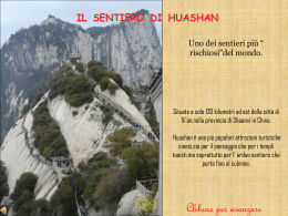
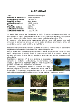
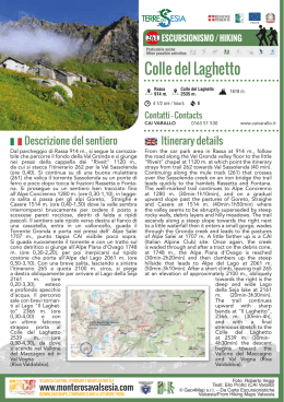
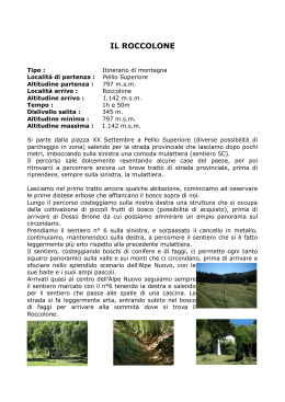
318 ESCURSIONISMO / HIKING
Praticabile anche
Other possible activities
Monte Tagliaferro
Rima
1411 m.
5 ore / hours
Monte Tagliaferro
2964 m.
EE
Contatti - Contacts
CAI VARALLO
Descrizione del sentiero
1553 m.
0163 51 530
www.caivarallo.it
Itinerary details
Si tratta del sentiero classico per la salita al Monte
Tagliaferro. Pur essendo la via normale, per
la ripidità, l'esposizione e la lunghezza è un percorso
da non sottovalutare, riservato ad escursionisti
esperti.
It is the common trail to ascend Monte Tagliaferro.
However, due to its steepness, exposition and length
it is quite challenging and therefore recommended
to expert hikers.
Dalla piazzetta della chiesa di Rima 1411 m. si esce
seguendo la mulattiera di sinistra che superando
il ponte lascia a sinistra il Museo Gipsoteca “Pietro
Della Vedova” e si prosegue per il colle del Piccolo
Altare prima, e per il Colle Mud poi, fino a quota
1700 m. circa (ore 0.45). Abbandonata la mulattiera,
si prende il sentiero che si stacca sulla sinistra,
attraversa il Rio Valmontasca, prosegue in piano fino
all'A. Scarpia di Sotto 1703 m. e successivamente
all'A. Scarpia di Sopra
1920 m. (ore 1.30).
Dall'alpeggio ci si
sposta
a
sinistra,
si guada il ruscello
proveniente dal Passo
del Vallarolo e si arriva
nei pressi di un grosso
masso
dal
quale
sgorga una sorgente
e sul quale è posta
una lapide. Attraverso
tratti con ontanelle,
pascoli
e
lastroni
si raggiunge il Passo
del Vallarolo 2332 m.
(ore 1-2.30), ampio
valico che comunica
con la Val Nonai.
Si lascia a sinistra il
From the little square of the church in Rima 1411 m.
follow the mule track to the left across the bridge
leaving “Pietro Della Vedova” Museum to the left
and proceed towards the colle del Piccolo Altare and
thenc Colle Mud ascending to an altitude of about
1700 m. (45min). Then get on the trail that strays
towards left and past the bridge over Rio Valmontasca, continues on flat land as far as Alpe Scarpia
di Sotto 1703 m. and Alpe Scarpia di Sopra 1920 m.
(1h30min).
Moving
westward from the
alpine pasture facing
the creek coming
from
Passo
del
Vallarolo you arrive
close to a big boulder
with a water spring
and
a
memorial
plaque.
Across
pastures and slabs
you will reach Passo
del Vallarolo 2332 m.
(1h-2h30min),
a
broad pass connecting with Val Nonai.
Leaving trail 319
to the left, proceed
SCARICA CARTINE, ITINERARI E MOLTO ALTRO SU
www.monterosavalsesia.com
DOWNLOAD MAPS, ITINERARIES AND A LOT MORE FROM
Foto: Roberto Veggi
Testi: Elio Protto (CAI Varallo)
© Geo4Map s.r.l. – Da Carte Escursionistiche
Valsesia/From Hiking Maps Valsesia
sentiero 319, si prosegue a destra (Ovest) su buone
tracce e si raggiunge un gigantesco macigno nero.
Il sentiero accentua la pendenza fino a portarsi sotto
la verticale di un ripidissimo pendio erboso,
lo si risale con stretti e ripidi tornanti e si guadagna
il Passo del Gatto 2730 m. (ore 1.15-3.45), aperto
tra il Dosso Grinner e le propaggini alte del Tagliaferro. Volgendo a nord-ovest (destra) si segue il sentiero che taglia il ripido fianco di erba e rocce e
raggiunge la cresta sud di rocce frantumate e sassi,
che si segue la cresta sud di rocce frantumate e sassi
che si segue fino alla vetta del Tagliaferro
2964 m. (ore 0.45-4.30).
towards the right (west) until a huge black boulder.
The trail goes upward steeply until below the vertical
of a very steep grassy slope and ascends it in narrow,
hairpin bends gaining Passo del Gatto 2730 m.
(1h15min-3h45min), open between Dosso Grinner
and the upper offshoots of Tagliaferro. Turning
towards north-west (to the right) follow the trail
cutting the steep hillside of grass and rock and then
you reach the south crest of crushed rocks and
stones you will reach the Tagliaferro summit 2964 m.
(45min-4h30min).
Dalla cima il panorama è estesissimo, spaziando
dal Bernina al Monviso, ma è particolarmente
interessante ammirare il vicino Monte Rosa e le vette
del Mischabel.
From up there you will enjoy a stunning, wide view
stretching from Bernina to Monviso, but above
all you can admire the nearby Monte Rosa and the
Mischabel summits.
Il percorso nella parte alta, dal Vallarolo alla vetta,
presenta difficoltà di rilievo per la lunghezza
e soprattutto per la ripidità del sentiero, a tratti
scosceso, scivoloso e molto esposto. È riservato
a persone che non abbiano problemi di vertigini
e con allenamento adeguato.
The upper leg of the route, from Vallarolo to the
peak, is quite challenging because of its length and
particularly for the steepness of the trail which
in some tracts is abrupt, slippery and very exposed.
It
is
recommended
to
recommended
to the experienced with no history of vertigo.
Il Tagliaferro è raggiungibile anche dal versante
opposto della montagna, il sentiero proveniente
dall’Alpe Campo e dalla Bocchetta della Moanda
parte da Alagna ma è più impegnativo di quello qui
descritto da Rima ancorché molto più panoramico.
La salita al Tagliaferro sul versante alagnese è stata
parzialmente attrezzata dal CAI di Alagna nei tratti
più esposti tra la Bocchetta della Moanda ed il Passo
del Gatto. Il sentiero tuttavia, spesso soggetto
a erosione valanghiva, presenta tratti molto esposti
e scivolosi, che sarebbe preferibile evitare in caso di
pioggia o forte umidità e nebbia.
The Tagliaferro can be reached also from the opposite mountainside. The trail from Alpe Campo and
Bocchetta della Moanda leaves from Alagna but
it is more arduous then the one from Rima although
much more panoramic.
SCARICA CARTINE, ITINERARI E MOLTO ALTRO SU
www.monterosavalsesia.com
DOWNLOAD MAPS, ITINERARIES AND A LOT MORE FROM
The ascent to Tagliaferro from Alagna has been
partly equipped by the CAI of Alagna along the most
exposed tracts between Bocchetta della Moanda
and Passo del Gatto. However the trail is often
subject to avalanche erosion and in some tracts
is very exposed and slippery. It would be preferable
to avoid it in case of rain or high humidity and fog.
Foto: Roberto Veggi
Testi: Elio Protto (CAI Varallo)
© Geo4Map s.r.l. – Da Carte Escursionistiche
Valsesia/From Hiking Maps Valsesia
Scarica