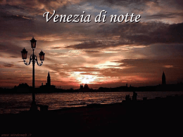
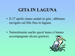
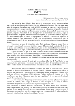
48
Dossier
Silvio Testa
Fig. 1 - 7. Navi da crociera nel centro storico di
Venezia
Cruise ships in the Venice city centre
Fig. 1
E le chiamano navi
And they call them Ships
Negli ultimi 15 anni il traffico croceristico è cresciuto a Venezia in maniera esponenziale: i passeggeri sono aumentati del 439 per cento e il numero delle toccate (gli attracchi delle navi) è passato da 206 nel 1997 a 655 nel 2011. Senza
contare i traghetti per la Grecia (351 toccate). Con un milione e 795 mila passeggeri imbarcati o sbarcati nel 2011, Venezia è diventata il primo “home port”
croceristico del Mediterraneo.
Le navi da crociera attraccano in Marittima, cioè in città, entrando e uscendo
dalla bocca di porto di Lido: ciò significa che a ogni toccata esse passano per
due volte in Bacino di San Marco e nel Canale della Giudecca, nel cuore storico
di Venezia, a 150 metri dal Palazzo Ducale. Il confronto è istruttivo: non si può
dire che le navi siano grandi come palazzi, perché lo sono molto di più: 300 e
più metri di lunghezza, 50 di larghezza, 60 d’altezza; stazzano migliaia di tonnellate. E aumenteranno ancora, di numero e di dimensioni. Il 2 giugno 2012 è
arrivata in Marittima la Msc Divina, la nave più grande mai entrata in laguna:
333 metri di lunghezza per 139 mila tonnellate di stazza lorda.
L’impatto visivo delle navi in Bacino è impressionante: sono evidentemente fuori scala con la città. Ma a chi ha cominciato a temere per il numero e la mole
crescenti delle navi è apparso chiaro che ci sono ben altri problemi di cui preoccuparsi, come ad esempio gli effetti idrodinamici provocati dal passaggio delle
navi su un tessuto urbano antico, fragile e delicato o sull’ambiente lagunare
(dislocano migliaia di tonnellate, quando passano l’acqua nei rii cala d’un colpo
di 20 e più centimetri per il risucchio).
Over the past 15 years, cruise traffic in Venice
has grown exponentially: the passengers have
increased by 439 per cent and the number of
arrivals has grown from 206 in 1997 to 655 in
2011. Without counting the ferries to Greece (351
arrivals). With 1,795,000 passengers embarked or
disembarked in 2011, Venice has become the number one cruise “home port” in the Mediterranean.
The cruise ships dock in the Marittima, in the
city, entering or leaving through the inlet of the
Lido: this means that for every arrival, a cruise
ship navigates twice through the Bacino di San
Marco and the Giudecca Canal, through the very
heart of the historic city 150 meters away from
the Ducal Palace. The comparison is instructive:
it’s not that the ships are as large as buildings,
they are much larger: over 300 meters long, 50
wide, 60 tall, with a tonnage of thousands. And
they are growing, both in number and size. On
June 12 2012 the Msc Divina docked at the Marittima, becoming the largest ship ever to enter the
lagoon: 333 metres long and a gross tonnage of
139 thousand tons.
The visual impact of the ships in the Bacino is
staggering: they are obviously out of scale with
the city. But to everyone who is nervous about the
growing number and size of the ships, it is clear
that there are many other problems to worry about
as well, such as for example the hydrodynamic
consequences of the cruise ships transiting through
this ancient, fragile and delicate urban fabric and
the danger to the lagoon environment (the ships
displace thousands of tons of water, and as they go
by the suction causes the water in the canals to fall
suddenly, 20 centimeters or more).
The greatest danger, which is usually not taken
into particular consideration, is to public health:
Arpav (the regional agency for environmental
protection) has demonstrated that cruise traffic
in Venice is the single greatest source of air pollution: the emission of fine particulates is practically
49
Dossier
Il rischio più grave, in genere poco considerato, è quello per la salute, dato che
l’Arpav (l’Agenzia regionale per la protezione ambientale) ha dimostrato che il
traffico croceristico è a Venezia la maggior fonte di inquinamento atmosferico:
l’emissione di polveri sottili è praticamente pari a quella prodotta dal traffico
automobilistico di Mestre, ogni nave inquina come 14 mila automobili, soprattutto quando è all’ormeggio.
Ricordo che il tenore di zolfo nel carburante di queste navi è dell’ 1,5% in navigazione (anche in laguna) e solo da poco dello 0,1% all’ormeggio. Tanto per
capire, il tenore di zolfo nel diesel delle automobili è dello 0,001%, cioè 1500
volte inferiore. Il parlamento europeo, dopo aver valutato che almeno 50 mila
persone muoiono ogni anno in Europa a causa dell’inquinamento delle navi,
ha votato a fine maggio 2012 una direttiva che imporrà per tutte le navi il limite
dello 0,5%, ma solo dal 2020. Già ora, nel Mar Baltico e nel Mare del Nord, tale
limite è dello 0,1%: la laguna di Venezia è di minor pregio?
Fig. 2
Il Porto garantisce che l’inquinamento verrà reso nullo all’ormeggio con l’alimentazione elettrica da terra (cold ironing). Al riguardo, sia chiaro, esiste solo uno studio
di fattibilità dell’Enel, non finanziato, per alimentare solo 4 navi delle 9 che a breve
la Marittima potrà ospitare, contro le 6 di oggi: ovvero, ammesso che il progetto sia
realizzato, l’inquinamento prodotto domani sarà identico a quello prodotto oggi.
Ci sono poi l’inquinamento elettromagnetico per i radar sempre accesi (e ci si
preoccupa per i telefonini) e quello marino per le pitture antivegetative delle carene; i rumori assordanti, giorno e notte, delle navi all’ormeggio praticamente a
equal to that produced by the automobile traffic in
Mestre: each ship pollutes as much as 14,000 cars,
especially when it is docked. It should be noted
that the sulphur content in the fuel used by these
ships is 1.5% when it is in navigation (even in the
lagoon) and only recently 0.1% when docked.
Just to get an idea, the sulphur content of diesel
in automobiles is 0.001%, 1500 times less. The
European Parliament assessed that almost 50,000
people die in Europe every year because of the
pollution caused by ships, and voted a directive
at the end of May 2012 that will establish a limit
of 0.5% for all ships, starting in 2020. In the Baltic
Sea and the North Sea, the limit is already 0.1%: is
the Venetian lagoon any less valuable?
of the 9 ships that the Marittima will soon be able
to host, compared to its current 6: this means that,
if and when the project is actually completed, the
pollution produced in the future will be identical to the pollution produced today. Then there
is the electromagnetic pollution caused by the
radars which are always on (and we worry about
cellphones!) and the water pollution caused by
the anti-fouling paint on the hulls; the deafening noise, day and night, of the ships docked at
wharves which are right near residential homes;
the vibrations that crumble the mortar bond in
homes and monuments; the danger of accidents
or –why not?- terrorist attacks in the Bacino San
Marco.
The Port guarantees that pollution will be eliminated by cold ironing along the wharves. On this
point however, and this should be clear, all there
is at the moment is a feasibility study developed
by Enel, without any funding, for powering 4 out
Citizens have begun to mobilize, and over the
years the Port Authority has tried to reassure
people with a series of self-acquitting studies that
are all guilty of bias. When carefully analyzed,
these studies are revealed to be partial, wanting,
50
Dossier
ridosso delle case; le vibrazioni che liquefano i leganti delle malte di case e monumenti; il rischio di incidenti o - perchè no? - di attentati in Bacino San Marco.
I cittadini hanno cominciato a mobilitarsi, e negli anni l’Autorità portuale ha cercato di rassicurare la gente con una serie di studi autoassolutori che hanno tutti
il difetto di essere di parte. Ad analizzarli con attenzione, gli studi sono parziali,
carenti, superficiali, come ho cercato di dimostrare nel libretto “E le chiamano
navi” (Corte del Fontego, Venezia 2011). Ad esempio, per quanto riguarda gli
effetti idrodinamici, l’Autorità Portuale ha strumentalmente continuato ad affrontare solo il tema del moto ondoso di superficie, spacciandolo in tutti i suoi
comunicati come l’unico problema, ma su quanto avviene su rive e fondali per
il dislocamento non esiste nulla, probabilmente non per caso. Si sa che l’Ismar
CNR ha analizzato alcuni aspetti del problema, ma i risultati non sono noti.
C’è poi l’impatto turistico: nel luglio 2011 da sei navi ormeggiate contemporaneamente in Marittima sono sbarcati in città in un solo giorno 35 mila croceristi, che si sono aggiunti ai 60 - 70 mila ospiti presenti quotidianamente in una
città il cui numero di abitanti è già sceso sotto la soglia dei 59 mila. Venezia
si sta trasformando (se non lo è già) in un parco tematico, ma se il turismo è
ricchezza, come dicono gli operatori, le compagnie di navigazione, l’Autorità
portuale, non si capisce come mai la città in quanto tale si stia spegnendo e il
Comune debba vendere i suoi più bei palazzi per garantire i servizi.
Fig. 3
Fig. 4
Lo stesso presidente dell’Autorità Portuale, Paolo Costa, in più occasioni riconosce che il contributo economico dei croceristi alla città è modesto, mentre
superficial, as I have tried to demonstrate in my
pamphlet “E le chiamano navi” (‘And they call
them ships’, published by Corte del Fontego,
Venice 2011). For example, in regards to the
hydro-dynamic consequences, the Port Authority
has continued in a biased way to talk about one
theme alone, wave motion on the surface, falsely
presenting this issue in all its press releases as
the only real problem, but what happens to the
embankments and the canal bottoms during the
ship’s transit is not addressed, and this is probably
deliberate. It is common knowledge that Ismar
CNR has analyzed several aspects of the problem,
but the results have not been made public.
Then there is the impact on tourism: on a single
day in July 2011, the six ships that were docked
in the Marittima disembarked 35 thousand cruise
ship tourists in the city, on top of the 60-70 thousand visitors that come every day to this city in
which the number of residents has dipped below
the threshold of 59,000.
The president of the Port Authority himself, Paolo
Costa, on several occasions recognizes that the
economic contribution of cruise ship tourists to
the city is quite modest, but he states that the true
wealth brought in by cruise ship tourism lies in the
downstream activities. But what are the figures
involved? Who makes the profit? What companies?
Where are they based? What capital do they have?
Where do the employees live? Because if the
answer to these questions reveals that part or most
of the money goes elsewhere, Venice would simply
be the cash cow, as usual.
Citizens and associations are wielding the battle axe, in a sequence of assemblies and press
releases; the Committee ‘No Grandi Navi – Laguna
Bene Comune’ (n.d.t: No Big Ships – Lagoon
51
Dossier
afferma che la vera ricchezza portata dal crocerismo sarebbe l’indotto. Ma quali
sono le cifre? Chi ne guadagna? Quali sono le società? Dove sono localizzate?
Quali ne sono i capitali? E dove vivono i lavoratori? Perché se le risposte a
queste domande lasciassero capire che una parte o molto dell’indotto vanno
altrove, Venezia farebbe (come al solito) solo la parte della mucca da mungere.
Cittadini e associazioni sono ormai sul piede di guerra, assemblee e comunicati si susseguono, da poco si è costituito in città il Comitato No Grandi Navi
– Laguna Bene Comune che ha già organizzato diverse manifestazioni, molto
partecipate. Il Comitato è postato in facebook e presto avrà un suo sito Internet
(www.nograndinavi.it), ma anche la sezione veneziana di Italia Nostra ha al
riguardo un sito attento e aggiornato, Ambiente Venezia ha prodotto un dossier
assai documentato sottoscritto da 2 mila cittadini e inviato a tutte le autorità, si
è mobilitato il Fai (Fondo per l’Ambiente Italiano). A oggi, quasi 7.000 cittadini
hanno firmato in soli 30 giorni una petizione che al primo punto chiede l’estromissione delle navi incompatibili dalla laguna (giugno 2012).
Fig. 5
Fig. 6
Il sindaco, Giorgio Orsoni, aveva dapprima proposto di spostare il terminal croceristico dalla Marittima a Marghera, in gronda di laguna, poi assieme al presidente dell’Autorità portuale, Paolo Costa, ha raggiunto un accordo incentrato
praticamente sull’idea di una sorta di “senso unico”: le navi, cioé, entrerebbero
dalla bocca di porto di Malamocco passando dal Canale dei Petroli e uscirebbero
da quella di Lido, dimezzando il numero dei transiti in Bacino San Marco. E’ la
proposta che i ministri Corrado Clini (Ambiente) e Corrado Passera (Infrastrutture) hanno tradotto nel decreto del 2 marzo 2012 sulla protezione dei siti marini
Public Property) has organized several protests in
which a large number of people participated. The
Committee is on Facebook and will soon have its
own Internet site (www.nograndinavi.it), but the
Venetian section of Italia Nostra also has a complete
and up-to-date website. Ambiente Venezia has
produced a well-documented dossier signed by two
thousand citizens and sent to all the authorities, the
Fai (Fondo per l’Ambiente Italiano, the environmental and landscape observation group) has begun
to take action. As of today (June 2012), in less than
thirty days almost 7000 citizens have signed a
petition, the first point of which demands that ships
incompatible with the lagoon be banned from it.
Mayor Giorgio Orsoni first proposed to move
the cruise ship terminal from the Marittima to
Marghera, along the edge of the lagoon, then with
the president of the Port Authority Paolo Costa,
he negotiated an agreement centred basically on
the idea of a sort of “one-way” route: the ships
would enter through the inlet of Malamocco,
navigate through the Canale dei Petroli and would
leave through the inlet of the Lido, cutting the
number of transits through the Bacino di San
Marco in half. This was the proposal that Ministers
Corrado Clini (Environment) and Corrado Passera
(Infrastructure) translated into the decree on the
protection of sensitive marine sites dated 2 March
2012, which also banned ships exceeding 500 tons
of gross tonnage: but for Venice, transit though
the Bacino di San Marco is only forbidden to ships
exceeding 40,000 tons of gross tonnage. Just to
give an idea, the tonnage of the battleship Roma
was 46,000 tons, and no one knows how this
“safety” limit was determined. Why, in any case
or even instead, is there never any reference to
displacement?
52
Dossier
sensibili, all’interno dei quali è vietata la navigazione alle navi che superino le 500
tonnellate di stazza lorda: per Venezia, però, si prevede il divieto del passaggio
in Bacino San Marco solo per le navi oltre le 40.000 tonnellate di stazza lorda.
Per capire, la corazzata Roma ne stazzava 46.000, e nessuno sa come sia stato
determinato questo limite di “sicurezza”. Perchè, in ogni caso e invece, non si
fa mai riferimento al dislocamento?
Questa alternativa, però, prevede lo scavo del piccolo canale Contorta Sant’Angelo che dalla profondità di 1,80 m. verrebbe portato a 10 m. e dalla larghezza
di 6 m. verrebbe portato a 70. Gli oppositori giudicano dunque la proposta peggiore del male, dato che portare le navi in Marittima dalla porta di servizio manterrebbe tutte le criticità e in primis l’inquinamento devastando definitivamente
la laguna. Per gli oppositori, insomma, le grandi navi, quelle incompatibili con
la città e con la laguna, vanno estromesse.
Al riguardo, serve una breve spiegazione. La laguna di Venezia è un ambiente
artificiale nel quale, per un millennio, gli interventi del governo della Serenissima
hanno sfruttato i fenomeni naturali per mantenerne l’equilibrio, garanzia di sopravvivenza della città. Il destino di ogni laguna, infatti, è interrarsi o divenire un
braccio di mare, ma se oggi Venezia è ancora in parte protetta dalla sua laguna
lo si deve appunto alle sagge politiche di conservazione attuate nei secoli passati
dai suoi reggitori, che hanno sempre dimensionato le navi alla laguna e mai viceversa. Caduta nel 1797 la Repubblica, saperi e attenzione ambientale si sono persi
e si è iniziato un lungo percorso di adattamento della laguna alle esigenze di una
moderna portualità che ha finito per rompere un delicato equilibrio e per devastarla. Le bocche di porto sono state allargate e approfondite, sono stati scavati
canali artificiali profondi e rettilinei, sono stati interrati migliaia di ettari di “barena” col risultato che oggi, se non fosse per la sopravvivenza del catino fisico e dei
cordoni dei lidi che la separano dal mare, non si potrebbe più parlare veramente
di laguna dal punto di vista morfologico, biologico, idrodinamico.
Il Canale dei Petroli è un cancro che ogni giorno divora la laguna, e con la proposta di senso unico Orsoni e Costa lo vogliono portare in Piazza San Marco. Al
riguardo, segnalo “Fatti e misfatti di idraulica lagunare”, del prof. Luigi D’Alpaos,
This alternative however requires excavation of
the little Canale Contorta Sant’Angelo, which from
a current depth of 1.80 meters would become
10 meters deep, and from a current width of 6
meters would be increased to 70. Opponents
therefore believe the proposal to be worse than
the problem, because bringing the ships into the
Marittima from the back entrance would leave
all the critical issues, first and foremost pollution,
unresolved and would definitively devastate the
lagoon. Opponents believe that the great ships
that are totally incompatible with the city and the
lagoon and should therefore be banned.
When the Republic collapsed in 1797, the knowledge and attention to the environment was lost,
and a long process began to adapt the lagoon to
the needs of a modern port, which in the long run
broke its delicate balance and devastated the lagoon. The inlets were dug wider and deeper, deep
linear artificial canals were dug, and thousands of
hectares of marshland were filled: the result is that,
were it not for the survival of the physical basin and
the strips of beaches that separate it from the sea,
the lagoon could no longer be really defined as
such from a morphological, biological and hydrodynamic point of view.
A brief explanation on the matter should be useful.
The Venetian lagoon is an artificial environment
which was shaped by the Most Serene Republic of
Venice, exploiting natural phenomena to maintain
a balance that guaranteed the survival of the city.
The fate of every lagoon is, in fact, to become filled
or develop into a branch of the sea, but if Venice is
still partly protected by its lagoon, this is due to the
wise conservation policies enacted in past centuries
by its keepers, who always sized the ships to fit the
lagoon and never vice-versa.
The Canale dei Petroli is a cancer that devours the lagoon every day, and with the proposal to turn it into
a one-way route Orsoni and Costa want to extend it
right up to Piazza San Marco. On this matter, I would
like to call attention to the publication “Fatti e misfatti
di idraulica lagunare” by Prof. Luigi D’Alpaos, professor of hydrodynamics at the University of Padua
(Istituto Veneto di Scienze Lettere e Arti, Memorie,
Venice 2010). One hundred years ago, the average
depth of the lagoon was 40 cm, now because of
the loss of sediment it is 1.50 m and in fifty years, if
nothing is done to restore its morphology, it will be
2.50 m. Hence it will no longer be a lagoon.
For over forty years, the special laws for Venice
(law n. 11 1973) have banned oil tankers from
the lagoon, but so far this has been ignored and
not until recently has the Port Authority launched
a project to create an ante-port on the open sea
for oil tankers and containers, though not for
environmental reasons, but simply to modernize
port facilities for new types of traffic and to reduce
the obstacles and delays potentially caused by the
“MOSE” to ships entering the lagoon. So where
there is a will there is a way. If cruise ships were
also banned, for the first time in over two hundred
years it would be possible to begin reversing the
damage to the lagoon, perhaps even closing the
Canale dei Petroli in the future, thereby removing
the causes of morphological damage as prescribed by the special laws (law n.798 1984).
Opponents to the above suggest a plan the
objective of which is to bar all ships from the
lagoon that are incompatible with the general
wellbeing of the city and the morphological
53
Dossier
docente di idraulica all’Università di Padova (Istituto Veneto di Scienze Lettere
e Arti, Memorie, Venezia 2010). Cent’anni fa, la profondità media della laguna
era di 40 cm., ora per la perdita di sedimenti è di 1,50 m. e tra cinquant’anni, se
non si porrà mano per davvero al suo recupero morfologico, sarà di 2,50 m. Cioé
non ci sarà più una laguna. Le leggi speciali per Venezia prescrivono da quasi
quarant’anni (legge n. 171 del 1973) l’estromissione almeno del traffico petrolifero
dalla laguna, ma finora non vi si è ottemperato e solo oggi, non per ragioni ambientali ma per adeguare la portualità a nuovi traffici e per temperare gli intralci
e i ritardi all’entrata delle navi in laguna che il “Mose” comporterà, l’Autorità
portuale ha lanciato il progetto dell’avamporto in mare aperto per i petroli e per i
container. Dunque, se si vuole si può. Se si estromettessero anche le navi da crociera, per la prima volta da duecento anni a questa parte si potrebbe cominciare a
pensare di invertire davvero il degrado della laguna, arrivando forse in futuro alla
chiusura del Canale dei Petroli, rimuovendo cioè le cause del dissesto morfologico così come prescritto dalle leggi speciali (legge n. 798 del 1984).
Chi si oppone a tutto ciò, suggerisce un percorso che ha per obiettivo l’estromissione dalla laguna delle navi incompatibili col complessivo benessere della
città e col recupero morfologico della laguna. La vera alternativa è cambiare modello, rifiutare la corsa al gigantismo che fa gli interessi solo delle compagnie
da crociera ma non della città. Si facciano studi seri, autorevoli, non di parte
per definire questa soglia di compatibilità, fondata su stazze, dislocamento,
pescaggio, carburanti puliti, e poi si fissi un limite di sostenibilità turistica complessiva assegnandone una quota invalicabile al crocerismo: indicate queste
due precondizioni – compatibilità fisica e sostenibilità turistica – si potrà decidere quali e quante navi potranno continuare a entrare in laguna e venire ad
attraccare in Marittima e quali e quante saranno destinate all’estromissione, e
solo allora sarà possibile, anche col sostegno di un attento studio costi – benefici, riempire di contenuto quel “fuori le navi dalla laguna”. Il range va dall’opzione zero (nessuna altra nave oltre a quelle che possono entrare), all’attracco in
altri porti e il trasferimento con altri mezzi dei croceristi a Venezia, al terminale
in mare aperto come per petroli, container e rinfuse.
regeneration of the lagoon. The real alternative
is to change models, to reject the pursuit of the
giant scale, which serves the interests of the
cruise ship companies but not those of the city.
In-depth authoritative, non-biased research studies should be conducted to define this threshold
of compatibility, based on tonnage, displacement, draught, clean fuel, and then establish a
limit of overall sustainable tourism that attributes
a binding share to cruise ships; once these two
pre-conditions – physical compatibility and
sustainable tourism – are established, a decision
can be made on which and how many ships
may continue to enter the lagoon and dock in
the Marittima, and which and how many must
be barred; only then will it be possible, with the
help of a serious study of the costs and benefits,
to give true content to the proposition to “ban
ships from the lagoon”. The range may vary from
zero-option (no other ship except those allowed
to enter), to docking in other ports and transportation of the cruise-ship tourists to Venice by
other means, to an open-sea terminal like the
oil-tankers, containers and bulk cargo.
Fig. 7
Scaricare