I Gentile cliente, grazie per aver scelto un prodotto TELE System. Se volete essere sempre informati su ultimi aggiornamenti, news e offerte speciali per il Vostro nuovo navigatore portatile TS 8.4 PND, registrateVi subito sul sito www.telesystem.it TS 8.4 PND SOMMARIO: Sommario:........................................................................................................................................I Norme di sicurezza ........................................................................................................................ 1 Installazione ................................................................................................................................... 4 Tasti e connessioni .................................................................................................................... 4 Collegamento PND al PC ........................................................................................................ 11 Accensione .............................................................................................................................. 12 Navigazione ................................................................................................................................. 13 Destinazione ............................................................................................................................ 13 Favoriti ..................................................................................................................................... 19 Opzioni..................................................................................................................................... 21 Modalità di navigazione ........................................................................................................... 25 Navigazione ............................................................................................................................. 25 Pianificazione di un itinerario................................................................................................... 27 Funzioni opzionali ........................................................................................................................ 29 Avviso di autovelox .................................................................................................................. 29 Domande frequenti....................................................................................................................... 30 I TS 8.4 PND NORME DI SICUREZZA Per un utilizzo sicuro dell’apparecchio, e per la vostra incolumità, vi preghiamo di leggere attentamente i seguenti consigli riguardanti le misure di sicurezza. VARIE x Il produttore declina ogni responsabilità per danni a cose e/o persone derivanti da un utilizzo improprio del prodotto TS8.4 PND o legati al mancato rispetto delle avvertenze e delle note inserite nella documentazione tecnica. x L’uso del navigatore implica l’accettazione e l’osservanza del contenuto del presente manuale. x Il produttore non risponde in caso di eventuali violazioni al codice stradale legate all’uso del prodotto. x I dati cartografici immagazzinati nel navigatore potrebbero presentare discrepanze rispetto agli itinerari reali. Ciò è dovuto ai continui cambiamenti nella morfologia stradale. Alcune zone sono inoltre caratterizzate, per diversi motivi, da una copertura cartografica maggiore rispetto ad altre. INSTALLAZIONE x Installare il dispositivo a veicolo fermo ed in condizioni di sicurezza. x Installare il dispositivo in modo da non ostruire la visibilità del guidatore e da non causare pericoli in caso di incidente. x Controllare che il dispositivo non interferisca con gli airbag o altri dispositivi di sicurezza del veicolo. x Assicurarsi che il dispositivo sia ben fissato al supporto prima di partire. x TELESystem non risponde di nessun eventuale danno causato dall’utente nell’ installazione e disinstallazione del TS8.4 PND sul veicolo DURANTE LA GUIDA x Il conducente del veicolo è responsabile dell’utilizzo del TS8.4 PND nelle corrette modalità di funzionamento. x L’utente deve ignorare le indicazioni fornite dal TS8.4 PND nel caso queste risultino in contrasto con il codice della strada. x Non affidarsi esclusivamente alle indicazioni vocali. Queste potrebbero risultare non corrette o non tempestive. Considerare sempre le informazioni fornite come indicative e rispettare la segnaletica stradale. x I navigatori satellitari forniscono un semplice ausilio alla guida e all’orientamento. La corretta guida e la scelta del percorso migliore spettano sempre al conducente del veicolo. x Durante il viaggio è possibile ricevere informazioni vocali del tipo: ‘’Tenere la destra’’ oppure ‘’Tra 300 metri gira a destra’’; queste indicazioni derivano da dati cartografici che a volte possono risultare poco pertinenti con la strada che si sta percorrendo. Porre particolare attenzione in prossimità di rotonde o grandi incroci: le indicazioni vocali potrebbero non essere semplici. 1 TELE System Non distrarsi durante la guida per consultare il navigatore se questo comporta pericolo per voi o per gli altri. x Per consultare il navigatore fermarsi non appena possibile e quindi agire sui comandi del navigatore. x Effettuare le operazioni manuali sul navigatore esclusivamente a veicolo fermo. x La precisione della posizione GPS, in condizioni di ricezione ottimale del segnale, è garantita con uno scarto di circa 15 metri. ALIMENTAZIONE x È possibile alimentare il navigatore collegandolo tramite l’adattatore da auto alla presa accendisigari dell’auto o tramite cavo USB al PC. x Utilizzare solo ed esclusivamente i cavi forniti in dotazione. x Non aprire il navigatore. All’interno dell’apparecchio possono essere presenti tensioni superiori a quella di alimentazione che potrebbero mettere a repentaglio la sicurezza dell’utente. L’alta tensione è presente anche quando l’apparecchio è in modalità standby, prima di intervenire sul dispositivo è necessario scollegarlo dalla rete elettrica. La rimozione non autorizzata del coperchio farà decadere immediatamente la garanzia! CAVO DI ALIMENTAZIONE DA AUTO x Prima di installare l’apparecchio controllare l’integrità del cavo. Inoltre controllare il connettore per la presa dell’auto e la connessione al navigatore. In caso il cavo in qualche sua parte risultasse danneggiato, non collegare l’apparecchio e sostituire il cavo. x In caso di danneggiamento del cavo durante l’utilizzo, scollegare con attenzione l’apparecchio dalla presa dell’auto e rivolgersi esclusivamente a personale specializzato o al centro assistenza per la sostituzione. LIQUIDI x Tenere il navigatore lontano da qualsiasi tipo di liquido. x 2 TS 8.4 PND L’apparecchio non deve essere installato in luoghi in cui possa venire a contatto con spruzzi o schizzi di liquidi o in ambienti con alto tasso di umidità dove possano formarsi condense. x Nel caso in cui il navigatore venga accidentalmente in contatto con liquidi, togliere immediatamente l’alimentazione. NON TOCCARE il navigatore con le mani prima che sia stato scollegato. PULIZIA x Prima di procedere ad operazioni di pulizia, staccate l’alimentazione. x Per pulire l’esterno del navigatore, usare un panno morbido e asciutto. Evitare l’uso di prodotti chimici o solventi. ATTENZIONE! x Tenere l’apparecchio fuori dalla portata dei bambini. x I sacchetti di plastica degli imballaggi possono essere pericolosi. Per evitare soffocamenti, tenere i sacchetti lontani dalla portata dei bambini. x In caso di utilizzo del dispositivo in presenza di temperature molto elevate potrebbe entrare in funzione un meccanismo di protezione interna che provvede allo spegnimento automatico. Tale meccanismo è necessario per la sicurezza dell’utente e per la salvaguardia della batteria del dispositivo. x Non disperdere il prodotto nell’ ambiente per evitare potenziali danni per l’ ambiente stesso e la salute umana e per facilitare il riciclaggio dei componenti/materiali contenuti in esso. Chi disperde il prodotto nell’ambiente o lo getta insieme ai rifiuti comuni è sanzionabile secondo il D.Lgs.22/1997. x Il produttore istituisce un sistema di recupero dei RAEE del prodotto oggetto di raccolta separata e sistemi di trattamento avvalendosi di impianti conformi alle disposizioni vigenti in materia. x Portare il prodotto non più utilizzabile presso un centro di raccolta autorizzato a gestire rifiuti di apparecchiature elettriche ed elettroniche in quanto non può essere unito ai rifiuti comuni, oppure è sempre possibile riconsegnare allo stesso distributore l’apparecchiatura usata o a fine vita all’atto dell’acquisto di una nuova di tipo equivalente. ATTENZIONE! TELE System Srl comunica, che a seguito di eventuali modifiche software e/o hardware aventi l’obiettivo di migliorare il prodotto, si potrebbero evidenziare leggere incongruenze tra il contenuto di questo manuale ed il prodotto in possesso. x 3 TS 8.4 PND INSTALLAZIONE Tasti e connessioni Frontale 1. Touch Screen 2. Led indicazione caricamento batteria 4 TS 8.4 PND Posteriore 3. 4. 5. 6. RESET Connessione modulo antenna esterna GPS Pennino Touch Screen Altoparlanti ATTENZIONE! Utilizzando il tasto RESET verranno cancellate personalizzate e ricaricate le impostazioni di fabbrica. tutte le impostazioni 5 TELE System 7. 8. 9. 10. 11. 6 Tasto on/off Connessione usb Slot card SD/MMC Connessione jack cuffie audio Connessione alimentatore per auto TS 8.4 PND Carica della Batteria Alla prima accensione il dispositivo potrebbe non avere la batteria completamente carica, si consiglia, comunque, di effettuare un ciclo completo di carica prima dell’utilizzo del navigatore. Per caricare la batteria collegare il navigatore con l’adattatore da auto all’ingresso Alimentazione DC sul lato inferiore del PND. ATTENZIONE! Per allungare la vita della batteria si consiglia di non caricarla ad alta temperatura (il dispositivo è comunque dotato di una protezione interna contro le temperature eccessive). Non è necessaria scaricare completamente la batteria prima di effettuare la ricarica. E’ possibile utilizzare la connessione USB per effettuare la carica della batteria. Utilizzare esclusivamente il cavo presente della confezione, previo controllo della sua integrità. In tal caso il pc deve essere alimentato ed acceso. Per l’utilizzo con adattatore auto e proteggere il PND dalle eventuali sovratensioni generate dall’impianto elettrico dell’auto durante l’accensione, si consiglia di collegare il cavo a motore già acceso. 7 TELE System Uso del PND in Auto Installazione del nuovo Air Mount Support (NEW) TELESystem è lieta di proporti un innovativo sistema di installazione per il tuo nuovo navigatore TS8.4 PND. Tale supporto ti consentirà una guida più comoda e rilassante, dandoti la completa visibilità sul parabrezza. Inoltre ti eviterà problemi per i sempre più frequenti furti, non essendo alla vista dei malintenzionati. Di seguito ti illustriamo come procedere alla facile installazione del supporto. Fig. A) Staccare gli agganci mobili posteriori, spostandoli verso l’interno. Poi posizionarli a piacere. Consigliamo di utilizzare l’ultima scalanatura Fig. C) Premere delicamente sull’aletta superiore della bocchetta prescelta 8 Fig. B) Procedere all’inserimento come da figura, scegliendo la bocchetta a destra o sinistra del guidatore Fig. D) Continuare a premere finchè si sente il click degli agganci TS 8.4 PND Fig. E) Spostare verticalmente i morsetti mobili superiori per una migliore stabilità Fig. F) Posizionare adeguatamente la leva mobile inferiore per una migliore stabilità e ergonomia Fig. G) Agganciare il tuo navigatore TS8.4 PND con gli appositi attacchi della mascherina in dotazione Ora sei pronto a goderti il tuo nuovo TS8.4PND in modo sicuro e comodo. Buona navigazione! ATTENZIONE! Il dispositivo è stato testato in modo approfondito e ripetutamente in condizioni di guida normali. Si consiglia comunque di spegnere o limitare l’afflusso di aria calda/fredda nella bocchetta d’aria prescelta. Ti spieghiamo ora come sganciare il supporto. Consigliamo di eseguire questa operazione solamente in caso di assoluta necessità. 9 TELE System Fig. H) Dopo aver staccato il tuo TS8.4 PND, spingere verso all’interno un aggancio Fig. L) Staccare completamente la base del supporto Fig. I) Staccare l’aggancio dalla base del supporto e ripetere l’operazione della fig. H) per l’altro aggancio Fig. M) Staccare entrambi gli agganci dalla bocchetta dell’aria Si ricorda che la migliore posizione dell’antenna GPS per la ricezione del segnale antenna GPS è quella parallela al terreno. ATTENZIONE! Se il cristallo dell’auto è schermato, il dispositivo può avere difficoltà ad agganciare il segnale GPS, in questo caso si consiglia l’utilizzo di un’antenna GPS esterna. 10 TS 8.4 PND Collegamento PND al PC È possibile collegare il PND direttamente al vostro PC tramite la porta. Perché il PND venga riconosciuto dal PC, è necessario che nel vostro PC sia installato Microsoft® ActiceSync® che permette la sincronizzazione tra il PC ed i dispositivi basati su Window Mobile quale il vostro PND. Una volta collegato il PND verrà visualizzato come Mobile Device in Risorse di Sistema e la SD card verrà vista come una cartella SDMMC. Salvare eventuali file solo in questa cartella. Non modificare il contenuto delle altre cartelle visualizzate in Mobile Device per evitare di danneggiare la SD Card ed il funzionamento del PND. E’ consigliabile effettuare gli eventuali aggiornamenti per il vostro navigatore tramite un semplice lettore di SD Card. Inserite la SD card nello slot del lettore e scaricate direttamente in essa il software certificato che trovate in www.telesystem.it . In questo modo l’aggiornamento del vostro 8.4PND avviene in modo veloce e sicuro. Premere il tasto RESET per rendere operativi gli aggiornamenti fatti. 11 TELE System Accensione Impostazioni Iniziali Alla prima accensione portare l’interruttore in posizione ON, dopo qualche secondo comparirà la schermata di caricamento Se non dovesse avviarsi il software di navigazione, verificare che la SD card inserita contenga i file corretti; inoltre se non dovesse essere presente l’audio, verificare il livello di batteria, se questo dovesse essere basso, ricaricare la batteria e riavviare il PND. Durante la navigazione, nella parte superiore della schermata compare l’indicatore dello stato della batteria. ATTENZIONE! In caso di sporadici e casuali blocchi o errori generici di sistema, effettuare un RESET del dispositivo. ATTENZIONE! Estraendo e reinserendo la SD card durante l’utilizzo del navigatore, non è più garantita la sua corretta funzionalità. In caso, effettuare un RESET. 12 TS 8.4 PND NAVIGAZIONE Accendere il dispositivo, posizionarlo con una visuale libera verso l'alto e stabilire un primo collegamento via satellite. In auto è consigliabile fissare il dispositivo al parabrezza con il supporto in dotazione. ATTENZIONE! In occasione del primo collegamento, o se il dispositivo viene riacceso in una zona diversa da quella in cui è stato spento, la ricerca dei satelliti GPS può richiedere diversi minuti. Dopo il caricamento dell'applicazione, verrà visualizzata una schermata in cui sono illustrate alcune norme di sicurezza. Leggerle attentamente. In seguito, sarà possibile scegliere di non visualizzarle all'avvio successivo. Verrà, quindi, visualizzato il menù di navigazione: Destinazione Questa sezione permette all’utente del PND di impostare la destinazione dell’itinerario o eventuali tappe desiderate. Ricerca per Indirizzo La Ricerca di indirizzo consente di individuare un indirizzo tramite l'immissione di informazioni sulla destinazione desiderata (quali la via, il paese o la città). Sarà quindi possibile selezionare uno dei risultati visualizzati in un elenco e utilizzare l'indirizzo per diversi scopi, ad esempio per individuare la destinazione su una mappa, per pianificare l'itinerario e per la navigazione. x Sullo schermo selezionare l'icona del menu finestra Indirizzo: . Verrà visualizzata la 13 TELE System x Immettere i dati appropriati per individuare l'indirizzo desiderato. Modalità di ricerca Il dispositivo personale di navigazione offre una funzione di ricerca pratica e interattiva con completamento automatico della digitazione per evitare errori di ortografia. È possibile premere solo i pulsanti che consentono di ottenere risultati di ricerca. Tutti gli altri pulsanti sono disattivati. x Immettere il primo carattere. Alcuni pulsanti sulla tastiera verranno disattivati e sarà possibile scegliere solo i pulsanti attivi: x Immettere il secondo carattere. In base alla scelta effettuata, alcuni pulsanti verranno disattivati. x Continuare a immettere caratteri fino a limitare la ricerca a un unico risultato. OPPURE x Premere l'icona di ricerca Verrà visualizzato un elenco di risultati. x 14 Scegliere la voce desiderata dall'elenco. TS 8.4 PND Per passare dalla modalità alfabetica a quella numerica, premere 123 o ABC. Per passare dai caratteri maiuscoli a quelli minuscoli, premere ^. Se in qualsiasi momento si desidera cancellare un carattere digitato, premere il pulsante Indietro <í sulla schermata. Per aggiungere uno spazio, premere il pulsante _. Impostazione del Paese Per selezionare il Paese desiderato premere Paese. Scegliere il Paese dall'elenco. Il campo Paese verrà compilato con il nome del Paese selezionato. Immissione di un codice postale Invece del nome di una città è possibile utilizzare anche un codice postale. Per immettere un codice postale, premere Centro CAP Il database NON contiene i CAP di tutte le località. x Immettere il codice postale del paese o della città che si sta cercando. x Premere l'icona di ricerca (lente di ingrandimento). Verrà visualizzato un elenco di risultati. Scegliere il paese o la città desiderata dall'elenco. Verrà visualizzata la schermata Indirizzo, I campi Città e Centro CAP verranno compilati con la città e il codice postale selezionati. È inoltre possibile immettere un codice di avviamento postale univoco a 7 cifre. In questo caso non è necessario immettere una via. Ricerca della città x Per selezionare la città desiderata premere Città. x Cercare la città in base alla procedura illustrata in precedenza. Verrà visualizzato un elenco di risultati. Scegliere il paese o la città desiderata dall'elenco. Verrà ri-visualizzata la schermata Indirizzo ed il campo Città verrà compilato con il nome del paese o della città selezionata. Ricerca della via x Per immettere la via, selezionare Via. 15 TELE System x Cercare la via in base alla procedura illustrata in precedenza. Verrà visualizzato un elenco di risultati. Scegliere la via desiderata dall'elenco. Nota: non digitare la parola “Via” ma scrivere solo una parola che compone il nome della via. Esempio: Via S. Benedetto Æ scrivere “Benedetto” ed avviare la ricerca. Verrà ri-visualizzata la schermata Indirizzo, compilata con i dati individuati. È possibile immettere anche il numero civico, tuttavia, è possibile che non tutti i numeri civici risultino disponibili. Impostazione di un itinerario in base a un indirizzo specifico Dopo aver limitato la ricerca a un indirizzo univoco, è possibile avviare la navigazione. Premere . Sarà quindi possibile scegliere di essere condotti a tale indirizzo, di utilizzarlo per la pianificazione dell'itinerario e salvare l’indirizzo o visualizzarlo sulla mappa: x Premere Naviga per impostare un itinerario in base alla località specificata x Premere Tramite per utilizzare la località per l'itinerario. x Premere Salva per salvare la località tra i Favoriti. x Premere Sulla mappa per visualizzare la località sulla mappa. Ricerca e selezione dei punti di interesse La funzione Ricerca PdI consente di individuare rapidamente i punti di interesse nelle vicinanze, quali aree di servizio e ristoranti, scelti da un database di milioni di punti di interesse situati nelle vicinanze o in località distanti. x Nel menù di navigazione selezionare Destinazione. x Selezionare Ricerca PdI . Verrà visualizzato un menu contenente le categorie dei punti di interesse: 16 TS 8.4 PND Nel campo Dove? situato in alto sulla schermata, viene visualizzata la località dalla quale si avvierà la ricerca. La località potrà essere scelta: x Premere Ricerca Indirizzo per impostare la località tramite l’indirizzo x Premere Favoriti per impostare la località tra quelle salvate tra i favoriti. x Premere Pos. GPS per impostare l’attuale posizione come località per la ricerca. Selezione di un punto di interesse x Selezionare la categoria dei punti di interesse desiderata. Verrà visualizzato un menu contenente delle sottocategorie. x Sceglierne una. Verrà visualizzato un elenco dei punti di interesse. Per selezionare un punto di interesse, è sufficiente toccarlo. x Premere Naviga per impostare un itinerario in base alla località specificata x Premere Tramite per utilizzare la località per l'itinerario. x Premere Salva per salvare la località tra i Favoriti. x Premere Sulla Mappa per visualizzare il punto di interesse desiderato. Ricerca dettagliata all'interno di una categoria Una volta selezionata la categoria, anziché scegliere una voce presente nella lista è possibile effettuare una ricerca più dettagliata: premere l'icona di ricerca .Si entra nella modalità di ricerca tramite Filtro. Nella finestra di ricerca immettere un termine da cercare (almeno tre caratteri) e avviare la ricerca premendo l'icona corrispondente (freccia a destra). Esempio: se si sta cercando un determinato museo, scrivere “MUS” nella finestra di ricerca del filtro. Verrà visualizzato l'elenco dei risultati. Per selezionare una località, è sufficiente toccarla. Mappa Utilizzo della mappa La mappa è il componente principale del dispositivo personale di navigazione. Per impostazione predefinita, verrà centrata sulla posizione corrente del navigatore, a condizione che sia disponibile una connessione GPS. È possibile 17 TELE System esplorare la mappa, ottenere informazioni sulle diverse località visualizzate e perfino sceglierle per l'itinerario e la navigazione. Dal menù Destinazione, toccando , si accederà alla mappa in modalità visualizzazione/selezione (v/s), nella quale è possibile esplorare a piacere la mappa, senza che la stessa rimanga centrata sulla posizione attuale del navigatore. Per esplorare la mappa, utilizzare un dito o una penna dedicata (per touch screen). La posizione corrente sarà identificata da un cursore. Per ingrandire o ridurre la visualizzazione, premere l'icona + o -. Verrà visualizzato il cursore dello zoom, che può essere utilizzato per ingrandire o ridurre gradatamente la visualizzazione. L'icona Bussola (nell'angolo inferiore sinistro) consente di regolare l'orientazione della mappa. x Per tornare alla modalità navigazione (t/n), premere l'icona corrispondente nell’angolo inferiore sinistro. x Per uscire dall'applicazione, premere il pulsante . Selezionare il punto sulla mappa desiderato e premendo l’icona nell’angolo inferiore destro la navigazione: x , sarà possibile gestire il punto evidenziato dal cursore per Premere Naviga per impostare un itinerario in base alla località specificata x Premere Tramite per utilizzare la località per l'itinerario. x Premere Salva per salvare la località tra i Favoriti. x Premere Ricerca per avviare una ricerca per punti di interresse (POI) x Premere Opzioni per modificare le impostazioni della mappa. 18 TS 8.4 PND Recente Nel menu principale, premendo Recente verrà visualizzato un elenco contenente le destinazioni visitate o cercate di recente. Sul display verrà visualizzato l'elenco degli oggetti recenti. Usare le frecce SU e GIÙ per scorrere l'elenco. Per selezionare un elemento, è sufficiente toccarlo, quindi sarà possibile: x Premere Naviga per impostare un itinerario in base alla località specificata. x Premere Tramite per utilizzare la località per l'itinerario x Premere Salva per salvare la località tra i Favoriti x Premere Sulla mappa per visualizzare la località sulla mappa principale. Favoriti È possibile impostare e gestire le destinazioni preferite o quelle più utilizzate, scegliendo tra l'indirizzo di casa o del posto di lavoro, un insieme di favoriti e i luoghi visitati di recente. L'elenco dei Favoriti contiene le destinazioni salvate come Favoriti. Ciò significa che non è necessario eseguire una nuova ricerca per tali destinazioni. x Premere Favoriti. Sul display verrà visualizzato l'elenco dei Favoriti: 19 TELE System Usare le frecce SU e GIÙ per scorrere l'elenco. Per selezionare un elemento, è sufficiente toccarlo. Una volta selezionato sarà possibile: x Premere Naviga per impostare un itinerario in base alla località specificata. x Premere Tramite per utilizzare la località per l'itinerario x Premere Ordinare permette di riordinare la lista x Premere Sulla mappa per visualizzare la località sulla mappa principale. x Premere Cancella per cancellare l’elemento selezionato dalla lista Favoriti x Premere Edita selezionato permette di rinominare l’elemento x Premere Cancella tutti per cancellare l’intera lista Favoriti. Recente L'elenco Recente contiene le destinazioni visitate recentemente. Ciò significa che non è necessario eseguire una nuova ricerca per tali destinazioni. x Premere Recenti. Sul display verrà visualizzato l'elenco dei Favoriti. Usare le frecce SU e GIÙ per scorrere l'elenco. Per selezionare un elemento, è sufficiente toccarlo. Una volta selezionato sarà possibile: x Premere Naviga per impostare un itinerario in base alla località specificata. x Premere Tramite per utilizzare la località per l'itinerario x Premere Ordinare permette di riordinare la lista x Premere Sulla mappa per visualizzare la località sulla mappa principale. x Premere Cancella per cancellare l’elemento selezionato dalla lista Favoriti x Premere Edita selezionato permette di rinominare l’elemento x Premere Cancella tutti per cancellare l’intera lista Favoriti. Viaggi Agendo sull’icona Viaggi 20 verranno visualizzati gli itinerari salvati. TS 8.4 PND Personali Questa funzione permette di archiviare gli indirizzi personali (casa e posto di lavoro) per poter gestire ed organizzare itinerari nel modo più rapido possibile. Se non è stato impostato alcun indirizzo, verrà richiesto di eseguire questa operazione. È possibile sceglierlo eseguendo la ricerca di un indirizzo, tramite la posizione GPS corrente oppure selezionando un luogo visitato di recente. Una volta impostato, ad esempio Casa, agendo sull’icona, sarà possibile: x Premere Naviga per impostare un itinerario in base alla località specificata. x Premere Modifica permette di rinominare l’elemento x Premere Cancella per cancellare l’elemento selezionato. x Premere Sulla mappa per visualizzare la località sulla mappa principale. x Premere Tramite per utilizzare la località per l'itinerario x Premere Cancella tutti per cancellare entrambi gli indirizzi personali Opzioni È possibile configurare il dispositivo personale di navigazione in base alle proprie esigenze. Durante la navigazione, ad esempio, è possibile scegliere di utilizzare o meno strade a pagamento o traghetti oppure selezionare la modalità di trasporto desiderata (automobile veloce o lenta, moto, a piedi e così via). È inoltre possibile modificare diverse opzioni di visualizzazione, ad esempio la modalità 2D o 3D, la modalità Giorno o Notte, il grado di complessità della mappa e così via. Selezionare Opzioni, comparirà sullo schermo il menù: Impostazioni generali Selezionare Imp.generali per modificare le impostazioni generali del PND, verrà visualizzata la finestra contenente le varie opzioni: 21 TELE System È possibile attivare/disattivare la funzione Autovelox, selezionare Impost. ora per cambiare il vostro fuso orario, scegliere l'Unità di misura della distanza (miglia/km). L’ora viene impostata automaticamente tramite il GPS. Scegliere Lingua per selezionare la lingua che verrà utilizzata nel sistema di navigazione. Una volta scelta la lingua, se disponibili, potrà essere scelto anche il tipo di lingua (maschile o femminile). E’ inoltre possibile controllare la Versione sw , settare la Retroilluminazione dello schermo e la Calibrazione del touch. Opzioni mappa Scegliere Opzioni mappa per modificare le opzioni della mappa. Verrà visualizzata la finestra contenente le opzioni della mappa: 22 TS 8.4 PND Per scegliere il tipo di elementi da visualizzare sulla mappa, selezionare Info mappa: Per visualizzare determinate categorie sulla mappa, selezionare le caselle corrispondenti. Deselezionare invece quelle corrispondenti a categorie che non devono essere visualizzate. Per passare dalla modalità Notte alla modalità Giorno e viceversa, premere l'icona corrispondente. Se selezionate Automatico, la modalità verrà scelta a seconda dell’ora corrente. Scegliere Mappe per selezionare una mappa. Se nella scheda di memoria sono disponibili mappe di altre regioni o città, toccare il nome della regione desiderata (ad esempio, Iberia). Verranno elencate tutte le mappe disponibili sulla scheda di memoria. Per scegliere la regione desiderata sarà sufficiente toccare il nome corrispondente. Per passare dalla modalità 2D alla modalità 3D e viceversa, premere l'icona corrispondente. Scegliere Direz. auto Su per ottimizzare l'orientazione della mappa durante la navigazione. Scegliere Nord Su per mantenere l'orientazione della mappa verso il Nord. Premere l’icona di conferma l'icona della freccia per applicare le vostre impostazioni, invece per tornare alla schermata precedente. Opzioni itinerario Selezionare Opzioni itinerario per modificare le opzioni dell'itinerario. Verrà visualizzata la finestra contenente le opzioni dell'itinerario: 23 TELE System Per passare da una modalità all'altra, è sufficiente toccare le icone. Queste verranno attivate, rendendo facilmente visibili le impostazioni attive. È possibile scegliere tra le seguenti opzioni: modalità di trasporto (automobile veloce o lenta, motocicletta, a piedi e così via), percorso più veloce o più breve, utilizzo o meno di strade a pagamento, autostrade e traghetti. ATTENZIONE! Ad esempio, la London Congestion Zone, nel centro della città, è considerata una strada a pagamento in quanto soggetta a tassazione. Pertanto, se si sceglie di evitare le strade a pagamento, non si verrà condotti in questa zona. Tuttavia, non verrà inviato alcun avviso se si entra in tale zona accidentalmente. Dopo aver scelto le opzioni desiderate, premere l'icona di conferma per tornare al Menù principale. Modalità di trasporto: panoramica Veloce: presuppone una guida veloce sulla strada. Se viene selezionata questa opzione, nella scelta dell'itinerario verranno favorite le autostrade. Lento: presuppone una guida più lenta sulla strada. Se viene selezionata questa opzione, nella scelta dell'itinerario verranno evitate le autostrade. Bici: vengono prese in considerazione le piste ciclabili e viene bloccata la scelta di autostrade, poiché le biciclette non possono circolarvi. Moto: se applicabili, vengono prese in considerazione le limitazioni per le moto. Motorino: se applicabili, vengono prese in considerazione le limitazioni per i motorini. Bus: se applicabili, vengono prese in considerazione le limitazioni per i bus. Pedonale: vengono forniti itinerari per i pedoni, incluso l'accesso completo alle strade a senso unico e alle aree pedonali, se presenti. 24 TS 8.4 PND Volume Scegliere Volume per impostare il volume della voce guida ed eventualmente escluderlo. (“Silenzio”) Modalità di navigazione Nella modalità di navigazione (t/n), la mappa segue la posizione corrente del navigatore (posizione GPS), visualizzando le informazioni sulla posizione geografica, la velocità e così via: Navigazione Le eccezionali funzionalità di navigazione di smart2go™ consentono di arrivare dal punto A al punto B in base al percorso più breve o più veloce, fornendo anche comandi vocali e una visualizzazione 3D. In questa sezione viene descritta la funzionalità di navigazione. Selezionare una località sulla mappa oppure tramite Destinazione, quindi premere Naviga nel relativo menù. La località verrà visualizzata sulla mappa di navigazione e il dispositivo calcolerà il percorso che verrà visualizzato la schermata di navigazione. Schermata di navigazione Sulla schermata di navigazione, l'itinerario verrà visualizzato in blu. La freccia rossa indicherà la direzione della manovra successiva, mentre i puntatori segnaleranno la posizione corrente. In prossimità di una svolta o di un altro tipo di manovra, verrà riprodotto un comando vocale al momento opportuno. Nelle strade a senso unico, la direzione di transito è indicata con una freccia rossa. 25 TELE System È possibile esplorare la mappa anche durante la navigazione. Ciò consente di selezionare una nuova destinazione se si desidera modificare l'itinerario. La navigazione non verrà interrotta e continueranno a essere forniti comandi vocali. Per seguire di nuovo l'itinerario sulla schermata, premere l'icona Indietro. premendo sull’icona navigazione: e potrete quindi selezionare insieme di opzioni di Alternativa Questa opzione consente di bloccare l'itinerario elaborato in base a una distanza specificata (ad esempio 0,5 km) e di utilizzarne uno alternativo. È sufficiente toccare l'icona che indica la distanza desiderata. L'itinerario verrà elaborato di nuovo e quello precedente per la distanza specificata verrà annullato. Itenerario Consente di visualizzare i punti di passaggio lungo l'itinerario. Salva Consente di salvare la posizione corrente tra i Favoriti. Volume Premere Volume per modificare il volume della voce guida. Ricerca Consente di reimpostare il proprio percorso scegliendo un punto di interesse (POI), ad esempio un'area di servizio. Opzioni x x Premere Opzioni mappa per modificare le impostazioni della mappa. Premere Opzioni di Guida per modificare le opzioni di guida. x Premere Imp.generali per modificare le impostazioni del PND 26 TS 8.4 PND Tutte le informazioni quali Opzioni, Favoriti e luoghi visitati di recente verranno memorizzate sulla scheda di memoria e non sul dispositivo. Pianificazione di un itinerario In questa sezione viene descritta la funzione di pianificazione dell'itinerario. Questa funzione consente di pianificare il proprio itinerario in anticipo, impostando diverse tappe lungo il percorso. Selezionare una località sulla mappa oppure tramite Destinazione, quindi premere Tramite nel relativo menu. Verrà visualizzata la Lista delle destinazioni: La località verrà aggiunta alla Lista delle destinazioni. Per aggiungere un'ulteriore tappa, premere l'icona +. Verrà visualizzata la schermata Seleziona tappa. È possibile selezionare tappe quali l'indirizzo di casa o del luogo di lavoro, un favorito, un punto di interesse, una destinazione recente oppure cercare un indirizzo o individuare una destinazione sulla mappa. Dopo aver aggiunto le tappe (tramite l'icona +) ed essere tornati alla Lista delle destinazioni, è possibile selezionare diverse opzioni: 27 TELE System L'icona + consente di scegliere ulteriori tappe. Per modificare l'ordine delle tappe, selezionare una tappa, quindi utilizzare le frecce SU e GIÙ per scorrere l'elenco. L'icona del cestino consente di eliminare una tappa selezionata. Dopo aver scelto l'itinerario, è possibile selezionare diverse opzioni. Per visualizzarle, premere l'icona del menu (angolo inferiore destro della schermata). x Premere Avvia Navi per avviare il sistema di navigazione. Sul display verrà visualizzata la mappa di navigazione. x Simula consente di simulare l'itinerario pianificato. x Itinerario consente di elaborare l'itinerario. Verrà visualizzata la schermata Sommario del percorso. Toccare uno degli elementi del Sommario del percorso per eliminare l’elemento dall’elenco. x Salva con nome permette di salvare l’itinerario impostato e rinominarlo. 28 TS 8.4 PND FUNZIONI OPZIONALI Avviso di autovelox La funzione di avviso di autovelox consente di individuare e visualizzare gli autovelox situati lungo il percorso. Verrà visualizzato il Menù iniziale. x In questa schermata selezionare Opzioni. x Scegliere Impostazioni generali. x Premere Autovelox per visualizzare l'icona corrispondente e attivare la relativa funzione. Nel caso in cui siano presenti degli autovelox lungo il percorso verrà inviato un avviso. Per ogni autovelox verranno inviati due avvisi. Ogni avviso è rappresentato da un "bip" sonoro e da un messaggio visualizzato a schermo, in cui viene indicato il tipo di autovelox e la distanza a cui è collocato. ATTENZIONE! Il dispositivo potrebbe non avere precaricato il database di autovelox. In tal caso, esso può essere scaricato dal sito www.telesystem.it . ATTENZIONE! Il database è compilato con dati provenienti liberamente dalla rete e da segnalazioni di utenti. Di conseguenza TELE System declina ogni responsabilità relativamente alla correttezza e completezza di tali dati, è a discrezione del cliente l’attivazione/disattivazione di tale servizio. 29 TELE System DOMANDE FREQUENTI Non riesco a trovare un indirizzo Assicurarsi di aver digitato i dati correttamente. Se non si è sicuri di come si scriva correttamente un indirizzo, è sufficiente immettere le parti dell'indirizzo di cui si è certi (ad esempio "Rom", "Pietr" per Piazza San Pietro a Roma). Esplorare quindi l'elenco dei risultati e cercare l'indirizzo. Assicurarsi inoltre che il nome della città in cui si cerca l'indirizzo sia corretto. A volte è possibile che l'indirizzo postale originale sia diverso da quello che si sta cercando. In tal caso, cercare un indirizzo conosciuto nelle vicinanze ed esplorare la mappa. Non si sente l’audio. Il dispositvo, quando il livello della batteria è basso, entra in modalità “risparmio” automaticamente e disattiva lo speaker. Ricaricate la batteria Il PC non riconosce il PND Per poter collegare il PND al PC e gestire la SD card come un’unità di memoria esterna, senza l’uso di un lettore di Card, è necessario che nel vostro PC sia installato Microsoft® ActiceSync® che permette la sincronizzazione tra il PC ed i dispositivi basati su Window Mobile quale il vostro PND. Ho problemi nel ricevere un segnale GPS costante Se si verificano dei problemi relativi alla ricezione di un segnale GPS costante dal satellite (è possibile visualizzare il numero di satelliti che il navigatore riesce a ricevere nella parte inferiore sinistra del menu inizio), assicurarsi di essere all'esterno e che l'antenna GPS sia orientata verso l'alto. Alcuni modelli supportano anche un'ulteriore antenna esterna attiva (in tal caso, consultare il relativo manuale). Si ricorda, inoltre, che se il parabrezza dell’auto è schermato, il dispositivo può avere difficoltà ad agganciare il segnale GPS, in questo caso si consiglia l’utilizzo di un’antenna GPS esterna. All’improvviso è comparso un pop-up di warning con Fatal Error di sistema. Il navigatore non prende più i comandi dal touch screen Il sistema operativo Windows CE è andato in blocco per un errore al suo interno. E’ un caso molto sporadico imputabile esclusivamente al sistema Windows stesso. Premere RESET per rispristinare il corretto funzionamento. Dove posso ottenere supporto tecnico in caso di guasto? 30 TS 8.4 PND Contattare il proprio rivenditore o il produttore al numero riportato sull’ultima pagina del presente manuale in caso di guasti. Dove posso ottenere gli aggiornamenti del software? Per informazioni relative agli aggiornamenti software, visita il nostro sito www.telesystem.it. Copyright e note sulla licenza Copyright del manuale: © gate5 AG, 2007. Tutti i diritti riservati. Parti del software sono protette dal copyright © 1996-2002 The FreeType Project (www.freetype.org). Tutti i diritti riservati. 31 Codice Prodotto 28040015 Navigatore GPS TS 8.4 PND Italia Codice Prodotto 28040018 Navigatore GPS TS 8.4 PND West Europe La Ditta TELE System Srl ( Via San Benedetto 14/M-36050-Bressanvido Vicenza ) dichiara sotto la propria responsabilità che il prodotto Navigatore Satellitare Portatile GPS, modello TS8.4PND dotato di mappa precaricata Italia o Europa marcato Tele System (codici Tele System 28040015 e 28040018 ) soddisfa le Direttive Europee 2004/108/CE(EMC), 2006/95/CE(LVD) rispettando le normative tecniche a seguire: COMPATIBILITA’ ELETTROMAGNETICA EN55022: 1998+A1:2000+A2:2003 EN61000-3-2: 2000 EN61000-3-3: 1995+A1:2001 EN55024: 1998+A1:2001+A2:2003 EN61000-6-3: 2001+A11 EN61000-6-1: 2001 SICUREZZA EN 60950-1: 2001+ A11:2004 EN 60065: 2002 Bressanvido, lì 18.12.2007 Flavio De Poli Direzione Generale Rev.02 del 18/12/2007 ITALY TELE System Via S. Benedetto, 14 Q/M 36050 Bressanvido (VI) Internet: www.telesystem.it Tel. assistenza clienti: 199 214 455 I Dear customer, thank you for choosing this TELE System product. If you would like to be informed of the latest updates, news and special offers available for your portable navigator TS 8.4 PND, register now at: www.telesystem.it TS 8.4 PND SUMMARY: Summary:..................................................................................................................................... I Safety regulations ....................................................................................................................... 1 Installation................................................................................................................................... 4 Key and connections............................................................................................................... 4 Connection of the PND to the PC.......................................................................................... 11 Use of the PND ..................................................................................................................... 12 Start up ..................................................................................................................................... 13 Destination............................................................................................................................ 13 Favourites ............................................................................................................................. 20 Settings................................................................................................................................. 22 Navigation mode ................................................................................................................... 25 Navigation............................................................................................................................. 25 Planning an itinerary ............................................................................................................. 27 Optional features....................................................................................................................... 29 Speed camera warning ......................................................................................................... 29 Frequently asked questions ...................................................................................................... 31 I TS 8.4 PND SAFETY REGULATIONS Please read the following safety regulations for this product very carefully in order to ensure safe use of the appliance and personal safety. VARIOUS x The manufacturer can not be held responsible for any damages to property and/or people resulting from improper use of the TS 8.5 PND or from lack of attention paid to warnings and notes inserted in the technical documentation. x The use of the navigator implies that the content of this manual has been accepted and observed. x The manufacturer can not be held responsible for any violations of traffic regulations related to the use of the product. x The map making data contained in the navigator could lead to discrepancies with actual itineraries, due to constant changes to the make up of streets. Some areas are characterised, for various reasons, by a larger map representation than others. INSTALLATION x Install the device when the vehicle is stopped and in safe conditions. x Install the device so that it does not obstruct the drivers’ vision and so that it can not cause any danger in the case of an accident. x Check that the device does not interfere with airbags or other vehicle safety devices. x Make sure that the device is firmly attached to the car support before starting the journey. x TELESystem doesn’t answer to any damages in any vehicle coming from installation or uninstallation of the car support. WHILE DRIVING x The driver of the vehicle is responsible for the correct use of the TS 8.4 PND. x The user must ignore the instructions given by the TS 8.4 PND if they are not compliant with traffic regulations. x Do not listen solely to the vocal directions. These could be incorrect or badly timed. Always consider the directions given as advice and respect the road signs. x Satellite navigators provide a simple aid to driving and navigation. Correct driving and choice of the best route are always the responsibility of the vehicle driver. x While driving it is possible to receive vocal information such as: ‘’Keep to the right’’ or ‘’Turn right after 300 metres’’; these indications come from map data which at times may not be pertinent with the actual street on which you are travelling. Pay particular attention to roundabouts or large intersections: vocal indications may not always be simple. 1 TELE System Do not distract yourself while driving to consult the navigator if this could put yourself or others in danger. x Pull over to a stop as soon as possible to consult the navigator. x Only carry out manual operations on the navigator when the vehicle is stopped. x With optimal signal reception the precision of the GPS position has a guaranteed range of around 15 metres. POWER CAR CABLE x Before installing the device check the power car cable to make sure it is suitable for use, paying particular attention to the area where it enters the power socket and to where it enters the device. If the cable is damaged do not connect the device and replace the cable. x If the cable is damaged, carefully disconnect the device from the power car supply and refer to a specialised person at the centre for assistance. LIQUIDS x Keep the navigator far from any liquids. x The device must not be installed in areas where it could come into contact with sprays or splashes of liquid or in areas with high levels of humidity where condensation could occur. x If the navigator should accidentally come into contact with liquids, immediately remove the power cable. DO NOT TOUCH the navigator until it has been disconnected. CLEANING x Remove from the power supply before cleaning. x Use a soft, dry cloth to clean the outside of the navigator. Avoid use of chemical products or solvents WARNING! x Keep the device out of the reach of children. x 2 TS 8.4 PND Plastic bags can be dangerous. To avoid suffocation keep the bags out of reach of children. x If the device is used in very high temperatures an internal protection mechanism may activate causing the navigator to automatically turn itself off. This mechanism is necessary for the users’ safety and to safeguard the batteries contained in the device. x Do not dispose of the product in unauthorised places as this could cause damage to the environment and to human health. Proper disposal assists in the recycling of the components/materials contained in the product. Disposal of the product in unauthorised places is punishable according to Italian legislation no. 22/1997. x The manufacturer has set up a WEEE recovery system for the product using separate collection and treatment systems with production plants that meet all current regulations x Once the product can no longer be used it must be taken to a recycling centre which is authorised to handle electrical waste, as this can not be mixed with general waste. It is also possible to return the used product to its distributor or to return the no longer useable product when buying a new product of the same type. WARNING! TELE System Srl comunicates, that eventual software or hardware modifies to improve the product, it should highlight some slight differences between this own User manual and the own product. x 3 TELE System INSTALLATION Key and connections Frontal 1. Touch Screen 2. Led indicator charging battery 4 TS 8.4 PND Back Back 3. 4. 5. 6. RESET GPS external antenna input Touch Screen Pen Speakers WARNING! Using the Reset key it will be erased all the costumer settings and recharged the factory setting. 5 TELE System 7. 8. 9. 10. 11. 6 SD slot USB socket Power plugin Plug in jack audio earphone Plug in power car adapter TS 8.4 PND Battery Charging At the first turning the device couldn’t be completely charged, it’s necessary, however, to recharge the battery before the use of the PND. Charge the battery to connect the navigator with the AC car Adapter or with the USB cable plugged in to the running PC. WARNING! To extend the life of the battery he advises not to load it to high temperature (the device is endowed with an inside protection against the excessive temperatures however). It is not necessary to unload completely the battery before doing the recharge. To use with car adapter and to protect the PND from the possible sovratensionis during the auto’s starting, we recommend to connect the cable when the engine has already turned on. 7 TELE System Use of the PND in Auto Installation of the air mount vent support (NEW) TELESystem is pleased to show you a new installation support for your new navigator TS8.4 PND. Such support allows you a safe and confortable drive, with full view on your windshield. Besides it can avoids damages on your car, because isn’t so visible by thiefs. In succession, we will show you the easy procedure for mounting it. Fig. A) Remove the mobile rear hooks, shifting inwards. Then position them at will. We always advice to use the last step Fig. C) Push carefully on the superior tab of the chosen air vent 8 Fig. B) Proceed at the insertion as the picture shows, choosing the air vent on the left or on the right of the driver. Fig. D) Continue to push until the click of both hooks is heard TS 8.4 PND Fig. E) Shift properly the mobile superior clamps for a better balance Fig. F) Position properly the mobile inferior lever for a better balance and ergonomics Fig. G) Clasp your navigator TS8.4 PND with the suitable holds of the cover Now you are ready to enjoy safely your TS8.4 PND. Have a nice trip! WARNING! The device had been deeply tested and again used in a normal drive. Anyway we advice to close or limit the cold/hot air from the chosen air vent. Now we are going into the disinstallation of the support. Keep in mind, we advice to perform this operation only when it is necessary. 9 TELE System Fig. H) Fig. I) After have removed your TS8.4 PND, push a hook inwards of the base Fig. L) Remove totally support Remove the hook from the base of the support and repeat the operation as fig. H) for the other hook Fig. M) the base of the Remove both the hooks from the air vent of your vehicle Position the GPS antenna, for a best receipt of the signal GPS, parallel to the ground. WARNING! IF THE WINDSHIELD IS SCREENED, THE DEVICE COULDN’T LOCK THE GPS SIGNAL, IN THAT CASE WE RECOMMEND TO USE AN EXTERNAL GPS ANTENNA. 10 TS 8.4 PND Connection of the PND to the PC It is possible to connect directly the PND to your PC through the USB. To recognize the PND by the PC, it is necessary that in your PC is installed Microsoft® ActiceSync® that it allows the synchronization among the PC and the on Window Mobile based devices as your PND. Once connected PND, it will view as Mobile Device in My Computer and the SD card will view as the folder SDMMC. Save the files only in this folder. Do not change the content of other folders displayed into Mobile Device to avoid damage into the SD Card and the device breakdown. It is advisable to make the updates via a simple SD card reader. Insert the SD in the slot of the reader and download in only the TELE System updates (www.telesystem.it). In this way the update is fast and guaranteed. In the end, push the button RESET to make effective the update. 11 TELE System Use of the PND Getting started At the first switching turn the switch on ON, after few seconds it’ll appear the presentation’s screen followed a screen of the OSD language’s choice. In case of block or answered not correct of the device, to effect a RESET. Once read and accept the conditions of use of the device it will be accessed the main Menu. If it didn't have to start the navigation application: verify that the inserted SD card contains the correct files (eventually format the SD and reload the correct files); moreover if it didn't owe the audio to be present, verify the level of battery, if this had to be low, reload the battery and restart the PND. While the navigation, a icon with the battery level appears on the up-right corner of the display. WARNING! While you are using the navigator you remove and re-insert the SD card, a proper function of the navigator is not guaranteed anymore. In case, please press RESET button. 12 TS 8.4 PND START UP Turn on the device and position facing upwards, establish the first satellite connection. We advise you to attach the device to the car window screen using the provided support. The satellite GPS search could take a few minutes when the device is activated for the first time or if the device is switched on again in a different area to that in which it was switched off. x Turn the unit on and touch NAVI or NAVIGATION on the first screen. x If the device has the option of choosing other languages you will be asked to make a selection. After loading the application a screen will appear showing the safety regulations. Read these regulations carefully. It will then be possible to choose to not see the regulations again. It will come visualized the menù of navigation. Destination This section allows the user of the PND to plan the destination of the itinerary or possible desired tappe. Address The address search allows to individualize an address through the immission of information on the desired destination (as the street, the country or the city). It will be therefore possible to select one of the results visualized in a list and to use the address for different purposes, for instance to individualize the destination on a map, to plan the itinerary and for the navigation. 13 TELE System x On the screen to select the icon of the menu Address window: . It will visualize the x Introduce the appropriate data to individualize the desired address. Search mode The personal navigation system offers a practical and interactive search function with automated spelling to avoid spelling mistakes. The user can only press certain buttons which will lead to a search result. All other buttons are inactive. • Enter the first character. Some keys on the keyboard will be deactivated, it will only be possible to use active keys: x Enter the second character. On the basis of the choice made some keys will be deactivated. x Continue to enter characters until the search is limited to a single result. OR x Press the search icon A list of results will appear. x Choose the desired option from the list. 14 TS 8.4 PND To pass from alphabetic to numeric mode press 123 or ABC. pass from upper case to lower case letters ^. If at any time you want to delete a character, press the return key <í on the screen. To enter a space, press _. Setting a county x To select the required country press Country. x Choose the country from the list. The Country box will show the name of the chosen country. Entering a post code Post codes can be entered instead of city names. x To enter a post code, press POST CODE. The database does not contain post codes for all locations. x Enter the post code of the required place or city. x Press the search icon (magnifying glass). A list of results will appear. x Choose the required place or city from the list. The address window will appear. The fields County and Post code will be filled in with the selected country and post code. It is also possible to enter a post code of up to 7 figures. In this case it is not necessary to enter the street name. City search x To select a desired city press City. x Search for the city following the procedure outlined above. A list of results will appear. x Select the required place or city from the list. The address screen will appear again and the City field will be filled in with the name of the selected place or city. Street search x To enter the street name, select Street. 15 TELE System x Search for the street following the procedure outlined above. A list of results will appear. x Choose the desired street from the list. Note: do not enter the word “Street” but enter just one word which appears in the street name. For example: Via S. Benedetto Æ enter “Benedetto” and start the search. The Address, screen will appear again complete with the selected data. It is also possible to enter the house number, however,some house numbers may not be available After having limited the search to a single address, it is possible to start the navigation process. x Press the icon . The navigation map will show the address. It is therefore possible to choose to be directed to that address, to use it for the plannning of an itinerary and so on. x Press Navigate for planning an itinerary in base to the specified place x Press Via to use the place for the itinerary. x Press Save to save the place among the Boolmarks. x Press On Map to visualize the place on the map. Search and selection of points of interest The POI Search allows the user to quickly identify points of interest present in the area, such as service stations and restaurants, chosen from a database of millions of points of interest situated in the area or other locations. 16 x On the navigation menu select Destination. x Select Search POI . TS 8.4 PND A menu containing the various categories for points of interest will appear on the screen: In the field Where? situated aloft on the screen, the place is visualized from which will set out the search. The place can be select: x Press Address to plan the place through the address x Press Favourites to plan the place among those saved among the Boolmarks. x Press GPS position to plan the actual position as place for the search. Selection of a point of interest x Select the required category. A menu showing the sub categories will appear. x Select one of the sub categories. A list of points of interests will appear. Simply touch the screen to select a point of interest. x Press Navigate for planning an itinerary in base to the specified place x Press Via to use the place for the itinerary. x Press Save to save the place among the Boolmarks. Detailed search within a category Once a category has been selected, rather than choosing an option present in the list it is possible to carry out a more detailed search: press the search icon . This takes you to the search mode which uses a Filter. 17 TELE System Enter a search word (of at least three characters) in the search window and activate the search by pressing the corresponding icon (the arrow on the right). For example: If you are searching for a museum, write “MUS” in the search window.. A list of results will appear. Simply touch the location to select. Map Use of the map The map is the principal component of the personal navigation system. Default settings will centre the map on the navigators’ current position so long as a GPS connection is available. The map can be explored, obtaining information on the various locations viewed, which can also be chosen both for the itinerary and navigation. Pressing , it will be entered to the map in visualisation/selection (v/s), where it is possible to explore the map freely without having it centered on the navigators’ actual position. Use a finger or specialised pen (for touch screen) to explore the map. The current position will be identified by a cursor. To zoom in or out of the picture press the + or - icon. The zoom cursor will appear which can be used to zoom gradually in or out. The compass icon (in the bottom left hand corner) allows the user to control the orientation of the map. x To return to t/n mode, press the x To exit the programme press . . Select the wanted point on the map and press the icon , it will be possible to manage the point underlined by the cursor for the navigation: x Press Navigate for planning an itinerary in base to the specified place x Press Via to use the place for the itinerary. 18 TS 8.4 PND x Press Save to save the place among the Favourites. x Press Search to search points of interess (POI) x Press Map option to modify the map settings. Recent Pressing Recent a containing list will be visualized the visited or recently looked destinations. On the screen it will be visualized the list of the recent objects. Use the scroll bar to scroll through the list. Simply touch the screen to choose an option, so it will be possible: x Press Navigate for planning an itinerary in base to the specified place x Press Via to use the place for the itinerary. x Press Save to save the place among the Boolmarks. x Press On Map to visualize the place on the map. 19 TELE System Favourites It’s possible to set and to managethe favourite destinations, choising between the home address , the work address, a list of bookmarks or the recently visited places. Bookmarks The list of Bookmarks contains the saved destination as Bookmarks. This means that it isn’t necessary to carry out a new search for those destinations. x Press Bookmarks. On the display it will appear the list of bookmarks: Use the scroll bar to scroll through the list. Simply touch the screen to choose an option, so it will be possible: x Press Navigate for planning an itinerary in base to the specified place. x Press Via to use the place for the itinerary. x Press Sort to sort the list x Press On Map to visualize the place on the map. x Press Delete selected to delete the selected item from the Bookmarks 20 TS 8.4 PND x Press Edit selected to rename the item x Press Delete all to delete the whole list of bookmarks. Recent The list Recent contains the recently visited destinations. This means that it isn’t necessary to carry out a new search for those destinations. x Press Recent. On the display it will appear the Manage Recent. Use the scroll bar to scroll through the list. Simply touch the screen to choose an option, so it will be possible: x Press Navigate for planning an itinerary in base to the specified place. x Press Via to use the place for the itinerary. x Press Sort to sort the list x Press On Map to visualize the place on the map. x Press Delete selected to delete the selected item from the Bookmarks x Press Edit selected to rename the item x Press Delete all to delete the whole list of bookmarks. Trips Pressing the icon Trips appear. , on the display the saved itineraries will be Presets This function allows to save the personal address (as Home or Work) to be able to manage and to organize itineraries in rapid way. If any address has not been planned, it will be asked for to perform this operation. It is possible to choose performing the search of an address, through the actual GPS position or selecting a recently visited place. Once planned, for instance Home, acting on the icon, it will be possible: x Press Navigate for planning an itinerary in base to the specified place. x Press Edit selected to rename the item x Press Delete selected to delete the selected item from the manage Recent x Press On Map to visualize the place on the map. x Press Via to use the place for the itinerary. 21 TELE System x Press Delete all to delete the both pesonal addresses. Settings The personal navigation device can be set up according to the users needs. During navigation it is possible to choose to use or avoid toll roads or ferries or to select the desired method of transport (fast or slow car, motorbike, by foot and so on). It is also possible to change the various viewing modes, for example 2D or 3D, day or night view, complexity of the map and so on. Select Settings, it will appear on the screen: General options Select General options to modify the general settings of the PND A window containing the various options will appear: It is possible active/disactive the SpeedCam function, select the Time zone and set Distance Units (miles/km). The time is set automatically by GPS signal. 22 TS 8.4 PND Select Language to set the PND’s used language. Once selected the language, it could be chosen the genre (male or female). Besides it is possible to check the Version sw, to set the Light ot the diplay and the Calibration of the touch. Map settings Choose Map settings to change the map options. A window containing the various map options will appear: To choose the type of elements to visualize on the map to select Info Layers: To view certain categories on the map select the corresponding box. Deselect those boxes corresponding to categories that don’t need to be viewed on the map. To switch from Night to Day view and viceversa, press the corresponding icon. If Automatic is selected, night/day view will be activated depending on the current time. Choose Maps to select a map. If the memory card holds maps for other regions or cities touch the name of the desired region (for example, Iberia). A list of 23 TELE System available maps will appear. To choose the desired region simply touch the name on the list. Press the corresponding icon to switch from 2D view to 3D view and viceversa. Select Track up to optimise the orientation of the map during navigation. Choose North Up to keep the orientation of the map towards North. Press the confirm icon to apply the settings, or Press the arrow icon to return to the previous screen. Itinerary options Select Route Options to change the itinerary options. A window containing the various itinerary options will appear: Simply touch the icons to switch from one mode to another. These will be activated and the active settings will be clear for the driver to see. It is possible to choose between the following options: method of transport (fast or slow car, motorbike, by foot and so on), the quickest or shortest route, to use or avoid toll roads, motorways and ferries. WARNING! For example, the London Congestion Zone, in the center of the city, is considered a toll road as it is subjected to taxation. So if the user chooses to avoid tolled roads they will not be directed to this area. However, no warning will be issued if the user accidentally enters such an area. After having chosen the desired options, press confirm to return to the main menu. Methods of transport: overview Fast: for fast driving. If this option is selected, the itinerary will favour motorways. Slow: for slow driving. If this option is selected, motorways will be avoided in the itinerary. 24 TS 8.4 PND Bike: cycling paths are preferred and the user can not select motorways as bikes are not permitted to travel on these roads. Motorbike: if applicable, restrictions regarding motorbikes are taken into consideration. Scooter: if applicable, restrictions regarding scooters are taken into consideration. Bus: if applicable, restrictions regarding buses are taken into consideration. Pedestrian: itineraries for pedestrians are provided including complete access to one way streets and pedestrian zones, if present. Volume To choose Volume to set the volume of the vocal cammands and eventually to exclude it. Navigation mode In t/n mode, the map will follow the current position of the navigator (GPS position), showing information on the geographic position, and speed etc. : Navigation The exceptional navigation functions of the smart2go™ allow the user to get from A to B using the shortest and quickest route, also providing vocal commands and 3D vision. This section will describe the navigation function. Select a location either on the map or by using Destination, then press Navigate in the relative menu. The location will be shown on the navigation map and the device will calculate the itinery. Navigation screen The itinerary will be shown in blue on the navigation screen. The red arrow indicates the direction of the following manoeuvre, while the pointers indicate the 25 TELE System current position. When there is a turn or any other type of manoeuvre a vocal command will be issued at the appropriate time. The direction of traffic on one way streets is indicated with a red arrow. It is also possible to explore the map during navigation. This allows the user to select a new destination if they wish to change the itinerary. Navigation is not interrupted and vocal commands will still be issued. To follow the new itinerary on the screen, press the return icon. Select the icon and you could view the navigation options: Alternative route This option allows the user to stop the itinerary created based on a specific distance (for example 0.5 km) and to use an alternative itinerary. Simply touch the icon which indicates the desired distance. A new itinerary will be created and the previous itinerary will be cancelled. Waylist Allows the user to view crossings along the route. Save Allows the user to save the current position among the favourites. Volume Press Volume to modify the volume of the vocal commands. Search Allows the user to reset their route by selecting a point of interest (POI), for example a service station. x x 26 Press Map settings to change the map options. Press Route options to modify the driving settings. TS 8.4 PND x Press General options to modify the PND settings All information such as Options, Favourites, and recently visited places is memorised on the memory card and not on the device. Planning an itinerary This section describes the functions of itinerary planning. This function allows the user to plan their route before leaving, setting up different stages along the journey Select a location either on the map or by using Destination, then press Via on the relative menu. A Destination list will appear: The location will be added to the Destination List. To add another stage, press the + icon. The Select stage screen will appear. It is possible to select a stage such as home/work address or place of work, a favourite, point of interest, a recent destination, look for an address or identify a destination on the map. 27 TELE System After having added stages (by using the + icon ) and being returned to the Destination List, it is possible to select various options: The + icon allows the user to select more stages. To change the order of the stages, select a stage, then use the scroll bar to move through the list. The bin icon allows the user to delete a selected stage After having chosen the itinerary it is possible to select various options. To view these options, press the menu icon (on the bottom left hand corner of the screen). x Press Start navi to activate the navigation system. The display will show the navigation map. x Simulate allows the user to simulate the planned itinerary. x Routing allows the user to elaborate on an itinerary. The Route summary screen will appear. Touch one of the Route summary options to delete the x Save as allows the user to save and to rename the path. selected item. 28 TS 8.4 PND OPTIONAL FEATURES Speed camera warning The speed camera warning function allows the user to identify and view the speed cameras situated on the route. The main menu will appear. x On the f screen select Options. x Choose General options. x Press Speed camera icon to activate the function. A warning will be issued if there are speed cameras on the route. Two warnings will be issued for each speed camera. Each warning is represented by a “beep” sound and a message shown on the screen showing the type of speed camera and distance. WARNING! The device may not have this function preinstalled. In this case it can be downloaded from the site www.telesystem.it. WARNING! The database is compiled using data coming from the network and user indications. TELE System can therefore not be held responsible for the accuracy and completeness of this data, the activation/deactivation of this service is the sole responisbility of the client. 29 TELE System 30 TELE System FREQUENTLY ASKED QUESTIONS I can’t find an address Make sure that the address has been entered correctly. If you are not sure how to write the address correctly, simply enter the part of the address of which you are sure (for example “Rom”, “Pietr” for Piazza San Pietro, Rome). Then explore the list of results and look for the address. Also make sure that the city name is correct. Sometimes the original postal address is different from the one you are looking for. In this case, look for a known address in the same area and explore the map. The speaker doesn’t work The device, when the level of the battery is low, enters "saving" mode automatically and it deactivate the speaker. Reload the battery The PC doesn’t recognize the PND To recognize the PND by the PC, it is necessary that in your PC is installed Microsoft® ActiceSync® that it allows the synchronization among the PC and the on Window Mobile based devices as your PND. I have problems receiving a constant GPS signal If there are problems relating to sattelite GPS signal reception (it is possible to view the number of satellites from which the navigator can receive signals in the bottom left hand area of the main menu), make sure that you are outside and that the GPS antenna is facing upwards. Some models also support another active external antenna (in this case consult the relevant manual). We remember, besides, that if the windschield of the auto is screened, the device can have difficulty to look the GPS signal, in this case we recommend the use of a external GPSantenna. Suddenly, fatal error appears on display. The user experience is no longer allowed. This occasional case is triggered by operative system Windows CE. No other cases are present. In case, please push the RESET button and recover the right working 31 TELE System Where can I get technical support? In case of breakages contact the retailer or manufacturer at the number provided on the last page of this manual. Where can I get software updates? Please, for information www.telesystem.it 32 regarding software updates visit our site TS 8.4 PND Copyright and licensing notes Copyright for the manual: © gate5 AG, 2007. All rights reserved. Some software parts are protected by copyright © 1996-2002 The FreeType Project (www.freetype.org). All rights reserved. 33 Product code 28040015 Navigator GPS TS 8.4 PND Italy Product code 28040018 Navigator GPS TS 8.4 PND West Europe TELE System states that these products meet the basic requirements of the European directives 2004/108/EC(EMC) and 2006/95/EC(LVD): EMC: EN55022: 1998+A1:2000+A2:2003 EN61000-3-2: 2000 EN61000-3-3: 1995+A1:2001 EN55024: 1998+A1:2001+A2:2003 EN61000-6-3: 2001+A11 EN61000-6-1: 2001 LVD: EN 60950-1: 2001+ A11:2004 EN 60065: 2002 Bressanvido, 18th December 2007 Flavio De Poli General Management Rev.02 del 18.12.2007 ITALY TELE System Electronic Via S. Benedetto, 14 Q/M 36050 Bressanvido (VI) Internet: www.telesystem.it Tel. assistenza clienti: 199 214 455
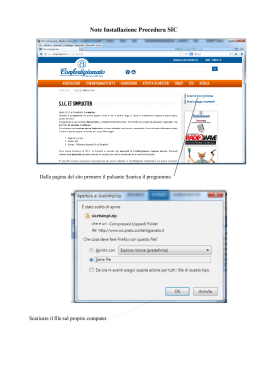
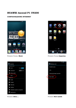
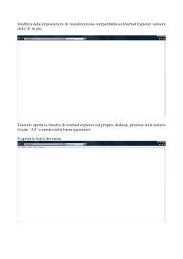
Scaricare