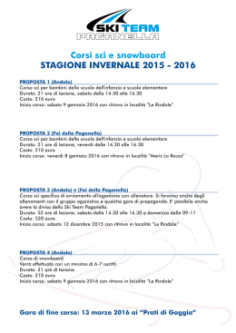
1
CASTELLI DI STENICO E TOBLINO - RIVA DEL GARDA
(andata e ritorno km 127)
km 0 - Andalo, Molveno, Fai della
Paganella, Cavedago e Spormaggiore. Da Molveno (864 m) si prosegue lungo la S.S. 421 per S. Lorenzo in Banale (758 m) e Dorsino
(635 m), dove si gira a destra per
km 18 – Stenico (667 m), centro del
Banale noto per il suo castello medioevale. All’interno del castello, visitabile tutto: il Salone romanico del
giudizio, il Salone Clesiano e la Torre
della Fame con le prigioni.
(Info: +39 0465 771004).
Si prosegue a destra verso
km 21 - Ponte Arche - Terme di Comano (400 m), nota località termale (Info: +39 0465
702626; www.visitacomano.to) e il
km 33 – Passo del Ballino (763 m) con i resti palafitticoli di Fiavè, proseguendo per il
km 37 – Lago di Tenno (570 m) e l’omonimo castello. Attraverso uliveti e vigneti (zona nota
per produzione del Vin Santo e della carne salada), si giunge al bivio per la cascata del Varone
che precipita per m 87 in un orrido suggestivo. Si arriva a
km 49 – Riva del Garda (73 m), cittadina posta sull’estremità settentrionale del lago di Garda.
Da visitare: la Rocca, costruzione del XII sec., il Bastione… Possibili escursioni in battello.
(Info: +39 0464 554444, www.gardatrentino.it)
km 53 – Torbole (85 m) patria della vela e del windsurf. Deviazione sulla S.S. 240 per
km 55 – Nago (222 m) sulla statale, a sinistra le «Marmitte dei Giganti»
km 62 – Arco (91 m) stazione climatica e di cura dominata dai ruderi dell’omonimo castello.
Ci si immette sulla S.S. 45 bis e, attraverso la zona delle «marocche», si arriva a
km 78 – Sarche (250 m) dove si prosegue a destra in direzione Trento per 2 km trovando il
km 80 – Lago di Toblino (250 m) con omonimo castello situato su stretta penisola, circondata su tre lati dall’acqua: suggestivo maniero, parzialmente trasformato in ristorante (Info: tel.
+39 0461 864036). Si ritorna indietro a
km 82 – Sarche (250 m) dove si imbocca sulla destra la S.S. 237 per Ponte Arche, S. Lorenzo in Banale arrivando a
km 127 – Molveno, Andalo, Fai della Paganella, Cavedago e Spormaggiore.
SCHLÖSSER VON STENICO UND TOBLINO - RIVA DEL GARDA Hin- u. Rückfahrt km 127
km 0 - Andalo, Molveno, Fai della Paganella, Cavedago und Spormaggiore. Von der Staatsstraße
421, die am Ostufer des Molvenosees entlang führt, durch S. Lorenzo in Banale (758 m), nach Dorsino (635 m) zweigt rechts eine Straße nach
km 18 - Stenico (667 m). Dieser Ort des Banale ist dank seiner mittelalterlichen Burg berühmt, einer
der ältesten in der Region. Sehenswert im Schloss sind der leichte aber berüchtigte Turm
(er wurde als Kerker benutzt), den man als »Torre della Fame« (Hungerturm) bezeichnet, der romanische Saal »Sala del Giudizio« und der Clesio-Saal. Ganzjährig zur Besichtigung frei. Man folgt
rechts der Straße nach
km 21 - Ponte Arche - Thermen von Comano (400 m), berühmtes Thermalzentrum, das ganz besonders auf Hautkuren spezialisiert ist. Hier zweigt die Straße durch Fiavé (Reste einer Pfahlbautensiedlung) steigend zum
km 33 - Ballino-Pass (763 m) und weiter nach dem
km 37 - Tennosee (570 m) und dem gleichnamigen Schloss. Auf der Panoramastraße, die zum
Gardasee hinabführt, zwischen Olivenhainen und Weingelände (dieses Gebiet ist für den Wein »Vino
Santo« und das Pökelfleisch »Carne salada« bekannt) liegt die Ortschaft Varone, mit den berühmten
87 Meter hohen Wasserfällen, und dann erreicht man
km 49 - Riva del Garda (73 m), altes Städtchen am Nordufer des Gardasees. Sehenswert sind die
massive Burg »La Rocca« aus dem 12. Jahrhundert und die »Bastione«, eine venezianische Festung. Möglichkeit zu Bootsfahrten. Die Straße verlässt Riva und erreicht
km 53 - Torbole (85 m) Heimat des Windsurfs und des Segelns. Abzweigung auf der Staatsstraße
240 nach
km 55 - Nago (222 m) links die »Marmitte dei Giganti« gennanten Gletschermühlen und nach
km 62 - Arco (91 m). Die Ortschaft, am Fuß der Ruine der gleichnamigen Burg (sie steht Besuchern
offen; beachtenswert ist der Wachturm), ist dank seines milden Klimas als Luftkurort bekannt. Die
Staatsstraße 45 bis führt nun durch das Gebiet der »Marocche«, riesiger Felsblöcke aus Kalkstein, nach
km 78 - Sarche (250 m). Von hier rechts in Richtung Trento; nach 2 km erreicht man
km 80 - den Toblinosee (250 m) mit dem gleichnamigen Schloss, das sich auf einer Halbinsel erhebt:
inmitten einer lieblich-romantischen Landschaft ist das Schloss zum Teil zu einem Restaurant verwandelt worden. Zurück längs des Seeufers nach
km 82 - Sarche (250 m). Man verlässt den Ort und folgt dann rechts der Staatsstraße 237, die durch
Ponte Arche und S. Lorenzo ansteigt und man erreicht
km 127 – Molveno (864 m), Andalo, Fai della Paganella, Cavedago und Spormaggiore.
Ton
CASTLES STENICO and TOBLINO - RIVA DEL GARDA (there and back: 127 km)
La posizione ottimale dell'altopiano Brenta-Paganella, nel cuore del Trentino, offre
al nostro ospite la possibilità di raggiungere in breve tempo: a sud il celebre lago di
Garda con la spettacolarità dei suoi parchi di divertimento, il romantico lago di
Toblino con il suo castello, la città di Rovereto con le sue tradizioni storiche, Castel
Beseno, Trento - capoluogo della Regione - con l'imponente castello del Buonconsiglio e il Duomo, sede del Concilio Tridentino; ad ovest il Parco Naturale AdamelloBrenta con Madonna di Campiglio e le cascate del Nardis, il massiccio dell'OrtlesCevedale e, a nord, il Parco Nazionale dello Stelvio, la Val di Non famosa per le
mele, San Romedio, Castel Thun ed il decantato lago di Tovel.
Da non dimenticare, a est, lo splendido scenario delle Dolomiti con Canazei, le
Piramidi di terra a Segonzano in Val di Cembra; e, ancora a nord, Bolzano, Merano
con gli stupendi giardini e le passeggiate, Innsbruck...
*
*
The high Brenta-Paganella plateau located in the very heart of Trentino, offers our guests the possibility of reaching many interesting touristic resorts
in a short time.
Southwards: the famous lake Garda with its spectacular entertainment
parks, the romantic lake Toblino with its castle; the town of Rovereto with its
historical attractions; Castle Beseno; Trento - the capital city of the region
- with its imposing Castle Buonconsiglio and the Cathedral (Duomo), famous for the Council of Trento.
Westwards: the Adamello-Brenta Nature Park with Madonna di Campiglio
and Nardis waterfalls; Ortles-Cevedale massif. To the north: the National
Park of Stelvio, the Non Valley, well-known for its apples, sanctuary of St.
Romedio, Castle Thun and the extolled lake Tovel.
Don't forget, to the east, the enchanting Dolomites with Canazei, the ground
Pyramids of Segonzano in Cembra Valley. And, more, to the north, Bolzano,
Merano with its marvellous gardens and promenades, Innsbruck...
Copyright by
Printed in Italy by
bolzano 0456 - Foto Banal, Besano, Deflorian, Faganello, Ludwig, Mairhofer, Spagnoli, Zotta
bolzano
km 0 – Departing from Molveno (864 m): drive along the S.S. 421 road towards S. Lorenzo
in Banale (758 m) and Dorsino (635 m) where you turn right to
km 18 – Stenico (667 m), headquarters of the Banale area and well-known for its medieval
castle. Worth visiting in the manor are the Romanesque room or the judgement, the Clesio room
and "the starvation tower“, which was a prison. Open to the public. Drive on to
km 21 – Ponte Arche - Terme di Comano (400 m), a famous spa resort and
km 33 – Ballino Pass (763 m) with the pile-dwelling remains of Fiavè. Continue towards
km 37 – Lake Tenno (570 m) and its castle. Across the olive-trees and vineyards (a typical
meat dish is carne salada, and this area is famous for the production of a sweet wine liqueur
called „Vin Santo“), you reach the fork to the Varone waterfall, a fascinating ravine with an 87
meter waterfall. We arrive in
km 49 – Riva del Garda (73 m), a small town situated on the northern border of lake Garda. Things
to see: the Fort, built in the 12th century, the Bastion... Boat excursions are available.
km 53 – Torbole (85 m) a sailing and windsurfing training area due to the wind, which makes
these two sports possible all year. Turn on to the S.S. 240 road towards
km 55 – Nago (222 m). Along the road, on your left, you can see the glacial phenomena (the
so-called „Giants’ Cauldrons“) and
km 62 – Arco (91 m), a holiday resort due to its marvellously mild climate and spas. At the
top of the cliff are the remains of Castle Arco.
Take the road (S.S. 45 bis) and, through the „Marocche“ landslide (a disorderly heap of loose
rocky material), reach
km 78 – Sarche (250 m) where following, on your right, the road leading to Trento at 2 kilometers, is
km 80 – Lake Toblino (250 m) with its Castle which is sited on a small peninsula, surrounded by water on three sides. The charming manor-house has been partly converted into a restaurant. Back to
km 82 – Sarche (250 m) where you take, on your right, the main road (S.S. 237) towards
Ponte Arche, S. Lorenzo in Banale getting to
km 127 – Molveno, Andalo, Fai della Paganella,Cavedago and Spormaggiore.
2
ROVERETO - CASTEL BESENO (andata e ritorno km 109)
km 0 – Andalo, Molveno, Fai della
Paganella, Cavedago e Spormaggiore. Da Fai della Paganella (958
m) fino al bivio per Mezzolombardo
per arrivare a
km 15 – S. Michele all’Adige (m
229), dove ci si immette sull’autostrada A22 fino al casello di Rovereto Nord. Si esce direzione centro
km 54 – Rovereto (m 204 – 30.000
abitanti ca.), seconda città del Trentino. Da visitare: il Castello dei Castelbarco, sede del Museo Storico
Italiano della Guerra (Info: tel. +39 0464 438100, www.visitrovereto.it) e la Campana dei Caduti, fusa nel 1924 con il metallo dei cannoni delle 19 nazioni che presero parte alla 1a guerra mondiale, spostata nel 1964 sul colle di Miravalle da dove fa sentire i suoi rintocchi a ricordo dei caduti e quale invocazione di pace per tutti i popoli, ed il Mart (Museo d'Arte
Moderna e Contemporanea). Prendere la S.S. 12 verso Nord; sulla destra, sopra un colle,
all’entrata della Valle del rio Cavallo si erge
km 64 – Castel Beseno (m 450), il più vasto complesso fortificato feudale non urbano di
epoca alto-medievale. Visitabile (Info: tel. +39 0464 834600).
Di ritorno su S.S. 12 fino a S. Michele all’Adige, dove si imbocca la S.S. 43 fino a Mezzolombardo e poco dopo il bivio (km 112) per
km 109 - Fai della Paganella, Andalo, Molveno, Cavedago e Spormaggiore.
ROVERETO – SCHLOSS BESENO Hin- u. Rückfahrt km 109
km 0 - Von Fai della Paganella (958 m) führt die Landesstraße 64 nach Mezzolombardo und
km 15 - San Michele all’Adige (229 m). Einfahrt in die Brenner-Autobahn A22 gegen Süden nach
Rovereto Nord. Hier folgt man der Straße in Richtung Stadtzentrum bis
km 54 - Rovereto (204 m – 30.000 Einwohner) der zweiten Stadt des Trentino. Sehenswert sind in
Rovereto das Historische Kriegsmuseum im Schloss Castelbarco, eines der bedeutendsten seiner Art
in Italien, und die »Gefallenenglocke«, die im Jahre 1924 aus der Bronze der Kanonen gegossen wurde,
die alle 19 am ersten Weltkrieg beteiligten Staaten geliefert hatten. Jeden Abend lässt sie vom nahen
Miravalle-Hügel aus ihr dumpfes Läuten zur Erinnerung an die Gefallenen aller Kriege erklingen. Sehenswert ist auch das Mart (Museum für moderne und zeitgenössische Kunst). Auf der Brenner-Staatsstraße 12 gegen Norden; rechts erhebt sich auf einem Hügel, am Eingang des Tals des Rio Cavallo,
km 64 - die Burg Beseno (450 m). Es handelt sich um den größten außerstädtischen Festungskomplex aus feudaler Zeit im ganzen Trentino .
Von hier gelangt man wieder über die Staatsstraße 12 in nordlicher Richtung nach S.Michele
all’Adige; dann Abzweigung nach Mezzolombardo und kurz nach der Ortschaft zweigt man links nach
km 109 - Fai della Paganella, Andalo, Molveno, Cavedago und Spormaggiore.
ROVERETO - CASTLE BESENO (there and back: 109 km)
km 0 – Departing from Fai della Paganella (958 m): drive to Mezzolombardo going on up to
km 15 – S. Michele all’Adige (229 m), take the A-22 motorway southwards as far as Rovereto-North exit. Drive towards
km 54 – Rovereto center (204 m – 30.000 inhabitants approx.): the second biggest town in
Trentino. Worth visiting are: Castle Castelbarco, seat of the Historical War Museum and The Bell
of the Fallen Soldiers of all the wars of the world, an enormous bell fused in 1924 with the bronze
from the cannons of the 19 nations taking place at the First World War. In 1964 it was put on
the Miravalle hill, from which its forlorn peals ring out in memory of the fallen soldiers of all
the wars of the world as a real sense of Peace. Worth visiting is also the Mart (Modern and
Contemporary Art Museum).Take the S.S. 12 road northwards to Trento. After a few kms, on
your right over the hill, at the entrance of the rio Cavallo Valley, you find
km 64 – Castle Beseno (450 m), the most extensive feudal fortified complex of non-urban
origin built in the Medieval period. Open to visitors.
Back on the S.S. 12 road as far as S. Michele all’Adige, where you take the S.S. 43 road to
Mezzolombardo. After a few kilometers, turn to the left (112 km) to
km 109 – Fai della Paganella, Andalo, Molveno, Cavedago and Spormaggiore.
3
PIRAMIDI DI SEGONZANO - CASTELLO DI PERGINE
(andata e ritorno km 115)
km 0 – Andalo, Molveno, Fai della
Paganella, Cavedago e Spormaggiore. Da Fai della Paganella fino al
bivio per Mezzolombardo per arrivare a
km 15 – S. Michele all’Adige (m
229), dove ci si immette sulla S.S. 12
in direzione Trento, fino all’abitato di
km 21 – Lavis (m 205) dove troviamo il bivio per la Val di Cembra, nota
per le cave di porfido e i vigneti.
Oltrepassato il paese di Cembra, si
prosegue per Fàver (m 673) dove si
devia a destra per
km 40 – Segonzano (m 660) con le omonime Piramidi, suggestive costruzioni di terra alte
alcune decine di metri nate dall’erosione dell’acqua, con una pietra come cappello. Si prosegue e prima di
km 49 – Sover (m 831) si incontra il bivio per Bedollo, Altopiano di Pinè. Si arriva quindi a
km 66 – Baselga di Pinè (m 967) dopo aver oltrepassato i laghi di Piazze e Serraia. Da visitare: Chiesa gotica dell’Assunta (Info: tel. +39 0461 557028, www.visitpinecembra.it).
Si prende ora a sinistra per Miola e Faida (m 972), scendendo fino a
km 77 – Pergine Valsugana (m 482) con l’omonimo maniero, oggi trasformato in ristorante
e albergo. Parzialmente visitabile (Info: tel. +39 0461 531158). Ritorno verso
km 88 – Trento (m 198) sulla S.S. 47 che porta direttamente sulla S.S. 12 fino a Lavis-San
Michele a/Adige dove troviamo il bivio per Mezzolombardo e qui (km 112) quello per
km 115 – Fai della Paganella, Andalo, Molveno, Cavedago e Spormaggiore.
ERDPYRAMIDEN VON SEGONZANO – SCHLOSS PERGINE
Hin- u. Rückfahrt km 115
km 0 - Von Fai della Paganella führt die Landesstraße 64 nach Mezzolombardo und
km 15 - San Michele all’Adige (229 m). Nach der Etschbrücke zweigt man rechts auf die BrennerStaatsstraße 12 bis
km 21 - Lavis (205 m). Links Abzweigung in das Cembratal (blühend sind hier die Porphyrindustrie
und der Weinbau). Nach dem Dorf Cembra berührt man Fàver und zweigt man rechts nach
km 40 - Segonzano (660 m) mit den berühmten Erdpyramiden, die durch Verwitterung und Auswaschung entstanden und bis zu 20 Meter hoch sind.
Kurz nach Segonzano, vor Sover, zweigt man rechts in Richtung der Hochebene von Piné, durch
Bedollo und die Seen von Piazze und Serraia, nach
km 66 - Baselga Di Piné (967 m) wo die gotische Himmelfahrtskirche sehenswert ist.
Nach Baselga fällt die Straße links leicht ab und führt durch Miola und Faida (972 m) nach
km 77 - Pergine (482 m) mit der gleichnamigen Burg, die heute in Privatbesitz ist und ein HotelRestaurant beherbergt. Zum Teil zur Besichtigung freigegeben.
Rückfahrt auf der Staatsstraße 47 nach
km 88 - Trient (198 m). Vor der Stadt Abzweigung auf die Staatsstraße 12 nach Lavis, S.Michele
all’Adige und Mezzolombardo und kurz nach der Ortschaft zweigt man links nach
km 115 - Fai della Paganella, Andalo, Molveno, Cavedago und Spormaggiore.
SEGONZANO PYRAMIDS - CASTLE PERGINE (there and back: 115 km)
km 0 – Departing from Fai della Paganella: drive to Mezzolombardo, continue straight ahead as far as
km 15 – S. Michele all’Adige (229 m) where you take the S.S. 12 road towards Trento. Drive
until you arrive at
km 21 – Lavis (205 m), the fork to the Cembra Valley. This area is known for its porphyry quarries
and veneyards. Going on beyond the village of Cembra, reach Fàver and turn to the right towards
km 40 – Segonzano (660 m) with its Pyramids, a fascinating series of concretions (10 m appx.
high) made of morainic material topped by a huge stone. Before reaching
km 49 – Sover (831 m), detour to Bedollo - Pinè High Plateau. Go on until you get to
km 66 – Baselga di Pinè (967 m) after the lakes Piazze and Serraia. Worth visiting is: the
gothic Church of Assunta.
Take the road left towards Miola and Faida (972 m), driving down to
km 77 – Pergine Valsugana (482 m) with its manor, which has been transformed into an
hotel and restaurant. Partially open to visitors. Go back towards
km 88 – Trento (198 m) on the S.S. 47 road which directly leads onto the S.S. 12 road to
Lavis and San Michele a/Adige where you find the crossroads to Mezzolombardo and over
there (112 km) another one to
km 115 - Fai della Paganella, Andalo, Molveno, Cavedago and Spormaggiore.
4
MARMOLADA (andata e ritorno km 233)
km 0 – Andalo, Molveno, Fai della
Paganella, Cavedago e Spormaggiore. Da Fai della Paganella fino al bivio
per Mezzolombardo per arrivare a
km 15 – S. Michele all’Adige (229
m) dove ci si immette sulla A 22 in
direzione Bolzano fino all’uscita
km 34 – Egna-Ora (218 m); si imbocca quindi la SS 48 delle Dolomiti,
sottopassando Cavalese (1000 m)
(km 64), capoluogo della Val di
Fiemme, sede della Magnifica Comunità di Fiemme (Info: tel. +39 0462
241111, www.visitfiemme.it),
per giungere a
km 71 - Predazzo (1018 m), sede della Scuola Alpina delle Fiamme Gialle. Si prosegue per
km 80 – Moena (1184 m), primo centro della Val di Fassa e sede della Scuola Alpina delle
Fiamme Oro, costeggiando il Gruppo del Catinaccio e le Torri del Vajolet fino ai piedi del
Gruppo del Sella e della Marmolada arrivando a
km 103 – Canazei (1.465 m), rinomato centro turistico della Valle di Fassa (Info: tel. +39 0462 609500,
www.fassa.com). Si devia sulla destra per Alba e Penia sulla SS 641 del Passo Fedaia che porta al
km 115 – panorama grandioso sul più alto gruppo delle Dolomiti, la Marmolada (3.343 m) (Info:
tel. +39 0437 722277, www.marmolada.com), un ghiacciaio di 3,5 kmq. La strada prosegue
fino ai rifugi Castiglioni e Fedaia (2.054 m); costeggiando il lago di Fedaia, si arriva all’omonimo
passo. Poco dopo la diga, la strada sale alla stazione della seggiovia per il Pian dei Fiacconi
(2.650 m) ai margini estremi del ghiacciaio. Ritorno sullo stesso percorso sino a
km 233 - Fai della Paganella, Andalo, Molveno, Cavedago e Spormaggiore.
MARMOLADA Hin- und Rückfahrt: 233 km
km 0 - Von Fai della Paganella führt die Landesstraße 64 nach Mezzolombardo und
km 15 - San MIchele all’Adige (229 m). Einfahrt in die Brenner-Autobahn A22 in Richtung Bozen bis
zur Ausfahrt
km 34 - Neumarkt - Auer (218 m). Man folgt der Dolomiten-Staatsstraße Nr. 48, die in vielen Kehren
ansteigt und unterhalb von Cavalese (1.000 m) (64 km) durchzieht (Hauptort des Fleimstals, Sitz der
Fleimser Talgemeinschaft) bis
km 71 - Predazzo (1.018 m), Sitz der Alpinschule der »Fiamme Gialle«. Nach Predazzo steigt die
Straße leicht an und erreicht
km 80 - Moena (1.184 m), die erste Ortschaft des Fassatals und Sitz der Alpinschule der »Fiamme
d'Oro«. In nordlicher Richtung verläuft die Straße nun weiter, mündet ins Fassatal ein und führt dem
Rosengarten und den Vajolettürmen entlang bis zum Fuß der Sellagruppe und Marmolada nach
km 103 - Canazei (1.465 m) einem bedeutenden Wintersportort des Fassatals. Rechts zweigt die
Staatsstraße 641 ab, die über Alba und Penia zu einem großartigen Panorama
km 115 - auf die höchste Gruppe der Dolomiten führt: die »Marmolada«, die Dolomitenkönigin (3.343
m) mit einem 3,5 km2 großen Gletscher. Die Straße führt nun weiter zu den Castiglioni- und FedaiaHütten (2.054 m) und zieht sich dem Fedaiasee entlang, bis zum Fedaia-Pass (2.057 m). Nach dem
Staudamm steigt die Straße zur Talstation des Pian-dei-Fiacconi-Sesselliftes an (2.650 m), am Fuße
des Gletschers.
Rückfahrt auf derselben Straße bis
km 233 - Fai della Paganella, Andalo, Molveno, Cavedago und Spormaggiore.
MARMOLADA (there and back: 233 km)
km 0 – Depart from Fai della Paganella: drive on, up to the Mezzolombardo fork going on
straight ahead to
km 15 – S. Michele all’Adige (229 m) where you drive onto the A22-Brenner motorway northwards to
km 34 – Egna-Ora (218 m) exit. Take the State Road 48 to the Dolomites, the underpass of
Cavalese (1000 m) (km 64), chief town of the Fiemme Valley and seat of the “Magnificent
Community of Fiemme“ building - reaching
km 71 - Predazzo (1018 m), seat of the Customs Officer Alpine School (known as the “Fiamme
gialle“ - yellow flames). Drive on towards
km 80 – Moena (1184 m), the gateway to the Fassa Valley, home of the Policemen Alpine
School (known as the ‘Fiamme oro’), skirting the Catinaccio Group, the Vajolet Towers as far
as you arrive at the foot of the Sella and Marmolada mountains.
km 103 – Canazei (1.465 m), the most renowned touristically town of the Fassa Valley.
Turn to the right on the SS 641 road towards Alba, Penia and
km 115 – a breathtaking view of the the highest peak of the Dolomites, the Marmolada glacier
(3.343 m), 3,5 kilometers wide.
The road leads to the Castiglioni and Fedaia alpine huts (2.054 m); driving along the shores of
the Fedaia lake, you reach the pass with the same name.
After the dam, the road leads where chairlift departs for the Pian dei Fiacconi (2.650 m). Back
on the same way.
km 233 – Fai della Paganella, Andalo , Molveno, Cavedago and Spormaggiore.
5
LAGO DI CAREZZA - PASSO SELLA - PASSO GARDENA
GIRO DEL BRENTA (CAMPIGLIO E CASCATE DEL NARDIS)
(andata e ritorno km 137)
km 0 – Andalo, Molveno, Fai della Paganella, Cavedago e Spormaggiore.
Da Molveno si prosegue lungo la S.S.
421 per S. Lorenzo in Banale e
km 25 – Ponte Arche-Terme di Comano
(400 m), nota località termale, dove si
prosegue sulla S.S. 237 in direzione
km 37 – Tione (565 m), capoluogo
delle Giudicarie, posto tra la Valle
Rendena e la Valle del Chiese.
All’entrata del paese si trova il bivio
per immettersi sulla S.S. 239 entrando in Val Rendena (Info: www.valrendena.net)
km 53 – Pinzolo (770 m) base di partenza per escursioni nel gruppo del Brenta e sui ghiacciai
dell’Adamello e della Presanella. Da vedere: la chiesa di S. Vigilio con l’affresco della Danza
Macabra. Superato l’abitato di Carisolo (808 m), si svolta a sinistra e si imbocca la strada della
Valle di Genova fino alle spettacolari
km 59 – Cascate del Nardis (920 m), nel cuore del Parco Naturale Adamello-Brenta, alte più di
cento metri. Si ritorna a Carisolo per imboccare, a sinistra, la strada per
km 77 – Madonna di Campiglio (1.522 m) noto centro turistico dominato dalle cime del massiccio del Brenta. Possibilità di salire in quota con gli impianti (Info: +39 0465 447501, www.campigliodolomiti.it).
Si prosegue verso Passo Campo Carlo Magno (1.681 m), per poi scendere a Dimaro (766 m)
dove si gira a destra verso
km 99 – Malè (738 m) - capoluogo della Val di Sole -, Cles (658 m) – capoluogo della Val di
Non -e giunti alla
km 132 – Rocchetta (274 m) si rientra a
km 137 – Andalo, Fai della Paganella, Molveno, Cavedago e Spormaggiore.
BRENTADOLOMITEN-RUNDFAHRT (Madonna di Campiglio, Nardis-Wasserfälle) km 137
km 0 - Andalo, Molveno, Fai della Paganella
km 25 - Ponte Arche – Die Thermen von Comano
km 37 - Tione
km 53 - Pinzolo
km 59 - Nardis-Wasserfällen
(andata e ritorno km 238)
km 0 – Andalo, Molveno, Fai della
Paganella, Cavedago e Spormaggiore. Da Fai della Paganella fino al bivio per Mezzolombardo per arrivare a
km 15 – S. Michele all’Adige (229
m) dove ci si immette sulla A 22 in
direzione Bolzano fino all’uscita
km 34 – Bolzano Nord; si imbocca
quindi la SS 12, direzione Brennero.
Dopo circa 1,5 km, bivio sulla sinistra
per la Val d’Ega che si imbocca percorrendo in una stretta gola la SS
241- Grande Strada delle Dolomiti.
(Info: Associazione turistica
Val d'Ega - Nova Ponente - Ober-
eggen tel. +39 0471 616567).
Dopo 10 km circa, si iniziano a vedere le Dolomiti del Latemar (Info: Consorzio Turistico Rosengarten – Latemar tel. +39 0471 610310) e, attraverso Ponte Nova (870 m) e Nova Levante (1.132 m), si giunge al
km 84 – Lago di Carezza (1.609 m) splendido laghetto circondato da un bosco di abeti rossi
e bianchi (Info: Associazione turistica Nova Levante-Carezza, Tel. +39 0471 613126).
Dopo 1 km, si raggiunge Passo Costalunga (1.745 m) con lo spettacolare Catinaccio, detto
anche Rosengarten (ossia giardino delle rose). Proseguendo, si scende fino a Vigo di Fassa
(1.382 m), per prendere, dopo circa 1 km, a sinistra la S.S. 48 per Canazei (1.465 m). Qui si
imbocca la strada che con ripidi tornanti ci porta ai piedi del Piz de Ciavazes, per valicare il
km 121 – Passo Sella (2.244 m) dove si gode un incomparabile panorama sulle Cime del
Sassolungo, sul Gruppo del Sella, la Marmolada e la Valle di Fassa. Proseguendo si arriva in
Val Gardena e, attraverso gli abitati di Selva Gardena e S. Cristina, si giunge a
km 140 – Ortisei (1.234 m) centro turistico rinomato per la scuola di scultura e artigianato del
legno. Da visitare: la Chiesa di Sant’Udalrico e il Museo della Gardena (Info: Associazione turistica Ortisei,Tel. +39 0471 777600 , www.valgardena.it).
Lasciata Ortisei, si prosegue fino a Chiusa per imboccare la S.S. 12 – direzione Bolzano. A Bolzano-Nord si entra in autostrada – direzione Trento, uscendo al casello di S. Michele all’Adige per
rientrare a
km 238 – Fai della Paganella, Andalo, Molveno, Cavedago e Spormaggiore.
KARERSEE – SELLAJOCH – GRÖDNER JOCH Hin- u. Rückfahrt
6
km 238
km 0 - Von Fai della Paganella führt die Landesstraße 64 nach Mezzolombardo und
km 15 - San Michele all’Adige (229 m). Einfahrt in die Brenner-Autobahn A22 in Richtung Norden bis zur
Ausfahrt
km 34 - Bozen-Nord; man folgt der Staatsstraße 12, in Richtung Brenner. Nach 1,5 km, Abzweigung ins
Eggental auf der Dolomiten-Staatsstraße 241. Die Straße führt weiter und nach 10 km bietet sich ein
herrlicher Ausblick auf die Latemar-Gruppe.
Über Birchabruck und Welschnofen, erreicht man den
km 84 - Karersee (1.609 m), einen wunderbaren kleinen See, von Rot- und Weißtannen umgegeben.
Kurz danach gelangt man zum Karerpass (1.745 m) mit dem großartigen Rosengarten. Die Straße
fällt bis Vigo di Fassa (1.382 m) leicht ab und nach 1 km zweigt man links auf die Staatsstraße nach
Canazei (1.465 m) ab. Hier steigt die Straße mit steilen Kehren zum Pian Schiaveneis an, wo sie sich
gabelt: links führt sie am Fuß des Piz de Ciavazes entlang auf das
km 121 - Sellajoch (2.244 m), von dem man einen herrlichen Ausblick auf den Langkofel, die Sella, die
Marmolada und das Fassatal hat.
Vom Pass aus fällt die Straße ins Grödner Tal ab und über Wolkenstein und St. Christina erreicht man
km 140 - St. Ulrich (1.234 m), den berühmten Ferienort der Dolomiten, Wiege der Holzschnitzerkunst.
Sehenswert die St.Ulrich-Pfarrkirche und das Grödner Museum.
Man verläßt St.Ulrich und gelangt nach Klausen, wo man die Staatsstraße 12 oder die Brenner-Autobahn erreicht. Man fährt nach Süden bis S.Michele all’Adige, dann Abzweigung nach Mezzolombardo
und kurz nach der Ortschaft zweigt man links nach
km 238 - Fai della Paganella, Andalo, Molveno, Cavedago und Spormaggiore.
LAKE CAREZZA- SELLA PASS- GARDENA PASS (there and back: km 238)
km 0 – Depart from Fai della Paganella: drive to Mezzolombardo fork going on straight ahead to
km 15 – S. Michele all’Adige (229 m) from where you drive onto the A22-Brenner motorway
northwards to
km 34 – Bolzano North exit. Take north going S.S. 12-Brenner road. After approx. 1,5 km drive,
turn to the left ascending through the wide gorge of the Ega Valley (the S.S. 241 road - Main
Road of the Dolomites). Just a 10 kilometres’ drive to see the Latemar mountains, and, after
passing Ponte Nova (870 m) and Nova Levante (1.182 m), you reach
km 84 – Lake Carezza (1.609 m) a splendid small lake encircled by a red and white fir wood.
One kilometer more, the Costalunga Pass (1.745 m) enjoys a very beautiful panoramic perspective of the Catinaccio group of mountains, the so called Rosengarten (the garden of roses).
Go down to Vigo di Fassa (1.382 m). After 1 km approx., take the S.S. 48 road on your left towards Canazei (1.465 m) where you climb up by steep bends of the road at the foot of the Piz de
Ciavazes and cross over the
km 121 – Sella Pass (2.244 m): overlooked by an incomparable panorama: the Sassolungo
peaks, Sella group of mountains, Marmolada glacier and Fassa Valley
Drive on towards the villages of Selva Gardena, S. Cristina and
km 140 – Ortisei (1.234 m) a touristic resort well known for its wood carving school. Worth
visiting are: St. Ulrich Parish Church and the Val Gardena Local Heritage Museum.
Leave Ortisei and drive to Chiusa, taking the S.S. 12 road as far as Bolzano-North entrance of
the A-22 motorway – southwards Trento. Leave the motorway at the exit marked S. Michele
all’Adige. Go back to
km 238 – Fai della Paganella, Andalo, Molveno, Cavedago and Spormaggiore.
km 53 – Malè (738 m), main town of the Sun Valley (Val di Sole) Worth visiting is: the
Ethnographic Museum of the Val di Sole cultural heritage (Info: tel +39 0463 901280; www.
valdisole.net),
km 69 – Cusiano (925 m) where you take - on your right - the Peio Valley road to
km 78 – Peio Terme (1.389 m), a spa resort with mineral waters at the foot of the Cevedale
mountains in the Stelvio National Park. A 3 kilometers drive, you reach Peio, at the foot of the Vioz
mountain.
km 88 – Stelvio National Park: the most extensive protected area in Italy, it embraces the
entire mountain massifs of Ortles-Cevedale in Trentino, Alto-Adige and Lombardy with more
than 100 glaciers, and several peaks over 3.000 meters high. Excursions with Alpine guides is
available. Back on the same road up to Cles towards Tuenno - Denno - the Rocchetta km 174 – Andalo, Fai della Paganella, Molveno, Cavedago and Spormaggiore.
8
TRENTO - SAN MICHELE ALL’ADIGE (andata e ritorno km 74)
km 0 – Andalo, Molveno, Fai della
Paganella, Cavedago e Spormaggiore. Da Fai della Paganella fino a
km 13 – Mezzolombardo (229 m),
centro enologico della Piana Rotaliana
noto per il vino Teroldego. Si prosegue
per S. Michele all’Adige, superato il
ponte sull’Adige si svolta a destra immettendosi sulla S.S. 12. Si prosegue
verso Lavis fino ad arrivare a
km 36 – Trento (198 m – ca. 100.000
ab.) capoluogo della regione Trentino-Alto Adige, fu sede dei principivescovi per otto secoli ed ospitò,
nel 1545, il Concilio di Trento (Info: tel. +39 0461 216000, www.apt.trento.it). Da visitare in città:
il Castello del Buonconsiglio (Info: tel. +39 0461 233770, www.buonconsiglio.it), i palazzi del centro storico, il Duomo, la Fontana del Nettuno al centro della piazza omonima e il Museo Diocesano Tridentino (Info: tel. +39 0461 234419), la Chiesa di Santa Maria Maggiore, il Palazzo delle
Albere, sede del Museo d’Arte Moderna e Contemporanea di Trento e Rovereto (Info: tel. + 39 0461
234860, www.mart.tn.it), il Dos Trento con il mausoleo di Cesare Battisti (Info: tel. +39 0461
827248), il Museo di Scienze Naturali (Info: tel. +39 0461 270311).
Tutti i giovedì mattina, inoltre, si svolge nel centro storico il mercato.
Il ritorno segue la stessa strada con sosta a
km 52 - San Michele all’Adige (229 m) al Museo Provinciale degli Usi e Costumi della Gente
Trentina, posto nei locali dell’antico convento degli Agostiniani di San Michele. Si distingue per
l’attenzione che dedica allo studio e all’esposizione delle forme e degli utensili del lavoro contadino (Info: +39 0461 650314, www.museosanmichele.it). Poco distante c’è l’Istituto Agrario,
centro di ricerca e sperimentazione scientifica, di istruzione e formazione nonché di servizio
alle imprese (Info: tel. +39 0461 615111, www.ismaa.it).
Tornati sulla strada, si imbocca a sinistra la strada verso Mezzolombardo e quindi il bivio per
km 74 - Fai della Paganella, Andalo, Molveno, Cavedago e Spormaggiore.
TRIENT – SAN MICHELE ALL’ADIGE
km 77 - Madonna di Campiglio
Campo-Carlo-Magno-Pass
km 99 - Malè
Dimaro
Hin- u. Rückfahrt km 74
km 0 Fai della Paganella
km 13 - Mezzolombardo
Cles
km 132 - Rocchetta
km 137 - Andalo, Fai della Paganella, Molveno, Cavedago und Spormaggiore
km 36 - Trient
BRENTA TOUR (Campiglio and Nardis waterfalls) (there and back: 137 km)
km 0 – Depart from Molveno: follow the S.S. 421 road to S. Lorenzo in Banale and
km 25 – Ponte Arche - Terme di Comano (400 m), a well-known spa resort. Continue on the
S.S. 237 road towards
km 37 – Tione (565 m), main town of the Giudicarie, lying between Rendena Valley and Chiese Valley. At the town entrance, take the fork to the Rendena Valley (S.S. 239 road).
km 53 – Pinzolo (770 m) starting-point for excursions in the Brenta group and on the Adamello-Presanella glaciers. Worth visiting are: St. Vigilio church with the fresco of the Dance macabre.
Leave Carisolo (808 m), turn to the left taking the Genova Valley road to the imposing
km 59 – Nardis Waterfall (920 m), a waterfall of more than 100 meters located in the heart of the
Adamello-Brenta Nature Park. Back to Carisolo, turn to the left and go on along the SS 239 road
towards
km 77 – Madonna di Campiglio (1.522 m) a famous tourist resort which lies at the foot of the
Brenta Dolomites. Network of lifts available. Drive on towards Campo Carlo Magno Pass
(1.681 m), coming down to Dimaro (766 m) where you turn right. Back to
km 99 – Malè, the main town of the Sun Valley - Cles, the main town of the Non Valley km 132 – the Rocchetta (274 m)
km 137 – Andalo, Fai della Paganella, Molveno, Cavedago and Spormaggiore.
7
PARCO NAZIONALE DELLO STELVIO (andata e ritorno km 174)
km 0 – Andalo, Molveno, Fai della
Paganella, Cavedago e Spormaggiore. Da Spormaggiore fino alla località
Rocchetta. Si svolta a sinistra immettendosi sulla S.S. 43 fino a
km 38 – Cles (658 m) capoluogo della
Valle di Non, località famosa per le
mele. Da visitare: la chiesetta di S. Vigilio. Si prosegue verso
km 53 – Malè (738 m), il centro più
importante della Valle di Sole (Info: +39
0463 901280, www.valdisole.net), fino a
giungere a
km 69 – Cusiano (925 m) dove, svoltando a destra, ci si immette nella Valle di Peio che si
percorre fino a
km 78 – Peio Terme (1.389 m), località termale con fonte di acque minerali ai piedi del Cevedale nel Parco Nazionale dello Stelvio (Info: Terme di Pejo tel. +39 0463 753226). Dopo 3 km si
giunge a Peio paese, sulle pendici del monte Vioz e continuando per il
km 88 – Parco Nazionale dello Stelvio. Il Parco più vasto d’Italia, si sviluppa sull’intero gruppo montuoso dell’Ortles-Cevedale tra Trentino, Alto-Adige e Lombardia con più di 100 ghiacciai e varie cime
sopra i 3.000 metri. Possibili escursioni con guide alpine (Info: Comitato di gestione per la Provincia Autonoma di Trento - Malè tel. +39 0463 903046 www.stelviopark.it). Stesso tragitto per il ritorno fino a Cles, dove si può deviare per Tuenno-Denno e ritornare alla Rocchetta fino a
km 174 - Andalo, Fai della Paganella, Molveno, Cavedago e Spormaggiore.
STILFSER-JOCH-NATIONALPARK
Hin- u. Rückfahrt km 174
km 0 –
Spormaggiore
km 38 – Cles
km 53 – Malè
km 69 – Cusiano
km 78 – Peio Terme
km 88 – den Stilfser-Joch-Nationalpark
km 174 – Andalo, Fai della Paganella, Molveno, Cavedago und Spormaggiore
STELVIO NATIONAL PARK (there and back: 174 km)
km 0 - From Spormaggiore reach the Loc. Rocchetta (250 m). Turn left, following the S.S. 43
road up to
km 38 – Cles (658 m) the main town of the Non Valley, famous resort for apples. Worth visiting
is: St. Vigilio Church. Go on towards
km 52 - San Michele all’Adige
km 74 - Fai della Paganella, Andalo, Molveno, Cavedago und Spormaggiore.
TRENTO - SAN MICHELE ALL’ADIGE (there and back: 74 km)
km 0 – Drive from Fai della Paganella as far as
km 13 – Mezzolombardo (229 m), a small town in the Rotaliana Plain, famous for its tasty red
wine, called Teroldego.
Drive towards S. Michele a/Adige, cross the bridge over the river Adige and take the S.S. 12
road to the right towards Lavis and
km 36 – Trento (198 m – 100.000 inhabitants approx.) Administrative centre of the TrentinoAlto Adige Region, it was the seat of the Prince-Bishops for 800 years. The famous Ecumenical
Council of Trento took place here from 1545 to 1563. Worth visiting are: Buonconsiglio castle,
illustrious buildings of the historical centre, the Cathedral, Fountain of Neptun and the Diocesan Museum of Trento, S. Maria Maggiore Church, the Albere Manor, today seat of the Museum of Modern and Contemporary Art of Trento and Rovereto; the hill called Dos Trento, where
the mausoleum dedicated to C. Battisti is sited, the Museum of Natural Sciences.
On Thursday mornings the weekly market is held in the city centre, until 13 p.m.
Go back along the same way up to
km 52 - San Michele all’Adige (227 m) at the Museum of the Uses and Customs of the people of
Trentino, located in the former Augustinian monastery at San Michele. This museum distinguishes itself among others for the attention it pays to the study and the exhibition of the tools
and implements of peasant work. In the neighbourhood, there is the Institute for Agriculture,
research center and of scientific experiments, dedicated to education and training as well as
helping companies.
Back to Mezzolombardo and
km 74 - Fai della Paganella, Andalo, Molveno, Cavedago and Spormaggiore.
9
cappelle ed un ospizio. È dedicato all’eremita Romedio (Info: tel. +39 0463 536198, www.visitvaldinon.it). Si ritorna a Sanzeno, poi a Dermulo dove si imbocca la S.S. 43 passando per
Taio e Mollaro e si raggiunge
km 80 – Rocchetta (274 m). Bivio per
km 95 - Andalo, Fai della Paganella, Molveno, Cavedago e Spormaggiore.
TOVELSEE - WALLFAHRTSKIRCHE SAN ROMEDIO hin u.retour km 95 - SCHLOSS THUN
km 0 Andalo
km 15 - Rocchetta
km 23 Vigo di Ton/Schloss Thun
km 24 - Denno
km 34 - Tuenno
km 46 - Tovelsee
km 51 - Cles
km 59 - Sanzeno
km 62 - Wallfahrtskirche San Romedio
INNSBRUCK (AUSTRIA) (andata e ritorno km 358)
km 0 – Andalo, Molveno, Fai della
Paganella, Cavedago e Spormaggiore. Da Fai della Paganella fino al bivio
per Mezzolombardo per arrivare a
km 15 – S. Michele all’Adige (229 m)
dove si accede all’austostrada A22 –
direzione Bolzano sino al Passo del
Brennero. Da ammirare masi e castelli
nel tratto Prato Isarco - valico di frontiera. Dal
km 134 – Passo del Brennero (1373
m) si prosegue, fino alla prima uscita
in territorio austriaco denominata
Brennersee, immettendosi poi sulla
statale che porta a Innsbruck. Attraversati i paesini di Gries, Steinach e Matrei,
ci si imbatte prima in un punto panoramico con vista sul ponte più alto del nostro continente,
il cosiddetto Ponte Europa (198 m) per giungere poi a
km 174 – Innsbruck (500 m – ca. 120.000 ab.) capitale del Tirolo. Da visitare: l’Hofburg (palazzo imperiale), l’Hofkirche (Chiesa imperiale) con la Cappella d’argento (Silberne Kapelle), gli
Hofgarten (giardini imperiali), la zona pedonale del centro storico con il Goldenes Dachl (tettuccio d’oro). Possibilità di salita all’Alpen-Zoo con trenino a cremagliera (Info: Tirol Werbung,
Maria-Theresien-Str. 55 A-6010 Innsbruck, Tel. +43 512 59 850, www.innsbruck-tourismus.com).
Per il rientro, si consiglia l’entrata in autostrada al casello Innsbruck-Süd. Si transita sul Ponte Europa (pedaggio) uscendo al casello di San Michele all’Adige. Quindi rientro per Mezzolombardo.
km 358 - Fai della Paganella, Andalo, Molveno, Cavedago e Spormaggiore.
INNSBRUCK (Österreich) Hin- u. Rückfahrt
km 80 - Rocchetta
km 95 - Andalo, Fai della Paganella, Molven, Cavedago und Spormaggiore
LAKE TOVEL - SANCTUARY OF ST. ROMEDIO (there and back: 95 km) - CASTLE THUN
km 0 – From Andalo: drive onto the SS 43 road towards Cavedago and Spormaggiore to reach
km 15 – Rocchetta (274 m). Turn left following few meters the S.S.43, road up to S.P.73 to the
left of the tunnel, continue optionally towards km 23 – Vigo di Ton/Castle Thun (route 9 bis)
and back to Rocchetta area, and continue now towards
km 24 – Denno (429 m), Cunevo, Flavon and Terres famous areas for apples. Continue towards
km 34 – Tuenno (629 m): in the center of the town, crossroad to the Tovel Valley, following the
S.P. 14 road. Proceeding along this wild valley of the Adamello-Brenta park for 12 kms, you
finally reach
km 46 – Lake Tovel (1177 m) is famous because it used to turn red for a phenomenon (which
stopped in the sixties) due to the presence of single-cell algae Glenodinium Sanguineum. Encircled by a lovely wood, this lake has the Brenta Group peaks in the background. After leaving
Tovel valley, in Tuenno you drive towards
km 51 – Cles (658 m), the main town of Non Valley. Worth seeing is the Church of St. Assunta and St. Vigilio, the Castle of Cles (private). Leave the town, cross the Santa Giustina dam
(140 m approx. high) and reach Dermulo. Take the road (S.S. 43) on your left.
km 59 – Sanzeno (641 m) boasts the Church of the Martiri Anauniensi. In the centre, crossroad to
km 62 – St. Romedio (732 m), a suggestive Sanctuary built on a rock peak, it is made up of 6
chapels and an hospice. It is dedicated to Romedio hermit.
Go back to Sanzeno, then Dermulo and follow the direction (on the S.S. 43 road) towards Taio and Mollaro as far as
km 80 – Rocchetta (274 m). Fork towards
km 95 – Andalo, Fai della Paganella, Molveno, Cavedago and Spormaggiore.
10
BOLZANO - MERANO (andata e ritorno km 166)
km 0 – Andalo, Molveno, Fai della
Paganella, Cavedago e Spormaggiore. Da Fai della Paganella fino al bivio per Mezzolombardo per arrivare a
km 15 – S. Michele all’Adige (229 m)
dove ci si immette sull’austostrada A22
– direzione Bolzano sino al casello di
km 57 – Bolzano Sud (266 m). Bolzano, città capoluogo dell’Alto Adige,
è posta alla confluenza di tre vallate
(Valle dell’Adige, Val Sarentino e Valle
d’Isarco) e dista solo 85 km dal passo
del Brennero (Info: +39 0471 307000,
www.bolzano-bozen.it).
Da visitare in centro: i Portici, Piazza Walther con il Duomo gotico (1100-1200), Castel Mareccio
(Info: tel. +39 0471 976615), Museo dell’Archeologia dove è esposta la Mummia del Similaun (Info:
tel. +39 0471 320100, www.museoarcheologia.it). Nei dintorni: Altopiano del Renon (Info: www.
suedtirol-it.com/renon).Lasciata la città, si imbocca la S.S. 38 della Val Venosta che attraverso
Terlano, Gargazzone, Postal, ci porta (possibilità di raggiungere con superstrada MeBo) a
km 86 – Merano (320 m – ca. 35.000 ab.), città termale al centro delle valli Venosta, Passiria e
dell’Adige, frequentata il secolo scorso dalla nobiltà austriaca (Info: +39 0473 272000, www.meran.eu). Da visitare: il centro storico con i portici e i palazzi medievali, il Duomo, la chiesa gotica di S.
Spirito, il Castello principesco, e i Giardini di Castel Trauttmansdorff (Info: Via S. Valentino 51 a
Maia Alta, Tel. +39 0473 235730, www.trauttmansdorff.it) e le splendide passeggiate lungo il Passirio.
Si ritorna sulla S.S. 38 sino a Terlano (248 m), dove si svolta a destra per Andriano percorrendo la Strada del Vino. Attraverso noti centri vinicoli quali Appiano (411 m) – Caldaro (425 m)
– Termeno (276 m) – Roverè della Luna (251 m) si arriva a Mezzocorona. Da qui sino a Mezzolombardo e al bivio per
km 166 – Fai della Paganella, Andalo, Molveno, Cavedago e Spormaggiore.
BOZEN – MERAN
Hin- u. Rückfahrt km 166
km 0 Fai della Paganella
km 15 - San Michele all’Adige
km 57 - Bozen-Süd
km 358
km 0 –
Fai della Paganella
km 15 – San Michele all’Adige
km 134 – Brenner-Pass
Gries Steinach
Matrei
km 174 – Innsbruck
km 358 – Fai della Paganella, Andalo, Molveno, Cavedago und Spormaggiore.
INNSBRUCK (AUSTRIA) (there and back: 358 km)
km 0 – Depart from Fai della Paganella, drive as far as Mezzolombardo crossroads. Drive
ahead towards
km 15 – S. Michele all’Adige (229 m). Drive onto the A22-Brenner motorway northwards to Brenner Pass. Worth seeing are: masi and castles between Prato Isarco and the frontier. From the
km 134 – Brenner Pass (1373 m) you drive up to the first Austrian exit, called Brennersee,
where you take the main road towards Innsbruck. Passing through the small villages of Gries,
Steinach and Matrei, the panoramic view on the highest bridge on the Continent, the European Bridge (198 m) you reach
km 174 – Innsbruck (500 m – 120.000 inhabitants approx.) capital of the Tyrol. Worth visiting
are: the Hofburg (Imperial Palace), the Hofkirche (Imperial Church) with the Silver Chapel (Silberne Kapelle), the Imperial Gardens (Hofgarten), the pedestrian zone in the historic centre with
the Goldenes Dachl (the golden roof). Small rack-train to the Alpen-Zoo.
Recommended way back is by the motorway - Innsbruck-Süd entrance - across the European
bridge (a toll road) leaving at exit marked San Michele all’Adige. Go on to Mezzolombardo,
km 358 – Fai della Paganella, Andalo, Molveno, Cavedago and Spormaggiore.
12
PARCHI DEL GARDA (andata e ritorno km 270)
km 0 – Andalo, Molveno, Fai della
Paganella, Cavedago e Spormaggiore. Da Fai della Paganella fino al bivio
per Mezzolombardo per arrivare a
km 15 - San Michele all’Adige (229
m) dove ci si immette sulla A22 direzione Verona, che si percorre fino
all’uscita di
km 98 - Affi (58 m). Si imbocca la superstrada per Peschiera del Garda.
Lungo il tragitto, si possono visitare i
seguenti parchi:
km 108 - a Pastrengo, il Parco Natura
Viva, composto da parco faunistico, un
itinerario botanico, un parco dei
dinosauri e un safari. Quest’ultimo ha una superficie di 240.000 mq; lunghezza percorso: 7,5 km;
tempo della visita: h 1.30 ca. (Info: tel +39 045 7170113; www.parconaturaviva.it).
km 115 – a Lazise sul Garda (VR), il Mondo di Caneva, un parco di divertimenti con diversi giochi
d’acqua, scivoli per i bambini, sports e aree verdi (Info: tel. +39 0457 6969900, www.canevaworld.
it).
km 117 - in Castelnuovo del Garda è situato Gardaland, un grande parco dei divertimenti per
adulti e bambini. Offre numerose attrazioni, villaggi a tema, tanti tipi di spettacoli diversi, ristoranti, punti ristoro e negozi. L’entrata principale al parco è sulla S.S. 249 (Gardesana Orientale)
tra Peschiera e Lazise (Info: tel. +39 045 6449777, www.gardaland.it),
km 129 - Valeggio sul Mincio dove il Parco Giardino Sigurtà si estende su una superficie di 50
ettari (Info: tel. +39 045 6371033, www.sigurta.it).
Ritorno seguendo lo stesso percorso: Peschiera-Affi-S. Michele all’Adige e bivio per
km 270 - Fai della Paganella, Andalo, Molveno, Cavedago e Spormaggiore.
PARKS AM GARDASEE (Hin- und Rückfahrt: 270 km)
km 0 Fai della Paganella
km 15 - San Michele all’Adige
km 98 - Affi
km 86 - Meran
LAGO DI TOVEL - SAN ROMEDIO (andata e ritorno km 95) - CASTEL THUN
km 0 – Andalo, Molveno, Fai della
Paganella, Cavedago e Spormaggiore. Da Andalo (1.040 m) si segue
la S.S. 421 per Cavedago e Spormaggiore sino alla
km 15 – Rocchetta (274 m). Si svolta
a sinistra immettendosi solo per pochi metri sulla S.S. 43 imboccando
poi la S.P. 73 a sinistra della galleria e
seguendo facoltativamente le indicazioni per km 23 – Vigo di Ton/Castel
Thun (itinerario 9 bis); si ritorna in
zona Rocchetta per seguire le indicazioni per
km 24 – Denno (429 m), Cunevo, Flavon e Terres, noti centri frutticoli. Ci si dirige a
km 34 – Tuenno (629 m): in centro paese (Info: Pro loco tel. +39 0463 451149), bivio per la
Valle di Tovel, seguendo la S.P. 14. Dopo aver percorso 12 km in una selvaggia valle del parco
Adamello-Brenta, si giunge al
km 46 – Lago di Tovel (1177 m), noto come Lago Rosso, per la colorazione delle sue acque
fino al 1964, grazie alla presenza dell’alga Glenodinium Sanguineum. Il lago è racchiuso da una
bellissima foresta ed ha come sfondo le cime del Gruppo di Brenta. Lasciata la valle di Tovel,
da Tuenno si prosegue verso
km 51 – Cles (658 m), capoluogo della Valle di Non (Info: Pro Loco tel. +39 0463 421376).
Da vedere: la Chiesa dell’Assunta e il castello di Cles (proprietà privata). Lasciato l’abitato di
Cles, si supera la diga di Santa Giustina (altezza 140 m ca.) per giungere a Dermulo, dove si
svolta a sinistra sulla S.S. 43 per
km 59 – Sanzeno (641 m) con la Chiesa dei Martiri Anauniensi. In centro bivio per
km 62 – San Romedio (732 m) suggestivo santuario costruito su una roccia, si compone di 6
11
km 166 - Fai della Paganella, Andalo, Molveno, Cavedago und Spormaggiore.
BOLZANO - MERANO (there and back: 166 km)
km 0 – Depart from Fai della Paganella, drive as far as Mezzolombardo crossroads. Drive
ahead towards
km 15 – San Michele all’Adige (229 m) from where you drive onto the A22-Brenner motorway northwards to
km 57 – Bolzano Sud (266 m) exit. Bolzano is the administrative centre of the South Tyrol.
Located at the intersection of three valleys (Valle dell’Adige, Val Sarentino and Valle d’Isarco),
it is just 85 kms from the Brenner pass. Worth seeing in the centre: the Portici (porches), Walther Square with the gothic Cathedral (1100-1200), Museum of Archaeoloy where you can admire the Mummy of Similaun. In the neighbourhood: Castle Mareccio and Renon High Plateau.
Leave the town, drive along the S.S. 38 - Val Venosta road (you can reach Merano on the MeBo
highway in 15 minutes, too) passing through Terlano, Gargazzone, Postal (in 35 minutes) and
km 86 – Merano (320 m – inhabitants approx. 35.000), spa resort in the middle of Venosta,
Passirio and Adige valleys, where the Austrian high society of the last century was used to
spend their time. To be seen: historic center with the porches, the Medieval buildings, the Cathedral, gothic St. Spirit Church, Princely Palace, the Gardens of the Trauttmansdorff Castle and the
magnificent promenades along the Passirio river.
Go back onto the S.S. 38 road as far as Terlano (248 m), where you turn right and drive onto
the „Strada del Vino“ (Wine Road) towards Andriano, through famous wine resorts such as
Appiano (411 m) – Caldaro (425 m) – Termeno (276 m) – Roverè della Luna (251 m) - Mezzocorona - Mezzolombardo and
km 166 – Fai della Paganella, Andalo, Molveno, Cavedago and Spormaggiore.
km 108 -
Pastrengo
km 115 -
Lazise sul Garda
km 117 -
Castelnuovo del Garda
km 129 -
Valeggio sul Mincio
km 270 - Fai della Paganella, Andalo, Molveno, Cavedago und Spormaggiore.
GARDA PARKS (there and back: 270 km)
km 0 - Depart from Fai della Paganella: drive along the S.P. 64 road to Mezzolombardo crossroad, turn to the right and continue towards
km 15 - San Michele all’Adige (229 m), where you drive onto the A22-Brenner motorway
southwards (to Verona) as far as the exit
km 98 - Affi (58 m). Drive onto the highway towards Peschiera del Garda. Along the way, you
can visit the following parks:
km 108 - in Pastrengo there is the Natura Viva Park, with a faunistic park, a botanic itinerary,
a dinosaur and a safari park. The last one is 240.000 m square wide; route lenght: 7,5 km; visit
duration: 1.30 hrs approx.
km 115 – in Lazise sul Garda (VR), Caneva World, an entertainment park with different watergames, children’s slides, sport facilities, and large picnic areas.
km 117 - in Castelnuovo del Garda you find Gardaland, a large amusement park for adults and
children offering different kinds of attractions and shows, theme villages, restaurants, snack
bars and stores. The main entrance to the Park is on the S.S. 249 road (Gardesana Orientale)
which is the east bound road between Peschiera and Lazise.
km 129 – in Valeggio sul Mincio is the Sigurtà Park-Garden which covers a surface area of over
125 square acres.
Go back along the same road: Peschiera-Affi-S. Michele all’Adige as far as the crossroads to
km 270 - Fai della Paganella, Andalo, Molveno, Cavedago and Spormaggiore.
Scaricare