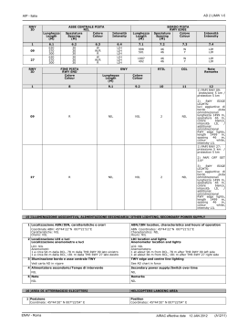
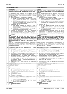
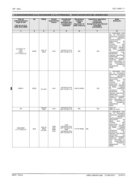
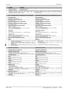
AD 2 LICJ 1-1
AIP - Italia
1 LICJ
Indicatore di località
Location indicator
PALERMO/Punta Raisi
Nome dell’ Aeroporto
Aerodrome name
2 DATI AMMINISTRATIVI E GEOGRAFICI DELL’AEROPORTO
AERODROME GEOGRAPHICAL AND ADMINISTRATIVE DATA
1 Coordinate ARP
38°10'55''N 013°05'58''E
2 Direzione e distanza dalla città
19 NM W NW
3 Elevazione/Temperatura di riferimento
65 FT / 28.8 °C
4 Ondulazione del geoide
143 FT
5 Variazione magnetica/Variazione annuale
2° E (2005.0) / 5'E
6 Autorità amministrativa aeroportuale
ENAC - DA Sicilia Occidentale
Aeroporto "Falcone e Borsellino"
90045 Punta Raisi, Cinisi (Palermo)
Tel + 39 091 7020/111/619/620 fax +39 091 591023
E-mail: [email protected]
Ufficio di PALERMO/Punta Raisi
Tel: +39 091 591414/591400/7020396/7020397
Fax: +39 091 7020398
ARP coordinates
38°10'55''N 013°05'58''E
Direction and distance from city
19 NM W NW
Elevation/Reference temperature
65 FT / 28.8 °C
Geoid undulation
143 FT
Magnetic variation/Annual change
2° E (2005.0) / 5'E
Aerodrome administration authority
ENAC - DA Sicilia Occidentale
Aeroporto "Falcone e Borsellino"
90045 Punta Raisi, Cinisi (Palermo)
Tel + 39 091 7020/111/619/620 fax +39 091 591023
E-mail: [email protected]
PALERMO/Punta Raisi office
Tel: +39 091 591414/591400/7020396/7020397
Fax: +39 091 7020398
Esercente
GESAP Tel +39 091 7020111; Fax +39 091 7020394
e-mail: [email protected]; internet: www.gesap.it
GESAP Apron Service: Tel +39 091 7020732/7020733
Fax +39 091 7020726
e-mail: [email protected]
SITA PMOAMXH
Aerodrome operator
GESAP Tel +39 091 7020111; Fax +39 091 7020394
e-mail: [email protected]; internet: www.gesap.it
GESAP Apron Service: Tel +39 091 7020732/7020733
Fax +39 091 7020726
e-mail: [email protected]
SITA PMOAMXH
Autorità ATS
ENAV S.p.A. - Centro Aeroportuale Palermo
Tel: +39 091 7043028; fax: +39 091 7043006
e-mail: [email protected]
7 Tipo di traffico consentito (IFR/VFR)
IFR/VFR
8 Note
1)
Codice di riferimento Annesso 14 per infrastrutture di volo: 4E
2)
Aeromobili con codice ICAO “F”: necessaria informazione e
preventiva autorizzazione da parte del gestore GESAP S.p.A.
ATS authority
ENAV S.p.A. - Centro Aeroportuale Palermo
Tel: +39 091 7043028; fax: +39 091 7043006
e-mail: [email protected]
Type of traffic permitted (IFR/VFR)
IFR/VFR
Remarks
1)
REF code Annex 14 flight infrastructure: 4E
2)
Aircraft ICAO code “F”: information and previous authorization
by aerodrome operator GESAP S.p.A. are requested
3 ORARIO DI SERVIZIO
OPERATIONAL HOURS
1 Amministrazione aeroportuale
H24
2 Dogana e immigrazione
H24
3 Servizio sanitario
H24
4 AIS Briefing Office
H24 ARO CBO ROMA
5 ARO
H24 ARO CBO ROMA
6 METEO Briefing Office
H24 ARO CBO ROMA
7 ATS
H24
8 Rifornimento
SKYTANKING srl: JET A1 - HR: 0400-2200 (0300-2100) tutti i giorni
In orari diversi il servizio è disponibile con 24 ore di preavviso
chiamando il responsabile della società (tel +39 091 591403 – fax
+39 091 591118) tutti i giorni nei seguenti orari: 0700-1500 (06001400)
Per richieste di rifornimento per voli ambulanza/soccorso o dirottati
in orari diversi, sarà possibile avvisare l’operatore ai seguenti
numeri: +39 366 1035434, +39 366 5489366. Se non raggiungibili,
contattare il Capo impianto al +39 324 5937807
Aerodrome Administration
H24
Customs and immigration
H24
Health and sanitation
H24
AIS Briefing Office
H24 ARO CBO ROMA
ARO
H24 ARO CBO ROMA
METEO Briefing Office
H24 ARO CBO ROMA
ATS
H24
Fuelling
SKYTANKING srl: JET A1- HR: 0400-2200 (0300-2100) every day
In different hours service available prior 24 hours notice calling the
company manager (tel +39 091 591403 – fax +39 091 591118)
during the following hours: 0700-1500 (0600-1400)
ENAV - Roma
For fuelling request of rescue/ambulance or diverted flights in
different hours, contact the operator at following numbers:
+39 366 1035434, +39 366 5489366. If not available, contact the
Local Supervisor at +39 324 5937807
18 FEB 2016
(2/16)
AD 2 LICJ 1-2
AIP - Italia
9 Handling
GH PMO HANDLING:
Tel +39 0917020665; fax +390917020237; e-mail [email protected]
Orario di servizio: MON H24, da TUE a SUN 0400-2300 (0300-2200)
AVIAPARTNER PALERMO S.R.L. HANDLING:
Tel
+390917020725;
Tel/fax
+390916529440;
e-mail
[email protected]
Orario di servizio: 0400-0000 (0300-2300)
GENAVIA S.R.L.:
Tel
+390916529472;
fax
+390916529702;
e-mail
[email protected]
Orario di servizio: H24; 0300-0700 (0200-0600) chiamando il
numero +39 393 9307519
GESAP S.p.A. (Handling Magazzino Merci):
Tel
+390917020504;
fax
+390917020537;
e-mail
[email protected]
Orario di servizio: 0430-0000 (0330-2300)
X-PRESS: (Handling Magazzino Merci)
Tel
+390917020569;
fax
+390917020553;
e-mail
[email protected]
Orario di servizio: 0500-2300 (0400-2200)
FLY SERVICE S.R.L.:
Tel +39 091 7852375; cell +39 346 0007492; fax +39 091
6190019; e-mail [email protected]
Orario di servizio: 0700-1900 (0600-1800)
Operazioni H24 O/R chiamando il numero +39 346 0007492
10 Servizi di sicurezza
H24
11 De-icing
NIL
12 Note
1)
ARO CBO ROMA: vedi GEN 3.1
4 SERVIZI DI SUPPORTO ED ATTREZZATURE
1 Attrezzatura di carico e scarico merci
Trattori, elevatori, carrelli
2 Tipi di carburante/Olio
JET A1 / 100 (SAE50) - 80 (SAE40), MOBILJET oil II
3 Capacità di rifornimento
JET A1: totale 1450 metri cubi, 6 autobotti 45 metri cubi
4 Sistema de-icing
NIL
5 Hangar per aeromobili in transito
NIL
6 Servizio riparazioni per aeromobili in transito
Contatti uffici ALITALIA CAI MAINTENANCE S.p.A.
Tel: + 39 091 595053, fax: + 39 091 6511300, e-mail scalo PMO:
[email protected]
Line Station Manager cell: + 39 335 1320328, email:
[email protected]
7 Note
1)
I piloti possono richiedere assistenza a terra tramite GESAP
gestore a:
a)
GESAP APRON SERVICE frequenza 131.575 MHz
b)
GH-PALERMO HANDLING frequenza 131.875 MHz
c)
AVIAPARTNER PALERMO S.R.L. HANDLING frequenza
131.650 MHz
d)
GENAVIA S.R.L. (solo Aviazione Generale) frequenza
131.700 MHz
2)
HANDLING SERVICES AND FACILITIES
Cargo-handling facilities
Tractors, elevators, trolleys
Fuel/Oil types
JET A1 / 100 (SAE50) - 80 (SAE40), MOBILJET oil II
Fuelling capacity
JET A1: total stockage 1450 cubic metres, 6 tank-trucks 45 cubic
metres
De-icing facilities
NIL
Hangar space for visiting aircraft
NIL
Repair facilities for visiting aircraft
Contact ALITALIA CAI MAINTENANCE S.p.A. offices
Tel: + 39 091 595053, fax: + 39 091 6511300, e-mail scalo PMO:
[email protected]
Line Station Manager mobile: + 39 335 1320328, e-mail:
[email protected]
Remarks
1)
Pilot may request ground assistance through the Management
Company (GESAP):
a)
GESAP APRON SERVICE frequency 131.575 MHz
b)
GH-PALERMO HANDLING frequency 131.875 MHz
c)
AVIAPARTNER PALERMO S.R.L. HANDLING frequency
131.650 MHz
d)
GENAVIA S.R.L. (only General Aviation) frequency
131.700 MHz
Servizio controllo e allontanamento volatili, orario H24, 2)
espletato mediante 1 persona con sistemi di dissuasione:
a)
Distress call e sistemi elettronici (DBDS) mobili e fissi
b)
c)
d)
3)
Handling
GH PMO HANDLING:
Tel
+390917020665;
fax
+390917020237;
e-mail
[email protected]
Operational hours: MON H24, from TUE to SUN 0400-2300 (03002200)
AVIAPARTNER PALERMO S.R.L. HANDLING:
Tel
+390917020725;
Tel/fax
+390916529440;
e-mail
[email protected]
Operational hours: 0400-0000 (0300-2300)
GENAVIA S.R.L.:
Tel
+390916529472;
fax
+390916529702,
e-mail
[email protected]
Operational hours: H24; 0300-0700 (0200-0600) calling number
+39 393 9307519
GESAP S.p.A. (Warehouse Cargo Handling):
Tel
+390917020504;
fax
+390917020537;
e-mail
[email protected]
Operational hours: 0430-0000 (0330-2300)
X-PRESS: (Warehouse Cargo Handling)
Tel
+390917020569;
fax
+390917020553;
e-mail
[email protected]
Operational hours: 0500-2300 (0400-2200)
FLY SERVICE S.R.L.:
Tel +39 091 7852375; mob +39 346 0007492; fax +39 091
6190019; e-mail [email protected]
Operational hours: 0700-1900 (0600-1800)
Operations H24 O/R calling number +39 346 0007492
Security
H24
De-icing
NIL
Remarks
1)
ARO CBO ROMA: see GEN 3.1
Pistole a salve
Cannoni a gas
Sirene
AVOIL 80/100 quantitativo limitato
3)
Control and keep out birds service, HR H24, carried out by 1
dedicated person with dissuasion and eviction devices:
a)
Distress call and electronic systems (DBDS) portable and
fixed
b)
Blank firing guns
c)
Gas cannons
d)
Alarm calls
AVOIL 80/100 limited amount
5 SERVIZI PER I PASSEGGERI
PASSENGER FACILITIES
1 Alberghi
In città
2 Ristoranti
Tavola calda - Self-service
3 Trasporti
Taxi - autobus pubblico - treno metropolitano
4 Servizio medico
Presidio medico aeroportuale, 1 lettino e 2 bombole ossigeno.
Ospedali: Palermo città km 37, Partinico km 25
5 Banca e ufficio postale
Sì
Hotels
In town
Restaurants
Self service
Transportation
Taxi - bus - metropolitan train
Medical facilities
Aerodrome medical unit, 1 bed and 2 oxygen cylinders.
Hospitals: Palermo town km 37, Partinico km 25
Bank and Post office
Yes
18 FEB 2016
(2/16)
ENAV - Roma
AD 2 LICJ 1-3
AIP - Italia
6 Ufficio turistico
Sì
7 Note
1)
PRM (Passengers with Reduced Mobility) ASSISTANCE
(CE1107/2006):
Messaggi PAL (Passenger Assistance List) e CAL (Change
Assistance List)
SITA: PMORMXH
Tel: +39 091 7020239 - Fax: +39 091 7020287
e-mail: [email protected]
Tourist office
Yes
Remarks
1)
PRM (Passengers with Reduced Mobility) ASSISTANCE
(CE1107/2006):
PAL (Passenger Assistance List) e CAL (Change Assistance List)
messages
SITA: PMORMXH
Tel: +39 091 7020239 - Fax: +39 091 7020287
e-mail: [email protected]
6 SERVIZI ANTINCENDIO E DI SOCCORSO
RESCUE AND FIRE FIGHTING SERVICES
1 Categoria servizio antincendio aeroportuale
CAT 8 ICAO
2 Equipaggiamento per il soccorso
NIL
3 Rimozione aeromobili in difficoltà
NIL
4 Note
NIL
Aerodrome category for fire fighting
CAT 8 ICAO
Rescue equipment
NIL
Capability for removal of disabled aircraft
NIL
Remarks
NIL
7 DISPONIBILITA’
PISTE
STAGIONALE
E
SISTEMI
DI
PULITURA SEASONAL AVAILABILITY AND CLEARING
1 Equipaggiamenti di pulitura
Spazzapiste
2 Priorità
NIL
3 Note
1)
Le caratteristiche di aderenza delle piste 02/20 e 07/25 sono
misurate ogni 3 mesi con pellicola d’acqua artificiale di 1 mm,
utilizzando il GRIPTESTER MK1. Il coefficiente minimo di attrito
è G=0,43
Types of clearing equipment
Sweeper
Clearance priorities
NIL
Remarks
1)
RWY 02/20 and 07/25 adherence characteristic measurement
is measured every 3 months using self wetting film of 1 mm,
with GRIPTESTER MK1. Minimum friction coefficient is G=0,43
8 DATI RELATIVI AI PIAZZALI, ALLE VIE DI RULLAGGIO ED APRONS, TAXIWAYS AND CHECK LOCATIONS DATA
ALLE PIAZZOLE PROVA
1 Superficie e resistenza dell’area di stazionamento
Apron
Superficie: CONC
Resistenza: PCN 119 R/A/X/T
ENAV - Roma
Apron surface and strength
Apron
Surface: CONC
Strength: PCN 119 R/A/X/T
AIRAC effective date
04 FEB 2016
(A13/15)
AD 2 LICJ 1-4
AIP - Italia
2 Larghezza, superficie e resistenza delle TWY
A
Larghezza: 30 M
Superficie: CONC
Resistenza: PCN 105 R/A/X/T
B
Larghezza: 30 M
Superficie: Conglomerato bituminoso
Resistenza: PCN 68 F/A/X/T
C
Larghezza: 30 M
Superficie: Conglomerato bituminoso
Resistenza: PCN 63 F/A/X/T
D
Larghezza: 23 M
Superficie: Conglomerato bituminoso
Resistenza: PCN 120 F/A/X/T
E
Larghezza: 30 M
Superficie: CONC
Resistenza: PCN 112 R/A/X/T
F
Larghezza: 30 M
Superficie: Conglomerato bituminoso
Resistenza: PCN 67 F/A/X/T
G
Larghezza: 30 M
Superficie: Conglomerato bituminoso
Resistenza: PCN 53 F/A/X/T
H
Larghezza: 45 M
Superficie: Conglomerato bituminoso
Resistenza: PCN 120 F/A/X/T
J
Larghezza: 45 M
Superficie: Conglomerato bituminoso
Resistenza: NIL
L
Larghezza: 45 M
Superficie: Conglomerato bituminoso
Resistenza: PCN 53 F/A/X/T
M
Larghezza: 45 M
Superficie: Conglomerato bituminoso
Resistenza: PCN 63 F/A/X/T
N
Larghezza: 45 M
Superficie: Conglomerato bituminoso
Resistenza: PCN 71 F/A/X/T
S
Larghezza: 30 M
Superficie: Conglomerato bituminoso
Resistenza: PCN 57 F/A/X/T
T (TWY principale)
Larghezza: 45 M
Superficie: Conglomerato bituminoso
Resistenza: PCN 76 F/A/X/T
3 Localizzazione/Elevazione ACL
Vedi carta AD in vigore
4 Punto di controllo VOR/INS
NIL / NIL
ACL location/Elevation
See AD chart in force
VOR/INS checkpoints
NIL / NIL
5 Note
1)
TWY width, surface and strength
A
Width: 30 M
Surface: CONC
Strength: PCN 105 R/A/X/T
B
Width: 30 M
Surface: Bituminous conglomerate
Strength: PCN 68 F/A/X/T
C
Width: 30 M
Surface: Bituminous conglomerate
Strength: PCN 63 F/A/X/T
D
Width: 23 M
Surface: Bituminous conglomerate
Strength: PCN 120 F/A/X/T
E
Width: 30 M
Surface: CONC
Strength: PCN 112 R/A/X/T
F
Width: 30 M
Surface: Bituminous conglomerate
Strength: PCN 67 F/A/X/T
G
Width: 30 M
Surface: Bituminous conglomerate
Strength: PCN 53 F/A/X/T
H
Width: 45 M
Surface: Bituminous conglomerate
Strength: PCN 120 F/A/X/T
J
Width: 45 M
Surface: Bituminous conglomerate
Strength: NIL
L
Width: 45 M
Surface: Bituminous conglomerate
Strength: PCN 53 F/A/X/T
M
Width: 45 M
Surface: Bituminous conglomerate
Strength: PCN 63 F/A/X/T
N
Width: 45 M
Surface: Bituminous conglomerate
Strength: PCN 71 F/A/X/T
S
Width: 30 M
Surface: Bituminous conglomerate
Strength: PCN 57 F/A/X/T
T (Main TWY)
Width: 45 M
Surface: Bituminous conglomerate
Strength: PCN 76 F/A/X/T
Remarks
Perimetro area di stazionamento: luci blu
1)
Apron edge: blu lighting
9 GUIDA AI MOVIMENTI A TERRA E SISTEMI DI CONTROLLO E SURFACE MOVEMENT GUIDANCE AND CONTROL SYSTEM AND
SEGNALAZIONE
MARKINGS
1 Segnale di identificazione stand aeromobili, linee guida per
TWY e sistemi di guida per parcheggio a vista negli stand
degli aeromobili
Vedi carte AD e APD in vigore
2 Illuminazione e segnaletica per RWY e TWY
Vedi carte AD e APD in vigore
3 Barre d’arresto
Vedi carte AD e APD in vigore
4 Note
1)
In casi di indisponibilità del servizio di assistenza dei marshall
gli aeromobili in arrivo devono arrestarsi sulle TWY prima di
entrare nell’area di parcheggio
AIRAC effective date
04 FEB 2016 (A13/15)
Use of aircraft stand identification sign, TWY guide lines and
visual docking/parking guidance system of aircraft stands
See AD and APD charts in force
RWY and TWY markings and lights
See AD and APD charts in force
Stop bars
See AD and APD charts in force
Remarks
1)
In case of marshalling assistance service not available, arriving
aircraft must stop on the TWY before entering the parking area
ENAV - Roma
AD 2 LICJ 1-5
AIP - Italia
10 OSTACOLI AEROPORTUALI
AERODROME OBSTACLES
Nelle aree di avvicinamento e decollo
In approach and take off areas
1
Tipo di ostacolo
Elevazione
Segnaletica e Luci
Obstacle type
Elevation
Markings and Lights
b
RWY e Area
interessata
RWY and Area
affected
a
Nell’area di circuitazione e all’interno
dell’aerodromo
In circling area and at aerodrome
2
Coordinate
Tipo di ostacolo
Coordinate
Coordinates
Elevazione
Coordinates
Segnaletica e Luci
Obstacle type
Elevation
Marking and Lights
c
a
b
Vedi AOC in vigore
See AOC in force
11 INFORMAZIONI METEOROLOGICHE
3
METEOROLOGICAL INFORMATION
1 Ufficio METEO associato
UPM ROMA
2 Orario di servizio
H24
3 Ufficio responsabile preparazione TAF/Periodo di validità
UPM ROMA / 24H
4 Tipo di previsione per l’atterraggio/Intervallo di emissione
NIL / NIL
5 Briefing e consultazione fornita
Briefing: ARO CBO ROMA, telefono
Cosultazione: UPM ROMA, telefono
6 Documentazione di volo/Lingua usata
Carte, testi in linguaggio chiaro abbreviato
IT, EN
7 Carte e documentazione disponibili per consultazione
P, W, SWL
8 Mezzi aggiuntivi disponibili per l’informazione
Fax
9 Enti ATS destinatari delle informazioni
Palermo TWR, Palermo APP
10 Informazioni climatologiche e informazioni supplementari
1)
ARO CBO ROMA: vedi GEN 3.1
2)
UPM ROMA: vedi GEN 3.5
3)
Aeroporto frequentemente interessato da fenomeni di wind
shear orografico, in prevalenza con venti al suolo di 10-20 kt
da 150°-270° e maggiori di 15 kt da SW alla quota di 1500 m.
L’azione del Monte Pecoraro determina correnti discendenti,
divergenza al suolo e/o rotori, aventi grande variabilità spaziotemporale
12 CARATTERISTICHE FISICHE DELLE PISTE
Associated MET Office
UPM ROMA
Hours of service
H24
Office responsible for TAF preparation/Period of validity
UPM ROMA / 24H
Type of landing forecast/Interval of issuance
NIL / NIL
Briefing and consultation provided
Briefing: ARO CBO ROMA, telephone
Cosultation: UPM ROMA, telephone
Flight documentation/Language used
Charts, abbreviated plain language texts
IT, EN
Charts and other information available for briefing or
consultation
P, W, SWL
Supplementary
equipment
available
for
providing
information
Fax
ATS units provided with information
Palermo TWR, Palermo APP
Climatological information and additional information
1)
ARO CBO ROMA: see GEN 3.1
2)
UPM ROMA: see GEN 3.5
3)
Aerodrome frequently affected by terrain-induced wind shear
phenomena, mostly originated by winds having a 10-20 kt
intensity and a 150°-270° direction at ground level and a
higher than 15 kt intensity and SW direction at 1500 m. The
sheltering by MT Pecoraro originates a descending flow
associated with ground divergence and vortices which are
highly variable both in space and time
RUNWAY PHYSICAL CHARACTERISTICS
Designazione
NR RWY
Designation
QFU
Dimensioni RWY
Dimension of RWY
(M)
Resistenza e superficie di
RWY
Strength and surface of
RWY
1
2
3
4
02
022°
2068 x 45
PCN 88/F/A/X/T
Conglomerato bituminoso
Bituminous conglomerate
20
202°
2068 x 45
PCN 88/F/A/X/T
Conglomerato bituminoso
Bituminous conglomerate
07
065°
3326 x 60
PCN 78/F/A/X/T
Conglomerato bituminoso
Bituminous conglomerate
ENAV - Roma
Note
Remarks
Coordinate THR
THR coordinates
--Coordinate RWY END
RWY END Coordinates
--Ondulazione Geoide THR
THR Geoid Undulation
5
38°09'58.57''N
013°05'08.50''E
----------------------------38°10'59.91''N
013°05'42.93''E
----------------------------143 FT
38°10'59.91''N
013°05'42.93''E
----------------------------38°09'58.57''N
013°05'08.50''E
----------------------------143 FT
38°10'29.10''N
013°05'16.14''E
----------------------------38°11'09.82''N
013°07'17.24''E
----------------------------143 FT
THR ELEV, MAX TDZ ELEV
della RWY per APCH di
precisione
THR ELEV, MAX TDZ ELEV
of precision APCH RWY
AIRAC effective date
6
42.3 FT / 43 FT
21.8 FT / 38 FT
32.7 FT / 49 FT
04 FEB 2016
(A13/15)
AD 2 LICJ 1-6
AIP - Italia
Designazione
NR RWY
Designation
QFU
Dimensioni RWY
Dimension of RWY
(M)
Resistenza e superficie di
RWY
Strength and surface of
RWY
1
2
3
4
25
245°
3326 x 60
PCN 78/F/A/X/T
Conglomerato bituminoso
Bituminous conglomerate
Designazione
NR RWY
Designation
1
02
20
07
25
Designazione
NR RWY
Designation
1
Pendenza di
RWY-SWY
Slope
7
Longitudinale/Longitudinal:
vedi AOC in vigore/see AOC
in force
Trasversale/Transverse: NIL
Longitudinale/Longitudinal:
vedi AOC in vigore/see AOC
in force
Trasversale/Transverse: NIL
Longitudinale/Longitudinal:
vedi AOC in vigore/see AOC
in force
Trasversale/Transverse: NIL
Longitudinale/Longitudinal:
vedi AOC in vigore/see AOC
in force
Trasversale/Transverse: NIL
Coordinate THR
THR coordinates
--Coordinate RWY END
RWY END Coordinates
--Ondulazione Geoide THR
THR Geoid Undulation
5
38°11'07.19''N
013°07'09.40''E
----------------------------38°10'27.54''N
013°05'11.51''E
----------------------------143.1 FT
12
Non applicabile/Not
applicable
Non applicabile/Not
applicable
20
NIL
25
Non applicabile/Not
applicable
Dimensioni CWY
CWY dimension
(M)
9
Dimensioni strip
strip dimension
(M)
10
Dimensioni RESA
RESA dimension
(M)
11
NIL
118 x 150
2194 x 300
90 x 90
NIL
63 x 150
2194 x 300
90 x 90
NIL
150 x 150
3446 x 300
90 x 120
NIL
60 x 150
3446 x 300
120 x 120
Note
Remarks
13
1) Testate in calcestruzzo/heads in concrete - PCN 120 R/A/X/T
1) Testate in calcestruzzo/heads in concrete - PCN 120 R/A/X/T
2) Testate: lastroni in calcestruzzo/Heads: concrete slabs - PCN 120 R/A/X/T
1) DTHR 207 m
2) Testate: lastroni in calcestruzzo/Heads: concrete slabs - PCN 120 R/A/X/T
13 DISTANZE DICHIARATE
DECLARED DISTANCES
Designazione RWY
RWY designator
1
02
20
07
INT TAKE-OFF E
25
INT TAKE-OFF A
TORA
(M)
2
2068
2068
3326
3204
3326
3030
1)
2)
TODA
(M)
3
2186
2131
3476
3354
3386
3090
Tipo
Type
ASDA
(M)
4
2068
2068
3326
3204
3326
3030
APPROACH AND RUNWAY LIGHTING
AVVICINAMENTO
APPROACH
Lunghezza
Intensità
Length
Intensity
(M)
THR
VASIS
MEHT
(M)
TDZ
Lunghezza
Length
(M)
2.1
2.2
2.3
3
4.1
02
NIL
NIL
NIL
G
NIL
20
SALS
420
VRB
G
NIL
04 FEB 2016 (A13/15)
PAPI
Colore
Colour
1
AIRAC effective date
LDA
(M)
5
2068
2068
3204
3119
-
RWY 07/25: la segnaletica orizzontale di asse centrale delle TWY A ed E conduce alle posizioni di
Intersection Take-off (INT TAKE-OFF A ed E rispettivamente)/ TWY A and E centre line markings are leading
to Intersection Take-off positions (INT TAKE-OFF A and E respectively)
Le intere lunghezze pista sono disponibili su richiesta del pilota previa manovra di back-track/on pilot’s
request the whole RWY lengths are available previous back-track manouvre
14 LUCI DI AVVICINAMENTO E LUCI PISTA
RWY
ID
50.4 FT / 65 FT
1) DTHR 122 m
07
NOTE/REMARKS
6
Dimensioni SWY
SWY dimension
(M)
8
OFZ
Obstacle free zone (OFZ)
02
THR ELEV, MAX TDZ ELEV
della RWY per APCH di
precisione
THR ELEV, MAX TDZ ELEV
of precision APCH RWY
4.2
3°
wing bar
lato sinistro/
left side
3°
wing bar
entrambi i
lati/both
sides
4.3
5
16.0
NIL
20.0
NIL
ENAV - Roma
AD 2 LICJ 1-7
AIP - Italia
RWY
ID
Tipo
Type
AVVICINAMENTO
APPROACH
Lunghezza
Intensità
Length
Intensity
(M)
THR
VASIS
2.2
2.3
3
4.1
07
SALS
436
VRB
G
NIL
25
CALVERT
900
VRB
G
NIL
1
ASSE CENTRALE PISTA
RCL
Spaziatura
Colore
Spacing
Colour
(M)
6.1
1174
600
300
1174
600
300
2303
600
300
2220
600
300
02
20
07
25
RWY
ID
6.2
30
30
30
30
30
30
30
30
30
30
30
30
Intensità
Intensity
6.3
W
W/R
R
W
W/R
R
W
W/R
R
W
W/R
R
FINE PISTA
RWY END
Colore
Colour
TDZ
Lunghezza
Length
(M)
2.1
Lunghezza
Length
(M)
MEHT
(M)
Colore
Colour
1
RWY
ID
PAPI
Lunghezza
Length
(M)
6.4
VRB
VRB
VRB
VRB
VRB
VRB
VRB
VRB
VRB
VRB
VRB
VRB
4.2
3°
wing bar
lato sinistro/
left side
3°
wing bar
entrambi i
lati/both
sides
4.3
5
16.0
NIL
18.0
NIL
BORDO PISTA
RWY EDGE
Spaziatura
Colore
Spacing
Colour
(M)
Intensità
Intensity
7.1
7.2
7.3
7.4
1471
600
60
60
W
Y
VRB
VRB
1471
600
60
60
W
Y
VRB
VRB
120
2603
600
207
2519
600
60
60
30
60
60
30
R
W
Y
R
W
Y
VRB
VRB
VRB
VRB
VRB
VRB
RTIL
CGL
Note
Remarks
12
NIL
1) SALS: Crossbar
a/at 300m dalla/
from THR 20
NIL
NIL
SWY
Lunghezza
Length
(M)
Colore
Colour
1
02
8
R
9.1
NIL
9.2
NIL
10
NIL
11
NIL
20
R
NIL
NIL
Sì
Yes
NIL
07
25
R
R
NIL
NIL
NIL
NIL
NIL
NIL
NIL
NIL
15 ILLUMINAZIONE AGGIUNTIVA, ALIMENTAZIONE SECONDARIA OTHER LIGHTING, SECONDARY POWER SUPPLY
1 Localizzazione ABN/IBN, caratteristiche e orari
ABN/IBN location, characteristics and hours of operation
Coordinate ABN: 38°11'20''N 013°06'33''E
ABN Coordinates: 38°11'20''N 013°06'33''E
Caratteristiche: rotante a luci bianco/verde alternate
Characteristics: ABN revolving white/green alternating lights
Orario: HN-/+30
Hours: HN-/+30
Coordinate IBN: 38°11'05''N 013°06'07''E
IBN Coordinates: 38°11'05''N 013°06'07''E
Caratteristiche: luce verde, lettera Q emessa in codice Morse 7,5 volte Characteristics: IBN green light letter Q Morse flashed 7,5 times in
al minuto
1 minute
Orario: HN-/+30
Hours: HN-/+30
2 Localizzazione LDI e luci
Localizzazione anemometro e luci
LDI: NIL
Anemometri:
1) Circa 200 m
2) Circa 100 m
3) Circa 300 m
4) Circa 200 m
dopo THR 07,
dal gonio lato
dopo THR 02,
dopo THR 20,
lato sinistro RCL. Illuminato.
destro RCL RWY 25. Illuminato.
lato sinistro RCL. Illuminato.
lato destro RCL. Illuminato.
3 Illuminazione bordo e asse centrale TWY
Vedi carta AD in vigore
4 Alimentatore secondario/Tempo di intervento
Luci RWY 02/20 e 07/25: 1 s
PAPI RWY 07/25 e RWY 20: 1 s
SALS RWY 07: 1 s
SALS RWY 20: 50% circuito 1 s, altro 50% circuito 15 s
CALVERT RWY 25: 1 s
RTIL RWY 20: 15 s
ABN/IBN: 15 s
5 Note
1)
Luci di emergenza: proiettori
16 AREA DI ATTERRAGGIO ELICOTTERI
1 Posizione
NIL
2 Elevazione
NIL
ENAV - Roma
LDI location and lights
Anemometer location and lights
LDI: NIL
Anemometers:
1) About 200 m after THR 07, left side RCL. Lighted.
2) About 100 m from homer right side RCL RWY 25. Lighted.
3) About300 m after THR 02, left side RCL. Lighted.
4) About 200 m after THR 20, right side RCL. Lighted.
TWY edge and centre line lighting
See AD chart in force
Secondary power supply/Switch over time
RWY 02/20 e 07/25 lights: 1 s
PAPI RWY 07/25 and RWY 20: 1 s
SALS RWY 07: 1 s
SALS RWY 20: 50% circuit 1 s, other 50% circuit 15 s
CALVERT RWY 25: 1 s
RTIL RWY 20: 15 s
ABN/IBN: 15 s
Remarks
1)
Emergency lights: flood light
HELICOPTERS LANDING AREA
Position
NIL
Elevation
NIL
AIRAC effective date
04 FEB 2016
(A13/15)
AD 2 LICJ 1-8
AIP - Italia
3 Dimensioni, superficie, resistenza, segnaletica
NIL
4 Orientamento
NIL
5 Distanze dichiarate
NIL
6 Luci
NIL
7 Note
1) Le operazioni di atterraggio e decollo sono consentite su RWY and
TWY
Dimensions, surface, strength, marking
NIL
Bearing
NIL
Declared distances
NIL
Lighting
NIL
Remarks
1) Landing and take off operations allowed on the RWY and TWY
17 SPAZIO AEREO ATS
ATS AIRSPACE
Designatore e limiti laterali
Designation and lateral limits
Limiti
verticali
Vertical
limits
Classificazione dello
spazio aereo
Airspace
classification
1
Palermo Punta Raisi ATZ
Cerchio di raggio/Circle of radius 5.0
NM
centrato su/centred on:
38°10'47''N 013°06'13''E
2
3
2000 FT
AGL
D
18 SERVIZI DI COMUNICAZIONE ATS
Servizio
Service
1
Emergenza
Emergency
APP
ATIS
Nominativo
Call sign
2
Frequenza MHZ
Frequency MHZ
3
NIL
121.500 MHZ
Palermo APP
VDF
AIRAC effective date
5
6
Raisi TWR
EN / IT
5000 FT
1) WI Palermo CTR
Note
Remarks
5
H24
Raisi GND
118.650
120.200
118.650
120.200
121.625
Raisi TWR
119.050 MHZ
H24
Palermo ATIS
123.875 MHZ
H24
MHZ
MHZ
MHZ
MHZ
MHZ
NIL
vedi note/see remarks
H24
vedi note/see remarks
H24
0600-2200 (0500-2100)
1) A discrezione ATC / ATC discrection
NIL
1) A discrezione ATC / ATC discrection
NIL
NIL
1) Copertura non assicurata nel settore SUD /
Coverage not assured in SOUTH sector
1) Copertura operativa nominale/Designated
operational coverage 60NM/20000ft
2) Disponibile al tel/available by phone:+39
091 7043090
3)
Il
messaggio
emette
informazioni
aggiornate in tempo reale/broadcast message
issues real time updated information
4) I piloti sono tenuti all'ascolto dell'ATIS
prima di stabilire il contatto radio con Raisi
TWR/GND o Palermo APP e di riportare all'ATC
il codice indicativo ATIS/pilots are required to
listen to ATIS prior to establishing radio
contact with Raisi TWR/GND or Palermo APP
and report to ATC the ATIS code designator
5) Il messaggio ATIS ARR/DEP fornisce il
vento in superficie sulla TDZ della RWY in
uso/ATIS ARR/DEP messages provide surface
wind on TDZ of RWY in use
RADIO NAVIGATION AND LANDING AIDS
ID
FREQ
Orario
Operational
hours
Coordinate
antenna
Antenna site
coordinates
(WGS84)
Elevazione
antenna
DME
Elevation of
DME antenna
Copertura operativa
nominale
Limitazioni
Designated operational
coverage
Limitations
Note
Remarks
2
3
4
5
6
7
8
CAT di/of ILS
(VAR ILS/VOR)
1
Note
Remarks
Orario
Operational hours
4
19 RADIOASSISTENZE ALLA NAVIGAZIONE E ALL’ATTERRAGGIO
Tipo di
radioassistenza
Type of aid
Altitudine di
transizione
Transition
altitude
ATS COMMUNICATION FACILITIES
Palermo radar
TWR
Nominativo
dell’unità ATS
Lingua
ATS unit call sign
Language
4
Raisi Gonio
Homer
NIL
04 FEB 2016 (A13/15)
H24
38°11'14.3''N
013°06'49.9''E
NIL
1) Copertura non
assicurata
nel
settore
SUD
/
Coverage
not
limitazioni entro/limitations assured in SOUTH
within 30 NM
sector
090°/100° MRA 5500 FT
100°/200° NU
2) Disponibile su
200°/230° MRA 8500 FT
richiesta su tutte le
230°/260° MRA 7500 FT
frequenze di TWR/
260°/090° MRA 1500 FT
APP ed emergenza /
Available
on
request on all TWR/
APP and emergency
frequencies
ENAV - Roma
AD 2 LICJ 1-9
AIP - Italia
Tipo di
radioassistenza
Type of aid
ID
FREQ
Orario
Operational
hours
Coordinate
antenna
Antenna site
coordinates
(WGS84)
Elevazione
antenna
DME
Elevation of
DME antenna
Copertura operativa
nominale
Limitazioni
Designated operational
coverage
Limitations
2
3
4
5
6
7
CAT di/of ILS
(VAR ILS/VOR)
1
ILS RWY 20
LOC
CAT I
(2° E-2005.0)
ITO
DME
ITO
GP
-
PAL
VOR/DME
(2° E-2005.0)
NDB
TVOR/DME
(2° E-2005.0)
L
PAL
PRS
PRS
110.55
MHZ
H24
38°09'54.0''N
013°05'05.9''E
NIL
38°10'53.3''N
013°05'32.1''E
11 M AMSL
329.45
MHZ
H24
38°10'53.1''N
013°05'33.1''E
NIL
112.30
MHZ
CH 70X
VOR
H24
DME
H24
VOR
38°02'00.9''N
013°10'38.8''E
DME
38°02'01.3''N
013°10'38.9''E
355.50
KHZ
113.00
MHZ
CH 77X
329.00
KHZ
H24
38°02'03.4''N
013°10'38.6''E
TVOR
H24
DME
H24
TVOR
38°10'19.4''N
013°04'47.6''E
DME
38°10'19.4''N
013°04'47.3''E
H24
38°11'23.0''N
013°06'35.6''E
8
1) Fascio posteriore
non
utilizzabile/
back
beam
not
usable
H24
CH 42Y
Note
Remarks
NIL
2) MAINT:
primo FRI di ogni
mese/first FRI each
month: 0745-0845
(0645-0745)
25 NM/10000 FT
limitazioni entro/limitations
within 10 NM
060°/110° MRA 10000 FT
110°/150° NU
150°/190° MRA 7000 FT
NIL
190°/270° MRA 3000 FT
limitazioni a/limitations at
25 NM
060°/270° NU
270°/060° MRA 2000 FT
Slope 3°
RDH:17.50 M
NIL
200 NM/50000 FT
limitazioni a/limitations
40 NM
1193 M AMSL 090°/140° MRA 8000 FT
140°/240° MRA 7000 FT
240°/340° MRA 6000 FT
340°/090° MRA 7000 FT
NIL
12 M AMSL
NIL
150 NM
limitazioni
25 NM
095°/170°
limitazioni
50 NM
000°/095°
170°/260°
260°/360°
a/limitations
1) MAINT VOR:
at primo MON di ogni
mese / first MON
each month: 09001030 (0800-0930)
at
MRA 11000 FT
1) 095°/170°: COV
a/limitations at ridotta a/reduced at
25 NM
MRA 10000 FT
MRA 5000 FT
MRA 6000 FT
40 NM/25000 FT
limitazioni entro/limitations
within 10 NM
090°/130° MRA 11000 FT
limitazioni oltre/limitations
beyond 10 NM
090°/130° NU
limitazioni a/limitations at
25 NM
060°/090° MRA 9000 FT
130°/170° MRA 18000 FT
170°/220° MRA 10000 FT
220°/270° MRA 8000 FT
270°/060° MRA 3000 FT
25 NM
limitazioni a/limitations
25 NM
090°/260° NU
260°/090° MRA 2000 FT
at
1)
RAISI:
identificativo
da
usarsi
nelle
comunicazioni G/A/
G identification to
be used in G/A/G
communications
2) MAINT VOR:
primo TUE di ogni
mese / first TUE
each month:
0745-0845 (06450745)
NIL
1) Fascio posteriore
non
utilizzabile/
back
beam
not
usable
ILS RWY 25
LOC
CAT I
(2° E-2005.0)
RAI
109.50
MHZ
H24
38°10'25.2''N
013°05'04.5''E
NIL
NIL
2) Entro 17 NM
settore
avvicinamento
utilizzabile
a
sinistra RCL ridotto
a 15° con MRA
3500 ft, oltre 17 NM
MRA 5000 ft /
Within 17 NM left
side RCL reduced at
15° MRA 3500 ft,
beyond 17 NM MRA
5000 ft
3) MAINT:
primo WED di ogni
mese/first
WED
each month: 07450845 (0645-0745)
ENAV - Roma
AIRAC effective date
04 FEB 2016
(A13/15)
AD 2 LICJ 1-10
AIP - Italia
Tipo di
radioassistenza
Type of aid
ID
FREQ
Orario
Operational
hours
Coordinate
antenna
Antenna site
coordinates
(WGS84)
Elevazione
antenna
DME
Elevation of
DME antenna
Copertura operativa
nominale
Limitazioni
Designated operational
coverage
Limitations
2
3
4
5
6
7
CAT di/of ILS
(VAR ILS/VOR)
1
DME-P
RAI
GP
-
CH 32X
332.60
MHZ
H24
H24
38°10'58.9''N
013°07'01.0''E
38°10'59.7''N
013°07'00.6''E
22 M AMSL
NIL
NIL
NIL
Note
Remarks
8
1) Utilizzabile solo
entro la copertura
ILS RWY25 / Usable
only within ILS RWY
25 coverage
2)Funzionalità Final
approach
non
utilizzabile.
Per
maggiori
informazioni
vedi
GEN
3.4/Final
approach mode not
usable. For more
information
see
GEN 3.4
1) Fascio posteriore
non
utilizzabile/
Back
beam
not
usable
2)
Copertura
a
sinistra limitata a
6°da RCL/Left side
coverage limited to
6° from RCL
3) MAINT:
primo THU di ogni
mese/first
THU
each month: 07450800 (0645-0700)
4)Slope 3°
RDH:17.50 M
MM
-
VORTAC
(2° E-2005.0)
NDB
75.00
MHZ
TRP
108.80
MHZ
CH 25X
TRP
317.50
KHZ
H24
38°11'20.0''N
013°07'47.3''E
VOR
H24
TACAN
H24
VOR
37°53'45.5''N
012°30'47.5''E
TACAN
37°53'45.5''N
012°30'48.2''E
H24
37°54'51.6''N
012°29'34.7''E
20 REGOLAMENTI DEL TRAFFICO LOCALE
NIL
NIL
NIL
43 M AMSL
VOR
80 NM/50000 FT
limitazioni a/limitations at
40 NM
140°/200° MRA 6000 FT
200°/350° MRA 4000 FT
1) MAINT:
350°/140° MRA 10000 FT
primo TUE di ogni
mese / first TUE
TACAN
each month: 1000200 NM/60000 FT
1200 (0900-1100)
limitazioni a/limitations at
40 NM
140°/200° MRA 6000 FT
200°/350° MRA 4000 FT
350°/140° MRA 10000 FT
NIL
50 NM
1) MAINT:
limitazioni a/limitations at primo WED di ogni
50 NM
mese / first WED
000°/130° MRA 10000 FT
each month: 0800130°/360° MRA 2000 FT
1000 (0700-0900)
LOCAL TRAFFIC REGULATIONS
1 Uso preferenziale delle piste
1)
RWY 02:
a)
HJ disponibile per atterraggi solo in VMC
b)
HN non disponibile per atterraggi
2 Apron
1)
Follow-me disponibile O/R
2)
Per i voli militari è richiesta la pianificazione e l’assegnazione
degli stands da parte di GESAP Apron Operation Service, HR H24,
tel +39 091 7020733, fax +39 091 7020726
3)
L’ordinato movimento degli aeromobili sui piazzali è fornito su
base sperimentale dall’ENAV S.p.A. (Società Italiana per i Servizi
della Navigazione Area) in collaborazioe con il gestore in accordo
alla disposizione del Codice della Navigazione Area (Artt. 691bis e
605) con le seguenti caratteristiche:
a)
L’ordinato movimento degli aeromobili sui piazzali è
obbligatorio per tutti gli aeromobili all’interno dei limiti
dell’area del piazzale (vedi AIP AD 2 LICJ 2-5)
b)
Orario di servizio: H24
c)
Nominativi:
- ‘Raisi Ground’ sulla FREQ 121.625 MHz, orario 0600-2200
(0500-2100)
- ‘Raisi Tower’ sulla FREQ 119.050 MHz, orario H24
- ‘Apron Service’ sulla FREQ di GESAP S.p.A. 131.575 MHz
d)
Runway preferential use
1)
RWY 02:
a)
HJ available for landing in VMC only
b)
HN not available for landing
Apron
1)
Follow-me AVBL O/R
2)
Military flights are required stand planning and allocation by
GESAP Apron Operation Service, HR H24, tel +39 091
7020733, fax +39 091 7020726
3)
Orderly movement of traffic on aprons is provided on trial
basis by ENAV S.p.A. (Italian Company for Air Navigation
Services) in collaboration with the aerodrome operator
according to provision of Air Navigation Act (Artt. 691-bis and
705) with following characteristics:
a)
Orderly movement of traffic on aprons is mandatory for
all aircraft within apron area limits (see AIP AD 2 LICJ 25)
b)
Operational hours: H24
c)
Call signs:
- ‘Raisi Ground’ on FREQ 121.625 MHz, operational
hours 0600-2200 (0500-2100)
- ‘Raisi Tower’ on FREQ 119.050 MHz, operational hours
H24
- ‘Apron Service’ on GESAP S.p.A. FREQ 131.575 MHz
Servizio fornito sull’area del piazzale:
d)
Service provided on apron area:
ENAV S.p.A. assicura l’ordinato movimento degli aeromobili
ENAV S.p.A. ensures the orderly movement of aircraft as
come segue:
follows:
AIRAC effective date
04 FEB 2016 (A13/15)
ENAV - Roma
AD 2 LICJ 1-11
AIP - Italia
-
gli aeromobili in arrivo riceveranno:
- istruzioni al rullaggio al piazzale con l’indicazione
dello stand assegnato
- procedure di handling solo dopo che sia stata emessa
dal gestore la comunicazione ‘aircraft on blocks’
-
gli aeromobili in partenza riceveranno:
- istruzioni al push-back e rullaggio dal piazzale solo
dopo che sia stata emessa dal gestore la
comunicazione di ‘aircraft ready’
- istruzioni al rullaggio sul piazzale e raggiungimento
delle taxiways
e)
Il gestore assicura l’ordinato movimento dei veicoli,
equipaggiamenti e personale per non interferire con il
movimento degli aeromobili
REMARKS:
(1) Lo stato ‘aircraft on blocks’ è riportato dal gestore quando
sono soddisfatte le seguenti condizioni:
- l’aeromobile è posizionato sullo stand assegnato
- tutti i motori sono stati spenti
- le luci anti-collisione sono spente
- l’aeromobile è ai blocchi
(2) Lo stato ‘aircraft ready’ è riportato dal gestore quando
sono soddisfatte le seguenti condizioni:
- porte di carico chiuse
- eventuale loading-bridge retratto
- area degli stand degli aeromobili libera da veicoli,
equipaggiamenti e personale
- aeromobile pronto a rullare o al push-back
(3) Alla ricezione delle istruzioni per il push-back il pilota
dovrà inziare la manovra senza ritardo
(4) All’aeromobile è consentito di uscire o entrare dagli stand
solo se il pilota ha in vista il marshall
3 Norme per l’utilizzo delle vie di rullaggio
1)
Il rullaggio degli elicotteri da/per la piazzola 313 è consentito solo
via TWY H o TWY J
2)
Durante le operazioni di rullaggio è fatta richiesta ai piloti di
tenere il transponder spento o in stand-by
3)
Procedura di avaria radio in area di manovra
Ogniqualvolta un aeromobile che operi sull’area di manovra si
trovi in una situazione di avaria radio, indipendentemente dalle
condizioni di visibilità in atto, dovrà comportarsi come segue:
a)
Aeromobile in partenza:
continuerà sul percorso assegnato, ponendo particolare
attenzione nell'evitare ogni deviazione, fino a raggiungere la
posizione corrispondente alla sua clearance limit, dove rimarrà in
attesa del follow-me per ritornare al parcheggio
b)
Aeromobile in arrivo:
libererà la pista come indicato e rimarrà in attesa del follow-me
per il parcheggio
sulla taxiway E con atterraggio RWY 25
sulla taxiway A con atterraggio RWY 07
sulla taxiway T con atterraggio RWY 02
sulla taxiway G con atterraggio RWY 20
4 Procedure applicabili agli aeromobili in condizioni di visibilità
ridotta (AWO)
1) Generalità
Le procedure di bassa visibilità (LVP) saranno applicate alle operazioni
di avvicinamento ed atterraggio di precisione ed alle operazioni di
decollo alle seguenti condizioni:
a)
quando il valore di runway visual range (RVR) riportato al
touchdown zone (TDZ) è uguale o inferiore a 550 m; e/o
b)
quando la base delle nubi è inferiore a 200 ft in accordo al
locale riporto meteorologico; e/o
c)
quando il rapido deterioramento delle condizioni meteo ne
raccomanda l’attivazione.
I piloti saranno informati dell’attivazione delle LVP tramite ATIS e/o via
radiotelefonia.
La pista 20 è abilitata ad operazioni di CAT I e decolli
con valori di RVR non inferiore a 400 m
-
La pista 25 è abilitata ad operazioni di CAT I e decolli
con valori di RVR non inferiore a 400 m
La pista 07 è abilitata ai decolli con valori di RVR non
inferiori a 400 m
La pista 02 è abilitata ai decolli con valori di RVR non
inferiori a 400 m
Non sono consentite operazioni con RVR inferiore a 400 m.
In condizioni di scarsa visibilità è prevedibile una riduzione della
capacità aeroportuale a causa dell'aumentato spaziamento tra
successivi aeromobili in arrivo e delle restrizioni applicate alla
movimentazione al suolo.
2) Movimentazione al suolo
Qualora le condizioni siano tali da non permettere alla TWR il
monitoraggio visivo di tutta o parte dell'area di manovra, la
movimentazione degli aeromobili sull'area di movimento sarà ristretta
ad un solo movimento per volta
3) Assistenza Follow-me
L' assistenza del Follow-me sarà disponibile su richiesta dell'equipaggio
di condotta
ENAV - Roma
-
arriving aircraft will receive:
- instructions to taxi to the apron with indication of
assigned aircaft stand
- handling procedures only after ‘aircraft on blocks’
communication has been issued by aerodrome
operator
departing aircraft will receive:
- instructions to push-back and taxi from the apron
only after ‘aircraft ready’ communication has been
issued by the aerodrome operator
- instructions to taxi on the apron and reach the
taxiways
e)
Aerodrome operator ensures the orderly movement of
vehicles, equipment and personnel in order not to
interfere with movement of aircraft
REMARKS:
(1) The status ‘aircraft on blocks’ is reported by aerodrome
operator when the following conditions are met:
- aircraft is positioned at assigned aircraft stand
- all engines have been switched off
- anti-collision lights are off
- aircraft in on blocks
(2) The status ‘aircraft ready’ is reported by the aerodrome
operator when the following conditions are met:
- loading doors closed
- loading bridge, if any, retracted
- aircraft stand area free of vehicles, equipment and
personnel
- aircraft ready to taxi or push-back
(3) On receiving instructions for push-back pilot shall start
manoeuvring without delay
(4) Aircraft is allowed to leave or enter the aircraft stand
only if the pilot has the marshall in sight
Special rules for taxiway use
1)
Helicopters taxiing to/from stand 313 available only via TWY
H or TWY J
2)
During taxiing operations pilots are requested to keep the
transponder off or stand-by
3)
Communication failure procedure in the manoeuvring area
Whenever an aircraft operating in the manoeuvring area
experiences a communication failure, it shall comply with the
following:
a)
Departing aircraft:
it shall continue taxiing along the assigned route to the
clearance limit position, paying particular attention to avoid
any diversion, and wait for the arrival of the follow-me car in
order to be guided back to the stand
b)
Arriving aircraft:
it shall vacate the runway as indicated and wait for the arrival
of the follow-me car in order to be guided to the stand
via TWY E for landing RWY 25
via TWY A for landing RWY 07
via TWY T for landing RWY 02
via TWY G for landing RWY 20
Aircraft procedures in reduced visibility conditions (AWO)
1) General
Low visibility procedures (LVP) will be applied to
precision
approach and landing operations and departure operations at the
following conditions:
a)
when the runway visual range (RVR) value reported at
touchdown zone (TDZ) is 550 m or below; and/or
b)
when clouds base height is below 200 ft according to the
meteorological local report; and/or
c)
when the rapid deterioration of weather conditions
recommends so.
Pilots will be informed by RTF and/or ATIS when LVP are in force.
-
Runway 20 is suitable for approach and landing
operations in CAT I and departure operations with
RVR not less than 400 m
Runway 25 is suitable for approach and landing
operations in CAT I and departure operations with
RVR not less than 400 m
Runway 07 is suitable for departure operations with
RVR not less than 400 m
Runway 02 is suitable for departure operations with
RVR not less than 400 m
No operations allowed with RVR less than 400 m
In case of poor visibility conditions a reduced airport capacity can
be expected due to the required increase in spacing between
arriving aircraft and the restrictions applied on ground movements.
2) Ground movement
Whenever conditions are such that all or part of the manoeuvring
area cannot be visually monitored from the TWR, only
one
movement at a time is allowed
3) Follow-me assistance
Follow-me assistance will be available on pilot’s request
18 FEB 2016
(2/16)
AD 2 LICJ 1-12
AIP - Italia
5 Operazioni per l’utilizzo della pista nel tempo strettamente
necessario
NIL
6 Restrizioni locali ai voli
NIL
7 Disposizioni per gli aeromobili dell’aviazione generale
1)
Tutti i voli privati e gli aerotaxi dell’Aviazione Generale, nonchè
tutti gli aeromobili che svolgono attività di volo addestramento,
che intendono operare sull’aeroporto di Palermo/Punta Raisi
anche con attività di “Stop&Go”, ad eccezione degli aeromobili di
base, devono essere preventivamente autorizzati da GESAP.
L’autorizzazione, richiesta alla relativa compagnia handling, deve
essere presentata all’ufficio preposto Unità Operativa Apron HR
0500-2230 (0400-2130)
2)
Le compagnie handling per l’aviazione generale sono: vedi
tabella 3, item 9
3)
Per soste di massimo 2 HR, la richiesta deve essere inoltrata
minimo 2 HR prima dell’ETA, per soste superiori alle 2 HR, la
richiesta deve essere inoltrata almeno 12 HR prima dell’ETA. Il
parcheggio lunga sosta non deve superare le 72 HR
4)
Il numero PPR deve essere incluso nel campo 18 del piano di volo
per i voli IFR; per i voli VFR o per quelli senza piano di volo il
numero PPR deve essere mostrato allo staff dell’apron
management
Special operational practice for minimum RWY occupancy
NIL
Local flight restrictions
NIL
Provisions for general aviation aircraft
1)
Except based aircraft, all General Aviation private flights and
air taxis, as well as all aircraft performing flight training
activity, which intend to operate on Palermo/Punta Raisi
airport even with “Stop&Go” activity, must be previously
cleared by GESAP. The clearance, requested to the relevant
handling company, must be submitted to Apron Management
Office from 0500 to 2230 (0400-2130)
2)
General Aviation handling companies: see table 3, item 9
3)
For parking stop of MAX 2 HR, the request must be forwarded
at least 2 HR prior to ETA, for a stop of more than 2 HR the
request must be forwarded at least 12 HR prior to ETA. The
long term parking must not exceed 72 HR
The PPR number must be included in FPL item 18 for IFR
flights; for VFR flights or for flights without FPL the PPR
number must be shown to apron management staff
4)
21 PROCEDURE ANTIRUMORE
NOISE ABATEMENT PROCEDURES
1 Generalità
Oltre a quanto riportato nella presente tabella si rimanda alla sezione
ENR 1.5 della normativa generale
2 Uso delle piste
1) Partenze
NIL
2) Arrivi
Nelle ore notturne, dalle 2200 (2100) alle 0500 (0400), tutti i
velivoli in atterraggio devono utilizzare l'intera pista di volo per
portarsi alle zone di sosta.
3) Restrizioni notturne
NIL
3 Restrizioni al suolo
1) Spinta inversa
Le manovre di power-back sui piazzali sono di regola proibite.
Eventuali manovre di power-back devono essere condotte previa
apposita autorizzazione rilasciata da Apron Service tramite
Handler su frequenza 440.600 MHz. La manovra di power-back,
se approvata, deve essere eseguita con minima potenza motori
del velivolo, sufficiente all'avvio ed al prosieguo del movimento
2) APU
L’APU (Auxiliary Power Unit) deve essere acceso non prima di 60
minuti dall'orario schedulato di partenza del velivolo e deve
essere spento non oltre 20 minuti dall'arrivo del velivolo
3) Prove Motori
a)
Le prove motori devono essere effettuate in area di
manovra in posizione decentrata dal traffico
b)
Nella fascia oraria che va dalle ore 2000 (1900) alle ore
0600 (0500) e dalle ore 1300 (1200) alle ore 1600 (1500)
non possono essere effettuate le prove motori, salvo che si
tratti
di
velivoli
che
devono
essere
impiegati
immediatamente
c)
Le prove motori effettuate al parcheggio sono consentite,
previa autorizzazione
rilasciata da Apron Service,
esclusivamente con messa in moto al minimo e per una
durata massima di 30 minuti
d)
Non sono consentite più prove motori simultaneamente
4 Attività addestrativa
1)
L’addestramento per RWY 02 non è consentito
2)
L’addestramento per RWY 20 consentito come segue:
a)
ACFT CAT A e B senza restrizioni
b)
ACFT CAT C, D e E:
Touch and go non consentito
Virata a destra dopo basso avvicinamento, non dopo
l’incrocio con RWY 07/25
General
In addition to what hereafter is stated, see also ENR 1.5 section for
general provisions
Use of RWY
1) Departures
NIL
2) Arrivals
From 2200 (2100) alle 0500 (0400), landing aircraft shall use
the entire length of RWY, in order to reach apron.
22 PROCEDURE DI VOLO
1 GENERALITA’
Circuito di traffico RWY 02/20: sempre ad Ovest della pista e
comunque sempre a Nord dell’aeroporto qualunque sia la pista in uso
2 PROCEDURE PER I VOLI IFR
2.1 Informazioni generali
Gli aeromobili diretti a Palermo/Punta Raisi verranno normalmente
autorizzati a PRS VOR/L o KOLOR lungo le rotte standard d'entrata
2.2 Arrivi
1) Procedure di entrata
Descrizione delle STAR: Vedi Tabella 24
18 FEB 2016
(2/16)
3)
Night restrictions
NIL
Ground restrictions
1) Reverse
Power back is normally forbidden on apron. In some cases a
request must be submitted to Apron Service through Handler
on frequency 440.600 MHz. If approved, power-back
manoeuvring must be executed with minimum power engine,
just for the start-up and the following movement
2)
3)
APU
APU (Auxiliary Power Unit) must be turned on not before 60
minutes from EOBT and it must be turned off not more than
20 minutes after ATA
Engine run ups
a)
Engine run-ups must be carried out in the manoeuvring
area far from flight operations
b)
From 2000 (1900) to 0600 (0500) and from 1300
(1200) to 1600 (1500) engine tests of all aircraft are
forbidden except for those of immediate use
c)
On apron, engine tests are only allowed after approval
by Apron Service with idle power engine and for not
more than 30 minutes
d)
Engine tests are restricted to one at a time
Training activity
1)
Training for RWY 02 not allowed
2)
Training for RWY 20 as follows:
a)
ACFT CAT A and B without restrictions
b)
ACFT CAT C, D and E:
Touch and go not allowed
Right turn after low approach, not after RWY 07/25
intersection
FLIGHT PROCEDURES
GENERAL
Traffic circuit RWY 02/20: always West side of the runway and in
any case North of the aerodrome whichever is the runway in use
PROCEDURES FOR IFR FLIGHTS
General information
Aircraft bound to Palermo/Punta Raisi will be usually cleared to PRS
VOR/L or KOLOR along the standard arrival routes
Arrivals
1) Entry procedures
STAR description: See Table 24
ENAV - Roma
AD 2 LICJ 1-13
AIP - Italia
2)
Procedure di attesa/discesa/mancato avvicinamento
NIL
3) Controllo delle velocità
NIL
4) Procedure di radio-avaria
In caso di radio avaria, la radioassistenza designata su cui
iniziare la discesa per l'atterraggio è PRS VOR/L
In caso di avaria a PRS VOR/L:
a)
il punto designato su cui iniziare la discesa per l’atterraggio
è KOLOR
b)
la procedura designata per l’avvicinamento è ILS Z RWY 20
c)
Missed Approach: virare a destra prua NORD in salita per
5000 ft, raggiungendo 5000 ft virare a destra diretto
KOLOR
2.3 Partenze
1) Informazioni generali
NIL
2) Procedure per la messa in moto
NIL
3) Procedure di uscita
Procedure di salita iniziale e SID: Vedi Tabella 24
3
3.1
3.2
3.3
3.4
4
4.1
4.2
4.3
4.4
4.5
4.6
4.7
4.8
Procedure in caso di avaria di PRS VOR:
a)
DECOLLO PER PISTA 07
Aeromobili diretti a Nord:
Dopo il decollo virare a sinistra e salire in rotta al
livello di volo (o altitudine) autorizzato(a)
Aeromobili diretti a Sud, Est ed Ovest:
Dopo il decollo virare a sinistra per prua 360° e salire
a 5000 ft. Indi invertire la rotta per
PRS L,
attraversare PRS L a FL 70 o al di sopra e, in accordo
con l'autorizzazione ATC, raggiungere entro i limiti del
CTR il livello di volo minimo per la successiva porzione
di rotta
b)
DECOLLO PER PISTA 25
Aeromobili diretti a Nord:
Dopo il decollo virare a destra e salire in rotta al livello
di volo (o altitudine) autorizzato(a)
Aeromobili diretti a Sud, Est ed Ovest:
Dopo il decollo virare a destra per prua 360° e salire a
5000 ft. Indi invertire la rotta per PRS L, attraversare
PRS L a FL 70 o al di sopra e, in accordo con
l'autorizzazione ATC, raggiungere entro i limiti del CTR
il livello di volo minimo per la successiva porzione di
rotta
PROCEDURE RADAR
Informazioni generali
NIL
Caratteristiche operative
1) Uso del radar nel Servizio di Controllo di Aerodromo
Il radar è utilizzato solamente per determinare la posizione degli
aeromobili
2) Uso del radar per i movimenti di superficie (SMR)
NIL
Caratteristiche tecniche
NIL
Radar avaria
Il servizio di controllo d’aerodromo è fornito senza l’uso del radar
PROCEDURE PER I VOLI VFR
Informazioni generali
NIL
Attività di circuito
Vedere Tabella 22.1
Arrivi
I voli in VFR prima di entrare nel CTR di Palermo Zona 1 dal punto di
riporto NORD CAPO GALLO (CJNE1) devono attendere a nord est di
NORD CAPO GALLO (CJNE1) non al di sopra di 1000 ft e richiedere
l'autorizzazione ATC sulla frequenza 120.200 MHz
Partenze
NIL
Sorvoli
NIL
VFR Speciale
NIL
VFR notturno
1)
I voli in VFR notturno sono consentiti ai velivoli civili solo per
attività locali (decollo, circling ed atterraggio) per RWY07 o
RWY25. I piloti e i velivoli devono essere certificati per il volo
IFR. Nessuna restrizione per elicotteri, aeromobili militari
nazionali ed alleati, aeromobili appartenenti alle Forze di Polizia
di Stato, VVFF e Protezione Civile
2)
Se qualcuno dei fari di pericolo sulle montagne a sud
dell’aeroporto pubblicati in AIP ENR 4.5-3 è fuori servizio, è
richiesto che il traffico VFR notturno che attraversa l’ATZ di
Palermo/Punta Raisi si mantenga a nord della costa
Attività addestrativa
NIL
ENAV - Roma
2)
3)
4)
Holding/approach/missed approach procedures
NIL
Speed control
NIL
Radio-failure
In the event of radio failure, the radio aid designated to
descend for landing is PRS VOR/L
In the event of PRS VOR/L failure:
a)
the point designated to descend for landing is KOLOR
b)
c)
procedure designated to approach is ILS Z RWY 20
Missed Approach: turn right heading NORTH climbing to
5000 ft, reaching 5000 ft turn right bound to KOLOR
Departures
1) General information
NIL
2) Start-up procedures
NIL
3) Exit procedures
Initial Climb procedures and SID: See Table 24
Procedures in case PRS VOR failure
a)
TAKE-OFF FROM RUNWAY 07
Northbound aircraft:
After take-off turn left and climb en route to FL (or
altitude) cleared by ATC
Southbound, Eastbound and Westbound aircraft:
After take-off turn left heading 360° and climb to
5000 ft. Then reverse course to PRS L, cross PRS L
at FL 70 or above, reach minimum en route FL
within CTR lateral limits in accordance with ATC
clearance
b)
TAKE-OFF FROM RUNWAY 25
Northbound aircraft:
After take-off turn right and climb en route to FL (or
altitude) cleared by ATC
Southbound, Eastbound and Westbound aircraft:
After take-off turn right heading 360° and climb to
5000 ft. Then reverse course to PRS L, cross PRS L
at FL 70 or above, reach minimum en route FL
within CTR lateral limits in accordance with ATC
clearance
RADAR PROCEDURES
General information
NIL
Operational characteristics
1) Use of radar in Aerodrome Control Service
Radar used to determine aircraft position only
2)
Use of radar for surface movements (SMR)
NIL
Technical characteristics
NIL
Radar failure
Aerodrome control service provided without use of radar
PROCEDURES FOR VFR FLIGHTS
General information
NIL
Circuit activity
See Table 22.1
Arrivals
VFR flights before entering Palermo CTR Zone 1 from NORD CAPO
GALLO (CJNE1) reporting point must orbit north east of NORD
CAPO GALLO (CJNE1) not above 1000 ft and request ATC clearance
on frequency 120.200 MHz
Departures
NIL
Overflying
NIL
Special VFR
NIL
VFR/N
1)
VFR night flights are allowed for civil aeroplanes only for local
activity (take-off, circling and landing) for RWY07 or RWY25.
Pilots and aeroplanes must be certified for IFR flight.
Helicopters, national and allied military aircraft, aircraft
belonging to Police, Fire Brigade and Civil Defence without
restriction
2)
If any of the hazard beacon on mountains south of the
aerodrome published in AIP ENR 4.5-3 is unserviceable, night
VFR traffic crossing Palermo/Punta Raisi ATZ is requested to
fly north of coastline
Training activity
NIL
AIRAC effective date
04 FEB 2016
(A13/15)
AD 2 LICJ 1-14
AIP - Italia
23 INFORMAZIONI AGGIUNTIVE
ADDITIONAL INFORMATION
1 PRESENZA DI VOLATILI SULL’AREA DI MANOVRA E NELLE SUE PRESENCE OF BIRDS ON THE MANOEUVRING AREA AND
IMMEDIATE VICINANZE
SURROUNDIGS
Specie
Periodo di presenza
Ore di presenza
Quota media di
concentrazione dei
volatili
Species
Period of presence
Hours of presence
Average height of bird
concentration FT
Storno
Da ottobre a gennaio
Tutte le ore del
giorno (MAX 10001300)
0-300 APRX
Sull’area
20-500
RWY 07/25
specialmente
presso la THR
07 e in
prossimità della
TWY C
European
Starling
From October to
January
Daylight (MAX 10001300)
0-300 APRX
Above the area
20-500
RWY 07/25
especially near
THR RWY 07 and
TWY C
Sempre (MAX marzoPrincipalmente al
agosto)
mattino (0600-0800)
e nel tardo
pomeriggio (16001800)
0-900 APRX
Sull’area
5-200
RWY THR 02/20
e costa lato nord
Always (MAX MarchAugust)
0-900 APRX
Above the area
5-200
RWY THR 02/20
and north side
coast
Sempre
Principalmente al
(maggiormente da mattino (0700-1200)
settembre a gennaio)
0-100
Sull’area
5-30
Presso RWY THR
25 e RWY 02/20
in prossimità
della TWY F
Always (mainly from
September to
January)
0-100
Above the area
5-30
Near RWY THR
25 and RWY 02/
20 near TWY F
Gabbiano reale
mediterraneo
Yellow-legged
Gull
Piccione
domestico
Feral pigeon
Mainly in the
morning (06000800) and late in the
afternoon (16001800)
Mainly in the
morning (07001200)
2 OPERAZIONI DI RIFORNIMENTO CARBURANTE
Regole aggiuntive rispetto alla norma nazionale:
Direzione di
movimento dei
volatili
Grandezza Aree di rischio
degli stormi
maggiore
(individui)
Movement
Flock size Localities with
the greatest
directions of the
hazard
birds
(individuals)
REFUELLING OPERATIONS
In addition to national regulation the following rules apply:
1)
Le operazioni di rifornimento carburante sono vietate in caso di 1)
indisponibilità del servizio VV.FF.
Refuelling not allowed if aerodrome Fire Brigade Service is not
available
2)
Le operazioni di rifornimento carburante sono vietate in presenza 2)
di temporali con scariche elettriche sull’aeroporto o nelle
immediate vicinanze e durante la fase di attivazione delle
procedure di bassa visibilità (LVP)
Refuelling not allowed during thunderstorm with lightning
activity on or not far off the airport and during Low Visibility
Procedures (LVP) activation
3)
Nel caso di una grande perdita di carburante o di principio di 3)
incendio il Comandante, o suo delegato, avvisa direttamente e
tempestivamente la TWR comunicando il numero della piazzola e
il tipo di aeromobile
In case of a great fuel spill or origin of fire, the captain, or his
delegate, immediately informs directly TWR giving stand
number and type of aircraft
4)
L’operatore aereo garantisce la supervisione delle operazioni di 4)
rifornimento mediante la presenza di proprio personale
individuato quale responsabile del rifornimento
The airline operator guarantees supervision of refuelling
operations by the presence of own staff identified as
responsible of refuelling
5)
Operazioni di rifornimento carburante con passeggeri a bordo o 5)
in fase di imbarco/sbarco:
Refuelling with
disembarking:
a)
necessario, tramite il Ground Handler, preventivo invio al
Gestore (entro le ore 2000 LT del giorno precedente tramite
email all’indirizzo [email protected] o via fax al
numero +39 091 7020726) dell’elenco dei voli schedulati
con tipologia di ACFT
a)
by means of Ground Handler, it is necessary a list of
scheduled flights, with ACFT type, sent to Apron Service
(by mail to [email protected] or fax to +39 091
7020726 the day before not later than HR 2000 LT)
b)
il
Responsabile
Rifornimento
deve
costantemente
mantenere il contatto radio tra la cabina di pilotaggio e la
TWR sulla FREQ 119.050 MHz
b)
the Refuelling Responsible must be constantly in contact
with TWR on FREQ 119.050 MHz
c)
una comunicazione bilaterale deve essere stabilita e deve
essere mantenuta sul sistema di intercomunicazione
dell’aeroplano o con contatto visivo, tra il personale
dell’Handler Rifornitore ed il Responsabile Rifornimento
c)
a two-way communication must be established and must
remain
available
by
the
aeroplane’s
intercommunication system or in sight contact between the
Refuelling Handler and the Refuelling Responsible
24 CARTE RELATIVE ALL’AEROPORTO DI PALERMO/Punta Raisi
Carte - Charts
Pagine - Pages
AD 2 LICJ 2-1
Hotspot Map (Not for navigation)
AD 2 LICJ 2-3
Aircraft Parking Docking Chart
AD 2 LICJ 2-5
Bird Concentrations
AD 2 LICJ 2-7
Aerodrome Obstacle Chart - Type A RWY 02/20
AD 2 LICJ 3-1
Aerodrome Obstacle Chart - Type A RWY 07/25
AD 2 LICJ 3-3
04 FEB 2016 (A13/15)
on
board
or
embarking/
CHARTS RELATED TO PALERMO/Punta Raisi AERODROME
Aerodrome Chart
AIRAC effective date
passengers
ENAV - Roma
AD 2 LICJ 1-15
AIP - Italia
Link Route & STAR
AD 2 LICJ 4-1
Standard Instrument Arrival Chart (STAR) PAL VOR/DME
AD 2 LICJ 4-5
Visual Approach Chart (VAC)
AD 2 LICJ 5-1
Instrument Approach Chart (IAC) ILS-Z RWY 25
AD 2 LICJ 5-3
Instrument Approach Chart (IAC) ILS-Y RWY 25
AD 2 LICJ 5-5
Instrument Approach Chart (IAC) ILS-X RWY 25
AD 2 LICJ 5-7
Instrument Approach Chart (IAC) ILS-W RWY 25
AD 2 LICJ 5-9
Instrument Approach Chart (IAC) ILS-Z RWY 20
AD 2 LICJ 5-11
Instrument Approach Chart (IAC) ILS-Y RWY 20
AD 2 LICJ 5-13
Instrument Approach Chart (IAC) ILS-X RWY 20
AD 2 LICJ 5-15
Instrument Approach Chart (IAC) VOR-Z RWY 20
AD 2 LICJ 5-17
Instrument Approach Chart (IAC) VOR-Y RWY 20
AD 2 LICJ 5-19
Instrument Approach Chart (IAC) VOR-Z RWY 07
AD 2 LICJ 5-21
Instrument Approach Chart (IAC) VOR-Y RWY 07
AD 2 LICJ 5-23
Initial Climb Procedures Chart RWY 20 & 25
AD 2 LICJ 6-1
Initial Climb Procedures Chart RWY 02 & 07
AD 2 LICJ 6-5
Standard Instrument Departure Chart (SID)
AD 2 LICJ 6-9
Standard Instrument Departure Chart (SID) PRS L
AD 2 LICJ 6-13
Aerodrome Obstacle Chart - Type B
Vedi/see GEN 3.2
ENAV - Roma
AIRAC effective date
04 FEB 2016
(A13/15)
Intenzionalmente bianca
Intentionally left blank
Scarica