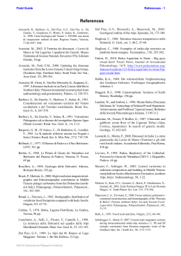
5
Rendiconti online Soc. Geol. It., Vol. 9 (2009), 5 -8
Relative sea-level rise and asymmetric subsidence in the
northern Adriatic
ANTONIOLI F.*, AMOROSI A’., CORREGGIARI A.’’, DOGLIONI C.° FONTANA A., FONTOLAN G.^, FURLANI
S.^ RUGGIERI °° SPADA G. °°
ABSTRACT
Variazioni relative del livello del mare e subsidenza differenziale sulle
coste settentrionali Adriatiche
Aim of this work is: i identify the genetic mechanisms of the
relative sea level rise along the N Adriatic coasts (vertical
movements), ii calculate the different contributions: eustatic,
isostatic (using the Selen model) and tectonic sensu Lambeck
et al. 2004 and isostatic, (using the Selen model) with the
scope to preview future scenarious on the coasts : at 2100 and
for the next millenia.
Key words: Relative sea level change, North Adriatic,
Tyrrhenian, Holocene
Our research is focused in the northern Adriatic, an area
densely populated, prone to a number of natural risks such as
seismicity, tsunami, subsidence in historical cities (e.g., Venice
and Ravenna) and sea-level rise. The comprehension of the
mechanisms governing these processes depends on the
accuracy of the available data. In this article we show how the
multidisciplinary approach reveals that the area is a prototype
for the overlap of a number of independent and interacting
geodynamic processes which control the relative sea-level and
the vertical movements of the lithosphere.
In order to calculate tectonic ratea, we use published and
new data observed along the north Adriatic coasts. Fiftheen
locations (cores) for the MIS 5.5 (15 ka) and hundred locations
(core or submerged archaeological sites) for the Holocene (last
10 ka cal BP).
Comparing the altitude observed in the core and the altitude
of sea during MIS 5.5 (7±2 m) and\or comparing the observed
Holocene markers with predicted sea level curves from Selen
model (Spada and Stocchi 2007), we obtained the tectonic
ratea.
The upper Pleistocene Tyrrhenian and Holocene sediments
of the northern Adriatic coast have been cored to measure their
depth. Both layers show an increasing depth moving from
_________________________
(*) ENEA, Dipartimento Ambiente, Casaccia, Roma
(‘) Earth Sciences Department, Bologna University
(“) ISMAR-CNR, Bologna
(°) Earth Sciences Department, Sapienza University, Roma
(°*) Department of Geography, Padova
(^) DiSGAM, Trieste University
(°°) Institute of Physics, Carlo Bo; Urbino University
northeast to southwest. Local deviations from this regional
trend occur along active anticlines. The northeastward
migration of the Apennines subduction hinge determines a
faster subsidence rate. These data support the dominant
influence of the Apennines subduction on the sea-level rise and
asymmetric subsidence in the northern Adriatic realm, an area
presently undergoing the combined effects of the Dinarides
and Alpine subduction as well.
As showed in fig. 1, the tectonic ratea (from MIS 5.5 core)
increase between -0.4 and -1 mm\yr moving from northeast to
southwest.
Tectonic data calculated from the Holocene cores are
generally in agreement with thoose of MIS 5.5. Archaeological
remains lying on rocky-substratum seem to be exellent as ea
level markers (Antonioli et al., 2007), on the contrary
sometimes Holocene data from cores show higher values,
reflecting, in this case, the anthropic or natural compaction.
Using theese different relative sea level data within the
recent prediction of eustatic and steric sea level acceleration
predicted for the next centuries (Roholing et al., 2009) we
provide maps of possible future flooding of the NE Adriatic
coasts.
The faster subsidence of the Pleistocene sediments,
including Holocene and Tyrrhenian, along the western side of
the northern Adriatic area confirms a link between these rates
and the SW-ward dip of the foreland regional monocline of the
Apennines, associated to the same subduction retreat. The
hinge of the northern Apennines slab is still moving toward the
NE, away from the upper plate, determining the subsidence in
the downgoing lithosphere that decreases moving toward the
foreland. The northern Adriatic lithosphere is also suffering the
effects of the subductions of the Alps and the Dinarides. The
asymmetry of the Pleistocene subsidence, however, indicates
that the Apennines have the most relevant role in shaping the
vertical rates in the northern Adriatic realm.
The coexistence of the three different mechanisms supports
a passive role of plate boundaries. The higher Holocene
tectonic subsidence with respect to the MIS 5.5 may be partly
attributed to sediment compaction, which does not contribute
to the long-term rate. East of Venice, Holocene lagoonal
sediments older than 6 ka show tectonic rates lower than 0.6
mm/a, similar to the long-term subsidence after an initial
compaction. Thus, -0.6 mm/a may be taken as the regional
subsidence rate in Venice area.
6
ANTONIOLI ET ALII
Fig.1 –. Map of the Northern Adriatic Sea with the distribution of the sites considered in the research. a) Alluvial and coastal sediments; b) pre-Quaternary bedrock;; d) isobath
line; e) inner margin of MIS 5.5 lagoon; f) most inner margin of Holocene lagoon; l) most landward position reached by the Holocene coast. Core with continental deposits during
MIS 5.5, A: Azzano, B: Faenza, C: Imola;
7
Relative sea-level rise and asymmetric subsidence in the northern Adriatic
REFERENCES
AMOROSI, A., COLALONGO, M.L., FIORINI, F., FUSCO, F.,
PASINI, G., VAIANI, S.C., SARTI, G., 2004. Palaeogeographic
and palaeoclimatic evolution of the Po Plain from 150- ky core
records. Global and Planetary Change 40, 55–78.
AMOROSI, A., FONTANA, A., ANTONIOLI, F., PRIMON, S.,
BONDESAN, A., 2008. Post-LGM sedimentation and Holocene
shoreline evolution in the NW Adriatic coastal area. GeoActa
7, 41–67.
ANTONIOLI, F., ANZIDEI, M., LAMBECK, K., AURIEMMA, R.,
GADDI, D., FURLANI, S., ORRU`, P., SOLINAS, E., GASPARI, A.,
KARINJA, S., KOVAC IC´ , V., SURACE, L., 2007. Sea level
change during Holocene from Sardinia and northeastern
Adriatic (Central Mediterranean sea) from archaeological and
geomorphological data. Quaternary Science Reviews 26,
2463–2486.
BRESSAN, G., SNIDARCIG, A. AND VENTURINI, C. (1998),
Present state of tectonic stress of the Friuli area (eastem
Southern Alps). Tectonophysics, 292, 211-227.
CARMINATI E., DOGLIONI C. & SCROCCA D. (2003), Apennines
subduction-related subsidence of Venice. Geophys. Res. Lett.
30, 13, 1717, doi:10.1029/2003GL017001.
CARMINATI E., DOGLIONI C. & SCROCCA D. (2005), Magnitude
and causes of long-term subsidence of the Po Plain and
Venetian region. Flooding and Environmental Challenges for
Venice and its Lagoon: State of Knowledge, ed. C. A. Fletcher
and T. Spencer with J. Da Mosto and P. Campostrini.
Cambridge University Press.
DI STEFANO, R., E. KISSLING, C. CHIARABBA, A. AMATO, AND
D. GIARDINI (2009), Shallow subduction beneath Italy: Threedimensional images of the Adriatic-European-Tyrrhenian
lithosphere system based on high-quality P wave arrival times,
J. Geophys. Res., 114, B05305, doi:10.1029/2008JB005641.
D'AGOSTINO N., D. CHELONI, S. MANTENUTO, G. SELVAGGI, A.
MICHELINI, AND ZULIANI, D. (2005), Interseismic strain
accumulation in the eastern Southern Alps (NE Italy) and
deformation at the eastern boundary of the Adria block
observed by CGPS measurements, Geophys. Res. Lett., 32,
L19306, doi:10.1029/2006GL024266.
DEVOTI C., RIGUZZI F., CUFFARO M. & DOGLIONI C. (2008),
New GPS constraints on the kinematics of the Apennines
subduction. Earth Planet. Sci. Lett., 273, 163–174.
DOGLIONI C. (1992), The Venetian Alps thrust belt. In: K.R.
McClay (Ed), Thrust Tectonics, Chapman & Hall, 319-324,
London.
DOGLIONI C. (1992), Relationships between Mesozoic
extensional tectonics, stratigraphy and Alpine inversion in the
Southern Alps. Eclogae Geologicae Helvetiae, 85, 1, 105-126.
DOGLIONI C. & CARMINATI E. (2002), The effects of four
subductions in NE Italy. Transalp Conference, Mem. Scienze
Geol., 54, 1-4.
DOGLIONI C., CARMINATI E., CUFFARO M. AND SCROCCA D.
(2007), Subduction kinematics and dynamic constraints. Earth
Science
Reviews,
83,
125-175,
doi:10.1016/j.earscirev.2007.04.001.
FERRANTI, L., ANTONIOLI, F., MAUZ, B., AMOROSI, A., DAI
PRA, G., MASTRONUZZI, G., MONACO, C., ORRU` , P.,
PAPPALARDO, M., RADTKE, U., RENDA, P., ROMANO, P.,
SANSO`, P., VERRUBBI, V., 2006. Markers of the last
interglacial sea level highstand along the coast of Italy:
tectonic implications. Quaternary International 145–146, 30–
54.
GALADINI, F., M.E. POLI, AND A. ZANFERRARI (2005),
Seismogenic sources potentially respon- sible for earthquakes
with M > 6 in the eastern Southern Alps (Thiene-Udine sector,
NE Italy), Geophys. J. Int., 160, 1-24, doi: 10.1111/j.1365246X.2005.02571.x.
LAMBECK K., ANZIDEI M., ANTONIOLI F., BENINI A, ESPOSITO
E., (2004) Sea level in Roman time in the Central
Mediterranean and implications for modern sea level rise.
Earth and Planetary Science Letter, 224 563-575.
LAMBECK K., ANTONIOLI F., PURCELL A. , SILENZI S., (2004)
Sea level change along the Italian coast for the past 10,000 yrs.
Quaternary Science Revue, 23, 1567-1598.
ROHLING E. J., K. GRANT, M. BOLSHAW, A. P. ROBERTS, M.
SIDDALL, CH. HEMLEBEN AND M. KUCERA (2009) Antarctic
temperature and global sea level closely coupled over the past
five
glacial
cycles.
Nature
Geosciences,
DOI:
10.1038/NGEO557
SLEJKO, D., NERI, G., OROZOVA, I., RENNER, G., WYSS, M.
(1999), Stress Field in Friuli (NE Italy) from fault plane
solutions of activity following the 1976 main shock. Bull.
Seismol. Soc. Am. 89, 4.
SPADA, G., STOCCHI, P., 2007. SELEN: a Fortran 90 program
for solving the “Sea Level Equation”. Computers and
Geosciences 33, 538. doi: 10.1016/j.cageo.2006.08.006.
SPADA, G., STOCCHI, P., COLLEONI, F., 2009a. Glacio-isostatic
adjustment in the Po plain and in the northern Adriatic region,
Pure and Applied Geophysics, doi:10.1007/s00024-004-04989
Rendiconti online Soc. Geol. It., Vol. 9 (2009) 8-11
Permo - Paleogene magmatism
in the Eastern Alps
BELLIENI G.(*), FIORETTI A.M.(**), MARZOLI A.(*) & VISONÀ D.(*)
Melting of crust and upper mantle is one of the main
geological processes that influences evolution of the
lithosphere. Magmatic products are strictly connected both to
the composition of their source region and to the geodynamic
context that triggers the magmatism. For this reason petrologic
investigations on igneous occurrences represent a powerful
tool to help trace the geodynamic evolution of those
lithospheric zones that were affected by magmatic activity.
Several magmatic events are recorded within the lithosphere of
the Eastern Alps spanning from Paleozoic to Cainozoic and
here we focus on the contribution of magmatic activity since
Permian times (Fig. 1).
Permo - Triassic Magmatism
The tectonic units of the Eastern Alps host a great variety
of intrusive and extrusive magmatic products ranging from
early Permian to Triasssic in age. Most of them (e.g.
Bressanone, Ivigna and Cima d’Asta: Fig. 1b) outcrop in the
Southern Alps. However, swarms of felsic Permian dikes
intrude the Austroalpine Unit, and since the late Devonian,
significant amounts of magma (e.g. Tuxer-Venediger,
Hochalm: Fig. 1a) and less known pegmatitic dikes (southern
Aurina Valley) also intruded the Pennidic and Southalpine
crust that is at present exposed in the Tauern windows. Despite
the effects of the Alpine metamorphic overprint, the age and
the geochemical and petrographic characters of the magmatism
in these metamorphic units have been ascertained.
Along an ideal north to south profile crossing the Eastern
Alps within the Italian territory, the Pennidic, Austroalpine and
Southalpine tectonic units follow one another. Two magmatic
phases of early Permian age characterize the Pennidic: the first
consists of intermediate to felsic (tonalite to granite) plutons
and lavas of calc-alkaline affinity that have been interpreted as
the results of a volcanic arc; the second, almost coeval,
consists of crustal-anatectic (granite) plutons (FINGER et alii,
1993, EICHHORN et alii, 2000)
The late Permian magma that intrudes the Austroalpine
_________________________
(*) Dipartimento di Geoscienze, Università di Padova, Via Matteotti n. 30,
35137 Padova
(**)CNR – IGG unità operativa di Padova, via Matteotti, 30, 35137 Padova,
Italy
crystalline basement as a swarm of granitic pegmatite dikes is
also of crustal anatectic origin (e.g. Southern Aurina Valley;
BORSI et alii, 1980). The small shoshonitic (mainly
monzodiorite to granite, with minor monzogabbro) pluton
cropping out at Eisenkappel (Austria) north of the contact with
Southalpine Unit is of middle Triassic age (LIPPOLT &
PIDGEON, 1974, VISONÀ & ZANFERRARI, 2000).
More abundant and complex was the magmatic activity
that, again in two distinct pulses (Lower Permian and middle
Trias), affected the Southalpine, a unit that was not
metamorphosed during the Alpine event. In this Unit the wide
tonalite to granite plutons (e.g. Bressanone, Cima d’Asta) with
smaller satellite gabbrodiorite bodies (e.g. Chiusa; VISONÀ et
alii, 1987) and the associated volcanic products of lower
Permian age (Athesian Volcanic District; BARTH et alii, 1993,
VISONÀ et alii 2007b) show a typical calc-alkaline affinity
suggesting that the magmatic activity was linked to a
collisional geodynamics (ROTTURA et alii, 1998).
The Triassic pulses consist mainly of monzonite and minor
nepheline syenite (e.g. Predazzo-Monzoni, BONADIMAN et alii,
1994; VISONÀ, 1997) and together with volcanic (Fernazza
formation, BARBIERI et alii, 1982, BRACK et alii, 2005)
products (Fig. 1b, d). They show geochemical and
petrographic characters ranging from high K2O calc-alkaline,
to typically shoshonitic, to alkaline affinity in the strict sense.
The geochemical characters of these magmas are consistent
with the extensional-transtensional tectonic setting recognized
in the Southalpine-Austroalpine and Dinaric domains during
the initial stages of Mesozoic rifting.
Paleogene magmatism
Starting from the early Cretaceous, a change in the plate
kinematics lead to the closure of the Tethys ocean and to the
continental collision of the African and European plates that
triggered the Alpine orogenesis. During the late phases of the
orogenesis (Eocene-Oligocene) significant magmatic activity
affected all the Alpine tectonic units along the whole chain.
Within the Eastern Alps, in the Austroalpine Unit, this
igneous activity is testified by calc-alkaline intermediate to
acidic intrusive bodies (with minor mafic occurrences) known
as the “Periadriatic plutons”. In the Southalpine, however, the
magmatic activity was typically extrusive to sub-volcanic and
shows a wide compositional spread encompassing alkaline to
Bellieni et alii.
tholeiitic geochemical compositions. The products of this
igneous activity constitute the “Veneto Volcanic Province”.
Periadriatic magmatism: magma emplacement within the
Austroalpine Unit was constrained by the existing tectonic
structures as shown by both the east-west alignment of the
Rensen, Vedrette di Ries (VdR), Cima di Vila (CdV), Monte
Alto, Polland and Eisenkappel plutons along the DefereggerAnterselva-Valles (DAV) tectonic lineament and by their
elongated forms (Fig. 1c).
The Periadriatic plutons show a sub-alkaline, calk-alkaline
affinity, and compositionally range from gabbro to
monzogranite, although intermediate granodiorite-tonalite
compositions prevail.
Rensen and VdR, both dated at around 31 Ma, show the
wider compositional range and share several geochemical and
petrologic characters. They are mostly composed of tonalite
and granodiorite with minor amounts of quartz-diorite (±
garnet) and granite. Except in granites, decimetric to
centimetric mafic microgranular enclaves (MME) are common
and their abundance and composition are strictly related to the
composition of the host rock. In the Rensen area, a small
gneissic granite body is confined to the north of the pluton.
For both Rensen and VdR plutons the geochemical
composition and isotopic data indicate that magmas were
generated by melting of deep crustal components with a
possible contribution from mantle-derived melts as suggested
by the presence of MME (BELLIENI et alii., 1989). The overall
variations in major and trace elements and Sr isotopic signature
of Rensen and VdR are broadly consistent with an evolution in
two subsequent stages of crystal/liquid fractionation. During
the first stage, at higher pressure, the fractionation of
hornblende+garnet produced various batches of liquid that,
while ascending through the crust, underwent a second, low
pressure stage of fractionation dominated by separation of
hornblende+plagioclase. In both cases crystal fractionation was
accompanied by interaction with crustal components
(assimilation and contamination by fluids).
The parent magmas of the VdR and Rensen suites were
both quartz- diorite/tonalite in composition but they show
slightly different chemical compositions likely reflecting minor
differences in the respective source material.
Granite from Rensen shows geochemical features that point
to an origin by melting of a pelitic source. The gneissic texture
indicates that it predates the emplacement of the main plutonic
mass (BELLIENI et alii., 1984, 1991).
Monte Alto and CdV plutons are quite homogenous. They
are mostly composed of granodiorite and contain only minor
MME. Geochemical and isotopic data obtained on Monte Alto
suggest that this rock type is the product of partial melting of a
deep crustal source followed by small degree of crystal/liquid
fractionation at lower pressure (BELLIENI et alii., 1984, 1996).
Geochemical and Sr isotopic signatures indicate that CdV is
not part of the nearby VdR pluton, but constitutes a genetically
unrelated body. Geochemical differences between the two
plutons may be explained by compositionally different magma
sources or by different degrees of partial melting of the same
9
source followed by significant modification of the Sr isotopic
ratio during emplacement, due to assimilation processes.
Granodiorite and tonalite porphyritic dikes genetically
related to the plutonic intrusions intrude the metamorphic
basement between Rensen and VdR, but do not crosscut the
plutons themselves.
Swarms of mafic dikes (both sub-alkaline and alkaline) that
cut both the plutons and their country rock represent the last
magmatic episode in the Austroalpine Unit and are similar to
coeval dikes related to partial melting of a mantle source
(BECCALUVA et alii., 1983).
Veneto Volcanic Province: this extensive igneous activity
(Fig. 1d) resulted from the tensional tectonic setting which
developed in the Southalpine foreland in response to the
Alpine collision (BECCALUVA et alii, 2007). The volcanic
activity lasted from late Cretaceous to late Oligocene, took
place during several magmatic pulses, and the resultant
volcanic products cover an area of more than 2000 Km2. The
volcanic activity was more intense in the eastern part of the
province (Mts. Lessini-Marostica) where alkaline mafic and
ultramafic rocks are found. The most representative rock types
in this area are basanite and alkali olivine basalt, followed by
nephelinite, transitional basalts, hawaiite, trachy-basalts and
basaltic andesite. These were produced in lava flows, pillow
lavas, volcaniclastic rocks, lava breccias and lava vents. In the
southernmost part of the Province (Euganean Hills)
subvolcanic bodies prevail and are of more felsic composition
indicating a clear polarity. The occurrence in these rocks of
frequent mantle xenoliths (spinel lherzolite, spinel harzburgite)
and zircon megacrysts (Visonà et al., 2007a) constitute a
unique opportunity to gain direct information on the nature of
the underlying lithospheric mantle.
REFERENCES
APAT (2004) – Geological map of Italy. Expecially printed for
the 32nd International Geological Congress. Firenze
(Italy)
BARBIERI, G., DE VECCHI, GP., DE ZANCHE, V., MIETTO, P. &
SEDEA, R. (1982) - Stratigrafia e petrologia del
magmatismo triassico nell’area di Recoaro. In:
CASTELLARIN, A. & VAI G.B., (eds.), Guida alla geologia
del Sudalpino centro-orientale. Soc. Geol. It. Guide
Geologiche Regionali, 179-187.
BARTH, S., OBERLI, F., MEIER, M., BLATTNER, P., BARGOSSI,
G.M. & DI BATTISTINI, G., (1993) - The evolution of a
calc-alkaline basic to silicic magma system: geochemical
and Rb–Sr, Sm–Nd, and O18 /O16 isotopic evidence from
the Late Hercynian Atesina– Cima d’Asta volcano–
plutonic complex, Northern Italy. Geochim. Cosmochim.
Acta 57, 4285– 4300.
BECCALUVA, L., BIGIOGGERO, B., CHIESA, S., COLOMBO, A.,
FANTI, G., GATTO, G.O., GREGNANIN, A., MONTRASIO, A.,
PICCIRILLO, E.M.. & TUNESI, A. (1983) - Post collisional
orogenic dyke magmatism in the Alps. Mem. Soc. Geol.
It., 26, 341-359.
10
Permo - Paleogene magmatism in the Eastern Alps
BECCALUVA, L., BIANCHINI, G., BONADIMAN, C., COLTORTI,
M., MILANI, L., SALVINI, L., SIENA, F. & TASSINARI, R.
(2007) - Intraplate lithospheric and sublithospheric
components in the Adriatic domain: Nephelinite to
tholeiite magma generation in the Paleogene Veneto
volcanic province, southern Alps, in BECCALUVA, L.,
BIANCHINI, G., AND WILSON, M., eds., Cenozoic
Volcanism in the Mediterranean Area: Geological Society
of America Special Paper 418, 131–152,
BELLIENI, G., PECCERILLO, A. & POLI G. (1981) - The Vedrette
di Ries (Rieserferner) Plutonic Complex: petrological and
geochemical data bearing on its genesis. Contrib. Mineral.
Petrol. 78, 145-156.
BELLIENI, G., PECCERILLO, A., POLI, G. & FIORETTI A.M.
(1984) - The genesis of Late Alpine plutonic bodies of
Rensen and Monte Alto (Eastern Alps): Inferences from
major and trace elements data. N.Jb. Miner. Abh., 149,
209-224.
BELLIENI G., CAVAZZINI G., FIORETTI A.M., PECCERILLO A.,
POLI G. & ZANTEDESCHI P. (1989) - Petrology and
geochemistry of microgranular mafic enclaves from
Vedrette di Ries plutonic complex (Eastern Alps). Per.
Mineral. 58, p. 45-65.
BELLIENI, G., CAVAZZINI, G., FIORETTI, A.M., PECCERILLO, A.
& POLI, G. (1991) - Geochemical and isotopic evidence
for crystal fractionation, AFC and crustal anatexis in the
genesis of the Rensen Plutonic Complex (Eastern Alps,
Italy). Chem. Geol. 92, 21-44.
BELLIENI, G., CAVAZZINI, G., FIORETTI, A.M., PECCERILLO, A.
& ZANTEDESCHI P. (1996) - The Cima di Vila (Zinsnock)
Intrusion, Eastern Alps: evidence for crustal melting,
acid-mafic magma mingling and wall rock fluid effects.
Mineralogy and Petrology 56, 125-146.
BONADIMAN, C., COLTORTI, M. & SIENA, F. (1994). Petrogenesis and T-fO2 estimates of Mt. Monzoni complex
(Central Dolomites, Southern Alps): a Triassic shoshonitic
intrusion in a transcurrent geodynamic setting. Eur J
Mineral 6 : 943±966
BORSI, S., DEL MORO, A., SASSI, F.P., VISONÀ, D. & ZIRPOLI,
G. (1980) - On the existence of Hercynian aplites and
pegmatites in the lower Aurina Valley (Ahrntal Austrides,
Eastern Alps). N. Jb. Mineral. Mh., 11: 501-514.
BRACK, P., RIEBER, H, NICORA, A. & MUNDIL R (2005) - The
global boundary Stratotype Section and Point (GSSP) of
the Ladinian Stage (Middle Triassic) at Bagolino
(Southern Alps, Northern Italy) and its implications for the
Triassic time scale. Episodes 28:233–244.
EICHHORN, R., LOTH, G., HÖLL, R., FINGER, F., SCHERMAIER,
A., & KENNEDY, A. (2000) - Multistage Variscan
magmatism in the central Tauern Window (Austria)
unveiled by U/Pb SHRIMP zircon data. Contrib. Mineral.
Petrol, 139, 418-435.
FINGER, F., FRASL, G., HAUNSCHMID, B., LETTNER, H., VON
QUADT, A., SCHINDLMAYR, A.O. & STEYER, H.P. (1993) The Zentralgneise of the Tauern Window (Eastern Alps):
insight into an intra-Alpine Variscan batholiths. In: VON
RAUMER, J.F. & NEUBAUER, F., (eds) Pre Mesozoic
geology in the Alps. Springer, Berlin Heidelberg New
York, 375-391.
LIPPOLT, H. . & PIDGEON, R., (1974) - Isotopic mineral ages of
a diorite from the Eisenkappel intrusion, Austria. Z
Naturforsch 29a, Wiesbaden.
MARROCCHINO, E., COLTORTI, M., VISONÀ, D. & THIRWALL,
M.F. (2002) - Petrology of Predazzo magmatic complex
(Trento, Italy). Geochim. Cosmoch. Acta , 66, 15A, Suppl
1, A486-A486
ROTTURA, A., BARGOSSI, G.,M., CAGGIANELLI, A., DEL MORO,
A., VISONA', D. & TRANNE, C.A. (1998) - Origin and
significance of the Permian high-K calc-alkaline
magmatism in the central-eastern Southern Alps, Italy.
Lithos 45: 329-348.
VISONÀ, D. (1997) - The Predazzo multipulse intrusive body
(Western Dolomites. Italy). Field and mineralogical
studies. Mem. di Sci. Geol., 49, 117-125.
VISONÀ, D., ALBERTI, F., STEFANI, C., & SCENICO, L. (1987) Le plutoniti di Chiusa, Dosso Lives e Luson. Una serie
calc-alcalina ercinica nelle Alpi Orientali. Mem. di Sci.
Geol. Padova, XXXIX, 85-99.
VISONA', D. & ZANFERRARI, A. (2000) - Some constraints on
geochemical features in the Triassic mantle of the
easternmost austroalpine-southalpine domain: evidence
from the Karawanken pluton (Carinthia, Austria). Int J
Earth Sci., 89: 40-51.
VISONÀ, D., CAIRONI, V., CARRARO, A., DALLAI, L., FIORETTI,
A.M. & FANNING, M. (2007a) - Zircon megacrysts from
basalts of the Venetian Volcanic Province (NE Italy): U–
Pb ages, oxygen isotopes and REE data. Lithos, 94, 168180.
VISONÀ, D., FIORETTI, A.M., POLI, E.M., ZANFERRARI, A. &
FANNING, M. (2007b) - U-Pb shrimp zircon dating of
andesites from Dolomite area (ne italy): geochronological
evidence for the beginning of the Permian volcanism in
EasternSouthalpine. Swiss Journal of Geosciences, 100,
313-324.
Bellieni et alii.
11
Fig. 1a – Upper Devonian to Permian magmatism in the Tawern window
(taken from FINGER et alii, 1993, modified).
Fig. 1 - Geological sketch map (taken from: Geological map of Italy, APAT
2004)
Fig. 1b – Permo – Triassic magmatism in the Southern Alps (taken from
ROTTURA et alii. 1998, modified).
Fig. 1c – Periadriatic magmatism in the Austroalpine Unit (taken from
BELLIENI et alii, 1989)
Fig. 1d – Triassic and Tertiary volcanic rocks (taken from BECCALUVA et alii,
2007, modified).
Rendiconti online Soc. Geol. It., Vol. 9 (2009), 12 -15
Indici e parametri fisici per il modello litostratigrafico del sottosuolo di
Venezia
JACOPO BOAGA (1), VITTORIO ILICETO (1) & FULVIO ZEZZA (2)
ABSTRACT
Indici e parametri fisici per il modello litostratigrafico del sottosuolo di
Venezia
Passive and controlled source seismic surveys were been accomplished in
the historical centre of Venice to characterized subsoil seismic indexes and
physical parameters. The techniques adopted allowed to enhance two main
different seismic responses for the venetian subsoil, in term of both elastic
earth parameters and seismic characteristics. In particular the HVSR
techniques applied reveal a relevant inhomogeneity due to the presence of
relatively strong acoustic impedance contrast in the first subsoil (8-10 meters
in depth).
The seismic surveys, supported by the geological reconstruction proposed,
were able to detect the presence of an alluvial complex identified as
'multistorey sandbody' furnishing physical parameters quantification for the
litho-stratigraphic model of the Venetian subsoil.
Key words: parametri sismici, Vs, Vp, prospezione sismica
passiva
LE TECNICHE DI INDAGINE
Al fine di fornire gli indici e i parametri fisici delle terre,
necessari alla definizione del modello lito-stratigrafico del
centro urbano di Venezia, si sono condotte tre tipologie di
indagini geofisiche volte alla caratterizzazione sismica dei
litotipi. Lo scopo della campagna di acquisizione era rivolto
sia alla determinazione del comportamento sismico dei terreni
della città di Venezia, sia alla caratterizzazione fisicomeccanica delle diverse litologie presenti. Per queste finalità
sono state condotte: i) indagini passive di rumore sismico
ambientale (microtremori), ii) prospezioni sismiche di sismica
a rifrazione in onda P, iii) prospezione sismiche attive di
sismica per lo studio della dispersione delle onde superficiali
(onda S).
LA SISMICA PASSIVA
La tecnica HVSR (Horizontal to Vertical Spectral Ratio,
HVSR o H/V) è applicata e sviluppata da più di 30 anni
(Nogoshi M., Igarashi T.1970), anche se deve la sua
diffusione a Nakamura (1989). Essa si basa sul rapporto
spettrale delle componenti orizzontali e verticali del moto del
suolo, dovuto al rumore sismico ambientale (microtremore).
___________________
1
2
già Dip. di Geoscienze, Università degli Studi di Padova
Dip. Costruzione dell'Architettura, Università IUAV di Venezia
Questa tecnica, nata principalmente per valutare
l'amplificazione sismica di sito (applicazione ampiamente
discussa e più volte confutata dalla comunità scientifica
internazionale), è in grado di determinare le frequenze
fondamentali di risonanza del sottosuolo, che corrispondono
ai picchi dei rapporti spettrali tra la componente verticale e le
componenti orizzontali del rumore sismico (Field e Jacob,
1993; Lachet e Bard, 1994, Lermo e Chavez-Garcia, 1993,
Ibs-von Shet e Wohlenberg, 1999). La natura dei picchi H/V
per opinione diffusa e convergente da parte della comunità
scientifica, è legata principalmente alla propagazione delle
onde di Rayleigh, non escludendo a priori, vista la
complessità del rumore sismico, importanti contributi di altri
tipi di onde (es. P ed SH).
In questo studio l'utilizzo del metodo HVSR è stato
finalizzato alla risonanza dei terreni, assumendo che il
fenomeno vibratorio sia legato alla propagazione di onde di
velocità prossima alle onde S che incidono su di un
semispazio semplificato, caratterizzato da un forte contrasto
di impedenza acustica. Con queste assunzioni si può
impiegare una funzione di trasferimento del tipo [1]. Un'onda
riflessa dalla superficie di contrasto interagisce con quelle
incidenti sommandosi e raggiungendo l'ampiezza massima
(condizione di risonanza) quando la lunghezza d'onda
incidente è 4 volte (o N multipli dispari) la profondità H del
rifrattore. Quindi imponendo la condizione di risonanza alla
[1], è possibile relazionare il periodo proprio di risonanza
osservato (Ts), lo spessore del sottosuolo sovrastante un
contrasto di impedenza acustica (H) e la velocità di taglio
(Vs) dello strato, tramite l'equazione [2].
F (ω) = 1/cos (ωH/Vs)
[1]
Ts = 2π/ω= 4H/Vs
[2]
Tale relazione è nota anche in molti altri campi che studiano
fenomeni ondulatori e condizioni di risonanza come ipotesi λ
/4.
Nel caso in cui il sottosuolo, come sovente accade,
sia costituito da una serie di strati con diverse impedenze
acustiche relative, la frequenza del picco principale o di
eventuali secondari, ammesso che essi non siano armoniche
superiori del principale, permette di riscontrare delle
disomogeneità nella risposta sismica che sono riferibili a
particolari contatti litologici.
Nel centro storico di Venezia sono state eseguite misure
tromografiche di rumore sismico con tromografi digitali a
Boaga J. Et ali
24bit, ad ampio range di frequenza (0.1-256 Hz). Le
acquisizioni sono avvenute secondo le indicazioni del progetto
SESAME (Europ. Seismo. Comm. 2004). Per ogni misura,
oltre allo spettro H/V, sono state condotte analisi temporali e
direzionali del segnale, al fine di determinare la continuità
temporale e spaziale del rumore, di fondamentale importanza
per una corretta interpretazione della misura.
Scopo delle indagini tromografiche è stata la verifica della
risposta acustica del complesso alluvionale del Pleistocene
superiore e, in particolare, quella della struttura sedimentaria
multistorey sandbody (F. Zezza, 2008) a prevalente
componente sabbiosa, rispetto alla successione a prevalente
componente argilloso-limosa che caratterizza i ciclotemi
ritmici dello stesso intervallo stratigrafico. La distribuzione dei
punti di misura ha tenuto conto delle sezioni litostratigrafiche
elaborate sulla scorta di 115 sondaggi superficiali (in F.
Zezza, 2008).
Le misure hanno interessato le seguenti ubicazioni: a) Piazzale
Roma, b) S.Basilio, c) Ss.Giovanni e Paolo, c) Stazione
S.Lucia, c) S.Barnaba, d) S.Samuele, e) S.Marco, f) Giardini
di S.Elena, g) S.Alvise, h) Sacca Fisola, i) Punta della Salute.
13
(0.1 -256 Hz). Per entrambe le tipologie di misura la sorgenti
sismica utilizzata è stato un fucile sismico industriale (cal.8).
Stendimenti di sismica a rifrazione in onda P (Vp), della
lunghezza rispettiva di 72 metri lineari, sono stati acquisiti
presso S.Basilio e presso i giardini reali di S.Marco. Per
l'interpretazione dei dati acquisiti si è adottata la comune
tecnica di elaborazione per lo studio delle onde rifratte.
Gli stendimenti, per lo studio delle velocità di
propagazione nel sottosulo dell'onda S (Vs), sono stati
condotti presso S.Basilio, presso S.Marco e presso Punta della
Salute. Gli stendimenti erano finalizzati allo studio della
dispersione delle onde supericiali. Il fenomeno dispersivo di
tali onde è di fatto legato alle Vs del mezzo attraversato, ed è
perciò possibile ricavare un modello di propagazione delle
onde di taglio in profondità. La tecnica di studio della
dispersione delle onde utilizzata è la metodologia FTAN
(Frequency Time Analysis in Panza 1981, Nunziata 2005).
Questa tecnica prevede di energizzare superficialmente il
suolo e di acquisire il segnale generato ad una certa distanza
con strumentazione di acquisizione molto sensibile (in grado
di acquisire basse frequenze). L'inter-distanza richiesta e la
frequenza dei ricevitori sono legati dalla profondità di
investigazione ricercata.
La stima della velocità delle onde S del sottosuolo
veneziano ha permesso la correlazione tra le frequenze
proprie del suolo valutate con le indagini di sismica passiva e
la profondità dei rifrattori sismici.
RISULTATI
Fig. 1 – Punti di acquisizione di rumore sismico e relativi rapporti
spettrali registrati
LE PROSPEZIONI SISMICHE ATTIVE
Al fine di caratterizzare le proprietà fisico-meccaniche dei
terreni sono stati condotti degli stendimenti sismici di tipo
attivo con sorgente sismica artificiale. Sono stati eseguiti sia
stendimenti di sismica a rifrazione in onda P che stendimenti
per lo studio della dispersione delle onde superficiali,
finalizzati alla valutazione delle velocità delle onde S.
Gli stendimenti di sismica a rifrazione hanno impiegato
stendimenti di 24 geofoni verticali (frequenza propria di 14.5
Hz) e un ricevitore con dinamica digitale a 24 bit. Gli
stendimenti per lo studio della dispersione delle onde
supericiali hanno utilizzato un unico ricevitore broad-band
Alla luce di quanto elaborato dalle indagini di sismica
passiva si riscontra come le misure presso S.Basilio,
S.Barnaba, Ss Giovanni e Paolo e P.le Roma, siano
significativamente diverse da quelle condotte presso gli altri
punti di misura. Si nota infatti, specialmente a P.le Roma e Ss
Giovanni e Paolo, l'esistenza di un solo forte picco a bassa
frequenza, dovuto ad un rifrattore molto profondo (vedi
eq.[2]).
I punti misura della Stazione, S.Alvise, S.Marco,
S.Samuele, Giardini, Sacca Fisola e Salute presentano invece,
oltre a picchi di bassa frequenza, un netto picco compreso tra
i 2.5 e i 3.5 Hz, riconducibile ad una disomogeneità acustica
presente nel primo sottosuolo.
Le misure di S.Basilio e S.Barnaba presentano un blando
picco a 2.5Hz, l' analisi delle singole componenti e l'analisi
direzionale dimostra come si tratti di una risposta molto
debole. Tali spettri rappresentano dunque una condizione
intermedia tra i 2 casi esposti precedentemente.
Per stimare la profondità del rifrattore sismico con la
tecnica HVSR si è ricorsi ai valori di Vs dei sedimenti che
sovrastano il corpo sabbioso alluvionale 'multistorey
sandbody '. Si tratta di terreni di riporto composti da limi,
argille, torbe e argille con resti di molluschi.
Dalle analisi di sismica attiva effettuate presso la Salute, si
riscontra come i primi 7 metri di sottosuolo siano
14
Indici e parametri fisici per il modello litostratigrafico del sottosuolo di Venezia
caratterizzati da una velocità delle onde di taglio (Vs) molto
bassa, prossima ai 110m/s, propria di terreni coesivi ad alta
plasticità. Il risultato appare in accordo con la natura litologica
e con le caratteristiche geotecniche delle terre investigate. Al
di sotto questi materiali le velocità S difatti aumentano
bruscamente sino a 280 m/s, velocità riconducibile a depositi
sabbiosi. Anche le prospezioni a rifrazione in onda P (che
hanno sofferto del rumore ambientale), individuano 2
Zezza, 2008). I risultati, infatti, evidenziano il forte contrasto
di impedenza acustica rappresentato dalle sabbie di canale
alluvionale, ben rilevabile dalle indagini tromografiche.
Spostandosi lateralmente da tale multistrato sabbioso, la
Tab. 1 –Tabella dei valori di velocità per i diversi sismostrati identificati
sismostrati, rispettivamente di 350 m/s e 940 m/s.
Le misure sismiche attive condotte presso S.Basilio
indicano un sottosuolo molto diverso dalle condizioni di
S.Marco/Salute. Al di sotto degli 8 metri di profondità difatti
le velocità S persistono su valori molto bassi, tipici di
sedimenti coesivi plastici. La differenza tra il corpo
sedimentario multistrato sabbioso e le alternanze ciclotemiche
è dunque rilevante. Anche in questo caso la prospezione in
onda P individua 2 sismostrati, aventi velocità rispettivamente
di 300m/s e 750m/s, confermando la natura differente dei
sedimenti rispetto alla zona S.Marco/Salute. La differente
velocità delle onde di taglio tra i 2 siti è da ritenersi più
rappresentativa, essendo dovute alla sola matrice solida dei
sedimenti; le velocità delle onde compressionali (P) difatti non
differiscono sensibilmente, risentendo della presenza di corpi
acquiferi. Abbinando i dati degli stendimenti sismici attivi alla
sismica passiva tramite l'equazione [2], si relaziona lo spessore
del sismostrato al di sopra di un contrasto di impedenza, le Vs
e la frequenza propria di risonanza. In tal modo si ottiene una
stima della profondità del rifrattore responsabile del picco in
frequenza tra i 2 e i 3.5 Hz. Le frequenze interessate dai
picchi H/V variano al variare della profondità del rifrattore,
difatti l'approfondirsi dell’orizzonte sabbioso (es. Sacca
Fisola) determina uno shifting del picco H/V verso le basse
frequenze (3Hz), al contrario, un innalzamento dell'orizzonte
sabbioso (S.Marco) determina un picco a 3.5Hz. Le profondità
stimate, comprese tra 7.5 e 13 metri dal piano campagna,
appaiono in buon accordo con la distribuzione delle sabbie di
canale alluvionale delle incisioni attribuibili alla fase
regressiva coincidente con l’ultimo massimo glaciale (F.
Fig. 2 – Vs, frequenza propria e profondità stimata del rifrattore per i punti di
indagine
risposta acustica delle sabbie in seno ai sedimenti argillosolimosi con torba della successione ciclotemica del Pleistocene
Superiore (facies delle fasi interstadiali) appare molto debole
a motivo della consistente diminuzione di spessore delle
sabbie stesse (m 1.8-2.50), come si registra, ad esempio,
presso S.Basilio e S.Barnaba. Dove, infine, la risposta
dell'analisi H/V non presenta nel primo sottosuolo picchi
riconducibili alla presenza di sabbie (P.le Roma, Ss. Giovanni
e Paolo), il contrasto è assente e avvalora le relative
ricostruzioni litostratigrafiche del centro storico (F. Zezza,
2008).
La Fig. 3 indica i punti di misura e le descritte risposte di
risonanza in relazione alla ricostruzione paleogeografica
dell’area del centro storico di Venezia durante l'ultima
regressione Wurmiana.
La misura dei proprietà fisico-meccaniche delle terre, quali i
valori di velocità sismica dell'onda compressionale e
trasversale, avvalorano la ricostruzione dei differenti domini
sedimentari e forniscono un primo supporto di
parametrizzazione per la modellazione litostratigrafica del
sottosuolo del centro storico di Venezia.
Boaga J. Et ali
15
NOGOSHI M., IGARASHI T. (1970): On the propagation
charactestics of the microtremors. J. Seism. Soc. Japan 24, pp. 2440.
NUNZIATA C. (2005): FTAN method for detailed shallow VS
profiles, Geologia Tecnica e Ambientale, 3, 51-69
PANZA G.F. (1981): The resolving power of seismic surface waves
with respect to the crust and upper mantle structural models. In
Cassinis R. Ed. The solution of the inverse problem in geophysical
interpretation, Plenum Publishing Corporation 39-77
FIELD E.H., JACOB, K., (1993): The theoretical response of
sedimentary layers to ambient seismic noise. Geophys. Res. Lett.,
20Ð24, 2925Ð2928.
Fig. 3°- Ricostruzione paleogeografica del canale alluvionale sabbioso
dell'ultima regressione wurmiana (F.Zezza 2008).
IBS-VON SEHT M. e WOHLENBERG J.,(1999): Microtremor
measurements used to map thickness of soft sediments.Bull.
Seismol. Soc. America, 89,
250-259.
LACHET C, BARD P.-Y. (1994): Numerical and Theoretical
investigations on the possibilities and limitations of Nakamura's
Technique. J. Phys. Earth 42,
pp. 377-397.
LERMO J., CHAVEZ-GARCIA F.J., (1993): Site effect evaluation
using spectral ratios with only one station, Bull. Seismol. Soc. Am.,
83, 1574 - 1594.
ILICETO V, BOAGA J. (2005): Deterministic approach and seismic
noise measurements for seismic site effect estimation in Adige
Valley (North Italy). Geologia Tecnica e Ambientale, 4/2005
Fig. 3b - In giallo i punti di misura di prospezione sismica passiva che hanno
riscontrato la presenza della struttura sedimentaria (multistorey sandbody), in
verde i punti dove tale rifrattore non è presente (cyclothemic organization).
LAVORI CITATI
NAKAMURA Y. (1989): A method for dynamic characteristics
estimation of subsurface using microtremors on the ground surface.
Quaterly Rept. RTRI, Japan 33, pp. 25-33.
ILICETO V. BOAGA J (2006): Valutazione delle Vs30 in terreni
lagunari mediante il Metodo FTAN (Frequency-Time Analysis). Atti
del workshop Geofisica e tecniche di indagini non invasive applicate
agli ambienti estremi. Rovereto 1-12-200
ZEZZA F., (2007) - Geologia, proprietà e deformazione dei terreni
del
centro storico di Venezia. In “Geologia e Progettazione nel centro
storicodi Venezia”, II Convegno Nazionale La Riqualificazione delle
città e deiterritori, Venezia 7 dicembre 2007, Quad IUAV 54, Il
Poligrafo Ed., 2008, 9-41
Rendiconti online Soc. Geol. It., Vol.9 (2009), 16-17
Geology and evolution of the N Adriatic structural triangle between
Alps and Apennines
ALBERTO CASTELLARIN (*)
Geologia ed evoluzione del triangolo strutturale alto adriatico tra Alpi e
Appennini
The basic kinematic evolution leading to the present
tectonic setting of the Northern Adriatic zone are here
synthetically outlined. The Adriatic domain is the structural
area progressively invaded by neighbouring orogenic chains.
From the E the Dinaric structural system incorporated a wide
sector of the Adria microplate during late Cretaceous and
mostly Paleogene times.
Fig. 1 – TAP: Seismic line of the Transalp project (Transalp Working Group,
2001).
To the N the Miocene and Plio-Pleistocene compressions
originated the thrust belt of the Southern Alps and the out of
sequence thrust structures inside the Penninic and Austroalpine
nappes of the Eastern Alps. Here the deep and huge
indentation to the N of the Adriatic lithosphere underneath the
Tauern window is documented by the seismic reflection results
of the Transalp Project. Such an indentation may be considered
the leading engine for the progression to the S of the Sothern
Alp thrust belt.
Fig. 3 – Scheme of the rotational kinematics in the northern Mediterranean
area.
Along the Adriatic western border, the MessinianPleistocene tectonic transport of the orogenic frontal zones of
the Apennines invaded the Adriatic domain incorporating a
large extent of the south western side of Po-plain area which
was largely incorporated inside the frontal thrust belt of the
northern Apennines. Severe restriction of the Adriatic space
resulted by these processes. The transport of the Apennine
orogenic wedge over the Adria continental margin may range
from some to several hundred km according to the different
_________________________
(*) Dipartimento di Scienze della Terra e Geologico-Ambientali, Università
di
Bologna,
via
Zamboni
67,
40126
Bologna.
e-mail:
[email protected]
Fig. 2 – Section across the Dolomites predating the Transalp Profile.
ALBERTO CASTELLARIN
Apennine interpretations. Consequently the present Adria
marine domain corresponds to a reduced foreland-foredeep
area nearly consumed by the orogenic evolution occurred
along its borders. Thick Pliocene –Pleistocene foredeep
deposits follow the progression of the migration to the N and
NE of the Apennines frontal thrust belt . The facing foredeep
deposition in the opposite frontal Southern Alps thrust belt
largely developed during Neogene and stopped in late
Messinian time. As documented by stratigraphic and structural
data, as the matter of facts, here, the compression deformations
strongly acted also during the Pliocene and Pleistocene times.
Up to the present times!. As indicated by the strong seismicity
potential of historical and recent earthquakes of the Friuli and
Carnic zones.
17
BASIC REFERENCES
CASTELLARIN A., CANTELLI L., FESCE A.M., MERCIER J.L.,
PICOTTI V., PINI G.A., PROSSER G. & SELLI L. (1992) Alpine compressional tectonics in Southern Alps.
Relationships with the N-Apennines. Annales Tectonicae, 6
(1), 62-94.
TRANSALP WORKING GROUP (INCLUDING A.CASTELLARIN)
(2001) - European Orogenic Processes Research Transect
the Eastern Alps. EOS, Transaction, American Geophysical
Union., 82 (40), 453-461.
GEBRANDE H., CASTELLARIN A., LÜSCHEN E., MILLAHN K.,
NEUBAUER F., NICOLICH R., (Editors). (2006)
TRANSALP—A transect through a young collisional
orogen. Tectonophysics 414, 1-281pp.
Rendiconti online Soc. Geol. It., Vol. 9 (2009), 18-20
Processi petrogenetici nella crosta medio-profonda delle Alpi
Orientali
BERNARDO CESARE (*), CLAUDIO MAZZOLI (*), RAFFAELE SASSI (*), RICHARD SPIESS (*) & FRANCESCO P. SASSI
(*)
ABSTRACT
Per la sua complessa storia geologica che comprende eventi magmatici e
metamorfici avvenuti nel Caledoniano, Ercinico e Alpino, in contesti variabili
di pressione, temperatura e deformazione, il basamento cristallino delle Alpi
Orientali costituisce da quasi un secolo la “palestra” per le ricerche
petrologiche di numerosi ricercatori.
Questo Review Paper descrive gli aspetti più caratteristici inerenti alla
petrogenesi metamorfica, con particolare interesse per le metapeliti.
Key words: Alpi Orientali, Austroalpino, crosta medioprofonda, metamorfismo, metapeliti, petrogenesi.
INTRODUCTION
This Review Paper deals with the main aspects and with the
most peculiar characteristics of the petrogenetic processes that
developed in the rocks of the crystalline basement of the
Eastern Alps that were once located at medium- to deep-crustal
conditions. The crystalline basement of the Eastern Alps,
traditional field area of geologists from the University of Padua
since the pioneering works of Angelo Bianchi and
Giambattista Dal Piaz, was the area of widespread fieldwork
(and related geological and petrographic research) in the 60's
and 70's, and finally has received renewed attention in the last
two decades, especially from the point of view of metamorphic
petrology. This region, situated in close proximity to the
collision zone between the southern Adriatic microplate and
the northern European plate, is characterized by:
- prolonged and complex metamorphic and magmatic
evolution recording pre-Variscan, Variscan and multiple
Alpine events;
- highly variable and heterogeneous lithological
composition, resulting from such complex geodynamic
evolution;
- highly various and heterogeneous deformation history,
related to the heterogeneous involvement of rock units in the
polyphase deformational and heating events, which were
particularly significant during Alpine collision.
Owing to the above features, accompanied by the presence
of an important late-Alpine intrusion (the Vedrette di Ries Rieserferner pluton), the Eastern Alps represent a well suited
natural laboratory for the study of petrogenetic processes in
rocks showing a wide range of compositions, pressure-
temperature-time histories, degrees of deformation. The
different rock units in the region provide an aggregate vision of
how the Earth's crust may behave during a complex evolution
including collision, rifting, subduction, renewed collision and
final exhumation, and of how polydeformed and
polymetamorphic old basement rocks are variously reworked
during later events.
The geochronological framework of magmatic and
metamorphic events, and the lithostratigraphy of the crystalline
basement have been recently reviewed by SCHULZ et alii
(2008), whereas the details of the magmatic activity, from
Permian to Cenozoic, and the geodynamic evolution of the
region are presented in two companion papers (respectively
BELLIENI et alii and SPIESS et alii, this volume). Therefore we
can focus on some case studies related to the main petrogenetic
processes that have been observed, studied and modelled in
these rocks, with emphasis on metamorphism in several of its
aspects such as kinetics, deformation/crystallization
relationships, fluid-rock interactions and thermobarometry.
Our perspective is phenomenological in the sense that we
discuss several processes for their petrological importance and
applicability to other contexts, rather than for their local
interest. Most of the processes described here are relevant to
metapelites, the most abundant rock types in the basement of
the Eastern Alps.
KINETICS OF METAMORPHIC REACTIONS
The kinetic aspects of nucleation and growth of minerals in
metapelites are of particular interest when garnet or the
Al2SiO5 polymorphs are concerned. In some cases, garnet
porphyroblasts can be the product of a complex process of
multiple nucleation (with clusters of many nuclei rather than
single, isolated crystals), coalescence, and rotation of single
grains. The rotation is driven by minimization of
crystallographic misorientation, as modelled by SPIESS et alii
(2001) and DOBBS et alii (2003).
Studying the pyrometamorphic crustal xenoliths in the volcanic
rocks from the Euganean Hills, SASSI et alii (2004a) have
contributed to a better understanding of the "fibrolite problem",
i.e., of the relative stabilities of the acicular versus coarse
variety of sillimanite. The acicular fibrolite may grow at hightemperature metamorphic conditions because of its anisotropic
surface energy when reaction boundaries are significantly
overstepped.
P. AUTORE ET ALII
(STILE: INTEST. PAGINE PARI)
Still with Al2SiO5 polymorphs, epitaxy – the growth of one
crystal under the crystallographic control of the structure of
another – has been observed in the replacement of staurolite by
kyanite (CESARE and GROBETY, 1995) in rocks that, owing to
their complex polymetamorphic history, have developed
unique nodular textures pseudomorphing primary garnet and
composed in turn by fibrolite, kyanite, staurolite and muscovite
(CESARE, 1999).
19
Anatexis may also have affected the thickened continental
crust after Alpine collision. Although there is no outcropping
evidence of Alpine migmatites, the geochemical composition
of some leucogranitic dikes around the Vedrette di Ries pluton
is compatible with an origin by crustal anatexis (CESCUTTI et
alii, 2003).
CONTACT METAMORPHISM
THERMOBAROMETRY
High-pressure metamorphism, marked by the occurrence of
eclogites, is recorded both in Variscan and Alpine time.
Concerning Alpine eclogites, they occur in the western
(SPIESS, 1991) and eastern (SASSI et alii, 2004b) sectors of the
Austroalpine basement, as well as in the eastern Penninic
Tauern Window (SPEAR and FRANZ, 1986). Here the rocks
were buried at pressure approaching 20 kbar. Increasing
pressure was also recorded in metapelites by specific
microstructures (Mazzoli et alii, 2001).
High-temperature metamorphism and crustal melting in the
Austroalpine domain occurred in the Permian at ca. 650-680
°C and 6-8 kbar (STÖCKERT, 1985; MORETTI; 2001), whereas
LP-LT conditions pressure are recorded in the numerous
phyllitic complexes (SASSI & SPIESS, 1992). During the Alpine,
these rocks were moderately involved in the clockwise P-T
evolution accompanying collision and erosion, and record
greenschist-facies conditions of 450 ± 50 °C and, at least in its
eastern part, 7.5 ± 1.5 kbar.
The contact aureole formed by the emplacement of the
Oligocene Vedrette di Ries pluton not only represents an
excellent natural petrological laboratory, but has also allowed
some constraints on the late-Alpine evolution of this part of the
Austroalpine basement to be placed. The pressure of
emplacement of the pluton can be tightly constrained due to the
presence of the characteristic assemblage quartz-muscovitebiotite-andalusite-staurolite: the recent calculation of
TAJCMANOVA et alii (2009) provide a pressure of 4.1 ± 0.1
kbar, corresponding to c. 15 km depth. This value makes
Vedrette di Ries a "deep" pluton, when compared with the
other Periatriatic intrusions. From such depth of emplacement
an average exhumation rate of 0.5 mm/yr can be calculated. In
addition, since the diagnostic assemblage andalusite-staurolite
can be found further to the west (MORETTI and MAZZOLI,
2000) for an overall distance of > 30 km, post-Oligocene E-W
tilting or vertical extrusion cannot be responsible for more than
3 km differential denudation.
REFERENCES
FLUID-ROCK INTERACTIONS
Fluid-rock interactions during metamorphism have been
characterized at variable lengthscales and with variable
relationships to deformation. Near the Austroalpine-Penninic
suture, where the degree of Alpine syncollisional shear
deformation is maximum, the phyllonites of Cima Dura have
been interpreted as km-sized preferential zones of channellized
fluid flow and associated retrograde alteration (MAZZOLI et
alii, 1993).
On a much smaller scale, quartz-rich veins bearing andalusite
(CESARE, 1994) or biotite and plagioclase (CESARE et alii,
2001) represent the product of rock hydrofracturing during
devolatilization reactions in a static environment. The fluids
analysed in the fluid inclusions from these synmetamorphic
veins are compatible with an internal origin and with the
inferred P-T conditions of reaction (CESARE and HOLLISTER,
1995).
CRUSTAL MELTING
An important event of crustal melting affected the Austroalpine
basement during the Permian, producing metapelitic
migmatites intruded by widespread pegmatites (BORSI et alii,
1980). The characterization by Raman spectroscopy of
inclusions in garnet indicates that anatexis occurred in the
stability field of sillimanite, later transformed into kyanite.
BELLIENI G., MARZOLI A. & VISONÀ D. (2009) - Magmatismo
permo-cenozoico subalpino. (This volume)
BORSI S., DEL MORO A., SASSI F.P. & ZIRPOLI G. (1979) - On
the age of the Vedrette di Ries (Rieserferner) massif and
its geodynamic significance. Geol. Rdsch., 68, 41-60.
CESARE B. (1994) - Synmetamorphic veining: origin of
andalusite-bearing veins in the Vedrette di Ries contact
aureole, Eastern Alps, Italy. J. Metamorphic Geol., 12,
643-653.
CESARE B. & GROBETY B. (1995) - Epitaxial replacement of
kyanite by staurolite: a TEM study of the microstructures.
Am. Mineral., 95, 78-86.
CESARE B. & HOLLISTER L.S. (1995) - Andalusite-bearing
veins at Vedrette di Ries (Eastern Alps - Italy): fluid phase
composition based on fluid inclusions. J. Metamorphic
Geol., 13, 687-700.
CESARE B. (1999) - Multi-Stage pseudomorphic replacement
of garnet during polymetamorphism: Microstructures and
their interpretation. J. Metamorphic Geol., 17, 723-734.
CESCUTTI C., FIORETTI A.M., BELLIENI G. & CESARE B. (2003)
- Studio petrografico e geochimico dei filoni porfirici acidi
affioranti nel basamento austroalpino nei dintorni di
Vedrette di Ries (Alto Adige Orientale). GeoItalia 2003
Congress, Abstract p. 201.
CESARE B., POLETTI E., BOIRON M-C. & CATHELINEAU M.
(2001) - Alpine metamorphism and veining in the
Zentralgneis Complex of the SW Tauern Window: a model
20
TITOLO DEL LAVORO (STILE: INTEST. DISPARI)
of fluid-rock interactions based on fluid inclusions.
Tectonophysics, 336, 121-136.
DOBBS H.T., PERUZZO L., SENO F., SPIESS R. & PRIOR D.J.
(2003) - Unravelling the Schneeberg garnet puzzle: a
numerical model of multiple nucleation and coalescence.
Contrib. Mineral. Petrol., 146, 1-9.
MAZZOLI C., PERUZZO L. & SASSI R. (1993) - An Austroalpine
mylonite complex at the southern boundary of the Tauern
Wiindow: crystallizzation-deformation relationships in the
Cima-Durreck Complex. IGCP No 276, Field Meeting,
Abstracts, 30-35.
MAZZOLI C., SASSI R. & BARONNET A. (2001) - A peculiar MsPg textural association in a chloritoid-bearing micaschist
recording a multistage P-T path. Eur. J. Mineral., 13,
1127-1138.
MORETTI A. (2001) - Polymetamorphic evolution of the
metapelites from the Pusteria valley (Austroalpine
basement, Eastern Alps): micro-textures modeling.
Plinius, 25, 70-74.
MORETTI A. & MAZZOLI C. (2000) - Record of a buried
igneous body underneath the Mt. Mutta area (Eastern
Alps). Plinius, Abstracts, 24, 155-156.
SASSI R. & SPIESS R. (1992) - Further data on the pre-Alpine
metamorphic pressure conditions of the Austridic phyllitic
complexes in the Eastern Alps. IGCP No. 276, Newsletter,
5, 297-307.
SASSI R., MAZZOLI C., SPIESS R. & CESTER T. (2004a) Towards a better understanding of the fibrolite problem:
the effect of reaction overstepping and surface energy
anisotropy. J. Petrol., 45, 1467-1479.
SASSI, R., MAZZOLI, C., MILLER, CH. & KONZETT, J. (2004b) -
Geochemistry and metamorphic evolution of the Pohorje
Mountain eclogites from the easternmost Austroalpine
basement of the Eastern Alps (northern Slovenia). Lithos
78, 235-261.
SCHULZ B., STEENKEN A. & SIEGESMUND S. (2008) Geodynamic evolution of an Alpine terrane the
Austroalpine basement to the south of the Tauern Window
as a part of the Adriatic Plate (eastern Alps). Tectonic
Aspects of the Alpine-Dinaride-Carpathian System.
Geological Society, London, Special Publications, 298, 5–
44.
SPEAR F.S. & FRANZ G., (1986) - P-T evolution of
metasediments from the Eclogite zone, south-central
Tauern Window, Austria. Lithos, 19, 219-234.
SPIESS R. (1991) - High-pressure alteration of eclogites from
the Austroalpine basement north of Merano-Meran
(Eastern Alps). Eur. J. Mineral., 3, 895-898.
SPIESS R., PERUZZO L., PRIOR D.J. & WHEELER J. (2001) Development of garnet porphyroblasts coalescence and
boundary misorientation driven rotation. J. Metamorphic
Geol., 19, 269-290.
SPIESS R., CESARE B., MAZZOLI C., SASSI R. & SASSI F.P.
(2009) - Il basamento cristallino della placca adriatica
(This volume).
STÖCKHERT B. (1985) - Pre-Alpine history of the Austridic
basement to the south of the western Tauern Window
(Southern Tyrol, Italy). Caledonian versus Hercynian
event. Neu. Jb. Geol. Paläont. Mh., 10, 618-642.
TAJCMANOVÁ L., CONNOLLY J.A.D. & CESARE B. (2009) - A
thermodynamic model for titanium and ferric iron solution
in biotite. J. Metamorphic Geol., 27, 153-165.
Rendiconti online Soc. Geol. It., Vol. 9 (2009) 21-24
Present geodynamics of the northern Adriatic plate
MARCO CUFFARO*, CARLO DOGLIONI*,° & FEDERICA RIGUZZI^
ABSTRACT
The northern Adriatic plate is surrounded and squeezed by three orogens
(i.e. Apennines, Alps and Dinarides). Therefore, in the same area, the effects of
three independent subduction zones coexist and overlap. This supports the
evidence that plate boundaries are passive features.
The northeastward migration of the Apennines subduction hinge
determines the present-day faster subsidence rate in the western side of the
northern Adriatic (>1 mm/yr). This is recorded also by the dip of the foreland
regional monocline, and the increase SW-ward of the depth of the Tyrrhenian
layer, as well as the increase in thickness of the Pliocene and Pleistocene
sediments. These data indicate the dominant influence of the Apennines
subduction and the related asymmetric subsidence in the northern Adriatic
realm. The Dinarides front has been subsided by the Apennines subduction
hinge, as shown by the eroded Dalmatian anticlines in the eastern Adriatic Sea.
GPS data show the horizontal pattern of motion along the front of the three
belts surrounding the northern Adriatic plate. Values of shortening along the
prisms are in the order of 2-3 mm/yr (Northern Apennines), 1-2 mm/yr
(Southern Alps) and <1mm/yr (Dinarides). The pattern of the new GPS
velocities relative to Eurasia account for different tectonic domains and the
estimated strain rates are within 0.1 μstrain/yr. The shortening directions tend
to be perpendicular to the thrust belt fronts, as expected. The areas where the
strain rate sharply decreases across a tectonic feature (e.g., the Ferrara salient)
are considered structures seismically loading the brittle layer.
Key words: Adriatic plate, Plate boundaries, thrust tectonics,
subsidence, strain rate
GPS DATA AND STRAIN RATE
The largest GPS time span covers an interval of 11 years
(1998–2008), nevertheless most of the data come from the
recent RING network (http://ring.gm.ingv.it) settled in Italy in
the last five years by INGV. The GPS data processing follows
basically the procedure proposed in DEVOTI et alii (2008).
We have analyzed the GPS observations at 30 s sampling
rates in the framework of the processing of all the Italian
_________________________
* Dipartimento di Scienze della Terra, Università Sapienza, Roma
° Istituto di Geologia Ambientale e Geoingegneria, CNR, Roma
^ Istituto Nazionale di Geofisica e Vulcanologia, Roma
Research supported by Topoeurope, Topo-4D project, CNR.
Fig. 1 – GPS velocities relative to Eurasia and the rescaled error ellipses, in
the northern Adriatic realm, where three subduction zones interacts
(Apennines, Alps and Dinarides). Velocities are divided in three clusters
(red cluster 1, blue cluster 2, and gray cluster 3) to estimate local strain
rates.
permanent stations. We have processed the data with the
Bernese Processing Engine (BPE) of the Bernese software,
version 5.0 (BEUTLER et alii, 2007) based on the double
difference observables. We have estimated each daily cluster in
a loosely constrained reference frame, imposing a priori
uncertainties of 10 m to obtain the so–called loosely
constrained solution. The daily loosely constrained cluster
solutions are then merged into global daily loosely constrained
solutions of the whole network applying the classical least
squares approach (DEVOTI et alii, 2008). The daily combined
network solutions are then rigidly transformed into the
ITRF2005 frame (ALTAMIMI et alii 2007), estimating
translations and scale parameters.
The velocity field is estimated from the ITRF2005 time
series of the daily coordinates, with the complete covariance
matrix, simultaneously estimating site velocities, annual signals
and offsets at epochs of instrumental changes, as in DEVOTI
et alii (2008) and in RIGUZZI et alii (2009).
We have scaled the formal errors of the GPS rates using
the mean scale factors estimated for each velocity component,
as in DEVOTI et alii (2008), according to the approach
developed in WILLIAMS (2003).
22
CUFFARO ET ALII
The GPS site positions and velocities with respect to the
Eurasian fixed reference frame, as defined in DEVOTI et alii
(2008), with their re-scaled uncertainties are reported in Fig. 1.
We estimate the strain rate field solving the two–
dimensional velocity gradient tensor equations, with an inverse
procedure, based on the standard least squares approach. The
GPS velocities are separated in 3 clusters, accounting for the
main tectonic domains (Fig. 1). We use a regularly spaced
gridded interpolation method, based on the distance weighted
approach (SHEN et alii, 1996; ALLMENDINGER et alii, 2007;
CARDOZO & ALLMENDINGER, 2009). We define a regular grid
(30´30 km) estimating the strain rate principal axes at the
center of each cell, using all the GPS velocities pertaining to
each cluster. The velocity of each station is weighted by the
factor W = exp( − d 2 / 2α 2 ) , where d is the distance between
each GPS site and the center of the cell, and a (22 km) is the
damping parameter defining how the contribute of each station
decays with distance from the cell center.
The pattern of the strain rate principal axes (Fig. 2) shows
that most of shortening directions tend to be perpendicular to
the thrust belt fronts, reaching 82±11 nstrain/yr in cluster 1
(Eastern Veneto, Friuli, Southern Austria), 44±8 nstrain/yr in
cluster 2 (Western Veneto, Lombardy, Emilia-Romagna) and
with lower values offshore, in cluster 3 (Marche), where the
GPS velocities are not able to constrain with good accuracy the
deformation rate. The extension rate axes reach the maximum
value of 45±19 nstrain/yr in cluster 1; minor rates are 35±15
nstrain/yr in cluster 2 and 56±18 nstrain/yr in cluster 3.
Fig. 2 – Principal axes of strain rates from GPS velocities in the northern
Adriatic area estimated on a regularly spaced grid (30´30 km). Black and
white arrows represent shortening and extension rate principal axes. Red,
blue, and gray dots are the GPS stations of the cluster 1, cluster 2 and cluster
3 respectively. Note the smaller strain rate along the Ferrara salient, which
may indicate tectonic loading.
TECTONIC SETTING
The northern Adriatic is the foreland area of three different
orogens, i.e., the Apennines, the Alps, and the Dinarides. In
fact it represents the foredeep and foreland of the W-directed
Apennines subduction (CARMINATI et alii, 2003), the retrobelt
foreland of the SE-directed Alpine subduction (CARMINATI &
DOGLIONI, 2002; DAL PIAZ et alii, 2003; KUMMEROW et alii,
2004), and the foreland basin of the NE-directed Dinaric
subduction (DI STEFANO et alii, 2009). These three belts are
currently active, although at different rates (D’AGOSTINO et
alii, 2005; DEVOTI et alii, 2008). Each subduction has its own
vertical rates, e.g., subsidence in the foreland basin and uplift
in the belt. All three belts propagate toward the Adriatic
lithosphere (PANZA et alii, 1982; 2003; 2007), which was
stretched and thinned by the Tethyan rift during the Mesozoic
(e.g., WINTERER & BOSELLINI, 1981). Therefore, the northern
Adriatic is contemporaneously undergoing the effects of three
independent subduction zones that surround it. However,
among the three belts, the Apennines are the only subduction
where the slab hinge is migrating away relative to the upper
plate. This kinematic character is typical of W-directed
subduction polarity, and have fast (>1 mm/yr) subsidence rate
in the depocenter of the foredeep basin (DOGLIONI et alii,
2007). In fact, the underlying section of Pleistocene sediments
thickens when moving from NE to SW, toward the Apennines
(Fig. 3). The dip of the regional monocline (1.5°) underlies this
asymmetric subsidence, supporting the steepening of the
lithospheric top when moving towards the subduction hinge
(Fig. 4). The pinch-out of the Pleistocene sediments points for
syn-tectonic deposition. The faster subsidence recorded by the
Tyrrhenian layer towards the Apennines confirms the whole
Pleistocene record, highlighting an asymmetric subsidence.
Therefore, in spite of the three competing subductions acting
along the northern Adriatic plate boundaries, the Apennines
slab is the most effective geodynamic process in determining
the subsidence of the northern Adriatic area (CARMINATI et
alii, 2003; 2005). The NE-ward migration of the subduction
hinge in the northern Apennines determines a corresponding
trend in the subsidence rates, which decrease moving toward
the foreland from >1 mm/yr, to less than 0.5 mm/yr (Fig. 4). In
the central part of the northern Adriatic Sea, the Tyrrhenian
layer has been found at shallower depth than expected. This is
consistent with the local uplift due to an active anticline at the
front of the Apennines accretionary wedge, as documented by
industrial seismic reflection profiles. The Dinarides front has
been shown active both from surface, seismic reflection and
seismological data (e.g., MERLINI et alii, 2002; Galadini et alii,
2005). The Southern Alps front is also notoriously very active
as proved by seismicity (BRESSAN et alii, 1998; SLEJKO et alii,
1999) and geological and geophysical evidences (DOGLIONI,
1992; GALADINI et alii, 2005; CASTELLARIN et alii, 2006).
The hinge of the northern Apennines slab is still moving
toward the NE, away from the upper plate, determining the
subsidence in the downgoing lithosphere that decreases
moving toward the foreland. The northern Adriatic lithosphere
is also suffering the effects of the subductions of the Alps and
the Dinarides. The asymmetry of the Pleistocene subsidence,
however, indicates that the Apennines have the most relevant
role in shaping the vertical rates in the northern Adriatic realm.
PRESENT GEODYNAMICS OF THE NORTHERN ADRIATIC PLATE
In fact, the Dinarides have been tilted by the Apennines
subduction hinge, and the thrust-belt front, after being subaerially eroded, it has been subsided (Fig. 5). This is marked
by the thinning toward the east of the Pliocene-Pleistocene
sediments thickness in the Adriatic Sea, and the subsidence of
the previously eroded anticlines of the Dinarides front, as
visible along the Dalmatian islands.
Therefore the northern Adriatic is an area undergoing the
overlap of three independent geodynamic mechanisms. The
coexistence in the same area of more than one plate boundary
effects can be read as evidence that plate boundaries are
passive features.
Fig. 3 – Seismic reflection profile (CROP M-18) of the northern Adriatic Sea. Location in Fig. 4. Note the regional dip of the basement and the
overlying cover up to the Pliocene toward the southwest. The Pleistocene sediments pinch-out moving northeastward, indicating syn-tectonic
deposition coeval to the differential subsidence in the underlying rocks. M, Messinian unconformity. Vertical scale in seconds, two way time
(after CARMINATI et alii, 2003).
Fig. 4 – The values below the Tyrrhenian site numbers indicate the
subsidence rates determined by the depth of the Tyrrhenian layer cored
mostly along the grey line along the coast (data after ANTONIOLI et alii,
2009). This indicates faster subsidence in the southwestern part of the
profile, i.e., an asymmetric active subsidence. The dip of the regional
monocline in the northern Adriatic Sea recorded the faster subsidence to the
left and it can be associated to the northeastward slab retreat of the Adriatic
slab. The seismic line location shows the position in this profile of the
cross-section shown as Fig. 3.
23
Fig. 5 – Schematic cross section from the western to the eastern
Adriatic Sea, showing the two accretionary prisms at the front of the
Apennines and Dinarides subduction zones. The Dinardides are older
and have been downward tilted by the regional monocline of the
Apennines subduction hinge retreat.
CUFFARO ET ALII
24
REFERENCES
ALLMENDINGER R.W., REILINGER R., & LOVELESS J. (2007) Strain and rotation rate from GPS in Tibet, Anatolia, and
the Altiplano. Tectonics, 26, doi:10.1029/2006TC002030.
ALTAMIMI Z., COLLILIEUX X., LEGRAND, J., GARAYT B., &
BOUCHER C. (2007) - ITRF2005: A new release of the
International Terrestrial Reference Frame based on time
series of station positions and Earth Orientation
Parameters. J. Geophys. Res., 112, doi:10.1029/
2007JB004949.
ANTONIOLI F. ET ALII (2009) – Relative sea-level rise and
asymmetric subsidence in the northern Adriatic. Submitted.
BEUTLER ET ALII (2007) – Bernese GPS software. In: Dach R.,
Hugentobler U., Fridez P. & Meindl M. (Eds),
Astronomical Institute, University of Bern.
BRESSAN, G., SNIDARCIG, A. & VENTURINI, C. (1998) - Present
state of tectonic stress of the Friuli area (eastem Southern
Alps). Tectonophysics, 292, 211-227.
CARDOZO N. & ALLMENDINGER R.W. (2009) - SSPX: A
program to compute strain from displacement/velocity
data. Computers & Geosciences, 35, 1343-1357.
CARMINATI E., DOGLIONI C. & SCROCCA D. (2003) - Apennines
subduction-related subsidence of Venice. Geophys. Res.
Lett. 30, 13, 1717, doi:10.1029/2003GL017001.
CARMINATI E., DOGLIONI C. & SCROCCA D. (2005) Magnitude and causes of long-term subsidence of the Po
Plain and Venetian region. In: Flooding and Environmental
Challenges for Venice and its Lagoon: State of Knowledge,
ed. C. A. Fletcher and T. Spencer with J. Da Mosto and P.
Campostrini. Cambridge University Press.
CASTELLARIN A., NICOLICH R., FANTONI R., CANTELLI L.,
SELLA M. & SELLI L. (2006) - Structure of the lithosphere
beneath the Eastern Alps (southern sector of the
TRANSALP transect). Tectonophysics, 414, 259-282.
D'AGOSTINO N., CHELONI D., MANTENUTO S., SELVAGGI G.,
MICHELINI A. & ZULIANI D. (2005) - Interseismic strain
accumulation in the eastern Southern Alps (NE Italy) and
deformation at the eastern boundary of the Adria block
observed by CGPS measurements. Geophys. Res. Lett., 32,
L19306, doi:10.1029/2006GL024266.
DAL PIAZ G.V., BISTACCHI A. & MASSIRONI M. (2003) Geological outline of the Alps. Episodes, 26, 3, 175-180.
DEVOTI C., RIGUZZI F., CUFFARO M. & DOGLIONI C. (2008) New GPS constraints on the kinematics of the Apennines
subduction. Earth Planet. Sci. Lett., 273, 163–174.
DI STEFANO R., KISSLING E., CHIARABBA C., AMATO A. &
GIARDINI D. (2009) - Shallow subduction beneath Italy:
Three-dimensional images of the Adriatic-EuropeanTyrrhenian lithosphere system based on high-quality P
wave arrival times. J. Geophys. Res., 114, B05305,
doi:10.1029/2008JB005641.
DOGLIONI C. (1992) - The Venetian Alps thrust belt. In: K.R.
McClay (Ed), Thrust Tectonics, Chapman & Hall, 319-324,
London.
DOGLIONI C. (1992) - Relationships between Mesozoic
extensional tectonics, stratigraphy and Alpine inversion in
the Southern Alps. Eclog. Geol. Helv., 85, 1, 105-126.
DOGLIONI C. & CARMINATI E. (2002) - The effects of four
subductions in NE Italy. Transalp Conference, Mem. Sci.
Geol., 54, 1-4.
DOGLIONI C., CARMINATI E., CUFFARO M. & SCROCCA D.
(2007) - Subduction kinematics and dynamic constraints.
Earth Sci. Rev., 83, 125-175, doi:10.1016/j.earscirev.
2007.04.001.
GALADINI F., POLI M.E. & ZANFERRARI A. (2005) Seismogenic sources potentially responsible for
earthquakes with M>6 in the eastern Southern Alps
(Thiene-Udine sector, NE Italy). Geophys. J. Int., 160, 124, doi: 10.1111/j.1365-246X.2005.02571.x.
KUMMEROW J., KIND R., ONKEN O., GIESE P., RYBERG T.,
WYLEGALLA K., SCHERBAUM F. & TRANSALP WORKING
GROUP (2004) - A natural and controlled source seismic
profile through the Eastern Alps: TRANSALP. Earth Planet.
Sci. Lett., 225, 115- 129.
MERLINI S., DOGLIONI C., FANTONI R. & PONTON M. (2002) Analisi strutturale lungo un profilo geologico tra la linea
Fella-Sava e l’avampaese adriatico (Friuli Venezia GiuliaItalia). Mem. Soc. Geol. It., 57, 293-300.
PANZA, G.F., MUELLER, S., CALCAGNILE,G. & KNOPOFF, L.
(1982) - Delineation of the north central Italian upper
mantle anomaly. Nature, 296, 238–239.
PANZA, G.F., PECCERILLO, A., AOUDIA, A., & FARINA B.
(2007) - Geophysical and petrological modelling of the
structure and composition of the crust and upper mantle in
complex geodynamic settings: the Tyrrhenian Sea and
surroundings, Earth Sci. Rev., 80, 1-46.
PANZA, G.F., PONTEVIVO, A., CHIMERA, G., RAYKOVA, R.,
AOUDIA, A. (2003) - The Lithosphere–Asthenosphere: Italy
and surroundings. Episodes, 26(3), 169–174.
RIGUZZI, F., PIETRANTONIO, G., DEVOTI, R., ATZORI, S.,
ANZIDEI, M. (2009) - Volcanic unrest of the Colli Albani
(central Italy) detected by GPS monitoring test. PEPI, in
press, doi:10.1016/j.pepi.2009.07.012.
SHEN Z.-K., JACKSON D.D. & GE B.X. (1996) - Crustal
deformation across and beyond the Los Angeles basin from
geodetic measurements. J. Geophys. Res., 101, 27957–
27980.
SLEJKO, D., NERI, G., OROZOVA, I., RENNER, G. & WYSS M.
(1999) - Stress Field in Friuli (NE Italy) from fault plane
solutions of activity following the 1976 main shock. Bull.
Seismol. Soc. Am., 89, 4.
WINTERER L. & BOSELLINI A. (1981) – Subsidence and
Sedimentation on Jurassic Passive Continental Margin,
Southern Alps Italy. AAPG Bull., 65, 394-421.
Rendiconti online Soc. Geol. It., Vol. 9 (2009), 25-28
From field geology to earthquake mechanics: the case of the Gole
Larghe Fault Zone (Italian Southern Alps)
GIULIO DI TORO (*,**), GIORGIO PENNACCHIONI (**) & STEFAN NIELSEN (*)
RIASSUNTO
Contributo della geologia allo studio della meccanica dei terremoti: un
esempio dalle Alpi Meridionali (Italia)
Le informazioni sulla meccanica di un terremoto sono in genere ottenute
mediante indagini sismologiche (sismogrammi e tecniche di inversione) e
geofisiche (GPS, inSAR). Questo approccio offre un contributo limitato alla
comprensione della meccanica dei terremoti, poiché i processi chimico-fisici
attivi su di una superficie di faglia durante la propagazione della rottura sono al
di sotto della risoluzione della tecnica impiegata.
Un approccio alternativo consiste, partendo dall’analisi geologicostrutturale di grandi esposizioni di faglie sismogenetiche esumate, di unire studi
di terreno di dettaglio con (i) osservazioni microstrutturali e analisi
mineralogiche-geochimiche dei materiali di faglia, (ii) esperimenti di
laboratorio che riproducono le condizioni di deformazione tipiche di un
terremoto e (iii) modelli numerici e teorici che combinano le informazioni di
terreno e sperimentali in un modello unitario di propagazione della rottura
sismica.
In questo contributo descriveremo i principali risultati (ottenuti grazie a
questo approccio metodologico) di uno studio iniziato 10 anni fa e ancora in
atto, partendo dall’analisi strutturale degli eecezionali affioramenti della Faglia
delle Gole Larghe in Adamello (Alpi Meridionali).
Key words: earthquakes, faults, fault rocks, Adamello, rock
friction, experiments, numerical models.
Large earthquakes critical for human activities nucleate at ~
7-15 km depth [SCHOLZ, 2002]. The sources of these
earthquakes and the process of rupture propagation can be
investigated by geophysical monitoring of active faults from
the Earth’s surface or by interpretation of seismic waves: most
information on earthquake mechanics is retrieved from
seismology [LEE ET AL., 2002]. However, these indirect
techniques yield incomplete information on fundamental issues
of earthquake mechanics [e.g., the dynamic fault strength and
the energy budget of an earthquake during seismic slip remain
unconstrained, KANAMORI AND BRODSKY, 2004] and on the
physical and chemical processes active during the seismic
cycle.
_______________________
(*)Istituto Nazionale di Geofisica e Vulcanologia, Via di Vigna Murata
605, 00143 Roma, Italy.
(**) Dipartimento di Geoscienze, Università degli Studi di Padova, Via
Giotto 1, 35137 Padova, Italy
Lavoro eseguito nell’ambito del progetto di Eccellenza Fondazione
CA.RI.PA.RO e del progetto European Research Council Starting Grant
205175 USEMS.
To gain direct information on seismogenic sources, faultdrilling projects have been undertaken in several active faults,
e.g., the Nojima Fault in Japan [OHTANI ET AL., 2000;
BOULLIER ET AL., 2001], the Chelungpu Fault in Taiwan [MA
ET AL., 2006] and the San Andreas Fault in USA [HICKMAN ET
AL., 2004]. Fault drilling allows integration of real-time in situ
measurements (strain rate, pore pressure, etc.) and sampling
with high-quality seismological data, collected by
seismometers located at depth, and geodetic data at the surface
(GPS, inSAR, etc.). However, fault drilling has several
limitations: (i) to date, drilling is confined to shallow depths (<
3 km); (ii) the investigated fault volume is too small to provide
representative 3D information on fracture networks and fault
rock distribution (i.e., large earthquakes rupture faults with
areas > 100 km2), and iii) high costs.
An alternative and complementary approach to gain direct
information about earthquakes is the investigation of exhumed
faults showing evidence of ancient seismic ruptures (a direct
approach to the earthquake engine). However, the use of
exhumed faults to constrain the mechanics of earthquakes has
also limitations: (i) alteration during exhumation and
weathering may erase the pristine coseismic features produced
at depth; (ii) reactivation of a fault zone by repeated seismic
slip events may render difficult or impossible to distinguish the
contribution of individual ruptures; (iii) single faults may
record seismic and aseismic slip and there might be the need to
distinguish between microstructures produced during the
different stages of the seismic cycle (co-seismic, post-seismic,
interseismic, etc); (iv) the microstructural proxies to recognize
the coseismic nature of a fault rock have not yet identified with
certainty except in some cases; (v) the ambient (e.g., pressure,
temperature) conditions and the stress tensor coeval with
seismic faulting are often difficult to estimate with precision.
Therefore the use of exhumed faults to retrieve information
on earthquakes rely on (i) the recognition of faults rocks
produced during seismic slip which have escaped significant
structural overprinting and alteration until exhumation to the
Earth’s surface and, (ii) the presence of tight geological
constraints that allow the determination of ambient conditions
during seismic faulting. Up to date the only fault rock
recognized as a signature of an ancient earthquake is
pseudotachylyte [COWAN, 1999]. Pseudotachylyte is the result
of solidification of friction-induced melt produced during
seismic slip [SIBSON, 1975; SPRAY, 1995].
In this contribution we will describe an exceptional outcrop
26
G. DI TORO ET ALII
of the Gole Larghe Fault zone (Southern Alps, Italy) which
satisfies the above conditions and allows to infer information
on earthquake mechanics [DI TORO ET AL., 2005A; 2005B; DI
TORO ET AL., 2006; PENNACCHIONI ET AL., 2006; DI TORO ET
AL., 2009].
The Gole Larghe Fault Zone is a strike-slip exhumed (from
about 10 km depth) structure crosscutting the periadriatic
Adamello tonalitic batholith [Italian Alps, VENTURELLI ET AL.,
1984] and forming a southern branch of the Tonale line, a
segment of the Periadriatic Lineament (i.e., the major fault
system of the Alps, Fig. 1a). The Gole Larghe fault zone is
exposed in large glacier-polished un-weathered outcrops which
allow a 3-dimensional investigation of the structures (Fig. 1b)
and where single faults can be mapped in detail (Fig. 1c-d).
The fault zone hosts a large number of pseudotachylytes which
have largely escaped alteration and structural reworking during
the exhumation to the Earth’s surface and therefore preserve an
intact record of the coseismic processes that occurred at depth.
At the same time, the fault zone contains hundreds of faults
which possibly record different seismic slip increments thus
forming a statistically representative population of earthquakes
occurring under identical ambient conditions and geological
context.
It will be shown that a multidisciplinary approach, which
includes field and laboratory study of the natural
pseudotachylytes integrated with theoretical and rock friction
experiments, may yield information on earthquake mechanics
and complementary to seismological investigations. Within
some of the results discussed here, the conclusion that some
fault zones (like is the case for the Gole Larghe Fault) may
record a dominant rupture directivity, which has implications
in earthquake hazard evaluation [DI TORO ET AL., 2005B], or
the recognition of fault lubrication operated by frictional melts
during earthquakes. An outcome of melt lubrication is the
occurrence of large dynamic stress drops, especially at depth
[DI TORO ET AL., 2006; 2009; NIELSEN ET AL., 2008].
It follows that the multidisciplinary approach suggested
here may exploit the extraordinary wealth of information
frozen in large exposures of pseudotachylyte-bearing fault
networks and yields a new vision of earthquake mechanics
based on the physical processes occurring at seismogenic
depth.
Fig. 1 – A natural laboratory of a seismogenic fault zone: The Gole Larghe Fault Zone in the Adamello batholith (Italy). (a) Tectonic sketch map of the
Adamello region showing the location of the Gole Larghe Fault, and of the glaciated outcrops (star) analyzed in detail in this contribution. (b) Field view of the
exposures of the Gole Larghe Fault Zone. Presence of deep creeks allows a 3-dimensional view of the fault zone. The fault zone is made of about 200 subparallel strike slip faults (some indicated by arrows). (c) Photomosaic showing a pseudotachylyte-bearing fault zone. The excellent exposure allows the detailed
mapping of the pseudotachylyte vein network. (d) Drawing of the pseudotachylytes from the photomosaic of Fig c. The orientation of the fractures filled by
pseudotachylyte was used to reconstruct the seismic rupture directivity.
FROM FIELD GEOLOGY TO EARTHQUAKE MECHANICS
27
REFERENCES
BOULLIER, A.M., T. OHTANI, K. FUJIMOTO, H. ITO AND M.
DUBOIS (2001) - Fluid inclusions in pseudotachylytes from
the Nojima Fault, J. Geophys. Res., 106, 21965-21977.
LEE, W.H., KANAMORI, H., JENNINGS, P.C. & KISSLINGER C.,
(Eds.) (2002) - Earthquake & Engineering Seismology.
Vol. 1 & 2, Academic Press, Amsterdam.
COWAN D. (1999) - Do faults preserve a record of seismic
faulting? A field geologist’s opinion. J. Struct. Geol., 21,
995-1001.
MA K.F. ET ALII (2006) - Slip zone and energetics of a large
earthquake from the Taiwan Chelungpu-fault Drilling
Project (TCDP). Nature, 444, 473-476.
DI TORO G., PENNACCHIONI G. & TEZA G. (2005A) - Can
pseudotachylytesbe used to infer earthquake source
parameters? An exampleof limitations in the study of
exhumed faults. Tectonophysics, 402, 3-20.
NIELSEN S., DI TORO G., HIROSE T., SHIMAMOTO T. (2008) -.
Frictional Melt and Seismic Slip. J. Geophys. Res., 113,
doi:10.1029/2007JB005122.
DI TORO G., NIELSEN S. & PENNACCHIONI G. (2005B) –
Earthquake rupture dynamics frozen in exhumed ancient
faults. Nature, 436, 1009-1012.
DI TORO G., HIROSE T., NIELSEN S., PENNACCHIONI G. &
SHIMAMOTO T. (2006) - Natural and experimental evidence
of melt lubrication of faults during earthquakes. Science,
311, 647-649.
DI TORO G., PENNACCHIONI G. & NIELSEN S. (2009) Pseudotachylytes and Earthquake Source Mechanics. In:
“Fault-zone Properties and Earthquake Rupture Dynamics”,
Ed. Eiichi Fukuyama, published by the International
Geophysics Series, Elsevier, pp. 87-133
HICKMAN S.H., ZOBACK M. & ELLSWORTH W. (2004) Introduction to special session: Preparing for the San
Andreas Fault observatory at depth. Geophys. Res. Lett.,
31, doi:10.1029/2004GL020688.
KANAMORI H., & BRODSKY E., (2004) - The physics of
earthquakes, Rep. Prog. Phys. 67, 1429–1496
OHTANI, T., K. FUJIMOTO, H. ITO, H. TANAKA, N. TOMIDA, AND
T. HIGUCHI (2000) - Fault rocks and past to recent fluid
characteristics from the borehole survey of the Nojima fault
ruptured in the 1995 Kobe earthquake, southwest Japan. J.
Geophys. Res., 105, 16161–16171.
PENNACCHIONI G., DI TORO G., BRACK P., MENEGON L. &
VILLA I.M. (2006) - Brittle-ductile-brittle deformation
during cooling of tonalite (Adamello, Southern Italian
Alps). Tectonophysics, 427, 171-197.
SCHOLZ, C.H., (2002) - The mechanics of earthquakes and
faulting. Cambridge University Press, Cambridge, USA,
439 pp.
SIBSON R.H. (1975) - Generation of pseudotachylyte by ancient
seismic faulting, Geophys. J. R. Astr. Soc., 43, 775-794.
SPRAY J.G. (1995) - Pseudotachylyte controversy: fact or
friction? Geology, 23, 1119-1122.
VENTURELLI G., THORPE R.S., DAL PIAZ G.V. & POTTS P.J.
(1984) - Petrogenesis of calc-alkaline, shoshonitic and
associated ultrapotassic Oligocene volcanic rocks from the
northwestern Alps, Italy. Contributions to Mineralogy and
Petrology 86, 209-220.
Rendiconti online Soc. Geol. It., Vol. 9 (2009) 28-31
Mesozoic extension and Cenozoic compression in Po Plain and
Adriatic foreland
R. FANTONI (*) & R. FRANCIOSI (*)
RIASSUNTO
Estensione mesozoica e compressione cenozoica nell’avampaese padanoadriatico
I dati acquisiti durante 60 anni di esplorazione petrolifera sono stati
utilizzati per costruire 8 sezioni geologiche regionali attraverso l’avampaese
padano-adriatico. I profili documentano la prosecuzione dei lineamenti
estensionali mesozoici identificati in affioramento e la complessa evoluzione di
un avampaese condiviso tra tre catene: le Alpi Meridionali a nord, gli
Appennini ad ovest e le Dinaridi/Albanidi ad est.
Key words: Po Plain; Adriatic foreland; Appennines, Alps.
INTRODUCTION
Based on the drilling and 2D/3D seismic control achieved
during the 60 year long hydrocarbon exploration history
(BERTELLO et al., 2008), a detailed reconstruction of the Adria
foreland is presented, by means of 8 depth converted seismic
transects joining the opposing belt margins and time scaled
maps of the evolving tectono-sedimentary framewortk (fig. 1).
THE MESOZOIC EXTENSION
As well as in the bordering chain sectors, the foreland
compressional architecture is overprinted on the polyphasic
framework produced by Mesozoic extensional cycles (from
late Permian to early Cretaceous). The available data allow an
essentially rough definition of earlier extensional stages (quite
punctual for the Po Plain and North Adriatic sector), while the
post-Carnian setting results well detailed all over the region
and clearly matches the known one of confining emerged belts
(BERTOTTI et al., 1993 and references therein).
A clear westward polarity of the post Variscan transgression
(late Permian – Anisian) is displayed along Po Plain and
Venetian-Friulian Plain, gradually evolving from continental to
shallow marine. Southward and westward silicoclastic supply
increase toward the emerged Variscan border (presently
involved in the western Alps and northern Apennine)
accompanied also the following Mid-Triassic platform and
basin fragmentation together with diffuse volcanics associated
to the Ladinian tectonic phase. The scattered Mid-Triassic half
graben frame was then completely disrupted by the strongest
post-Carnian syn-rift deformation of the area (Lombardian
rift). During Late Triassic and Early Jurassic, more than 5000
meters accumulated in the two main depocenter (Lombardian
basins) and less than 1000 meters in the associated intrapelagic
ridges and plateaux (fig. 2). Long ranging carbonate platform
conditions remained confined at the area margins (Istrian
platform and, locally, Bagnolo platform). The rift dissection
started during Norian and lasted during Early Jurassic. Then,
after Toarcian westward shift of extension and Oxfordian
spreading in the Piedmontese-Ligure area, the whole Po Plain
essentially underwent post-rift thermal subsidence.
The Mesozoic extensional phases in the Adriatic area were
milder than in the Po Plain: both the confined Norian-Rhaetian
dissection and the following basin spread out essentially ruled
by the middle Liassic phase allowed in fact a more gradual
reabsorption of the previous subsidence axes. In the Dalmatian
sector the strong post-rift platform aggradation was
accompanied by a consistent extensional reactivation (NNW
striking) related to the mobilization of Triassic salt and later
masked by the Tertiary folding; this led to both a restricted
marine drowning in the platform side (with consistent Malm to
Neocomian evaporites accomodation - Zadar peninsula) and to
appreciable asymmetric growths in the basin.
In the southern Adriatic area the post-rift salt related
disruption observed in the Dalmatian platform importantly
stressed, by presently NW strikes, also its Apulian twin, thus
producing elongated troughs filled by evaporites during Malmearly Cretaceous platform aggradation and then flooded by
pelagics during its late Creataceous backstepping.
THE CENOZOIC COMPRESSION
The effects of the Cenozoic compression developed in the
area with different times and directions of tectonic transport:
_______________________
(*) Eni Exploration & Production Division, via Emilia 1 – 20097 San Donato Milanese, Italy. E-mail: [email protected]
29
R. FANTONI & R. FRANCIOSI
…
100 km
0
LINE
GI
UD
IC
AR
I
E
LIN
E
PERIA
DRIA
TIC
H
SC
IO
IC
-V
ZAINE
EN L
LIN
E
EC
LINE
SC
N
E
OR
AE
LI
IT
I
M
LINE
INA
Rome
PALAGRUZA LINE
LB
AS
AN
-P
7
KA
U
TA
RI
JABU
VL
foredeep
basins
6
TR
E
0 - 2000 m
2000 - 4000 m
4000 - 6000 m
6000 - 8000 m
E
LIN
CHIE
TI R OC
C AM
ONF
emersed and subemersed
undeformed swells
A
HI
LINE
L
VA
CC
RE
MA
- AN
ZIO
4 5
ANC
ONA
Po Plain &
North Adriatic
foredeeps
3
SIL
LA
RO
1 2
MATTINATA LINE
PLIOQUATERNARY EMERSIONemersed
PREPLIOCENE EMERSION
INVOLVING TERTIARY CLASTICS
INVOLVING MESOZOIC CARBONATES
INVOLVING TERTIARY CLASTICS
INVOLVING MESOZOIC CARBONATES
chain
Active
Albanian &
Calabrian/Ionian
foredeeps
lineaments
8
SA
E
LIN
TO
NE
I
NG
AP
UL
IA
N/
rectivated & inactive
eo/neoalpine lineaments
JO
NI
AN
ES
C
AR
PM
EN
T
PLIO- QUATERNARY FORELAND MAGMATIC CENTERS
Fig. 1 - Plio-Quaternary architecture of the Po Plain – Adriatic foreland system
the Dinaric/Albanian system since Paleocene to Pleistocene,
the Southern Alps system during Oligo-Miocene (and Pliocene
in the eastern sector) and the Apennines system during
Pliocene-Pleistocene (fig. 3). Inversion structures of Mesozoic
rifted basin are preserved in the more external sectors of the Po
Plain foreland (FANTONI et al., 2004)
The foreland flexuring started with a feeble inflection
towards the Dinaric/Albanian chain during Paleocene-Eocene.
Then, from Oligocene to Messinian a major transfer system in
Mid-Adriatic separated the Albanian foredeep segment
(containing more than 6000 m of sediments) from the
substantially deactivated north Dinarian foreland.
A comparable partition accompanied the coeval Po plain
flexuring towards the Southalpine chain: a 6000 m thick
foredeep accompanied in fact the piling up of its western
sector, while only a halved accomodation was provided by the
later (Serravallian-Messinian) activation of the eastern one.
The deactivation of the western Southalpine sector and the
strong regional flexuring towards the Apennine chain (that
produced up to 7000-8000 m thick foredeep depocenters)
marked the Late Messinian-Quaternary evolution of the Adria
foreland.
During all this time interval the Midadriatic flexural
partition continued to act both towards the Dinaric/Albanian
and Apennine systems. As a result, the Apulian swelling
developed in the south between the opposing active Albanian
and Southapennine segments, whereas further bending of the
still active eastern Southalpine sector was inhibited by the
Northapennine belt competition.
The general evidence is a fragmented post-Eocene tectonic
evolution of the Adriatic foreland controlled by both the
diacronous chain segments activity and their coeval
competition. The effect of opposite chain segments
interference was a multiple system of differently evolving
MESOZOIC EXTENSION AND CENOZOIC COMPRESSION IN PO PLAIN AND ADRIATIC FORELAND
30
foredeeps not exclusively ruled by the chains at their back.
Time and amount of flexuring was controlled also by the
competition of the opposite chain activity with formation of
transversal positive belts that played the role of flexure transfer
zones.
REFERENCES
BERTELLO F., FANTONI R. & FRANCIOSI R. (2008) Hydrocarbon occurences in Mesozoic carbonate units in
Italy. Rendiconti online Soc. Geol. It., 2, pp. 37-39.
A
Monza high
Seregna basin
BERTOTTI G., PICOTTI V., BERNOULLI D. & CASTELLARIN A.
(1993) - From rifting to drifting: tectonic evolution of the
Southalpine upper crust from the Triassic to the Early
Cretaceous. Sedimentary Geology, 86, 1/2, 53 - 76.
FANTONI R., BERSEZIO R. & FORCELLA F. (2004) - Alpine
structure and deformation chronology at the Southern Alps
– Po Plain border in Lombardy. Boll. Soc. Geol. It., 123,
463-476
Malossa high
Chiari basin
Malpaga platform
A’
South-alpine fault system
E
W
Trento plateau
B
Belluno Basin
B’
Friuli platform
0.0
1.0
2.0
3.0
Schio-Vicenza
fault system
4.0
0
ESE
10 km
WNW
Base Quaternary
late messinian unconformity
Base messinian
Alps s.s.
Julian
plateau
ps
Al
Southern
Lom
bard
ian
basin
no
llu
Be
Trento plateau
tia
ne
Ve
A
Po Plain
n
sin
ba
n
ai
Pl
Friuli platform
Base Tortonian
Base Late Oligocene
Top Scaglia (middle Eocene)
B’
A’
B
Fig. 2 - Mesozoic extensional features in Po Plain and Venetian Plain
Top Maiolica (early Cretaceous)
Jurassic – Early Cretaceous succession
Carnian Unconformity
Cenozoic faults
Mesozoic extensional faults
sec
…
R. FANTONI & R. FRANCIOSI
31
Apennine and Albanian foredeep basins
Neoalpine (Southern Alps, Dinarides and Albanides)
and Apennine foredeep basins
Eoalpine foredeep basins
and pre-existing basin infilling
Lombardian, Belluno
and Adriatic basins
Bagnolo
and Puglia
platforms
Istrian and
Dalmatian platforms
basins and platforms
Variscan basement
Southern Alps
D
1 2
3
in
ar
id
es
Al
ba
4
5
6
Ap
en
ni
ne 7
s
12
3
4
8
Fig. 3 – Geological section across Po Plain and Adriatcic sea (vertical exaggeration 2:1)
ni
de
s
Rendiconti online Soc. Geol. It., Vol. 9 (2009) 32-35
Sedimentary and Tectonic Evolution in the Eastern Po Plain and Northern
Adriatic Sea Area from Messinian to Middle Pleistocene (Italy).
GHIELMI, M., MINERVINI, M., NINI, C., ROGLEDI, S., ROSSI, M. & VIGNOLO, A. (*)
RIASSUNTO
Evoluzione sedimentaria e tettonica della Pianura Padana orientale e
dell’Adriatico Settentrionale dal Messiniano al Pleistocene medio.
Durante il Messiniano ed il Plio-Pleistocene la Pianura Padana orientale e
l’Alto Adriatico fanno parte del bacino di avampaese dell’Appennino
settentrionale. In questo intervallo l’evoluzione tettono-sedimentaria di
quest’area coincide con quella dell’Avanfossa Padano-Adriatica (PPAF) e
delle sue aree di rampa ed avampaese. La successione messinianopleistocenica della PPAF è suddivisa in 4 allogruppi limitati da
unconformity di origine tettonica: EM (Messiniano pre- e sin-evaporitico),
LM (Messiniano post-evaporitico–Pliocene inf.), EP (Pliocene inf.–medio)
e LP (Pliocene sup.–Pleistocene). I limiti di allogruppo corrispondono agli
eventi compressivi di maggiore intensità responsabili di fasi di migrazione
dei depocentri di avanfossa verso l’avampaese e di bruschi cambi nel tipo e
distribuzione dei sistemi deposizionali. La successione di avanfossa è
composta essenzialmente da depositi torbiditici con prevalenza dei sistemi
torbiditici ad alta efficienza (tipo I). Le associazioni di facies più frequenti
sono quelle di lobo torbiditico sabbioso e quelle di piana bacinale
torbiditica. Allogruppo EM: gli archi emiliano e romagnolo suddividono
l’avanfossa in due depocentri. La successione d’avanfossa è rappresentata
dalle arenarie ed argille torbiditiche della F.ne Bagnolo. Sedimentazione di
piattaforma, costiera ed evaporitica nell’avampaese veneto e nord-adriatico.
Allogruppo LM: durante il Messiniano post-evaporitico in avanfossa si
depositano le torbiditi della F.ne Fusignano, mentre gran parte dell’area di
avampaese è soggetta ad una fase di emersione ed erosione di profonde valli
incise. La base del Pliocene corrisponde ad un brusco innalzamento
eustatico. In avanfossa sedimentano le torbiditi a bassa efficienza della F.ne
Canopo. In avampaese dopo la fase trasgressiva si registra una rapida
progradazione verso sud. Allogruppo EP: attivazione del fronte interno
delle pieghe ferraresi e frammentazione dell’avanfossa. Sedimentazione
delle torbiditi ad alta efficienza delle F.ni P.to Corsini e P.to Garibaldi
“interna”. Sedimentazione di argille condensate nell’area di avampaese.
Allogruppo LP: completa deformazione delle pieghe ferraresi e dei fronti
dell’Adriatico settentrionale. Formazione di una nuova avanfossa nel
Veneto orientale ed in Adriatico settentrionale e sedimentazione delle
torbiditi ad alta efficienza delle F.ni P.to Garibaldi “esterna” e Carola. Nel
corso del Pleistocene medio la progradazione padana determina il
colmamento del bacino di avampaese.
Key words: Po Plain, Adriatic Sea, Messinian, Pliocene,
Pleistocene, tectono-sedimentary evolution, allogroup,
foredeep, turbidite sedimentation.
INTRODUCTION TO THE APENNINES AND MODERN
APENNINE FOREDEEP
The Apennines developed from Late Oligocene to present
due to the collision of the European plate with the Adria
microplate in a context of A-type ensialic subduction. The
_________________________
(*) Eni – Exploration & Production Division, 20097 S. Donato Mil.se (MI),
e-mail: [email protected]
Apennine Foreland Basin evolved through a number of
successive tectonic phases leading to a step-wise outward
migration of the thrust-and-fold belt. This evolution gave
way to migrating sets of asymmetric foredeeps and
associated piggyback basins developed on the inner margin
thrust-sheets. The foredeep corresponds to the most external
and deeper depocenter of the foreland basin. It is limited in
the outer and inner margins by the foreland ramp and the
most external submerged thrust fronts respectively. The
sedimentation is relatively continuous and typically occurred
in deep water environments with high sedimentation rates.
The Modern Apennine Foredeep (MAF) is a large and
elongate, undeformed or slightly deformed basin stretching
Fig. 1 – Distribution of the Modern Apennine Foredeep depocenters.
parallel to the local structural axes of the Apennines. Its
sedimentary infill consists of a thick succession of
Messinian, Pliocene and Pleistocene turbidite deposits. The
MAF is subdivided by large structural lineaments into five
distinct and relatively independent depocenters (Fig. 1). The
eastern Po Plain and the North Adriatic Sea is the location of
the Po Plain-Adriatic Foredeep (PPAF). Its sedimentary
infill mainly consists of a thick succession of Messinian-toPleistocene turbidite deposits. In the last 15 years, PPAF
was analyzed by Eni multidisciplinary work groups in
several detailed studies based on the analysis of a regional
2D/3D seismic survey and over 500 wells. The results of
those studies were published only in very limited part
(Ghielmi et al., 2008a and 2008b). A synthesis of the
Messinian-to-Pleistocene tectono-stratigraphic framework
for the whole PPAF is presented in this paper.
M. GHIELMI ET AL.
DEPOSITIONAL SYSTEMS OF THE PPAF
The PPAF was a deep-marine basin with water depths
usually exceeding 1000m. Its sedimentary infill is mostly
represented by thick sequences of turbidite deposits. Type I
highly-efficient turbidite systems - volumetrically dominant
in PPAF - are generally characterized by a remarkably
basin-scale tabular geometry and usually form successions
with thicknesses of several hundreds of meters. They are
almost entirely composed of sand/sandstone lobes,
expressed by thick-bedded sand/sandstone facies, that grade
downcurrent into basin plain deposits, made up of
mud/mudstones
with
thin-bedded
fine-grained
sands/sandstones. The paleocurrents are from NW parallel
to the foredeep main axis. Type II turbidite systems are also
present and predominate in Lower Pliocene and in the upper
part of Middle Pleistocene. They mostly consist of thickbedded coarse-grained channel-lobe transition deposits that
grade basinward into lobe deposits. In the foreland area the
Messinian succession consists of strongly regressive coarsegrained shelfal and deltaic deposits and of evaporites. The
Plio-Pleistocene is mainly represented by thin sections of
foreland-ramp and foreland mud and marl. A southward
active progradation of slope, shelfal and coastal systems
took place in the PPAF foreland during the Lower Pliocene.
The Middle Pleistocene of PPAF is predominantly
represented by several hundreds of meters of slope, shelfal,
coastal and fluvio-deltaic sediments of the Po Plain
Prograding Complex and by continental deposits (mostly
fluvial and flood-plain sediments).
33
phases. Also these surfaces are synchronous in the foredeeps
and piggy-back basins of Apennine thrust-and-fold belt, and
usually corresponds to important sedimentary facies
changes. Only one LSS of the PPAF is bounded by a
eustatic-controlled sequence boundary: the Lower Pliocene
Sequence PL1. The LSS of the Plio-Pleistocene and
Messinian span in time 0.6-1.5 My and 0.3-1.3 My
respectively, and show thicknesses of several hundreds
meters in the foredeep depocenters (their physical scale is
similar to 3rd order depositional sequences). Nine LSS have
been recognized in the PPAF Messinian-to-Pleistocene
succession: 3 in Messinian (ME1-3), 4 in Pliocene (PL1PL4) and 2 in Pleistocene (PS1-PS2).
EVOLUTION OF THE PO PLAIN-ADRIATIC FOREDEEP
The PPAF extends over the whole Northern Adriatic Sea
and also includes the easternmost portion of the Po Plain. It
is the largest foredeep depocenter of the MAF with an
overall length of 500 km and a width of 80-120 km. The
foredeep is bounded at the outer margin by the Adriatic
foreland ramp and at the inner margin by the outermost
thrust-propagation folds of Northern Apennine thrust-andfold belt. Because of the strong tectonic activity the
TECTONO-STRATIGRAPHIC UNITS
The sedimentation in the PPAF area was controlled by an
intense synsedimentary compressional Apennine tectonics.
Therefore the stratigraphic analysis of the basin was based
on the recognition of tectono-stratigraphic units bounded at
base and top by tectonically-induced unconformities, i.e. the
allogroups. Allogroups are high rank and large-scale
stratigraphic units. Allogroup boundaries are produced by
high magnitude basin-forming tectonic phases, and are
usually related to the creation of new foredeep depocenters.
These surfaces are synchronous in the foredeeps, piggy-back
basins and foreland of the Apennine thrust-belt. In the
foreland the Plio-Pleistocene allogroup boundaries
correspond to major events of subsidence and are usually
expressed by clear regional transgressive surfaces.
Allogroup boundaries also correspond to abrupt changes in
the type and gross distribution of depositional systems. The
Messinian-Pleistocene succession of the PPAF is subdivided
into 4 allogroups: EM (Early Messinian), LM (Late
Messinian), EP (Early Pliocene), LP (Late Pliocene). They
span in time 1.5-2.5 My and some thousands of meters of
thickness in the foredeep depocenters.
Within the allogroups, component unconformity bounded
units can be recognized: the Large-Scale Sequences (LSS).
The sequence boundaries of the LSS are predominantly
produced by lower magnitude basin-modification tectonic
Fig. 2 – TWT Seismic Map of the Messinian Unconformity in the North
Adriatic Sea (Eni “Adria” 3D Seismic Survey).
evolution of this basin is marked by repeated phases of
outward depocenter migration and changes of basin
geometry. In Messinian and Plio-Pleistocene times the
foredeep was characterized by large Type I turbidite systems
with major entry points located toward the foredeep apex,
main sedimentary input coming from the foreland and
predominant paleocurrents from NW to SE (parallel to the
34
Sedimentary and Tectonic Evolution in the Eastern Po-Plain and Northern Adriatic Sea from Messinian to Middle Pleistocene
foredeep axis).
The incipient Emilia and Romagna arcs subdivided the
foredeep of the EM Allogroup (latest Tortonian–Late
Messinian) in two distinct depocenters where over 1000 m
of turbidite sandstones and mudstone of the Bagnolo Fm.
were deposited. In the southern Veneto and North Adriatic
foreland the sedimentation of coastal and mixed shelf preevaporitic deposits and evaporites took place.
The boundary of Allogroup LM (Late Messinian–Early
Pliocene) is marked by a severe phase of deformation of the
Emilia and Romagna arcs and by the migration of the
foredeep toward the foreland. The inner depocenter of the
former EM foredeep is incorporated within the Northern
Apennine thrust-and-fold belt as large piggy-back basins.
During this time the foredeep extended from the Mantova
Fig. 3 – The Po Plain-Adriatic Foredeep Plio-Pleistocene Stratigraphy.
Monocline (central-eastern Lombardia) to the North Adriatic
Sea for over 200 km in length and 25-40 km in width. The
post-evaporitic foredeep deposits of the sequence ME3
consist of 1000 m of turbidite sandstones and conglomerates
of the Fusignano Fm.. In the foreland of the Veneto Plain
and North Adriatic Sea the allogroup boundary is
represented by a deep erosional unconformity produced
during the maximum sea-level fall of the post-evaporitic
Messinian (Figs. 2 and 4). The erosion of large-scale
incised-valleys took place in all the area during the period of
subaerial exposure. The truncated stratigraphic succession
includes pre- and syn-evaporitic Messinian clastics and
evaporites and older Miocene deposits. In the foreland the
Sequence ME3 is represented only by thin sections of fluvial
conglomerates deposited in the valley bottoms (Fig. 4). In
Allogroup LM the Lower Pliocene is represented by 500-
700 m of arenaceous and conglomeratic turbidite lobe
deposits of the Canopo Fm. (Fig. 3). These Pliocene
turbidites, included in the PL1 Sequence, may be interpreted
as laterally coalescent Type II sand-rich turbidite systems.
These turbidite systems were fed by several sedimentary
entry-points located on both the inner and the outer margins
of the foredeep generally with paleocurrents transversal to
the main basin axis. In the meantime, clay intercalated with
coarse-grained turbidite facies (Type II systems) of the
Caviaga Fm. was deposited in the western area of the
Mantova Monocline. After the basal Pliocene abrupt
transgression marine clays were deposited in a large area of
the foreland. In the upper part of Sequence PL1, a
predominantly southward progradation of slope, shelfal,
coastal and continental depositional systems took place in all
the foreland area from Lombardy in the west to the North
Adriatic Sea in the east (Fig. 4).
The boundary of the Allogroup EP (Early-Middle Pliocene)
corresponds to an important intra Early Pliocene tectonic
event (the “intra-Zanclean Unconformity”). The deformation
of the innermost element of the Ferrara fold-belt, led to a
significant alteration of the basin geometry with a partial
migration of the foredeep that, in the Romagna sector, was
split into two separate sub-basins. During the deposition of
the Allogroup EP the foredeep still extended from eastern
Lombardia to the North Adriatic Sea with a total length of
250/300 km and a total width of about 50 km. This tectonic
event was also recorded by a change in the depositional
regime with the start up of the deposition of the impressive
Type I turbidite systems of the Porto Corsini (Sequence
PL2) and “Inner” Porto Garibaldi Fms. (Sequence PL3)
(Fig. 3). These systems were mostly fed from the Lombardia
and western Veneto foreland with paleo-currents from NW
parallel to the main basin axis. The sedimentation of stacked
sand lobes about 2000 m thick took place in the onshore
centralwestern portion of the foredeep. In the North Adriatic
Sea area these sediments grade downcurrent into muddier
basin plain facies . During the period of structural
deformation marked by the base of the allogroup, all the
foreland underwent a phase of active flexural subsidence. As
a consequence the allogroup boundary is represented by an
abrupt transgressive surface. In the study foreland area the
allogroup succession consists of a thin succession of
condensed clays.
The foredeep geometry dramatically changed in
consequence of the tectonic event that marks the base of
Allogroup LP (Late Pliocene–Pleistocene). This event is
correlated with the complete structuration of the Ferrara
fold-belt and of the North Adriatic thrust-belt. As a
consequence the Romagna area and the southern and inner
part of the North Adriatic Sea were isolated from the rest of
the foredeep and incorporated within the Apennine thrustand-fold belt as large piggy-back basins. To the west also
the Monoclinale Mantovana area was separated and
included in the westernmost Western Po Plain Foredeep. A
new foredeep (up to 350 Km long, 100 km wide) formed to
the northeast, in the area of the present-day eastern Veneto
M. GHIELMI ET AL.
Plain and North Adriatic Sea. Up to 2800 m of mostly Type
I turbidite sand lobes belonging to the “Outer” Porto
Garibaldi (Sequence PL4) and Carola Fms. (Sequences PS1
and PS2) (Fig. 3) were deposited in the northwestern sector
of the foredeep. These proximal deposits grades towards
southeast into distal thin-bedded and fine-grained basin
plain deposits. During Late Pliocene-Early Pleistocene the
main source area for the foredeep turbidite systems of the
Sequences PL4 and PS1 was represented by the eastern
Veneto foreland. In the Middle Pleistocene the main source
area changed and the turbidite systems of the Sequence PS2
were fed directly from the Po River delta. In Middle
Pleistocene the Po Plain Prograding Complex (composed by
a thick succession of slope, shelfal, coastal deposits of
Ravenna Fm.) (Fig. 4) rapidly advanced along the foredeep
axis reaching its present-day position just SE of Ancona. As
a consequence of this progradation, the foredeep
depocentres of the Sequence PS2 rapidly moved in a
southeast direction reaching the Central Adriatic Sea area.
The Sequence PS2 was also affected by a progressive
decrease of the efficiency of the turbidity currents and is
represented in the upper part by sand-rich Type II turbidite
systems. In the foreland ramp and foreland area the Upper
Pliocene is predominantly represented by a thin succession
of mud. In this area the Lower Pleistocene is made up of
35
foreland clays and by prograding slope, shelfal and coastal
deposits.
ACNOWLEDGEMENTS
We thank Eni for the permission of publishing this note. The
authors are grateful to all Eni colleagues that contributed
with data, ideas and useful discussions to the preparation of
these notes.
REFERENCES
GHIELMI, M., NINI, C., LIVRAGHI, L., MINERVINI, M.,
ROGLEDI, S., ROSSI, M., SULES O. & VISENTIN C. (2008a)
– Modern Po Plain-Adriatic Foredeep (Italy):
Geological Framework and Hydrocarbon Exploration.
70th EAGE Conference & Exhibition Workshop, Rome
(Italy), 8 June 2008.
GHIELMI, M., NINI, C., ROGLEDI, S., MINERVINI, M., &
ROSSI, M. (2008b) – Tectono-stratigraphic framework of
the Pliocene-to-Pleistocene succession in the Po PlainAdriatic Foredeep (Italy).
84° Congresso Nazionale della Società Geologica
Italiana, Sassari (Italy), 15-17 September 2008.
Fig. 4 – Seismic section (vertically exaggerated) of the Plio-Pleistocene succession in area of the Lagoon of Venice. The local directions of progradation are
towards south for the Lower Pliocene and towards northeast for the Middle Pleistocene Po Plain Prograding Complex. The LM, EP and LP allogroup boundaries
are laterally traced to a greater extent than the boundaries of the component PL1 and PS2 large-scale sequences.
Rendiconti online Soc. Geol. It., Vol. 9 (2009), 36-37
Geology of the Croatian Dinarides Belt
Pannonian to Adriatic Dinarides Carbonate Platform Slope
SANJIN GRANDIĆ
ABSTRACT
Congruently to intention of Venetia meeting this work is focued to 'Nature
and geodynamic of the lithosphere' impact in the Croatian Dinarides area. It
should be emphasised that there are almost no direct evidences of the basement
-lithosphere geodynamic influence in Croatian Dinarides. Due to this fact the
conclusions concerning impact of the geodynamic forces in surface caused by
events in lithosphere, is only possible by studding the rate of the sin
sedimentary subsidence, characteristic of tectonofacies and evolution of
structuration.
From the view of both; tectonic and palaeo-geography, Dinarides in the
south-east are bordered by Cukali-Budva zone or by Pamić12 Peć-Skadar lake
transversal fault (Fig.1). In the west, Dinarides are connected by the Friuli
platform / Belluno basin slope or more closely by Zampieri19 lithosperic
lineament (Fig.2).
The total area of Dinarides comprise app.30% of continental territory of
Republic Croatia which is 110.569 km2. Submerged portion of Dinarides
make 25% of the total Croatia coverage. Considerable area in peri Adriatic
zone comprise Dinarides periplatform clastic as regional reservoir and
hydrocarbon perspective deposits. The following sentence represent short
description of main phases of Dinarides palaeogeographic geneses and
creation as recent orogenetic belt. In this work Dinarides were sub-divided in
units which have specific geological and petroleum-geological characteristic.
The lithospheric tectonic in this work was explained trough compilation of
different sources such are the: satellite orbital images, seismological data of
the Adriatic and Dinarides plates, MOHO discontinuity map, gravity survey
map, interpretation of the Adriatic CROP profiles, deep refraction seismic
profile as well as study of the hydrocarbon exploration drilling data. Included
are also field geologic data and results of seismological study of earthquake
epicentres. Some oil exploration information was also taken in consideration
specially in area of submerged Dinarides in particular .
All description and illustration of the Dinarides geological case history of
continental and submerged portion is performed according to the:,index map
of the geological - palaeogeographic and petroleum – geological subdivision
after Grandić8,9.
In this work is discussed following topics: 1.Moho discontinuity.
2.Dinarides sedimentary sequences. 2.1. Ladinan magmatic& volcanic phase.
2.2.Carnian rift extensional basins. 3.Post-Carnian Dinarides carbonate
platform sedimentary provinces. 3.1. Panonian' slope. 3.2.NE Marginal zone.
3.3. Central (High Karst ) zone. 3.4.SW Adriatic Marginal zone. 3.5.Adriatic
Slope zone. 4.Tectonic of Dinarides belt. 5.Seismic events in Dinarides.
Fig. 1 – Geological and petroleum-geological provinces
over the External Dinarides. After Grandić8,9
Key words: Adriatic, carbonate platform, Dinarides, slope,
tectonic
Fig. 2 – The map after Catti 19874 clearly shows that Friuli
and Istrian (Dinarides) platform were in Mesozoic genetically
connected and bordered by Belluno basin in the west
P. AUTORE ET ALII
(STILE: INTEST. PAGINE PARI)
References
BEAUMONT A. & FOSTER N.(1999) - Exploring For Oil And
Gas Traps. (Treatise of Petroleum Geology Handbook of
Petroleum Geology). AAPG special anniversary issue
1917-1991. Chapter 1-37 to 21-68
CATI A., SARTORIO D. & VENTURII S. (1999) - Carbonate
platform in the subsurface of the Northern Adriatic area
Mem.Soc.Geol. It.,40.295-308.
DEL BEN A., BARNABA C. & TABOGA A. (2008) - Strike- slip
system as the main tectonic features in the Plio-Quaternary
kinematic of the Calabrian Arc.Mar Geophys Res Springer
Science Business Media B.V.
37
GRANDIĆ S., KRATKOVIĆ I., KOLBAH S. & SAMARDŽIJA J.
(2004) - Hydrocarbon potential of stratigraphic and
structural traps of the Ravni kotari area-Croatia. NAFTA
55(7-8) 311-327
KOLBAH S. (1987) - Croatian contribution to the
GEOTHERMAL ATLASOF EUROPE, map 7, table I,
picture 1. Geoforshung Zentrum Postam.Publication No.1,
Germany
PAMIĆ J. (1996) - Magmatske formacije Dinarida,Vardarske
zone i južnih dijelova Panonskog bazena, NAFTA Special
edition
PAMIĆ J. & HRVATOVIĆ H. (2005) - Prijedlog za klasifikaciju
velikih navlačnih struktura Dinarida NAFTA 54(12) 443456
FINETTI, I.R. ET AL (2005) - Geodynamic Evolution of the
Mediterranean Region from Permo-Triassic Ionian Opening
to the Present ,Constrained by New Lithospheric CROP
Seismic Data .Chapter 34.CROP PROJECT :Deep Seismic
Exploration of Central Mediteranneaan and Italy.Edited by
I-R.Finetti 2005 Elsevier
PETACCA E & SCANDONE (2004) - The Plio-Plestocen thrust
belt-foredeep system in the Southern Apennines System in
the Soothern Italy.Special Volumen Ital.Geol.Soc.IGC 32
Florence 2004, 3-129
GRANDIĆ, S. (1974) - Some regonal Oil-Geological
characterisic of deposits in External Dinarides area.
NAFTA No-3
Italian Petroleum resorces.The AAPG Bulletin
V70(2),103-130
GRANDIĆ S., KRATKOVIĆ I. ,BALAŠ E. & ŠUŠTERČIĆ M. (1977)
- Exploration concept and charcteristic of Dinarides
Stratigraphic and Structural Model in the Croatian offshore
area. NAFTA (4)
GRANDIĆ S. & SAMARŽIJA J. (2002) - Geophysical and
stratigraphyic evidence of the Triassic rift structuration in
the Adriatic offshore area. Mnem. Soc. Geol. It., 57,111118
PIERI M. & MATAVELLI L. - Geological framework of the
ZAMPIERI D. (1995) - Tertiary extension in the
southern Trento Platform, Southern Alps, Italy
Rendiconti online Soc. Geol. It., Vol. 9 (2009) 38-40
Historical seismicity in north-eastern Italy and urban-scale damage
scenarios
EMANUELA GUIDOBONI (*)
EXTENDED ABSTRACT
The historical seismicity of the north-eastern area of Italy is
well-attested to by studies that have generally taken into
consideration contemporary and authoritative sources. As the
data are produced by the research activities of several work
groups, which have worked with differing methods and
objectives, we may observe a certain degree of
“dyssynchrony.” This means that there are seismic events that
have many thorough studies, while others have only been the
subject of hasty reviews. In spite of this lack of qualitative
homogeneity, the available data show the frequency and the
elevated impact of the seismic events for this area.
From the ancient world up to and including the 10th
emerges, concerning the Veronese area and the whole of
northern Italy, for which it represents the strongest event.
The detailed analysis of the chronology of the two strongest
shocks occurring on 3rd January 1117, which came about at a
distance of about 9 hours, has made it possible to formulate an
hypothesis of several earthquakes in different areas, bearing in
mind the congruence with the medieval sources.
From the Late Middle Ages onwards the information grew
more frequent, although it is reasonable to suppose that there
are still at least about ten earthquakes having a strong territorial
impact that are to be considered “lost.”
The localisation of the epicentre known so far can be
Fig. 2 – Earthquakes in Veneto area from the 8th up to the 20th century (I≥VVI MCS); 83 seismic events.
Fig. 1 – Epicentres and magnitude of earthquakes in Veneto area (from
CFTI 2007 http://storing.ingv.it/cfti4med/).
century, only one earthquake known of, which occurred in the
8th century. A multicentury information gap for seismic
effects precedes the 12th century. It is indeed only with the
strong earthquake in January 1117, that a real seismic scenario
_________________________
(*) Istituto Nazionale di Geofisica e Vulcanologia, Bologna
observed in Fig. 1.
The overall chronological trend of the past earthquakes in
the Veneto area is simplified in Fig. 2. The events, selected
starting from the greatest epicentral intensity of the VI degree
MCS, are 83, listed in Tab. 1. As can be seen, the most
complete data relating to the last three centuries show the high
frequency of earthquakes with epicentre in the area. The
scenarios of the most important earthquake impact effects are
shown in Figs. 3, 4 e 5. The whole Venetian area was also
strongly affected by the epicentres localised in Carinthia (1348
earthquake) and in Slovenia (1511 earthquake). The strong
propagation of these events towards the plain is a very evident
and well-attested to fact.
Fig. 3 – Earthquake of 3 January 1117: local seismic effects.
HISTORICAL SEISMICITY IN NORTH-EASTERN ITALY AND URBAN-SCALE DAMAGE SCENARIO
Fig. 4 – Earthquake of 25 February 1695: local seismic effects.
As regards the cities of Venice, Verona and Belluno, they
show clear signs of important damage. For medieval Venice,
hit by the 1348 earthquake, a rough-and-ready damage
scenario has been outlined, only concerning the major
monuments (Fig. 6). For Verona there is a lack of details
concerning the other seismic events, whose effects are instead
well attested to by administrative and technical sources. Also
for the city of Belluno the analysis of the surviving historical
documents would make possible an elevated amount of detail
of the urban seismic details, by means of the localisation of the
damage described by contemporary expert surveys (1873
earthquake).
As regards Venice, the earliest studies have shown that the
city underwent repeated seismic damage from events of remote
origin (1348, 1501). Also for the Friuli earthquake in 1976, the
damage effects were numerous, both on the monuments and on
the minor civil buildings. Venice's fragility and its urban
preciousness should be the subject of new studies to better
evaluate the impact of future earthquakes.
On the whole, the analysis of the historical seismicity of the
Venetian area casts light on the frequency of the earthquakes
and their strong impact on the territory. From the point of view
of a safety culture, such characteristics result to be little known
to the population and scarcely correlated to the current
Fig. 5 – Earthquake of 6 November 1873: local seismic effects.
39
Fig. 6 – Venice: buildings damaged by the arthquake of 25 January 1348.
vulnerability of the building assets, in particular the buildings
having prestigious historical value.
Tab 1: Epicentres localized in Veneto area (from CPTI 2004 and CFTI4=
Guidoboni et al. 2007)
date
time
Loc. Ep.
Io
Me
778 00 00
-
Treviso
8.5
5.8
1117 01 03
15:15
Veronese
9
6.8
1183 12 00
-
Verona
6.5
4.9
1242 10 24
-
Vicenza
5.5
4.5
1268 11 04
-
Trevigiano
7.5
5.4
1284 01 17
15:30
Venezia
6
4.7
1334 12 04
-
Verona
6.5
4.9
1365 09 21
06:15
Verona
3.5
3.7
1365 09 21
05:45
Verona
5.5
4.5
1373 01 00
-
Vicenza
5.5
4.5
1373 01 00
-
Vicenza
5.5
4.5
1373 03 01
08:00
Venezia
5
4.3
1373 04 00
-
Vicenza
5.5
4.5
1375 12 25
-
Vicenza
4.5
4.1
1376 01 00
-
Vicenza
4.5
4.1
1376 02 00
-
Vicenza
4.5
4.1
1376 03 12
01:15
Vicenza
6.5
4.9
1376 03 15
-
Vicenza
5.5
4.5
1376 12 09
-
Vicenza
4.5
4.1
1376 12 09
-
Vicenza
4.5
4.1
1376 12 09
-
Vicenza
4.5
4.1
1403 01 12
05:30
Belluno
6
4.7
1403 01 29
18:55
Belluno
4.5
4.1
1405 06 26
13:45
Bellunese
5
4.1
1410 06 10
21:00
Verona
5
4.3
1487 01 11
15:40
Ferrara
4.5
4.1
1491 01 24
23:50
Padova
6.5
5
1504 12 31
04:00
Bolognese
6
5.3
1511 03 28
12:15
Slovenia
5.5
5
1511 08 17
02:30
Sacile-Venezia
4
4.1
1512 02 08
09:15
Venezia
4
3.9
40
GUIDOBONI
1512 12 12
20:40
Verona
4
3.9
1514 10 09
03:30
Verona
3.5
3.7
1896 01 06
17:40:4
2
Monte Baldo
4
3.9
10:45
Valle
Pasubio
del
4
3.9
del
5
4.2
1521 08 31
05:10
Verona
3.5
3.7
1695 02 25
05:30
Asolano
10
6.5
1792 06 29
00:45
Verona-Vicenza
3
3.5
1899 10 30
15:12
Valle
Pasubio
1796 10 24
06:45
Vicenza
3
3.5
1899 11 15
23:40
Vicentino
5
4.5
5.6
1907 04 25
06:09
Veronese
3
3.5
5.2
1907 04 25
04:52
Veronese
6
4.9
1908 02 03
13:36:2
6
Valle d’Illasi
5.5
4.4
1908 03 15
06:00
V. del Chiampo
3
3.5
1908 03 15
07:38:3
8
V. del Chiampo
5.5
4.6
1836 06 12
1859 01 20
02:30
07:55
Prealpi venete
Trevigiano
8
7
1866 08 11
23:00
Monte Baldo
7
4.9
1866 11 01
-
Monte Baldo
4.5
4.1
1866 11 07
-
Monte Baldo
4.5
4.1
1899 10 02
1868 01 05
-
Malcesine (VR)
4.5
4.1
1868 02 20
19:45
Monte Baldo
6.5
4.7
1908 03 15
07:55
Crespadoro (VI) 3
3.5
1873 06 29
03:58
Bellunese
9.5
6.3
1908 03 15
09:00
Vestenanova (VR) 3
3.5
1876 03 18
-
Malcesine (VR)
3
3.5
1908 03 15
03:00
Posina (VI)
3
3.5
1876 04 29
13:15
Ferrara di M.Baldo 5
4.3
1876 04 29
10:49
1932 02 19
12:57:1
1
Monte Baldo
7.5
5.1
1936 06 21
19:25:2
5
Garda veronese 5
4.3
1936 06 21
19:30
Garda veronese 3
3.8
Monte Baldo
Monte Baldo
7
5.5
4.9
1876 04 29
23:00
1876 04 29
-
1876 05 01
10:50
Verona
5
4.1
1876 05 02
-
Monte Baldo
6.5
4.9
1936 06 21
20:36:0
4
Garda veronese 4
4
1876 05 29
10:45
Monte Baldo
6.5
4.9
1936 06 21
16:48
Garda veronese 4
3.8
1876 05 29
10:30
Monte Baldo
5.5
4.3
1936 06 22
05:58
Garda veronese 3
3.8
1877 02 07
-
Ferrara di M.Baldo 3.5
3.7
1936 06 22
11:56
Garda veronese 3
3.8
1877 10 01
07:20
Monte Baldo
6
4.6
1882 09 18
19:25
Monte Baldo
7
5
1936 06 22
03:44:5
5
Garda veronese 5.5
4.4
1936 06 23
04:35
Lazise (VR)
4.5
4.1
1891 06 07
01:06:1
4
Valle d’Illasi
8.5
5.9
1892 08 09
07:58
Valle d’Alpone 6.5
4.9
1958 01 09
11:58:3
0
Monte Baldo
5
4.3
12:48:0
5
1963 03 04
22:30
Veronese
5
4.2
1894 02 09
Valle d’Illasi
4.8
Ferrara di M.Baldo 4
6
4.5
3.9
REFERENCES
The data are selected from these catalogues and studies.
BOSCHI, E., GUIDOBONI, E., FERRARI, G., MARIOTTI, D.,
VALENSISE, G. & GASPERINI, P. (2000) - Catalogue of
Strong Italian Earthquakes from 461 B.C. to 1997,
Introductory texts and CDROM-CFTI Release n. 3. Annali
di Geofisica, 43 (4), pp. 609-868.
GUIDOBONI, E., COMASTRI, A. & BOSCHI, E. (2005) - The
"exceptional" earthquake of 3 January 1117 in Verona
area (northern Italy): a critical time review and detection
of two lost earthquakes (Lower Germany and Tuscany). J.
Geophys. Res., 110 (B12309).
CPTI04 (2004) - Catalogo Parametrico dei Terremoti Italiani
dal 217 a.C. al 2002 http://emidius.mi.ingv.it/CPTI04/
GUIDOBONI, E., & COMASTRI, A. (2005) - Catalogue of
Earthquakes and Tsunamis in the Mediterranean area 11th -15th century. Bologna, INGV-SGA, 1037 pp.
GUIDOBONI, E., COMASTRI, A. & TRAINA, G. (1994) Catalogue of ancient earthquakes in the Mediterranean
area up to 10th century, ING-SGA, Bologna, 504 pp.
GUIDOBONI, E. & FERRARI, G. (2000) - The effects of
earthquakes in historical cities: the peculiarity of the
Italian case. Annali di Geofisica, 43 (4), pp. 667-86.
GUIDOBONI, E., FERRARI, G., MARIOTTI, D., COMASTRI, A.,
TARABUSI, G., & VALENSISE G. (2007) - CFTI4Med,
Catalogue of Strong Earthquakes in Italy from 461 BC. to
1997 and in the Mediterranean area, from 760 BC. to 1500,
An Advanced Laboratory of Historical Seismology,
http://storing.ingv.it/cfti4med/
Rendiconti online Soc. Geol. It., Vol. 9 (2009), 41-42
An overview on structures and structural styles in the Adriatic
Offshore, Croatia
KORALJKA KRALJ (*) & BRUNO TOMLJENOVIĆ(**)
ABSTRACT
The aim of this contribution is to present the major regional-scale structures
and the most typical structural styles observed in the Croatian part of the
Adriatic offshore documented by interpretation of reflection seismic lines
supplemented by well data, data on historical seismicity, and data published in
literature. Reflection seismic and well data are obtained from hydrocarbon
exploration activities in the Croatian Adriatic offshore carried out by the INA
Oil Company and its joint ventures partners. Data on historical seismicity are
derived from the Croatian Earthquake Catalogue, which is regularly updated at
the Department of Geophysics, Faculty of Science and Mathematics of the
University of Zagreb.
Key words: Croatian Adriatic offshore, tectonics, deformational
structures and structural styles.
INTRODUCTION
In the AdCP, the carbonate platform sedimentation prevailed
until the Late Cretaceous, locally until the Middle Eocene (TariKovačić, 1997) and was replaced by the Latest Eocene-Miocene
syn-orogenic flysch- to molasse-type sedimentation in foredeeps
and in wedge-top basins evolved in front and on top of the SW
propagating thrusts (e.g. Grandić et al., 2001; Mikes et al.,
2006). Following the Messinian unconformity that in most of
the Croatian Adriatic offshore seals over Miocene-age folds and
thrusts, the Pliocene-Quaternary tectonics took place only
locally, being predominantly characterized by combination of
reverse and strike-slip motions locally accompanied by salt
diapirs.
The aim of this contribution is to present the most
characteristic regional-scale structures and structural styles
related to particular phases in tectonic history of the Adriatic
plate recently covered by the Croatian Adriatic offshore. These
structures are: the Western Adriatic Carbonate Platform Slope
(Fig.1), the Istrian anticline, the External Dinarides frontal
thrust, the Dugi Otok basin, the salt related structures (fig.2) and
the Pliocene – Quaternary faulting (Fig 3).
The Croatian Adriatic offshore has been explored by the
INA Oil Company for more then 40 years, with more than 100
exploratory wells and a very extensive 2D and 3D reflection
seismic network that almost completely covers the total 54.000
km2 of this area.
Geotectonically, it is a part of the Adriatic plate that has
been subjected to different tectonic phases of the Alpine
orogenic cycle since the Early Mesozoic till present times. It is
generally accepted that this cycle started in the Late PermianEarly Triassic, being at first characterized by deposition of
siliciclastic sediments, mudstones and evaporites, and later
accompanied by carbonates and the regionally widespread
rifting-related volcanism that culminated during the Middle
Triassic (e.g. Pamic et al., 1998).
By the end of Triassic, a regional passive margin was
established, affected by the second Early Jurassic rifting phase
that resulted in existence of the Adriatic Carbonate Platform
(AdCP; Vlahovic et al., 2005), separated from more westerly Fig.1 – Reflection seismic line across the Adriatic Carbonate Platform Slope,
located Apulian and Apenninic platforms by the Ionian and west of the Istrian coast .
Adriatic basins (e.g. Zappaterra, 1990; Bosellini, 2002).
_________________________
(*) INA Plc., Exploration Department, Šubićeva 29, Zagreb, Croatia
(**) University of Zagreb, RGNF, Pierottijeva 6, Zagreb, Croatia
P. AUTORE ET ALII
42
(STILE: INTEST. PAGINE PARI)
Fig.2 –
Reflection seismic line displaying a salt diapir on carbonate
platform margin in the central Adriatic area.
Fig.3 –
Regional scale profile across the Adriatic offshore and the coastal
range near Dubrovnik based on interpretation of reflection seismic, well data
and surface geology.
REFERENCES
BOSELLINI A. (2002) - Dinosaurs “re-write” the geodynamics of
the eastern Mediterranean and the paleogeography of the
Apulia platform. Earth-Sci. Rev. 59, 211 –234.
MIKES T., DUNKL I., FRISCH W. & VON EYNATTEN, H. (2006) Geochemistry of Eocene flysch sandstones in the NWExternal
Dinarides. Acta Geologica Hungarica 49/2, 103–124.
PAMIC J., GUSIC I. & JELASKA, V. (1998) - Geodynamic evolution
GALETTI R., DEL BENT A., BUSETTI M., RAMELLA R. & VOLPI V.
of the Central Dinarides. Tectonophysics 297, 251– 268.
(2008) Gas seeps linked to salt structures in the Central
Adiatic Sea; Basin Research 20, 473-487
TARI-KOVAČIĆ V. (1997) - The development of the Eocene
Platform carbonates from wells in the Middle Adriatic offGRANDIĆ S., BIANCONE M. & SAMARŽIJA J. (2001) –
shore Area, Croatia. Geologia Croatica 50/1, 33–48
Geophysical and stratigraphic evidence of Triassic rift
structuration in the Adriatic offshore area; NAFTA 52(12), VLAHOVIC I., TISLJAR J., VELIC I. & MATICEC D. (2005) 383-396
Evolution of the Adriatic Carbonate Platform:
Palaeogeography, main events and depositional dynamics.
FINETTI I.R. (2005): CROP PROJECT,1 Chapter 23 Elsevier,
Palaeogeography, Palaeoclimatology, Palaeoecology 220
Plate-4
333– 360
KORBAR T.(2009): Orogenic evolution of the External Dinarides ZAPPATERRA E. (1990) - Carbonate paleogeographic sequences
in the NE Adriatic region: A model constrained by
of the Periadriatic region. Boll. Soc. Geol. Ital. 109, 5– 20.
tectonostratigraphy of Upper Cretaceous to Paleogene
carbonates. Earth-Sci. Rev. (2009)
Rendiconti online Soc. Geol. It., Vol. 9 (2009), 43-44
Geophysical investigation of the crust of the Upper Adriatic and
neighbouring chains
RINALDO NICOLICH (*)
RIASSUNTO
Contributo della geofisica allo studio della crosta dell’Alto Adriatico e
delle catene attigue
Il dominio adriatico e le catene attigue: Alpi, Appennini, Dinaridi son
presentate nelle loro caratteristiche crostali e nei meccanismi di collisione. E’
rilevata l’importanza del coinvolgimento di scaglie del mantello e della crosta
inferiore nelle varie situazioni e dei relativi piani di scorrimento che ne hanno
guidato l’evoluzione post-collisionale. La crosta europea appare in subduzione,
ovvero sottoscorre la placca Adriatica e, nelle regioni orientali, anche la placca
Pannonica che include le unità Dinariche. La placca Pannonica si presenta
dunque come “upper plate” nella collisione con l’Europa e con Adria. Un
punto triplo d’incontro è proposto al limite orientale della finestra dei Tauri. La
“Sub Tauern Ramp” si inserisce come livello di scollamento principale fra la
crosta europea e l’identazione adriatica. I modelli che si ricavano dalle
prospezioni sismiche e gravimetriche sono fortemente condizionati dalla
risoluzione dei parametri rilevabili: distribuzione in profondità delle velocità
degli intervalli principali, immagini della riflettività. Nelle catene, i
sovrascorrimenti di unità caratterizzate da elevate velocità sismiche inibiscono
spesso la focalizzazione dell’energia della sorgente e/o la ricezione degli echi e
quindi la penetrazione alle grandi profondità.
Key words: crustal structures, reflection seismic, refraction
seismic, wide angle seismic.
INTRODUCTION
The crust of the Adria domain (AD) to the west is bounded
by the Apennine chain (AP), to the north by the Alpine chain
and the European crust (EU) and to the east by the Dinarides
(PA’), considered (GRAD et alii, 2009) a fragment of the
Pannonian domain (PA).
The key parameters for crustal layers characterization are
the velocities of the transmitted seismic waves, the densities of
the buried bodies and the acoustic impedance. The most
appropriate exploration tools are the seismic prospecting,
identified as DSS (Deep Seismic Soundings) or WAR/R (Wide
Angle Refraction/Reflection), or simply reflection seismic,
adapted to investigate deep zones and providing signals to be
processed and interpreted in geological terms.
The near vertical reflection seismic method, subsequent to
_________________________
(*)Dipartimento di Ingegneria Civile ed Ambientale, Università degli Studi
di Trieste.
the improvements in data acquisition and processing with
increased dynamic range of digital data and more powerful
processing packages, offered a remarkable advance in the
geological models. The reflection and refraction methods,
separately used, provide results which are different in nature,
though complementary. WAR/R yield propagation velocities at
depth with greater accuracy; the near vertical reflections
present images of the reflectivity patterns with much better
resolution and characterization of the underground structures.
Using both techniques, deep crustal layers can be accurately
studied. Wide-angle reflection data alone were employed for
imaging the complex geometries of the Moho interface once
information is available about the depth of the target.
The Bouguer gravity anomaly is mostly explained by the
uppermost geological features, by the geometry of the crustmantle boundary and by lower crust densities in accordance
with seismic velocities. 3D gravity models are processed in
order to derive constraints for the crustal architecture and for
local and regional isostatic conditions (EBBING et alii, 2006).
Teleseismic “receivers functions”, P to S converted signals,
illuminating the crust from below, can be analyzed and give
information on the main converter, the M-discontinuity and
may extend the reflection seismic images with their well
resolved small-scale heterogeneities, because RF are capable to
see wide velocity gradient zones. An example is given in
KUMMEROW et alii, 2004, where additionally intracrustal
structures are recognized and discussed.
Since 1956, controlled source refraction seismic profiles
were recorded, starting from the Western Alps, with joint
international cooperation. The spacing between multi- or
single-channel recorders and the number of the acquired
profiles were related to availability of instruments and
operators from different participating countries and to the
technological evolution in the last fifty years. Important
activities include the “Lago Lagorai” operations in the Eastern
Alps (CLOSS & MORELLI, 1962), where also the first reflection
seismic test was carried out (FUCHS & KAPPELMAYER, 1962).
ALP’75 DSS project (YAN & MECHIE, 1989) was done along
the northern longitudinal axis of the Alps, whereas with
“SudALP” data where collected along the southern Alpine
margin (ITALIAN EXPLOS. SEISMOL. GROUP, 1981). The main
N-S DSS profile was acquired within the EGT-European
Geotraverse (ANSORGE et alii, 1992).
Reflection seismic updated tecnologies were implemented
R. NICOLICH
44
in the Western Alps with the CROP-ECORS project
(DAMOTTE et alii, 1990) followed by the Swiss project NRP20
(PFIFFNER et alii, 1997) also in cooperation with Italy
(CERNOBORI & NICOLICH, 1994) and to both WAR/R profiles
were added with P and S acquisitions (THOUVENOT et alii,
1990; WALDHAUSER et alii, 1998; VALASEK et alii, 1991).
The reflection seismic exploration of the Alpine chain has
reached the peak with the TRANSALP transect in the Eastern
Alps (LUESCHEN et alii, 2006) completed with
multidisciplinary geophysical and geological approaches.
ALP2002 project returned to the WAR/R methodologies
but with a large number of shots, several profiles, narrow
spaced recording instruments investigating the Eastern Alps
and Central Europe, part of a series of experiments covering
Eastern Alps, Carpathians and Pannonian domain (GRAD et
alii, 2009 and reference herein; BRŰCKL et alii, 2009).
The Apennine chain and the internal realms were explored
by DSS and reflection seismic (EGT; GIESE et alii, 1981;
MAKRIS et alii, 1999; MAUFFRET et alii, 1999; CROP-3 and 18). CROP-Mare (SCROCCA et alii, 2003) illuminated the deep
offshore structures in the Adriatic Sea.
MOHO AND LOWER CRUST STRUCTURES
The Moho depth map for Italy was sketched by DAL PIAZ
& NICOLICH (1991). Successively SCARASCIA & CASSINIS
(1997) reinterpreted the old DSS profiles in the central-eastern
Alpine sector, while WALDHAUSER et alii (1998) reprocessed
data of the Western Alps isolating the more continuous
interfaces according to the limited resolving power of the
WAR/R and DÉZES P. & ZIEGLER (2001) completed a map
which is of interest for the study area.
The collision of AD with the adjacent blocks has involved
deformation of the lower crust and of the crust-mantle
boundary with accretionary wedging of slabs of lithosphere,
entire crust or upper crust, respectively. The most influential
parameter for the post-collision evolution depends on the
position of the main decoupling level within the subducting
lithosphere (DAL PIAZ, 2003; ROURE et alii, 1990). Complexly
structured crystalline basement and lower crust do not improve
the images from near vertical reflections.
Step-wise structure of the M-discontinuity was shown in
the Western and Central Alps by wide-angle reflections. In the
Eastern Alps the AD lower crust indenter was revealed by the
TRANSALP acquisitions (CASTELLARIN et alii, 2006) which
additionally evidenced a duplication of the lower crust in the of
Belluno-Verona area (DEICHMANN et alii, 1986), signed by a
pronounced gravity anomaly. The Sub Tauern Ramp (STR)
represents in this transect the main decoupling level within the
subducting lithosphere. Moving to the east, WAR/R
acquisitions cannot show images of seismic facies and resolve
the intracrustal features. They give velocity values and
interpretative models with the main characters of the different
settings like the extension of crustal thinning or thickening
processes and indicate the main intracrustal heterogeneities.
The Periadriatic Fault (PL) is not seen in the reflection
seismic sections crossing the Alpine chain and we do not have
a bright image with its north dip. If in the western and central
Alps the PL can be correlated with crustal thickening and the
maximum Moho depth, it is not a first order structure in PA
after crustal thinning and eastward tectonic escape.
The TRANSALP lateral extrusion model and the STR were
considered characteristic of the AD - EU collision,
accompanied by an AD indenter proposed at depth of 22 km,
thick 10 km. A high velocity interval at 6 km depth in Istria
and Slovenia beneath the Dinaric thrusts is also called AD
indenter, but this interpretation is questionable.
A triple junction among AD, PA or PA fragments, and EU
is proposed near Katschberg, with PA acting as upper plate in
the collision with EU and with AD. AD underthrusts PA
fragments and AP, EU underthusts AD and PA. This
framework was delineated on the basis of WAR/R 2D and 3D
modelling, of gravity minima present on the side of the
underthrusting plates and supported by Moho deflection
analysis and elastic plate modelling. The tectonic activity
indicates PA fragment moving along ENE and SE strike slip
faults, AD moving toward N and obliquely thrusting under the
Pannonian fragment.
The subduction at depth toward north or south in the
Eastern Alps (LIPPITSCH et alii, 2003) cannot be confirmed or
plainly denied because of the poor penetration power of
seismic methods.
The crustal settings of the AD–AP collision is well imaged
by the gravity modelling along the EGT-CROP traverse from
Swiss to the Ligurian Sea (MARSON et alii, 1994). In the AP
internal domains, Ligurian sea and in Tuscany a lower crust is
indicated as a zone of mobilized lithothermal masses (MAKRIS
et alii, 1999; GIESE et alii, 1981) The mobilized and uplifted
asthenosphere (LOCARDI & NICOLICH, 2005) can be
responsible of the lower crust lamination by magmatic
intrusions as proposed in the geothermal province of Tuscany
(ACCAINO et alii, 2006). The M-discontinuity along the AD
main axis is located at around 30 km depth with a lower crust
about 10 km thick.
REFERENCES
ACCAINO F., NICOLICH R. & TINIVELLA U. (2006) –
Highlighting the crustal structure of the Tuscan
Geothermal Province. Boll. di Geof. teor. ed appl., 47 (3),
425-445.
ANSORGE L., BLUNDELL D. & MUELLER ST. (1992) - Europe’s
Lithosphere-Seismic Structure. In: D. Blundell, R. Freeman
& St. Mueller (Eds.) - A Continent Revealed, The
European Geotraverse. Cambridge University Press, ISBN
0-521-42948X, 275 pp..
BRŰCKL E., BEHM M., DECKER K., GRAD M., GUTERCH A.,
KELLER G.R., THYBO H. (2009) - Crustal structure and
active tectonics in the Eastern Alps. Tectonics, in press.
CASTELLARIN A., NICOLICH R., FANTONI R., CANTELLI L.,
SELLA M. & SELLI L. (2006) - Structure of the lithosphere
GEOPHYSICAL INVESTIGATION OF THE CRUST OF THE UPPER ADRIATIC AND NEIGHBOURING CHAINS
45
beneath the eastern Alps (southern sector of the Transalp
transect). Tectonophysics 414, 259-282.
resolution teleseismic tomography. J. GEOPHYS. RES., 108
(B8), 2376, ESE 5, 1-15.
CERNOBORI L. & NICOLICH R. (1994) - CROP: seismic profiles
in the Central Alps. In: A. Montrasio & E. Sciesa (Eds.) Proceedings of Symp. “CROP-Alpi Centrali”. Quad. di
Geodin. Alpina e Quaternaria, Vol. Spec. 2, 65-77.
LOCARDI E. & NICOLICH R. (2005) - Crust-Mantle structures
and Neogene-Quaternary magmatism in Italy. Boll. di
Geof. Teor. ed Appl., 46 (2-3), 169-180.
CLOSS H. & MORELLI C. (1962) - Seismic Experiments in the
Dolomites (Lago Lagorai) to investigate the Earth’s crust
in the Eastern Alpine area. Boll. di Geofisica teor. ed appl.,
IV (14), 99-109.
DAL PIAZ G.V. & NICOLICH R. (1991) - Carta della Moho e
lineamenti tettonici. C.N.R. P.F. Geodinamica: Structural
Model of Italy, sheet 2.
DAL PIAZ G.V. (2003) – Deep anathomy and evolution of the
Alps: remarks and problems. Mem. Sci. Geol., 54, 265268.
DAMOTTE B., NICOLICH R., CAZES M. & GUELLEC S. (1990) –
Mise en oeuvre, traitment et présentation du profil plaine
du Po-Massif central. In: F. Roure, P. Heitzmann & R.
Polino (Eds.) - Deep Structure of the Alps, Soc. Geol. de
France, de Suisse, Ital., Vol. Spec. 1, 65-76.
DEICHMANN N., ANSORGE J. & MUELLER ST. (1986) - Crustal
structure of the southern Alps beneath the intersection with
the European Geotraverse. Tectonophysics, 126, 57-83.
LUESCHEN E., BORRINI D., GEBRANDE H., LAMMERER B.,
MILLAHN K. & NICOLICH R. (2006) - TRANSALP-deep
crustal vibroseis and explosive seismic profiling in the
Eastern Alps. Tectonophysics, 414, 9-38.
MARSON I., ORLANDO L. & STOKA M. (1994) - Gravity model
on the CROP profile. In: A. Montrasio & E. Sciesa (Eds.) Proceedings of Symposium “CROP-Alpi Centrali”.
Quaderni di Geodinamica Alpina e Quaternaria, vol. spec.
2, 161-169.
MAKRIS, J., NICOLICH, R. et alii (1999) - Crustal structures
from the Ligurian Sea to the Northern Apennines - a wide
angle seismic transect. Tectonophysics, 301, 305 – 319.
MAUFFRET A., CONTRUCCI I. & BRUNET C. (1999) - Structural
evolution of the Northern Tyrrhenian Sea from new seismic
data. Marine and Petroleoum Geology, 16, 381- 407.
PFIFFNER O.A., LEHNER P., HEITZMANN P., MUELLER ST. &
STECK A. (Eds.) (1997) - Deep Structure of the Swiss Alps:
Results of NRP20. Birkhäuser Verlag, Basel.
DÉZES P. & ZIEGLER P.A. (2001) – European map of the
Mohorovicich discontinuity. 2nd EUCOR-URGENT
Workshop (Upper Rhine Graben Evolution and
Neotectonics), Mt. St. Odile, France.
ROURE F., POLINO R. & NICOLICH R. (1990) - Early Neogene
deformations beneath the Po plain: constraints on postcollisional Alpine evolution. In: F. Roure et alii (Eds.) Deep Structure of the Alps. Soc. Geol. de France, de
Suisse, Italiana. Spec. Vol. 1, 309-322.
EBBING J., BRAITENBERG C. & GÖTZE H.J. (2006) - The
lithospheric density structure of the Eastern Alps.
Tectonophysics, 414, 145-155.
SCARASCIA S. & CASSINIS R. (1997) – Crustal structures in the
central-eastern Alpine sector: a revision of available DSS
data. Tectonophysics 271, 157-188.
FUCHS K. & KAPPELMAYER (1962) - Report on reflection
measurements in the Dolomites – September 1961. Boll. di
Geofisica teor. ed appl., IV (14), 133-141.
SCROCCA D., DOGLIONI C. et alii (2003) - CROP Atlas: seismic
reflection profiles of the Italian crust. Mem. Descr. Carta
Geol. d’It., 62, 194 PP..
GIESE P., WIGGER P., MORELLI C. & NICOLICH R. (1981) Seismische Studien zur Bestimmung der Krustenstruktur im
Bereich der geothermischen Anomalie der Toskana. EUR
7578, de MF, 108 pp.
THOUVENOT, F., SENECHAL, G., HIRN, A. & NICOLICH, R.
(1990) - ECORS-CROP wide-angle reflection seismics:
constraints on deep interfaces beneath the Alps. In: F.
Roure et alii (Eds.) - Deep Structure of the Alps. Soc. Geol.
de France, de Suisse, Italiana, Spec. Vol. 1, 97-106.
GRAD M., BRÜCKL E., MAJDAŃSKI M., BEHM M. et alii (2009)
- Crustal structure of the Eastern Alps and their foreland:
seismic model beneath the CEL10/Alp04 profile and
tectonic implications. Geophys. J. Int., 177, 279-295.
ITALIAN EXPLOS. SEISMOL. GROUP et alii (1981) - Crust and
upper mantle structures in the Southern Alps. Boll. di
Geofisica teor. ed appl., XIII (92), 279-330.
KUMMEROW J., KIND R. et alii (2004) - A natural and
controlled source seismic profile through the Eastern Alps:
TRANSALP. Earth Planet. Sci. Lett. 225, 115-129.
LIPPITSCH R., KISSLING E. & ANSORGE J. (2003) - Upper
mantle structure beneath the Alpine orogen from high-
VALASEK P., MUELLER ST. et alii. (1991) – Results of NFP20
seismic reflection profiling along the Alpine section of the
European Geotraverse (EGT). Geophys. J. Int., 105, 85102.
WALDHAUSER F. et alii (1998) - Three-dimensional interface
modelling with two-dimensional seismic data: the Alpine
crust-mantle boundary. Geophys. J. Int., 135, 264-278.
YAN Q.Z. & MECHIE J. (1989) - A fine structural section
through the crust and lower lithosphere along the axial
region of the Alps. Geophys. J., 98, 465-488.
Rendiconti online Soc. Geol. It., Vol. 9 (2009), 46-49
Scenari neo-deterministici di pericolosità sismica lungo la costa
dell’Adriatico settentrionale
A. PERESAN (*, **), F. VACCARI (*, **), E. ZUCCOLO (*), G. F. PANZA (*,**)
RIASSUNTO O ABSTRACT
Scenari neo-deterministici di pericolosità sismica lungo la costa
dell'Adriatico settentrionale
L’approccio neo-deterministico alla stima della pericolosità sismica si basa
sulla possibilità di effettuare una modellazione realistica del moto del suolo, a
partire dai principi fisico-matematici che stanno alla base della generazione e
propagazione delle onde sismiche e dalle conoscenze disponibili sulla struttura
della terra e sulle sorgenti sismiche.
Il metodo neo-deterministico integrato consente, inoltre, una definizione
dell’input sismico dipendente dal tempo, utilizzando le informazioni fornite
dalle previsioni dei terremoti formalmente definite e sistematicamente
aggiornate. E’ possibile infatti calcolare un insieme di scenari di moto del
suolo, sia a scala regionale che locale, che si riferiscono all’intervallo
temporale durante il quale risulta probabile il verificarsi di un forte terremoto
entro una regione delimitata.
L’elemento essenziale dell’approccio integrato consiste nella descrizione
realistica dell’input sismico, includendo gli indicatori di spazio e tempo, e della
propagazione delle onde in mezzi lateralmente eterogenei. Le indicazioni
spazio-temporali sui forti terremoti incombenti sono fornite dalle previsioni a
medio-termine spazio-temporale (effettuate mediante gli algoritmi CN ed M8S)
e dall’identificazione delle aree capaci di generare forti terremoti (nodi
sismogenetici), mediante tecniche di riconoscimento dei tratti. Gli scenari di
moto del suolo atteso, associati sia alle aree allertate che ai nodi sismogenetici
in esse compresi, sono definiti mediante la modellazione completa delle onde
sismiche al bedrock, basata sulla possibilità di calcolare i sismogrammi sintetici
con la tecnica della somma modale.
In questo lavoro vengono forniti esempi di scenari a scala regionale al
bedrock, ottenuti mediante la procedura integrata, per le regioni CN che
interessano le coste dell’Adriatico settentrionale. E’ illustrato, inoltre, il caso
specifico dello scenario associato al terremoto dell’Aquila del 6 Aprile 2009.
Gli scenari neo-deterministici integrati, grazie alle indicazioni spazio-temporali
fornite, possono risultare particolarmente utili per stabilire la priorità degli
interventi di prevenzione e mitigazione del rischio sismico nell’area Adriatica.
Key words: earthquake prediction, ground motion scenarios,
morphostructural analysis, pattern recognition, seismic
hazard, seismogenic nodes.
INTRODUCTION
The paper illustrates the application of the integrated neodeterministic approach to seismic hazard assessment (PERESAN
et alii, 2002) to the Adria region and its surroundings. The
integrated neo-deterministic approach combines the following
procedures: a) the intermediate-term medium-range earthquake
predictions, b) the recognition of areas prone to strong
earthquakes and c) the procedure for the neo-deterministic
assessment of seismic hazard. The integrated approach allows
for a time dependent definition of seismic hazard, through the
routine updating of earthquake predictions and of the related
ground motion scenarios
The neo-deterministic procedure is a scenario based method
for seismic hazard analysis where attenuation relations and
other similarly questionable assumptions about local site
responses, implying some form of physically not sound linear
convolution (as shown by PASKALEVA et alii, 2007), are not
allowed in, but where realistic synthetic seismograms (PANZA
et alii, 2001) are used to construct earthquake scenarios that
are reliable for earthquake engineering purposes.
The integrated neo-deterministic procedure permits to
compute different kinds of scenarios at different space levels:
- level 1: scenarios at bedrock associated with the alerted
regions;
- level 2: scenarios at bedrock associated with each single
seismogenic node within the alerted region;
- level 3: detailed scenarios, that take into account local soil
conditions, associated with each specific seismogenic node
within the alerted region.
In this paper we focalize the attention on the scenarios of level
1 and 2, while the scenarios of level 3 are described in
ROMANELLI & PANZA (same issue).
Scenarios at bedrock associated with the alerted regions
The earthquake predictions, considered in this study for the
computation of time dependent scenarios of ground motion, are
performed by means of the algorithms CN and M8S (KEILISBOROK & ROTWAIN, 1990 and KOSSOBOKOV et alii, 2002).
These algorithms belong to a family of formally defined and
globally tested procedures for intermediate-term middle-range
earthquake prediction, based on the observed variations in the
background seismicity preceding large earthquakes (KEILISBOROK & SOLOVIEV, 2003). They allow for a diagnosis of the
periods of time (TIP: Time of Increased Probability for the
occurrence of a strong earthquake), when a strong event is
likely to occur inside a given region. The results of the global
real-time experimental testing of M8 and CN algorithms
(KOSSOBOKOV et alii, 1999; ROTWAIN & NOVIKOVA, 1999)
indicate the possibility of practical earthquake forecasting,
although with limited accuracy (i.e. with a characteristic alarm-
PERESAN ET ALII
time ranging from a few months to a few years and a linear
uncertainty in space of hundreds of kilometres).
The application of CN and M8S algorithms to the Italian
territory is described in detail in PERESAN et alii (2005).
47
for seismic engineering can be mapped as well.
Scenarios at bedrock associated with earthquake prone areas
The space uncertainty typical of the intermediate-term
middle-range predictions is quite large. An attempt to better
constrain the location of the impending events is possible
through the combined use of seismological, geological and
morphostructural information.
Fig. 1 – Map of DGA (Design Ground Acceleration) associated to an
alarm in the Adria region. The minimum value reported in the map is
0.01 g. The alarmed region is illustrated in the inner frame.
In this paper we consider the practical example of an alarm
declared by the CN algorithm for the Adria region (PERESAN et
alii, 2006), which turns out to be relevant for seismic hazard
assessment in North-Eastern Italy. The Adria region (Figure 1),
along with Italy, is the only area of moderate seismic activity
where the two different prediction algorithms CN and M8S are
simultaneously applied and a real-time prediction experiment
for earthquakes with magnitude larger than a given threshold
(namely 5.4 and 5.6 for the CN algorithm, and 5.5 for the M8S
algorithm), is ongoing since 2003 (PERESAN et alii, 2005). So
far, 7 out of the 9 earthquakes with magnitude M≥5.4, occurred
within the Adria region since 1963, have been correctly
preceded by a TIP declared by the CN algorithm, with an
overall alarm’s duration of about 35% of the total time.
According to the neo-deterministic procedure, the expected
ground motion is modelled at the nodes of a regular grid with
step 0.2°x0.2°, starting from the available information about
seismic sources and regional structural models. Ground
shaking scenarios associated with the alerted area are defined
considering altogether the set of possible sources included in
the region, following the procedure described in PERESAN et
alii (2009). In such a way an alarm (which consists of space,
time and magnitude information about the impending
earthquake) can be associated with maps describing the seismic
ground motion caused by the potential sources in the alerted
region. Figure 1 illustrates the scenario of DGA (Design
Ground Acceleration) associated with an alarm in the Adria
region represented in Figure 1; the corresponding peak values
of displacement and velocity, or any other parameter of interest
Fig. 2 – Map of DGA generated for the node A103 (Gorshkov et al.,
2004) (top) and D15 (Gorshkov et al., 2004) (bottom). The large full
circles represents the nodes, while the stars indicate the location of
Venice and Trieste, respectively.
In fact, the pattern-recognition can be used to identify the
sites capable to generate the strongest events inside the alerted
areas, independently from any transient seismic information.
The areas prone to strong earthquakes are identified based on
the morphostructural nodes, which represent specific structures
formed around the intersections of lineaments. Lineaments are
identified by the Morphostructural Zonation (MZS) Method
(ALEKSEEVSKAYA et alii, 1977), that, independently from any
information about seismicity, delineates a hierarchical block
structure of the studied region, using tectonic and geological
data, with special care to topography. The boundary zones
between blocks are called lineaments and the nodes are formed
at the intersections or junctions of two or more lineaments.
Among the defined nodes, those prone to strong earthquakes
are then identified by pattern recognition on the basis of the
48
SCENARI NEO-DETERMINISTICI DI PERICOLOSITA’ SISMICA LUNGO LA COSTA DELL’ADRIATICO SETTENTRIONALE
parameters characterising indirectly the intensity of neotectonic movements and fragmentation of the crust at the nodes
(e.g. elevation and its variations in mountain belts and
watershed areas; orientation and density of linear topographic
features; type and density of drainage pattern). For this
purpose, the nodes have been defined as circles of radius R=25
km surrounding each point of intersection of lineaments. In
Italy, the identification of the sites where strong events can
nucleate has been performed by GORSHKOV et alii (2002,
2004) for two magnitude thresholds, MN≥6.0 and MN≥6.5.
In order to have a picture of what should be expected if a
strong earthquake occurs during a TIP, the scenario associated
with a single node prone to a strong earthquake can be
calculated. In Figure 2 we supply an example of scenario
corresponding to the nodes closest to the cities of Venice
(A103, GORSHKOV et alii., 2004) and Trieste (D15, GORSHKOV
et alii, 2004).
The 6 April 2009 L’Aquila earthquake
A strong earthquake (M=6.3) hit L’Aquila on 6 April 2009.
The epicentre was localized inside a seismogenic node, i.e.
inside an area previously identified as prone to earthquakes
with M≥6.0 (GORSHKOV et alii, 2002) according to the
morphostructural analysis. The earthquake occurred outside the
areas alerted by CN and M8S algorithms for the corresponding
magnitude interval, therefore it turns out to be a failure to
predict.
In the framework of the earthquake prediction experiment
for the Italian territory, however, on April 6 2009 an alarm was
ongoing in the CN Northern region (Figure 3), starting on 1
March 2009. The epicentre of the L’Aquila earthquake was
localized just outside (about 10 km) the alerted region.
Consequently the ground shaking scenario associated to the
Northern region (Figure. 3), as defined for the period 1 March
2009 – 1 May 2009, correctly predicted the macroseismic
intensities
observed
for
this
earthquake
(http://www.mi.ingv.it/eq/090406/quest.html).
REFERENCES
ALEKSEEVSKAYA M.A., GABRIELOV A.M., GVISHIANI A.D.,
GELFAND I.M. & RANZMAN E.YA. (1977) - Formal
morphostructural zoning of mountain territories. J.
Geophys, 43, 227-233.
GORSHKOV A., PANZA G.F., SOLOVIEV A.A. & AOUDIA A.
(2002) - Morphostructural zonation and preliminary
recognition of seismogenic nodes around the Adria margin
in peninsular Italy and Sicily. JSEE - J. of Seismology and
Earthquake Engeneering, 4 (1), 1-24, Spring 2002.
GORSHKOV A. I., PANZA G. F., SOLOVIEV A.A. & AOUDIA A.
(2004) - Identification of seismogenic nodes in the Alps and
Dinarides. Boll. Soc. Geol. It., 123, 3-18.
KEILIS-BOROK V.I. & ROTWAIN I.M. (1990) - Diagnosis of
time of increased probability of strong earthquakes in
Fig. 3 – Intensity map (MCS≥VII), associated to an alarm in the Northern
region, for the 1 March 2009 – 1 May 2009. The alarmed region is
illustrated in the inner frame, along with the epicentre of the 6 April 2009
L’Aquila earthquake, represented by the star. The expected intensities have
been computed using the relationships among the peak horizontal
velocities and the observed macroseismic intensities from ING (Panza et et
alii, 1997).
different regions of the world: algorithm CN. Phys. Earth
Planet. Inter., 61, 57-72.
KEILIS-BOROK V.I. & SOLOVIEV A. (2003) - Nonlinear
Dynamics of the Lithosphere and Earthquake Prediction.
Springer-Verlag, Berlin-Heidelberg, Eds.
KOSSOBOKOV V.G., ROMASHKOVA L.L., KEILIS-BOROK V.I. &
HEALY J.H. (1999) - Testing earthquake prediction
algorithms: statistically significant advance prediction of
the largest earthquakes in the Circum-Pacific, 1992-1997.
Phys. Earth Planet. Inter., 111, 187-196.
KOSSOBOKOV V.G., ROMASHKOVA L.L., PANZA G.F. &
PERESAN A. (2002) - Stabilizing intermediate-term
medium-range earthquake predictions. J. of Seismology
and Earthquake Engeneering, Journal of Seismology and
Earthquake Engeneering, 8, 11-19.
PERESAN ET ALII
PANZA G.F., VACCARI F. & CAZZARO R. (1997) - Correlation
between macroseismic intensities and seismic ground
motion parameters, Annali di geofisica, 15, 1371-1382.
PANZA G. F., ROMANELLI F. & VACCARI F. (2001) - Seismic
wave propagation in laterally heterogeneous anelastic
media: theory and applications to seismic zonation,
Advances in Geophysics, 43, 1-95.
PASKALEVA I., DIMOVA S., PANZA G. F. & VACCARI F. (2007)
- An Earthquake scenario for the microzonation of Sofia
and the vulnerability of structures designed by use of the
Eurocode. Soil Dynamics and Earthquake Engineering, 27,
1028-1041.
PERESAN A., PANZA G.F., GORSHKOV A. & AOUDIA A. (2002) Pattern recognition methodologies and deterministic
evaluation of seismic hazard: a strategy to increase
earthquake preparedness. Boll. Soc. Geol. It. Special issue,
1 (1), 37-46.
49
PERESAN A., KOSSOBOKOV V.I., ROMASHKOVA L.L. & PANZA
G.F. (2005) - Intermediate-term middle-range earthquake
predictions in Italy: a review. Earth Science Reviews, 69
(1-2), 97-132.
PERESAN A., ROTWAIN I., HERAK D. & PANZA G. (2006) - CN
earthquake prediction for the Adria region and its
surroundings. First European Conference on Earthquake
Engineering and Seismology, Abstract Book, SGEB; ETH
117–118, Switzerland, 3-8 September 2006.
PERESAN A., ZUCCOLO E., VACCARI F., GORSHKOV A. & G.F.
Panza (2009) - Pattern recognition techniques and neodeterministic seismic hazard: time dependent scenarios for
North-Eastern Italy. Submitted to PAGEOPH.
ROTWAIN I.M. & NOVIKOVA O. (1999) - Performance of the
earthquake prediction algorithm CN in 22 regions of the
world. Phys. Earth Planet. Inter., 111, 207-213.
Rendiconti online Soc. Geol. It., Vol. 92 (2009), 50-53
Plio-Quaternary evolution of the mountain front of the Southern
Alps and the Apennines
VINCENZO PICOTTI (*), ALESSIO PONZA (*) & FRANK J. PAZZAGLIA (°)
RIASSUNTO
Evoluzione plio-quaternaria dei fronti montani sudalpino e appenninico
Le catene montuose che circondano la pianura Padana e Veneto-Friulana
rappresentano l’espressione dell’attività dei margini della placca Adria che ne
forma il substrato. In questo lavoro studiamo nel dettaglio alcune situazioni
presso il fronte montuoso delle Alpi Meridionali e dell’Appennino allo scopo
di quantificare la deformazione attiva e quindi la pericolosità sismica delle
strutture tettoniche ad esso associate.
Una delle sorgenti sismiche più importanti del margine sudalpino, la
struttura del Montello, è caratterizzata da deformazioni circa un ordine di
grandezza inferiori a quanto proposto in precedenza. Dunque la struttura più
attiva è la “Flessura Pedemontana” alle sue spalle.
In Appennino, non esistono evidenze di un unico sovrascorrimento
emergente al fronte montuoso (il cosiddetto “Pedeappenninic thrust front”). Si
è potuto ricostruire una struttura profonda che termina intorno ai 15-17 km di
profondità e che sta focalizzando la deformazione in compressione del margine
sudoccidentale della placca Adria. Esistono riattivazioni di strutture
Plioceniche nella crosta superiore soprattutto nel settore emiliano.
Le indagini di geomorfologia tettonica permettono di valutare l’attività e la
pericolosità sismica delle strutture nonché la loro relazione con la topografia.
Nel caso dell’Appennino, le strutture attive sono differenti per localizzazione e
tassi di deformazione rispetto a quanto noto in letteratura, ove per lo più
vengono considerati attive le strutture Plio-Pleistoceniche più esterne.
Key words: Apennines, mountain front,
seismogenic potential, Southern Alps.
Quaternary,
INTRODUCTION
The Adriatic plate, the substrate of the Po and VenetoFriulian plains, is surrounded by mountain chains that
represent the expression of its active margins. The litospheric
configuration of the plate is particularly complex: whereas
Apennines and Dinarides are pro-belts, the Southern Alps are a
retro-wedge of the plate, that is indented into the Alpine crustal
edifice. The final effect is that the Adria plate has free
boundaries to the east (Dinarides) and southwest (Apennines)
that allow the rotation of the orogens and the plate itself, with
_________________________
(*) Dipartimento di Scienze della Terra, Alma Mater Studiorum Università
d Bologna, Via Zamboni 67, 40127 Bologna
(°) Department of Earth and Environmental Sciences, Lehigh University,
Bethlehem, PA, United States.
Lavoro con il contributo finanziario dell’Università di Bologna
pole fixed around the central southern Alps. The transition
between the different margins is sharp and associated to major
deformation belts. We intend to discuss the evolution of the
mountain fronts of the Apennines and Southern Alps facing the
described plains, with some seismotectonic considerations. The
mountain front is commonly interpreted as the evidence of the
activity of the most recent structure of the belt. However, in the
Po Plain there are several structures of both chains presently
buried by Quaternary and older sediments. The location of the
active thrusts is crucial to define the seismotectonic frame of
this area, that is densely inhabited, and two end-member
models are present in the literature for the Apennines. The first
envisage that the most external structure of the belt, under the
Po Plain would be active and responsible of the seismicity of
the area. The second focuses on the seismogenic potential of
the mountain front. The Southern Alps show a different
behaviour, in that the mountain front is active in the PlioPleistocene time only east of the Schio-Vicenza line. For this
area we will discuss the case of the Montello hill, that is
considered as the most external seismogenic source. In this
contribution we will address this issue and provide new data
that allow to quantify the recent deformation at the mountain
front and hence better define the seismic potential of the area.
It is worth noting that the last earthquakes in Italy documented
that the active fault planes were distinctly different from the
surficial structures considered active, being usually deeper and
more difficult to detect. Therefore we think that not only the
structures, but all the features that allow reconstructing the
surface deformation have to be taken into account. For this
reasons, we apply the methods of the tectonic geomorphology
that uses the surface deposits to track and quantify the surface
deformations.
THE MONTELLO HILL AND ITS SEISMOGENIC
POTENTIAL
The Montello isolated hill is a well known structure
external to the mountain front of the eastern Southern Alps. It
has been included within the catalogue of the seismogenic
sources (Galadini et al., 2005) and is considered actively
deforming since Quaternary at a high strain rate (Benedetti et
al., 2000), with uplift rates >1 mm/year.
In the western termination, a prominent wind gap exists, the
PICOTTI ET ALII
Biadene paleovalley (see Fig. 1). The reconstruction of the
Fig. 1 – The western termination of the Montello hill, showing the Biadene
paleovalley and associated terraces to the east, and the Cornuda paleovalley.
uplift rates were based on the interpretation of the terraces
of this paleovalley, considered as Quaternary. We surveyed
these terraces and we did not found any evidence of alluvial
sediments, but only two colluvial units, spread all over the
different terraces. At the surface, a thin unit of reworked brown
51
Holocene soil overlies a meter thick red colluvium derived
from highly evolved fersiallitic soils. Therefore, we think that
if these features have been carved by a river, they are so
ancient that the alluvial fill is completely solved and
transformed into a pedogenic residual.
The Montello thrust inverted a segment of the Cretaceous
Friulian platform margin. The growth of the reflectors visible
in seismics documents the thrust started during Messinian (Fig.
2), as also documented by the evolutive history of the Collalto
gas field. The deformation was continuous until present time,
but the strain rate is clearly lower than if the structure would be
Quaternary.
Few km north of the Biadene wind gap, at Cornuda, a
Messinian paleovaley is well known and described by Venzo et
al., (1977). This valley correlates the Biadene paleovalley (Fig.
1), carved in the same lower Messinian bedrock. Therefore we
suggest that the latter valley could have been carved during the
Messinian sea-level drop. The evidence of strong lateritization
and karstic evolution of the Montello could be associated to the
humid climate of the late Messinian earliest Pliocene (see
Willett et al., 2006).
The low activity of the Montello thrust is also documented
by geodetic (relevelling) data that documents very low uplift
rates <0.1 mm/years atop the hill.
These facts imply that the slip rates at the Montello thrust
are one order of magnitude less than previously assessed,
therefore its seismic potential much lower than the more
internal “Flessura Pedemontana”. The latter, cored by a blind
thrust, is by far the most important seismogenic structure of the
region.
Fig. 2 – A segment of the Transalp profile, crossing the Montello anticline east of the Biadene paleovalley and the Piave
river. A) is the Fantoni et al. (2002) interpretation, B) that adopted in this paper.
52
PLIO-QUATERNARY EVOLUTION OF THE MOUNTAIN FRONTS OF THE SOUTHERN ALPS AND NORTERN APENNINES
Fig. 3 – Geometries and features of the Middle Pleistocene to Holocene alluvial deposits at the mountain front of the Bologna
Apennines (modified after Picotti and Pazzaglia, 2008). Note the increasing incision rates in contrast to a constant subsidence
rate, to demonstrate the independent kinematics of the frontal deep thrust.
THE NORTHERN APENNINES MOUNTAIN FRONT
The Northern Apennines are characterized by a flexure at
the mountain front similar to the Southern Alps in that it is a
blind structure, that do no cut the surface. In the Apennines,
however, this structure do not represent the tip of the fold and
thrust belt, but it developed within the previous thrust belt,
overprinting it by a new deformation trend. Recently, Picotti
and Pazzaglia (2008) provided a quantification of the uplift
rates (Fig. 3) and hence the shortening associated to this
structure, that has a seismic potential of M≥6. The active
structure that create the flexure at the mountain front is a high
angle thrust that we reconstructed by modelling the surface
deformation features around Bologna. The deep thrust at the
mountain front is confirmed by our present researches also to
west of Bologna. In the Emilia foothills, this trend is
complicated by the interference of reactivated structures,
mostly Messinian to Pliocene thrusts reworked with vergences
to the northwest. These structures are studied at Castelvetro
(MO) (Fig. 4), Bibbiano (RE) and Salsomaggiore (PR) where
indications from incision of alluvial deposits provided uplift
rates one order of magnitude less than the deeper structure.
Therefore, the seismic potential of these latter structures is
considered low.
With respect to the geodynamic models of the Northern
Apennines, these results documents the main compressional
thrust at the mountain fronts as capable of moderate to high
Fig. 4 – A cross section oriented along strike of the Apennines cutting the Castelvetro structure, near Modena, documents the
presence of northwest verging thrusts with low to moderate activity.
53
PICOTTI ET ALII
magnitude earthquakes from this deep out-of-sequence thrust.
This latter is developing since the latest Early Pleistocene and
is cutting the middle crust, eventually deactivating the upper
crustal deformed wedge of the fold and thrust belt.
structures in the upper crust are recognized, many of them
showing a clear vergence to the northwest.
REFERENCES
CONCLUSIONS
The alluvial continental deposits are suitable for the studies
in tectonic geomorphology, in that they allow tracking and
measuring incision rates. The latter can be considered, at the
scale of one entire climatic cycle (i.e. around 100 ky in the late
Quaternary) as a record of the uplift of the tectonic structure
underlying them. This method allow detecting and assessing
the activity of structures that do not cut the surface and are not
easily recognized in the field.
In the case of the Montello hill, the terraces are likely older
than Quaternary and the absence of alluvial deposits do not
allow a better assessment of the deformation rates of the
structure, that can be reconstructed using geodetic data as very
slowly uplifting. The active shortening is accounted mostly by
the main blind structure forming the “Flessura Pedemontana”.
The structure forming the mountain front of the Northern
Apennines is deep and associated to any structure of the former
fold and thrust belt. In the Emilia foothills, interacting with the
main deep structure at the mountain front several
BENEDETTI L., TAPPONIER P., KING G.C.P., MEYER B., &
MANIGHETTI L. (2000) – Growth folding and active
thrusting in the Montello region, Veneto, northern Italy, J.
Geophys. Res., 105 B1, 739-766.
GALADINI F., POLI M.E & ZANFERRARI A. (2005) –
Seismogenic sources potentially responsible for
earthquakes with M ≥ 6 in the eastern Southern Alps
(Thiene – Udine sector, NE Italy). Geophys. J. Int., 161,
739 – 762.
PICOTTI V., & PAZZAGLIA F. J. (2008) - A new active tectonic
model for the construction of the Northern Apennines
mountain front near Bologna (Italy), J. Geophys. Res., 113,
B08412, doi:10.1029/2007JB005307.
VENZO S., PETRUCCI G. & CARRARO F. (1977) – I depositi
quaternari e del Neogene superiore della bassa valle del
Piave da Quero al Montello e del paleoPiave nella valle
del Soligo (Treviso). Mem. Ist. Geol. e Min. Univ. Padova,
30, 1 – 62.
WILLETT S., SCHLUNEGGER F. & PICOTTI V. (2006) Messinian climate change and erosional destruction of the
central European Alps. Geology, 34, 8, 613-616.
Rendiconti online Soc. Geol. It., Vol. 9 (2009), 54-56
Terremoti di scenario e modellazione dell'input sismico (moto del
suolo e tsunami)
FABIO ROMANELLI (*) & GIULIANO F. PANZA (*,**)
RIASSUNTO
Terremoti di scenario e modellazione dell'input sismico (moto del suolo e
tsunami)
La procedura integrata (PERESAN et alii, questo numero) associa
l’approccio deterministico per la stima della pericolosità sismica
all’informazione spazio-temporale fornita dalle procedure sviluppate per
l’identificazione delle aree ad elevato potenziale sismogenetico e per la
previsione a medio termine spazio-temporale dei terremoti. Le analisi
sismologiche e morfostrutturali permettono quindi la definizione di "terremoti
di scenario", ossia dei forti terremoti che possono aver luogo nella regione di
interesse e quindi di modellare l'input sismico in siti predeterminati. Per alcuni
terremoti di scenario compatibili con la sismotettonica regionale è stata
eseguita una modellazione dettagliata del moto sismico del suolo a Trieste ed
una modellazione del moto di tsunami nel bacino adriatico. La definizione
dell'input sismico e di tsunami, ottenuta dal calcolo di un ampio insieme di
serie temporali ed informazioni spettrali corrispondenti a vari scenari di
scuotimento, rappresenta quindi uno strumento scientifico potente, ed
economicamente valido, per la microzonazione sismica e per la stima della
pericolosità di tsunami. La modellistica sismologica fornisce parametri che,
eventualmente trasformati in termini ingegneristici, possono consentire una
valutazione accurata del carico che dovrà essere sopportato dalle strutture di
particolare rilevanza (ponti, dighe, aree industriali a rischio, ospedali, scuole ed
edifici di rilevante interesse storico) in caso di forte terremoto, consentendo la
verifica della idoneità progettuale delle strutture presenti nelle aree campione e
dei siti dove esse insistono, ivi comprese le strutture sismicamente isolate.
Mutatis mutandis la metodologia può essere naturalmente ed immediatamente
applicata a Venezia con ovvi effetti di prevenzione e vantaggioso rapporto
costi/benefici.
Key words: Earthquake scenario, seismic input, tsunami.
INTRODUCTION
One of the main shortcomings of the probabilistic approach
is that, due to the unavoidably limited observations, the seismic
hazard may result severely underestimated in sites
characterised by a prolonged quiescence, i.e. in tectonically
active sites where only moderate size events took place in
historical times. This appears particularly relevant for the city
_________________________
(*) Dipartimento di Scienze della Terra, Università degli Studi di Trieste
(**) The Abdus Salam International Centre for Theoretical Physics, Trieste
Lavoro eseguito bell’ambito del Agreement between “Protezione Civile
della Regione Autonoma Friuli-Venezia Giulia” and “The Abdus Salam
International Centre for Theoretical Physics”, ICTP, Trieste
of Trieste, where the maximum observed intensity refers to the
1511 earthquake (intensity VIII, on the MCS scale) and where
areas prone to earthquakes with M>6.5 have been identified
nearby. Hence in the present study we apply an advanced
methodology that capably addresses the above-mentioned
limitations of the probabilistic approach, allowing for a
complementary effective estimation of seismic hazard.
Specifically, we make use of the integrated deterministic
seismic hazard approach in order to generate scenarios of
expected ground motion in the North-Eastern part of Italy. Our
Neo-deterministic method effectively addresses the evidenced
problems in probabilistic hazard assessment as follows: a) it is
based on the experimental observations too, but it overcomes
the correlated problems (e.g. Gutenberg–Richter law) by
means of advanced physical modelling techniques, which are
very important for the design of civil infrastructures (KLÜGEL
et alii, 2006); b) it allows to consider the complexity of the
source and the site effects without using convolutive methods these two aspects can further be investigated performing a
seismic microzoning for those sites where intensity values
greater than VII (MCS) are calculated at the bedrock; c) it is
time dependent in the sense that it produces maps associated
with the areas alarmed by the prediction algorithms, which
vary in time.
PERESAN et alii (same issue) integrate a) the intermediateterm medium-range earthquake predictions with the procedures
developed for b) the recognition of strong earthquake prone
areas and c) for the Neo-deterministic assessment of seismic
hazard: associating the alarms declared by the prediction
algorithms to a set of possible seismic ground motion
scenarios, the seismological and morphostructural analyses
permit to define the “Scenario Earthquakes”. Thus, the strong
events that could affect a selected area, can be used by the
Neo-deterministic analysis, that is able to realistically model
the seismic input at a given site. Where the synthetic
seismograms can be successfully compared with the recorded
signals or with the macroseismic data, the theoretical estimates
allow us to produce reliable microzonation maps, consistent
with the set of possible scenario earthquakes. We supply, for
the city of Trieste (Italy), examples of groundshaking scenarios
for events with M=6.5, that turn out to be the closest
impending events and that could help to define priority criteria
for the investigations required by the seismic microzonation.
Even if strong motion records in near-fault, soft soil, or basin
ROMANELLI F. & PANZA G.F.
conditions have been recently obtained, their number is still
very limited to be statistically significant for seismic
engineering applications: realistic ground motion modelling is
now the only viable tool for effective prevention purposes.
The same approach can be adopted for the tsunami hazard
assessment: in fact he tsunami phenomenon is mainly detected
in oceanic domain, but it can exist in smaller basins as the
Adriatic Sea. The identification of the most tsunamigenic
zones together with the two modeling methods of modal
summation and Green’s function, are used to perform the quick
calculation of a great number of scenarios at a number of
relevant sites, supplying: 1) an estimate of the tsunami hazard
for each considered site, and 2) real time simulations to be
compared with real time incoming open-sea level data. The
realistic modeling of the tsunami motion is a very important
base of knowledge for the preparation of tsunami scenarios that
can be very fruitfully used by civil engineers and decisionmakers to take hazard mitigation decisions. Actually, the
estimation of the potential level of devastation from an
intrinsic tsunami pattern (generated by a given tsunamigenic
scenario) on a particular region is a particularly powerful tool
for the prevention aspects of Civil Defense.
55
then convolved with the subsource time functions and at last
summed over all subsources. From the modelling done by
VACCARI et alii (2005), one can see how the different source
locations allow to estimate the variability of site effects as a
function of the epicentral distance. In the case of the Palazzo
Carciotti site, the modelling done leads to the conclusion that,
for the same epicentral distance and for the same mechanism at
the source, we can expect a change of one degree of
macroseismic intensity (MCS), as the seismic waves travel
across a different stratigraphy along the path from source to
site. The local amplifications estimated with the modelling
have been compared with some experimental observations
recorded in the city of Trieste, showing that in the considered
period range, the spectral amplification values are strongly
dependent on the considered earthquake. As a consequence,
site amplification estimates obtained using the recordings of a
single event cannot be generalized. Both modelling and
observations show that site conditions in the centre of Trieste
can amplify the ground motion at the bedrock by a factor of
five, in the frequency range of engineering interest. We may
therefore expect macroseismic intensities as high as IX (MCS)
corresponding to VIII (MSK).
SEISMIC MICROZONING OF TRIESTE
The results described by PERESAN et alii (this issue) are
representative of bedrock scenarios. Nevertheless seismic
hazard may be strongly affected by local ground response.
Amplification or de-amplification effects can dominate the
seismic response at a site whenever local heterogeneities are
present, like, for instance, a complicated topography and/or
soft sedimentary basins. Since soft superficial sediments of
poor geotechnical characteristics are present in the ancient part
of Trieste, we choose a source (M=6.5) inside the node closest
to Trieste to make a detailed ground motion modelling. For this
purpose, using the specific knowledge about geology and
geotechnical properties described in the cartographic material
available for the Trieste area, we consider a profile (local 2D
section, Fig. 1) connecting the selected source (Fig. 2) with
Palazzo Carciotti, a site representative of the local conditions
in the ancient part of the city. Along the profile, the ground
shaking is modelled with synthetic seismograms computed by
the hybrid technique in laterally heterogeneous media (Panza et
al., 2001). The source, located at an epicentral distance of
about 17 km from the beginning of the profile, is modelled as
an extended source (25x10 km2) by an algorithm for the
simulation of the source radiation from a fault of finite
dimensions, named PULSYN (PULse-based wide band
SYNthesis) and developed by GUSEV & PAVLOV (2003). In
this way the rupture process at the source and the consequent
directivity effect (i.e. radiation at a site depends on its azimuth
with respect to rupture propagation direction) are taken into
account. This is achieved by representing the source as a grid
of point subsources and generating their seismic moment rate
functions; to calculate the ground motion at a site, Green
functions are computed with the highly efficient and accurate
modal summation technique, for each subsource-site pair, and
TSUNAMI MODELING IN THE UPPER ADRIATIC
SEA DOMAIN
The tsunami phenomenon is mainly detected in oceanic
domains but it can also occur in small basins as the Adriatic
Sea. The presence of great waves has been recorded a few
times in the past centuries on the Adriatic shorelines, therefore
this suggests the idea to evaluate which could be the amplitude
reached by a possible future tsunami event. In this framework
we calculate several synthetic mareograms applying to the
shallow water basin case both the theory of modal summation
by PANZA et alii (2000) and the theory of the Green’s function
by YANOVSKAYA et alii (2003). The rst is applied to the case
of tsunamis generated by an offshore source, the second to the
case of tsunamis generated by an inland source. Both kinds of
tsunamigenic events did already occur in the Adriatic domain,
as witnessed in many catalogues. PAULATTO et alii (2007)
calculated synthetic mareograms varying those parameters
which are the most in uencing in tsunami generation, such as
magnitude, focal depth, water layer thickness, etc., in order to
estimate the expected values of tsunami maximum amplitude
and arrival time, in the whole Adriatic basin, for the selected
scenarios (Fig. 3).
In agreement with a number of historical events reported in
the catalogues, the results of the calculations indicate that a
tsunami with maximum amplitude up to a few meters can well
occur in the Adriatic Sea. For the offshore sources, as
expected, the maximum tsunami amplitudes coincide with the
highest magnitude of the generating event and with the
minimum focal depth. An inland source is less ef cient in the
tsunamigenic effect than an analogous offshore source. The
maximum tsunami height is caused by the closest-to-coast
source with the highest magnitude. Fault mechanism, focal
56
TERREMOTI DI SCENARIO E MODELLAZIONE DELL'INPUT SISMICO (MOTO DEL SUOLO E TSUNAMI)
depth and water layer thickness also affect tsunami generation
and propagation.
Within the Adriatic Sea, the region most prone to generate
tsunamis seems to be the Eastern coast of the basin, where the
Adriatic plate collides with the Dinarides and the Albanides.
Even though the cases of a smaller magnitude and deeper event
are more frequent (both in the case of offshore and inland
sources), the use of the maximum credible values for
calculating the tsunami risk is fundamental for the safegard of
the Adriatic Sea coasts, specially in such a small and densely
urbanised area that do not allow enoughtime to warn the
population after a detection is made. It has also to be taken into
account that even if the seismicity in the Adriatic area is not
high, the sea tide is, on average, twice that of the
Mediterranean Sea and the coasts are generally quite shallow.
In such a situation the identi cation of the tsunamigenic
sources driving the hazard is of great importance for a proper
tsunami hazard assessment.
Fig. 3 – Bathymetric map of the Adriatic Sea and the tsunamigenic scenarios
considered by PAULATTO et alii (2007): the contours of the six tsunamigenic
zones are shown in red, the blue triangles correspond to the 12 receiver sites,
the stars correspond to the epicenters of the considered events (yellow:
offshore, orange: inland).
REFERENCES
GUSEV A.A. & PAVLOV, V. (2006) - Wideband simulation of
earthquake ground motion by a spectrum-matching,
multiple-pulse technique. Proceedings of the ECEES
Conference, Geneva.
Fig. 1 – Cross-section used for the detailed modelling of ground motion in
Trieste by VACCARI et alii, and the properties associated with the lithotypes.
KLÜGEL J.-U., MUALCHIN L. & PANZA G.F. (2006) - A
scenario-based procedure for seismic risk analysis.
Engineering Geology, 88, 1-22.
PANZA G. F., ROMANELLI F. & YANOVSKAYA, T. B. (2000) Synthetic tsunami mareograms for realistic oceanic models,
G.J.I, 141, 498-508.
PANZA G.F., ROMANELLI F. & VACCARI F. (2001) - Seismic
wave propagation in laterally heterogeneous anelastic
media: theory and applications to seismic zonation.
Advances in Geophysics, 43, 1-95.
PERESAN A., VACCARI F., ZUCCOLO E. & PANZA G.F. (2009) Scenari neo-deterministici di pericolosità sismica lungo la
costa dell'Adriatico settentrionale. Questo numero.
VACCARI F., ROMANELLI F. & PANZA G.F. (2005) - Detailed
modelling of strong ground motion in Trieste. Geologia
Tecnica & Ambientale, 2, 7-40.
Fig. 2 – Source (S) used for the computation by by VACCARI et alii of the
ground shaking scenarios in Trieste.
YANOVSKAYA T.B., ROMANELLI F. & PANZA, G. F. (2003) Tsunami excitation by inland/coastal earthquakes: the
Green function approach. Natural Hazards and Earth
System Sciences, 3, 353-365.
Rendiconti online Soc. Geol. It., Vol. 9 (2009), 57-60
Actual problems in the study of soil dynamics
of the Upper Adriatic sea
BERNHARD A. SCHREFLER (*), GIUSEPPE RICCERI (**),VLADIMIRO ACHILLI (°),
MASSIMO FABRIS (°) & LYESSE LALOUI (°°)
RIASSUNTO
Problemi attuali nello studio della dinamica del suolo in Alto Adriatico
Tra i numerosi problemi legati allo studio della simulazione del movimento
del suolo nelle zone costiere dell’Alto Adriatico, nel presente lavoro si trattano,
in particolare, due aspetti: il primo riguarda l’acquisizione di dati attendibili
riguardanti le variazioni altimetriche e planimetriche con applicazione all’area
del Delta del Po; il secondo riguarda l’interpretazione di risultati altimetrici
osservati per la prima volta sopra giacimenti di gas dismessi, mediante la
meccanica dei suoli parzialmente saturi.
Le informazioni sull’evoluzione altimetrica della zona sopra il giacimento
Ravenna Terra nel periodo di estrazione e in quello successivo, permette poi di
trarre interessanti conclusioni sul proposto innalzamento di Venezia mediante
iniezione d’acqua.
Key words: Aerial photogrammetry, surface movement,
reservoir engineering, partially saturated soil mechanics.
INTRODUCTION
Current problems in the study of the dynamics of soils layers
at the surface and in the subsurface of the coastal region in the
Upper Adriatic region are: a reliable acquisition of the soil
movements in the recent past, their elaboration to obtain useful
information for modelling, the acquisition of geotechnical data
and data about fluid withdrawal from the underground, and the
modelling of the observed behaviour. This is an extremely vast
programme and we will address only some solutions recently
obtained within the European Programme RAMWASS. In this
context we have focussed our attention on the Delta of the Po
River and the coastal and neighbouring areas around Ravenna,
more to the south.
In particular we have elaborated a procedure to integrate
measurements referred to different reference systems and
obtained by different methodologies, in order to obtain a
coherent map about the evolution of the land movement in the
coastal region in the last decades. This has been applied to the
Po River Delta.
_________________________
(*) Dipartimento di Costruzioni e Trasporti, Università di Padova, Italy
(**) IMAGE, Università di Padova, Italy
(°) Dipartimento di Architettura, Urbanistica e Rilevamento, Università di
Padova, Italy
(°°) Soil Mechanics Laboratory , EPFL, Lausanne, Switzerland
The analysis of the altimetric variations of the Po Delta area
has been conducted by comparing the orthometric elevations of
benchmarks measured in different times. Particularly, two
levelling lines measured by IGM have been used: n° 19
measured from 1950 to 2005 (even if not for all benchmarks)
and n° 174_D2 measured in 1978, 1984 and 2005. These two
lines did not appropriately cover the whole Delta area (32
benchmarks); they have been consequently integrated by other
benchmarks to obtain a more uniform distribution throughout
the area.
In fact, other benchmarks with known orthometric elevation
were those measured for the production of the “Carta Tecnica
Regionale (CTR)” (Technical Regional Chart) of 1983. After
verifying that the orthometric heights were effectively referring
to 1983, in the 1:5000 cartography 43 benchmarks with known
elevation in 1983 and homogeneously distributed over the
Delta area have been identified. For these benchmarks
measurements by means of the GPS methodology have been
conducted in 2006: the main problem consisted in the fact that
the GPS elevations are ellipsoidic and, consequently, can not
be directly compared with the 1983 ones (orthometric).
To this purpose, the ellipsoidic elevations have been
transformed into orthometric through the Verto 2 software
referring to the determination of the geoid in 2005: in fact, if
for the same benchmark the ellipsoid elevation (measured in
2006 by means of the GPS), the orthometric ones (known from
the 1983 cartography) and the value of the geoid waviness
(known at national level) are known, it is possible to find the
vertical settlement of that benchmark.
Another problem was to define a procedure for the
validation of the orthometric elevations for the 43 benchmarks
of 1983: in fact, in 23 years many benchmarks have been
destroyed and substituted by other benchmarks found in the
neighbourhood, but often with a not-homogeneous elevation.
The consistency analysis for the orthometric elevations of 1983
has been conducted through a second-order surface in the
geoid waviness (surface with 9 parameters corresponding to a
quadric in space). The correctness of using such a surface has
been checked also by using the same second-order surface,
determined on an area close to Chioggia (area of 80 km2),
through 20 control points with known double elevations,
ellipsoidic and orthometric, temporally homogeneous. In
correspondence of 10 check-points (always with known double
elevations), differences of 3 mm (average) and standard
deviations of 9 mm have been obtained (i.e. much better than
those referring to the geoid at national level).
58
B.A. SCHREFLER ET ALII
At the end at all the 43 benchmarks the corrected
orthometric elevations of 1983 are known; once the
orthometric elevations are known for both 1983 and 2006, it is
possible to calculate the respective settlements. Then, by
linearly interpolating the elevation differences of the two
levelling lines of IGM (32 benchmarks), the settlements in the
period 1983-2006 of these 32 points have also been obtained.
In this way a dataset of 75 points uniformly distributed above
the Delta area and temporally homogeneous is obtained.
To produce a deformation map for the area, the 75
benchmarks have been interpolated on a regular grid (size
10×10m2) through the IDW (Inverse Distance Weighting)
algorithm: for each grid node the settlement value is
determined by weighting more the settlements of the closer
benchmarks (figure 1).
Fig. 1 – Po Delta area and altimetric variations during the
period 1983-2006.
The analysis of planimetric deformation was performed by
means of archival photogrammetric method (BALDI et alii,
2008): three aerial photogrammetric surveys carried out in
1955, 1977 and 1999 were used. The images were processed
with the Socet Set software using 49 natural GCP (Ground
Control Points) measured with GPS methodology in 2006. The
points coordinates, processed by Leica Geo Office software,
were transformed in the Gauss Boaga reference system.
Finally, the manual restitution of the coastline was performed
for each survey: the comparison between the three coastlines
show great variations in the order of hundreds of meters (figure
2).
Fig. 2 – Portion of the manual restitution of the coastline in
1955 (red line) and 1977 (yellow line) overlapped on the 1999
orthophoto.
THE RAVENNA REGION
The second area of interest is the region about the city of
Ravenna, about 150 km south of Venice, where fluids (water
and gas) were extracted. We address here the soil movements
after the end of extraction from the gas field Ravenna Terra.
To our best knowledge periods after stop of withdrawal from
oil or gas reservoirs have received very little attention.
The extraction of gas in the Ravenna Terra field from two main
pools located at a depth between 1650 and 2000 m started in
1950, reaching a peak withdrawal of about 7 million Sm3 per
day in 1966 and being practically stopped in 1982. Water has
also been heavily extracted from upper aquifers up to a depth
of 450 m in the period 1950-1973; afterwards pumping was
drastically reduced and finally stopped. Both extractions have
contributed to surface settlement, however the one caused by
gas extraction decreases rapidly away from the reservoir, while
that due to water pumping is spread all over the area. There
exist measurements for surface lowering, carried out by Agip
for the periods 1982-1998, 1986-1998, and 1992-1998. The
data have been first processed by the Department of Structural
Engineering, Transportation, Water and Territory Survey of
the University of Bologna and successively by the Department
of Architecture, Town Planning and Survey of the University
of Padua to reach the form shown here (MENIN et alii, 2008).
A 3-D rendering of the surface movement in the period
1982-1998 is shown in figure 3. The picture is clearly that of a
local behaviour limited to the reservoir itself and to the area
close to it: the surface lowers much more close to the reservoir
boundary and immediately outside it than over the central part
of the reservoir. We observe a reversed settlement bowl. This
is the opposite of what is usually observed and obtained
numerically during the production period.
-0.03
-0.04
-0.05
-0.06
-0.07
-0.08
-0.09
-0.1
-0.11
-0.12
-0.13
-0.14
-0.15
-0.16
-0.17
-0.18
Fig. 3 – 3-D rendering of the settlement above and around the
reservoir for the period 1982-1998.
An explanation of this peculiar behaviour may be obtained
by applying to reservoir engineering concepts of mechanics of
partially saturated soils where capillary effects are of
importance. There is direct and indirect evidence that the
reservoir sands of this region show the typical features of soils
ACTUAL PROBLEMS IN THE STUDY OF SOIL DYNAMICS OF THE UPPER ADRIATIC SEA
in the presence of capillary forces (MENIN et alii, 2008). Of
importance is the following test carried out by PAPAMICHOS et
alii, 1998 on samples from a nearby well. This test tries to
reproduce experimentally the water flooding experienced in
real cases for “reservoir pressure maintenance” or “due to
water influx from surrounding formations” by injecting water
into samples at in situ water saturation (ranging from 0.38 to
1), under a constant level of stress, until full saturation is
reached. The sample of interest (core 1305), from a depth
between 3402.4-3402.5 m, is made of silty sandstone and had a
in situ water saturation of 0.38-0.45. It has been loaded in
oedometer up to geostatic vertical load of 35 MPa and then
slowly saturated (during 24 hours of water injection). As
shown in figure 4, the vertical strain due to injection is over
0.004, a value far from being negligible when compared to
total volumetric strain at reservoir conditions. This is clear
evidence that a soil model taking into account capillary effects
is applicable to the reservoir sands of the Upper Adriatic basin.
The measured behaviour has been reproduced successfully
(NUTH et alii (submitted)) with an advanced model for partially
saturated soil behaviour, see figure 4
Partially saturated soil behaviour allows for a
comprehensive description of the observed behaviour above
the reservoir. Note that we are in a period of increasing
reservoir pressure; hence a Terzaghi-effective stress based
model would give a modest rebound while here settlement
continues. Inspection of the evolution of the settlement pattern
in the observed period shows that the reversed bowl is closing
in towards the reservoir centre. This may be explained by the
fact that the reservoir rock at the boundary of the reservoir is
the first to experience increasing saturation and hence becomes
weaker and undergoes structural collapse. The inner part of the
reservoir remains partially saturated for long time periods, and
maintains its stiffness. In fact, the central part hardly
experiences surface movements in the observed period.
However, the saturation front is moving inward with time
which causes the observed pattern. Simulations carried out
(MENIN et alii, 2008) confirm this explanation.
1301EPSV exp
1301 EPSV MOD
1305 EPSV EXP
1305 EPSV MOD
v
Volumetric strain eps (-)
-0.005
-0.01
(a)
-0.025
D
-0.03
-0.035
0
REFERENCES
BALDI P., CENNI N., FABRIS M., & ZANUTTA A. (2008) –
Kinematics of a landslides derived from archival
photogrammetry and GPS data. Geomorphology, 102, 435444.
COMERLATI A., FERRONATO M., GAMBOLATI G., PUTTI M., &
TEATINI P. (2003) – Can CO2 help save Venice from the
sea?. EOS Transactions AGU 84, 552-553.
PAPAMICHOS E., BRIGNOLI M., & SCHEI G. (1998) –
Compaction in Soft Weak Rocks Due to Water Flooding.
SPE/ISMR, 47389, Trondheim.
C
-0.02
Measurements of surface settlements around Ravenna in
the past give also a good insight in the feasibility of uplifting
Venice through injection of sea water in the underlying
aquifers, proposed recently (COMERLATI et alii, 2003).
A comparison between the two cities is meaningful
because of the similarities in hydro-geological setting and
natural environment (SCHREFLER et alii, 2009).
The observed settlements in Ravenna for the period 1972–
77 are far from being smooth and even a gradient of 1*10-4 of
vertical ground displacement can be found. It does not seem
that the observed ground movements are directly affected by
the specific location of the pumping wells, but are rather by a
local heterogeneity of the involved strata. In addition it must be
recalled that the reservoir Ravenna Terra is located at an
average depth of about 1800 m below surface so that some
smoothing effect of the overburden may be expected. In
Venice, where the injection of seawater is foreseen at a depth
of 600–800 m, one should expect much less attenuation for
differential vertical displacements.
Because of the heterogeneity of the subsoil it seems
unrealistic to control with injection from solely 12 wells
located on a circle of 10 km in diameter the uplift of the whole
area.
NUTH M., LALOUI L., & SCHREFLER B.A. (2009) – Description
of compaction phenomena due to gas extraction in a deep
layer with advanced three-phase constitutive model. To be
published.
B
Water injection
-0.015
Fig. 4 – Simulation of oedmetric test for material core 1305
inclusive water injection. The prediction of test core 1301 is
added for matter of comparison.
MENIN A., SALOMONI V.A., SANTAGIULIANA R., SIMONI L.,
GENS A., & SCHREFLER B.A. (2008) – A mechanism
contributing to subsidence above gas reservoirs and its
application to a case study. Int. J. Comp. Meth. Engrg. Sci.
Mech., 270-287.
0.005
0 A
59
7
4 10
7
8 10
Vertical net stress σz(Pa)
8
1.2 10
SCHREFLER B.A., RICCERI G., ACHILLI V., MENIN A., &
SALOMONI V.A. (2009) – Ground displacement data
around the city of Ravenna do not support uplifting Venice
by water injection. Terra Nova, 21, 144-150.
RAMWASS www.ramwass.net
Rendiconti online Soc. Geol. It., Vol. 9 (2009), 60-63
The crystalline basement of the Adria micro-plate
RICHARD SPIESS (*), BERNARDO CESARE (*), CLAUDIO MAZZOLI (*), RAFFAELE SASSI (*) & FRANCESCO P.
SASSI(*)
RIASSUNTO
Il basamento cristallino della microplacca adriatica
Il presente lavoro riassume le conoscenze acquisite negli ultimi decenni
sulle porzioni di basamento appartenenti alla microplacca Adria. Si intende
mostrare in prima linea i processi geodinamici in cui le diverse unità di
basamento sono state coinvolte a partire dall’evento Caledoniano. Le
conoscenze su questi processi sono il frutto del lavoro scientifico eseguito da
centinaia di ricercatori negli ultimi decenni. Essi hanno studiato a varia scala e
nelle più variegate discipline delle scienze geologiche le evidenze preservate
nelle rocce del basamento, ed hanno sintetizzato le loro idee in modelli
concettuali. Oggi è chiaro che ancora prima dell’orogenesi Alpina il basamento
della microplacca Adria è stato coinvolto negli eventi geodinamici del
Permiano, del Varisico e del Caledoniano.
Key words: Adria micro-plate, crystalline basement,
geodynamic evolution from Caledonian to Alpine.
INTRODUCTION
This is a short review of the present knowledge on the
Austroalpine and Southalpine basements of the Adria microplate in Italy. It is devoted to highlight the main geodynamic
processes in which the basement units of this micro-plate were
involved since the Caledonian orogeny. Knowledge on these
processes comes from the research work of hundreds of
scientists who have analysed the geological imprints left within
the basement rocks at various scales, and have rationalised
their ideas in conceptual models over the last decades of the
present and the former centuries. It is now ascertained that
before the Alpine orogeny, different portions of the Adria
micro-plate basement units were involved in the Permian,
Variscan and Caledonian large scale geodynamic events.
CALEDONIAN OROGENY
_________________________
(*) Dipartimento di Geoscienze, via Giotto 1, 35121 Padova
Lavoro eseguito nell’ambito del progetto ex60% (2008) con il contributo
finanziario dell’Università di Padova.
The existence of a «Caledonian» regional event, including
high pressure and high temperature metamorphism, associated
with magmatism and deformation has been recognised since
the early Seventies of the last century by SASSI & ZANFERRARI
(1972). Evidence for an ocean forming extensional tectonic
regime in late Cambrian times tracing the beginning of the
«Caledonian» cycle comes from geochemical and isotopic data
on metabasites of the Ötztal basement (MILLER & THÖNI,
1995). The magma source of these metabasites had a MORBtype affinity, and their emplacement is constrained between
530 and 521 Ma by Sm-Nd mineral isochrons (MILLER &
THÖNI, 1995).
Following subduction and high pressure metamorphism,
the «Caledonian» evolution was characterised by a high
thermal regime established during the Ordovician at about 450
Ma. This resulted in crustal anatexis (Winnebach and Passo
Resia areas), as well as in an extensive intrusion of granitoid
melts (PECCERILLO et alii, 1979, BORSI et alii, 1980; SASSI et
alii, 1985; HOINKES et alii, 1997; THÖNI, 1999) as well as a
widespread mainly acidic volcanism (SASSI et alii, 1994, 1994;
MELI & KLÖTZLI, 2001), with a geochemical and an isotopic
signature that largely supports a crustal origin.
VARISCAN OROGENY
The Variscan orogeny is characterised by a twofold
evolution, with a high pressure event at about 360 Ma (MILLER
& THÖNI, 1995) followed by metamorphic heating in a
geodynamic regime that allowed a high thermal heat flow
(SASSI et alii, 2004; MELI, 2004). This was recognised for the
first time by SASSI (1972) in the phyllitic cover series of the
basement rocks.
The HT-peak during the Variscan orogeny was reached
after decompression (343 Ma) over a very short time span at
about 331 Ma (SCHWEIGL, 1995). Variscan extension
accompanied by high temperature metamorphism in the
northwest (SPIESS et alii, 2001) was accompanied by
subduction in the southeast of the Adria micro-plate. This is
supported by the reconstruction of the metamorphic evolution
of the Tonale-Ulten unit, a lower crustal section of the Adria
micro-plate during the Variscan (MORTEN & OBATA, 1983;
GODARD et alii, 1996), which at the same time underwent
eclogite facies metamorphism with widespread anatexis, and is
characterized by the abundant occurrence of ultramafic bodies.
61
SPIESS ET ALII
U-Pb dating of zircons (GEBAUER & GRÜNENFELDER, 1978),
and Sm-Nd and Rb-Sr systematics of peridotites, eclogites and
associated migmatites (TUMIATI et alii, 2003) suggest an
isotopic homogenisation at 330 Ma during subduction (NIMIS
& MORTEN, 2000).
PERMIAN EXTENSION AND UNDERPLATING
The Permian high thermal extensional regime followed the
Variscan tectonic evolution in the Adria micro-plate, the last
stages of which are documented to occur at about 300 Ma all
over the Variscan orogeny (THÖNI, 1999, SASSI et alii, 2004).
The first evidence for active thinning of the Adria micro-plate
during Permian is the formation of the Collio Graben in the
Southern Alps (BOSELLINI, 1991) at 290 Ma. Permian high
grade metamorphic conditions are particularly well known
from the Ivrea-Verbano zone where the granulite facies lower
crust of the Adria micro-plate largely outcrops, but are also
known from the Koralpe, the Silvretta crystalline basement, the
Strieden and Jenig complexes (SCHUSTER, 2008), all belonging
to the Adria micro-plate. Gabbro emplacement from about 280
to 260 Ma occurs in an extensional regime within the IvreaVerbano zone (QUICK et alii, 1992; SINIGOI et alii 1994), and
is associated with magma underplating a thinning lithosphere
(VOSHAGE et alii, 1990). Intrusion of Permian gabbros was
accompanied by granite and pegmatite intrusions at mid-crustal
levels. The Monte Croce, Ivigna and Bressanone plutons
display an east-west elongate shape and are parallel and close
to the Insubric Line, a first order tectonic line within the Adria
micro-plate that played an important role during the later
Alpine orogeny. Besides the fact that the aligned arrangement
of the above mentioned plutons suggests that their
emplacement was tectonically controlled, it also suggests the
existence of a palaeo-Insubric Line at least since Permian
(SASSI et alii, 1994; 2004). These Permian intrusions make up
a wide calc-alkaline association with the Atesino Volcanic
District where extrusion occurred at 285–275 Ma (KLÖTZLI et
alii, 2003). Field, petrographic, geochemical and isotopic
evidence supports a hybrid nature for this association,
originating through complex interactions between mantlederived magmas and crustal materials during Permian
extensional/transtensional faulting which controlled the magma
ascent and emplacement (ROTTURA et alii1997).
EOALPINE AND ALPINE OROGENY
During the Alpine orogeny the basement situated along the
plate boundaries of the Adria micro-plate has been largely
involved in tectonic and metamorphic reworking. Widespread
Cretaceous metamorphism has only affected the basement
portions of the Eastern Alps. Undeniable proof for the
Cretaceous age of this metamorphic event came from
radiometric age dating of white micas (SATIR, 1975; DEL
MORO et alii, 1982) showing that these have been completely
reset under amphibolite facies conditions. It is now also
ascertained that this Eoalpine metamorphism reached its
thermal peak at about 90 Ma, whereas cooling below
amphibolite facies conditions occurred during exhumation at
ca. 80 Ma (THÖNI 1999). Thermal peak conditions were
preceded by eclogite metamorphism (SASSI, 1972; HOINKES et
alii, 1991; SPIESS, 1991; KONZETT & HOINKES, 1996, SASSI et
alii 2005), which is associated to subduction tectonics and
continent-continent collision during the closure of the MeliataHallstatt ocean. In the consequence occurred west directed
nappe-stacking of the crystalline basement causing subduction
zone retreatment along the Piedmont-Liguria-Adria active
margin and extension along low-angle normal faults favouring
the exhumation of the high pressure overprinted basement
(SCHMID & HAAS, 1989; FROITZHEIM et alii, 1997).
In the Eastern Alps Tertiary Alpine metamorphism is
clearly separated from the Cretaceous metamorphic overprint,
and is restricted to the basement portion facing the Pennidic
Tauern window. A sinistral strike slip tectonic line, the so
called DAV-line (BORSI et alii, 1978, MANCKTELOW et alii
2001) limits the Tertiary metamorphism towards the south.
Along this tectonic line also the Oligocene Vedrette di Ries
pluton was emplaced (BORSI et alii, 1978; STEENKEN et alii,
2000), and together with the dextral Pusteria-line and the lowangle Brenner fault it controlled the lateral escape tectonics of
the crystalline basement surrounding the Penninic Tauern
window during the Tertiary impingement of the Southalpine
indenter (RATSCHBACHER et alii, 1989; 1991) after the closure
of the Pennidic ocean.
The clearly discernable twofold Cretaceous-Tertiary
metamorphic evolution within the Eastern Alps crystalline
basement is not recognised within the Adria basement portions
of the Western Alps. Here incorporation of basement portions
within the accretionary prism was continuous from late
Cretaceous to Paleogene until the closure of the PiedmontLiguria Ocean (DAL PIAZ et alii, 2001, SCHMID et alii, 2004).
REFERENCES
BORSI S., DEL MORO A., SASSI F.P., ZANFERRARI A. & ZIRPOLI
G. (1978) - New petrologic and radiometric data on the
Alpine history of the Austridic continental margin south of
the Tauern window (Eastern Alps). Mem. Sci. Geol., 32, 117.
BOSELLINI A. (1991) - Geology of the Dolomites, an
introduction. Dolomieu Conference on Carbonate
Platforms and Dolomitisation, Val Gardena, Ortisei, 1-43.
DAL PIAZ G.V., CORTIANA G., DEL MORO A., MARTIN S.,
PENNACCHIONI G. & TARTAROTTI P. (2001) - Tertiary age
and paleostructural inferences of the eclogitic imprint in
the Austroalpine outliners and Zermatt-Saas ophiolite,
Western Alps. Int. J. Earth Sci., 90, 668-684.
DEL MORO A., SASSI F.P. & ZIRPOLI G. (1982) - New
radiometric data on the Alpine thermal history in the
Oetztal-Merano area (Eastern Alps). Mem. Sci. Geol., 35,
319-325.
62
THE CRYSTALLINE BASEMENT OF THE ADRIA MICRO-PLATE
GEBAUER D. & GRÜNENFELDER M. (1978) - U-Pb dating of
alpine-type garnet-peridotites example: Val Ultimo
(Eastern Alps, northern Italy). U.S. Geol. Surv. Open-File
Report OF 78-0701, 135-137.
GODARD G., MARTIN S., PROSSER G., KIENAST J.R. & MORTEN
L. (1996) - Variscan migmatites, eclogites and garnetperidotites of the Ulten zone, Eastern Austroalpine system.
Tectonophysics, 259, 313-341.
HOINKES G., FRANK W., MAURACHER J., PESCHEL R.,
PURTSCHELLER F. & TESSADRI R. (1987) - Petrography of
the Schneeberg complex. In: H.W. Flügel and P. Faupl
(Eds), Geodynamics of the Eastern Alps. Deuticke, Vienna,
190-199.
HOINKES G., KOSTNER A. & THÖNI M. (1991) - Petrologic
constraints for Eoalpine eclogite facies metamorphism in
the Austroalpine Ötztal Basement. Min. Petrol., 43, 237254.
KLÖTZLI U., MAIR V. & BARGOSSI G.M. (2003) - The
“Bozener Quarzporphyr” (Southern Alps, Italy): Single
zircon U/Pb age evidence for 10 million years of magmatic
activity in the Lower Permian. Mitteilungen der
Österreichischen Mineralogischen Gesellschaft, 148, 187188.
KONZETT J. & HOINKES G. (1996) - Paragonitehornblende
assemblages and their petrological significance: an
example from the Austroalpine Schneeberg Complex, South
Tyrol, Italy. J. Metam. Geol., 14, 85-101.
MANCKTELOW N.S., STÖCKLI D.F., GROLLIMUND B., MÜLLER
W., FÜGENSCHUH B., VIOLA G., SEWARD D. & VILLA I.M.
(2001) - The DAV Line and Periadriatic fault system in the
Eastern Alps south of the Tauern window. Int. J. Earth Sci.,
90, 593-622.
MELI S. (2004) - Rb/Sr and 40Ar/39Ar age constraints on the
Variscan metamorphism recorded by Ordovician acidic
metavolcanic rocks in the Eastern Southalpine basement
(North- Eastern Italy). Rend. Fis. Acc. Lincei, s. 9, 15, 205223.
(Upper Austroalpine), NE Italy: from the wedge to the slab.
J. Geodyn., 30, 93-115.
QUICK J.F. SINIGOI S., NEGRINI I., DEMARCHI G. & MAYER A.
(1992) - Synmagmatic deformation in the underplated
igneous complex of the Ivrea.Verbano zone. Geology, 20,
613-616.
PECCERILLO A., POLI G., SASSI F.P., ZIRPOLI G. & MEZZACASA
G. (1979) - New data on the upper Ordovician acid
plutonism in the Eastern Alps. N. Jb. Miner., Abh. 137, (2),
162-183.
RATSCHBACHER L., FRISCH W., LINZER H.-G. & MERLE O.
(1991) - Lateral extrusion in the Eastern Alps, part 2:
Structural analysis. Tectonics, 10, 257-271.
RATSCHBACHER L., FRISCH W., NEUBAUER F., SCHMID S.M. &
NEUGEBAUER J. (1989) - Extension in compressional
orogenic belts: the Eastern Alps. Geology, 17, 404-407.
ROTTURA A., DEL MORO A., CAGGIANELLI A., BARGOSSI G.M.
& GASPAROTTO G. (1997) - Petrogenesis of the Monte
Croce granitoids in the context of Permian magmatism in
the southern Alps, Italy. Eur. J. Mineral., 9, 1293-1310.
SASSI F.P. (1972) - The petrological and geological
significance of the b0 values of potassic white micas in lowgrade metamorphic rocks. An application to the Eastern
Alps. Tschermaks Mineral. Petrogr. Mitt., 18, 105-113.
SASSI F.P. & ZANFERRARI A. (1972) - Il significato geologico
del Complesso di Thurntaler (Pusteria), con particolere
riguardo alla sucessione di eventi metamofici pre-Alpini
nel basamento austridico delle Alpi Orientali. Boll. Soc.
Geol. It., 91, 533-557.
SASSI F.P., CAVAZZINI G. & VISONÀ D. (1985) - Radiometric
geochronology in the Eastern Alps: results and problems.
Rend. Soc. It. Mineral. Petrol., 40, 187-224.
SASSI F.P., NEUBAUER F., MAZZOLI C., SASSI R., SPIESS R. &
ZIRPOLI G. (1994) - A tentative comparison of the
Paleozoic evolution of the Austroalpine and Southalpine
quartzphyllites in the Eastern Alps. Per. Min., 63, 35-52.
MELI S. & KLÖTZLI U.S., (2001) - Evidence for Lower
Paleozoic magmatism in the Eastern Southalpine
basement: zircon geochronology from Comelico
«porphyroids». Schweiz. Miner. Petrogr. Mitt., 81(2), 147157.
SASSI F.P., CESARE B., MAZZOLI C., PERUZZO L., SASSI R &
SPIESS R. (2004) - The crystalline basements of the Italian
eastern Alps: a review of the metamorphic features. Per.
Mineral., 73, 23-42.
MILLER C. & THÖNI M. (1995) - Origin of eclogites from the
Austroalpine
Ötztal
basement
(Tirol,
Austria):
geochemistry and Sm–Nd vs Rb–Sr isotope systematics.
Chem. Geol., 122, 199-225.
Sassi R., Mazzoli C., Miller C., & Konzett J. (2004) Geochemistry and metamorphic evolution of the Pohorje
Mountain eclogites from the Easternmost Austroalpine
Basement of the Eastern Alps (Northern Slovenia). Lithos,
78, 235-261.
MORTEN L. & OBATA M. (1983) - Possible hightemperature
origin of pyroxenite lenses within garnet peridotite,
northern Italy. Bull. Mineral., 106, 775-780.
NIMIS P. & MORTEN L. (2000) - P-T evolution of crustal garnet
peridotites and included pyroxenites from Nonsberg area
SATIR M. (1975) - Die Entwicklungsgeschichte der Westlichen
Hohen Tauern und der Suedlichen Oetztalmasse auf Grund
radiometrischer Altersbestimmungen. Mem. Ist. Geol.
Miner. Univ. Padova, 30, 82 pp.
SPIESS ET ALII
SCHMID S.M. & HAAS R. (1989) - Transition to near-surface
thrusting to intrabasement decollement, Schlinig thrust,
Eastern Alps. Tectonics, 8, 697-718.
SCHMID S.M., FÜGENSCHUH B., KISSLING E. & SCHUSTER R.
(2004) - Tectonic map and overall architecture of the
Alpine orogen. Eclogae Geologicae Helvetiae, 97, 93-117.
SCHUSTER R. & STÜWE K. (2008) - Permian metamorphic
event in the Alps. Geology, 36, 603-606.
63
SPIESS R., BERTOLO B., BORGHI A. & TINOR CENTI M. (2001) Crustal – mantle lithosphere decoupling as a control of the
Variscan metamorphism within the Eastern Alps.
Australian J.Earth Sci., 48, 479-486.
STEENKEN A., SIEGESMUND S. & HEINRICHS T. (2000) - The
emplacement of the Rieserferner Pluton (eastern Alps,
Tyrol): constraints from field observations, magnetic
fabrics and microstructures. J. Struct. Geol., 22, 18551873.
SCHWEIGL J. (1995) - Neue geochronologische und
isotopengeologische
Daten
zur
voralpidischen
Entwicklungsgeschichte im Ötztalkristallin (Ostalpen). Jb.
Geol. Bundesanstalt, 138, 131-149.
THÖNI M. (1999) - A review of geochronological data from the
Eastern Alps. Schweizerische Mineralogische und
Petrographische Mitteilungen, 79, 209-230.
SINIGOI S., QUICK J.E., CLEMENS-KNOTT D. & MAYER A.
(1994) - Chemical evolution of a large mafic intrusion in
the lower crust, Ivrea-Verbano Zone, northern Italy. J.
Geophys. Res., 99, 21575-21590.
TUMIATI S., THÖNI M., NIMIS P., MARTIN S. & MAIR V. (2003)
- Mantle-crust interactions during Variscan subduction in
the Eastern Alps (Nonsberg-Ulten zone): geochronology
and new petrological constraints. Earth Planet. Sci. Lett.,
210, 509-526.
SPIESS R. (1991) - High-pressure alteration of eclogites from
the Austroalpine basement north of Merano-Meran
(Eastern Alps). Eur. J. Mineral., 3, 895-898.
VOSHAGE H., HOFMANN A.W., MAZZUCCHELLI M., RIVALENTI
G., SINIGOI S., RACZEK I. & DEMARCHI G. (1990) - Isotopic
evidence from the Ivrea Zone for a hybrid lower crust
formed by magmatic underplating. Nature, 347, 731-736.
Rendiconti online Soc. Geol. It., Vol. 9 (2009), 64-66
Present ground surface dynamics in the North Adriatic coastland
LUIGI TOSI (*), PIETRO TEATINI (*,**), TAZIO STROZZI (°), LAURA CARBOGNIN (*), GIULIANO BRANCOLINI (*) &
FEDERICA RIZZETTO (*)
RIASSUNTO
Dinamica attuale del suolo nella pianura costiera dell’alto Adriatico
Le livellazioni geometriche sono state nel secolo scorso l’unico metodo di
rilievo altimetrico che abbia consentito di misurare con precisione l'entità della
subsidenza “moderna” dell’area costiera nord adriatica. Solo alla fine degli
anni 1990 è stata istallata una rete per misure GPS in differenziale (DGPS) e in
continuo (CGPS). Nell’ultimo decennio inoltre, l'utilizzo del radar ad apertura
sintetica (SAR) su vettori satellitari ha consentito lo sviluppo e l’affinamento
dell’analisi
interferometrica
differenziale
(InSAR)
e
dell’analisi
interferometrica su riflettori persistenti (IPTA) che si sono dimostrati di
estrema efficacia per lo studio dei movimenti verticali del suolo. Nel caso della
pianura costiera Veneta, sono stati utilizzati i satelliti ERS-1/2 ed ENVISAT
dell’Agenzia Spaziale Europea, rispettivamente per il periodo 1992-2005 e
2003-2009, ed il satellite TerraSAR-X dell’Agenzia Spaziale Tedesca, per il
biennio 2008-2009. Oggi si dispone di una densità di dati SAR che, data la
risoluzione spaziale dei satelliti tra 20 e 3 m, è maggiore di circa 2 ordini di
grandezza nelle l’analisi a scala regionale e più di 3 ordini per analisi locali
rispetto alle misure tradizionali su capisaldi. Ciò ha permesso la mappatura dei
movimenti del suolo a scala “regionale” (100×100 km2), locale (10×10 km2) e
puntale al livello di singole strutture. Le serie di dati SAR sono stati calibrati e
validati con le misure altimetriche di livellazione, DGPS e CGPS nella rete di
monitoraggio ISES-IRMA. Grazie all’elevata densità di informazioni,
all’ottima risoluzione spaziale e accuratezza verticale millimetrica del
monitoraggio SAR è emersa una dinamica verticali del territorio costiero
Veneto diversa da quanto ottenibile utilizzando le sole tecniche di livellazione
tradizionale. L’immagine attuale indica che il processo subsidenziale si esplica
con una forte variabilità spaziale, sia a scala regionale che locale. L’analisi
integrata dei dati altimetrici e delle numerose nuove informazioni sul
sottosuolo, recentemente acquisite nell’ambito di una serie di ricerche condotte
dagli Autori, ha permesso la caratterizzazione delle componenti dei movimenti
verticali del suolo della pianura costiera Veneta in funzione della profondità
alla quale agiscono e la loro distribuzione areale.
Key words: Land subsidence, Deep and shallow components,
Natural and anthropogenic factors, Intraplate processes,
Spatial variability
_________________________
(*) Institute of Marine Sciences - National Research Council, Venezia (I)
(**) Department of Mathematical Methods and Models for Scientific
Applications, University of Padova, Padova (I)
(°) Gamma Remote Sensing, Gümligen (CH)
This work was developed in the framework of the North Adriatic Coastland
Land Subsidence Research Programme (ISMAR-CNR/DMMMSAUniversity of Padova/Gamma Remote Sensing) within the projects
VECTOR (Action 3 - Research line 5, CLIVEN), CNR DG.RSTL.156,
Co.Ri.La 3.16, INLET, SHALLOW, and TerraSAR-X supported by MIUR,
CNR, Co.Ri.La., Magistrato alle Acque di Venezia, DLR, and Gamma
Remote Sensing.
INTRODUCTION
Land subsidence represents one of the most geologic
hazards threading the low-lying coastal areas worldwide.
The Lagoon of Venice, Italy, is emblematic of a coastal
area prone to progressive submersion by the rising sea. Indeed,
relative sea level rise (RSLR), i.e. the interaction between
eustatic rise and land subsidence, has produced 25 cm of
elevation loss in Venice over the 20th century (CARBOGNIN
and TOSI, 2002; CARBOGNIN et alii, 2004; CARBOGNIN et alii
2006; CARBOGNIN et alii, 2009) that significantly increased the
flood frequency with severe damages to the urban heritage and
to the lagoon morphology.
Geodetic surveys have been periodically carried out to
monitor land subsidence in the Venice coastal area since the
end of the 19th century. Starting from the 1980s, space-based
geodetic techniques such as the Global Positioning System
(GPS) have been adopted to monitor vertical movements, and
mostly from the late 90’s because GPS measurements reached
a point where millimeter-level positioning became achievable
(TOSI et alii, 2000; TOSI et alii, 2007a)
The land subsidence monitoring in the Venice coastland
has been significantly improved over the last few years by
space borne earth observation techniques based on Synthetic
Aperture
Radar
(SAR)-based
interferometry.
SAR
interferometry has been used to complement the ground-based
methods. Firstly, Differential InSAR (DInSAR) and afterward
Interferometric Point Target Analysis (IPTA) have been
applied (TOSI et alii, 2002; TEATINI et alii, 2005; TEATINI et
alii, 2007; STROZZI et alii, 2009).
This work describes the major results achieved by the
ISMAR, DMMMSA, and GAMMA REMOTE SENSING
Working Group in recent research activities that have allowed
to produce high resolution maps of the present ground vertical
movements in the Veneto coastland (Italy) both at “regional”
(100×100 km2) and “local” (few km2) scales.
GROUND VERTICAL MOVEMENTS OF THE VENETO
COASTLAND
The mapping refers to the three periods 1992-2005, 20032007, and 2008-2009 and is based on images acquired by the
P. AUTORE ET ALII
(STILE: INTEST. PAGINE PARI)
65
Fig. 1 – Map of the 1992-2007 ground vertical movements (cm) obtained by the integration of ERS-1/2 and ENVISAT IPTA results. Green dots: position of
the IGM34 (IRMA54) leveling line benchmarks used for the comparison between IPTA and leveling results.
ERS-1/2 and ENVISAT satellites of the European Space
Agency and the new TerraSAR-X launched by the German
Space Agency, respectively. Figure 1 shows the total
displacements occurred form 1992 to 2007 and obtained by the
integration of ERS 1/2 and ENVISAT acquisitions. The
calibration and validation of the SAR data using high precision
spirit levelling (Figure 2) and differential and continuous
Global Positing System (GPS) allowed to verify the high
accuracy of the (SAR)-based interferometric analyses.
The investigation on the Veneto coastland pointed out a
significant spatial variability of the ground vertical movements,
both at regional and local scales, and displacement rates
ranging from a slight (1-2 mm/yr) uplift to a serious subsidence
of more than 10 mm/yr.
Tectonics, differential consolidation of the Pleistocene and
Holocene deposits, and human activities, such as groundwater
withdrawals, land reclamation of marshes and swamp areas,
and farmland conversion into urban areas, superimpose to
produce the observed displacements.
According to TOSI et alii, 2009, the displacement
components have been distinguished on the basis of the depth
of their occurrence.
Deep causes, acting at a depth generally greater than 400600 m below m.s.l., refer to downward movements of the preQuaternary basement and land uplift (up to 2 mm/yr) most
likely related to neo-tectonic activity connected with the
Alpine thrust belts and a NW-SE fault system.
The displacement factors located in the medium depth
interval, i.e. between 400 and 50 m below m.s.l., are of both
natural and anthropogenic origin. The former refers to the
Medium-Late Pleistocene deposits that exhibit a larger
cumulative thickness of clayey compressible layers at the
lagoon extremities with respect to the central lagoon area
where stiffer sandy formations prevail. Land subsidence due to
aquifer exploitation mainly occurs in the north-eastern sector
of the coastland where thousands of active wells are located.
In a 10-15 km wide coastal strip the thickness, texture, and
sedimentation environment of the Holocene deposits (TOSI et
alii, 2007b; TOSI et alii, 2007c; ZECCHIN et alii, 2008;
Fig. 2 – Comparison between leveling and IPTA results along the IGM34
(IRMA54) line.
TITOLO DEL LAVORO (STILE: INTEST. DISPARI)
66
RIZZETTO et alii, 2009; TOSI et alii, 2009; ZECCHIN et alii,
2009) play a significant role in controlling shallow causes of
land subsidence. Other factors that contribute in increasing
land sinking at a smaller areal extent are the salinization of clay
deposits due to saltwater intrusion and biochemical oxidation
of outcropping peat soils (GAMBOLATI et alii, 2005;
CARBONGNIN et alii, 2006). Even the load of buildings and
structures after the conversion of farmland into urbanized areas
causes local shallow compaction.
REFERENCES
CARBOGNIN L. & TOSI L. (2002) - Interaction between Climate
Changes, Eustacy and Land Subsidence in the North
Adriatic Region, Italy. Marine Ecology, 23(1), 38-50.
CARBOGNIN L., TEATINI P. & TOSI L. (2004) - Relative land
subsidence in the lagoon of Venice, Italy, at the beginning
of the new millennium. Jornal of Marine Systems 51, 345–
353, doi:10.1016/j.jmarsys.2004.05.021.
CARBOGNIN L., GAMBOLATI G., PUTTI M., RIZZETTO F.,
TEATINI P. & TOSI L. (2006) - Soil contamination and land
SUBSIDENCE raise concern in the Venicewatershed, Italy.
In: C.A. Brebbia, M.E. Conti & E. Tiezzi (Eds.) Management
of
Natural Resources,
Sustainable
Development and Ecological Hazards. WIT transactions on
Ecology and the Environment, 99, 691-700. WIT Press,
Southampton, UK, doi:10.2495/RAV060671.
CARBOGNIN L., TEATINI P., TOMASIN A. & TOSI L. (2009) Global change and relative sea level rise at Venice: what
impact in term of flooding. Climate Dynamics, doi:
10.1007/s00382-009-0617-5.
GAMBOLATI G., PUTTI M., TEATINI P., CAMPORESE M.,
FERRARIS S., GASPARETTO-STORI G., NICOLETTI V.,
RIZZETTO F., SILVESTRI S. & TOSI L. (2005) - Peatland
oxidation enhances subsidence in the Venice watershed.
EOS Trans. AGU 86(23), 217–224.
RIZZETTO F., TOSI L., ZECCHIN M., BRANCOLINI G.,
BARADELLO L. & TANG C. (2009) - Ancient
geomorphological features in shallows of the Venice
Lagoon (Italy). Journal of Coastal Research, 56, 752-756.
STROZZI T., TEATINI P. & TOSI L. (2009) - TerraSAR-X reveals
the impact of the mobile barrier works on the Venice
coastal stability. Remote Sensing of Environment
(accepted).
TEATINI P., TOSI L., STROZZI T., CARBOGNIN L., WEGMÜLLER,
U. & RIZZETTO F. (2005) - Mapping regional land
displacements in the Venice coastland by an integrated
monitoring system. Remote Sensing of Environment 98,
403-413, doi:10.1016/j.rse.2005.08.002.
TEATINI P., STROZZI T., TOSI L., WEGMÜLLER U., WERNER C.
& CARBOGNIN L. (2007) - Assessing short- and long-time
displacements in the Venice coastland by synthetic aperture
radar interferometric point target analysis. Journal of
Geophysical
Research
112,
F01012,
doi:10.1029/2006JF000656.
TOSI L., CARBOGNIN L., TEATINI P., ROSSELLI R. &
GASPARETTO STORI G. (2000) - The ISES Project
subsidence monitoring of the catchment basin south of the
Venice Lagoon (Italy). In L. Carbognin, G. Gambolati &
A. Johnson (Eds.) - Land Subsidence, II, 113-126, La
Garangola, Padova, Italy.
TOSI L., CARBOGNIN L., TEATINI P., STROZZI T. &
WEGMÜLLER U. (2002) - Evidences of the present relative
land stability of Venice, Italy, from land, sea, and space
observations. Geophysical Research Letters 29,
doi:10.1029/2001GL013211.
TOSI L., TEATINI P., CARBOGNIN L. & FRANKENFIELD J.
(2007a) - A new project to monitor landsubsidence in the
northern Venice coastland (Italy). Environmental Geology
52(5), 889–898, doi 10.1007/s00254-006-0530-8.
TOSI L., RIZZETTO F., BONARDI M., DONNICI S., SERANDREI
BARBERO R. & TOFFOLETTO F. (2007b) - Note illustrative
della Carta Geologica d’Italia alla scala 1:50.000, Foglio
128 – Venezia. APAT, Dip. Difesa del Suolo, Servizio
Geologico d’Italia, SystemCart, Roma, 164 pp., 2 maps.
TOSI L., RIZZETTO F., BONARDI M., DONNICI S., SERANDREI
BARBERO R. & TOFFOLETTO F. (2007c) - Note illustrative
della Carta Geologica d’Italia alla scala 1:50.000, Foglio
148-149 – Chioggia-Malamocco. APAT, Dip. Difesa del
Suolo, Servizio Geologico d’Italia, SystemCart, Roma, 164
pp., 2 maps.
TOSI L., TEATINI P., CARBOGNIN L. & BRANCOLINI G. (2009) Using high resolution data to reveal depth-dependent
mechanisms that drive land subsidence: The Venice coast,
Italy. Tectonophysics, doi:10.1016/j.tecto.2009.02.026.
TOSI L., RIZZETTO F., ZECCHIN M., BRANCOLINI G. &
BARADELLO, L. (2009) - Morphostratigraphic framework of
the Venice Lagoon (Italy) by very shallow water VHRS
surveys: Evidence of radical changes triggered by humaninduced river diversion. Geophysical Research Letters, 36,
L09406, doi:10.1029/2008GL037136.
ZECCHIN M., BARADELLO L., BRANCOLINI G., DONDA F.,
RIZZETTO F. & TOSI, L. (2008) - Sequence stratigraphy
based on high resolution seismic profiles in the late
Pleistocene and Holocene deposits of the Venice area.
Marine
Geology,
253,
185-198,
doi:
10.1016/j.margeo.2008.05.010.
ZECCHIN M., BRANCOLINI G., TOSI L., RIZZETTO F., CAFFAU
M. & BARADELLO L. (2009) - Anatomy of the Holocene
succession of the southern Venice Lagoon revealed by very
high resolution seismic data. Continental Shelf Research,
29(10), 1343-1359.10.1016/j.csr.2009.03.006.
Rendiconti online Soc. Geol. It., Vol. 9 (2009), 67
Geodesia Spaziale in alto Adriatico
S. ZERBINI*, F. RAICICH**, M. ERRICO*, V. GORINI*, B. RICHTER***
Nell’area Adriatica nord-orientale sono
disponibili diverse stazioni GPS
caratterizzate da serie temporali di dati
continue e relativamente lunghe,
anche superiori ad una decade. La
lunghezza e la continuità delle serie
temporali sono parametri fondamentali
per studiare segnali di diversa natura
che possono influenzare gli andamenti
osservati. Alcune di queste stazioni
sono anche dotate di altre tecniche
spaziali come, ad esempio, il VLBI;
immagini SAR dei satelliti ERS e
RADARSAT sono state acquisite
ripetutamente su tutta l’area. Inoltre, vi
sono dati terrestri forniti da strumenti
in registrazione continua come
gravimetri a superconduttore e serie di
misure assolute di gravità. Questo e’ il
caso della stazione di Medicina.
E’ noto che le variazioni della massa
idrologica giocano un ruolo importante
nella variabilità stagionale delle quote
e della gravità. Su scale temporali più
lunghe, non sono ancora state
chiaramente identificate variazioni di
______________
*
Dipartimento di Fisica, Università di Bologna,
Italy
**
Istituto di Scienze Marine, CNR, Trieste, Italy
***
Bundesamt fuer Kartographie und Geodaesie,
Frankfurt, Germany
quota e di gravità da mettere in
relazione a variazioni di tipo climatico.
L’area Adriatica nord-orientale e’
soggetta a subsidenza sia naturale
che antropica. Abbiamo analizzato
serie temporali di quote GPS, gravità e
parametri idrologici utilizzando le
metodologie
EOF
(Empirical
Orthogonal Functions) ed SVD
(Singular Value Decomposition) al fine
di identificare segnali comuni nella
nella variabilità spaziale e temporale di
queste serie di dati. Nella stazione di
Bologna, la variazione di quota
desunta da dati GPS e di gravità
assoluta è stata anche confrontata con
i risultati dell’analisi dei dati SAR di
ERS e RADARSAT.
Sono anche stati calcolati i vettori
velocità orizzontali ottenuti dai dati
GPS e confrontati con quelli desunti
dal modello NUVEL1A NNR. I risultati
indicano che le stazioni si muovono
più velocemente di quanto predetto dal
modello e con azimut orientati
leggermente più a nord.
Rendiconti online Soc. Geol. It., Vol. 9 (2008), 68-69
The sedimentary structure of Upper Pleistocene-Holocene deposits
in Venice and its effect on the stability of the historic centre
FULVIO ZEZZA (*)
RIASSUNTO
La struttura sedimentaria del Pleistocene superiore – Olocene di
Venezia e sua incidenza sulla stabilità del centro storico
Si riferisce sulle acquisizioni di un recente studio dell’Autore (F. Zezza,
2007) riportato in ampi stralci, che è pervenuto alla ricostruzione delle
condizioni di deposito dei sedimenti del Pleistocene Superiore - Olocene del
sottosuolo di Venezia e alla individuazione della struttura sedimentaria
multistorey sandbody, che si sviluppa in seno ai depositi pleistocenici di piana
alluvionale e in quelli olocenici lagunari di piana tidale. Le condizioni
litostratigrafiche complesse, per tipo e distribuzione dei sedimenti, determinate
da tale struttura sedimentaria sono ritenute all’origine delle perdite di quota
altimetrica che tuttora si registrano localmente nel centro storico.
Si descrive tale struttura sedimentaria formata dalla sovrapposizione
multipla di corpi sabbiosi, appartenenti a cinque ordini di canali alluvionali che
hanno attraversato l’area centrale dell’attuale centro storico durante le fasi sia
fredde (glaciali) che temperate (interstadiali) dell’ultima glaciazione wurmiana.
La struttura si completa nell’Olocene con le facies sabbiose di canale di marea
che si sovrappongono, a loro volta, a quelle di canale alluvionale.
La presenza di tale struttura, a prevalente componente sabbiosa, interrompe
i ciclotemi ritmici di sabbia, limo, argilla e torba della piana alluvionale
pleistocenica e, verso l’alto, i depositi di argilla e limo di ambiente lagunare
(Olocene). Attenendosi al “concetto operativo di facies”, un approccio in base
al quale definendo i rapporti di facies si discriminano gli intervalli di variabilità
litologica e si inquadrano le informazioni che provengono dal sottosuolo, il
quadro ricostruito in merito alle condizioni di deposito dei sedimenti che
compongono la parte alta della successione sedimentaria di Venezia fornisce la
chiave interpretativa del processo di deformazione in atto di tali sedimenti.
Perdite di quota altimetrica si registrano tuttora nella zona orientale e in quella
occidentale della città dove termina la struttura sedimentaria individuata e si
sostituiscono i depositi coesivi (argille e limi), ricchi di sostanza organica e
torba. La caratterizzazione fisico-meccanica di tali depositi e la ricostruzione
idrogeologica del sottosuolo interessato dalla struttura sedimentaria multistorey
sandbody, spiegano, in tale ambito stratigrafico, la deformazione dei terreni che
proviene da un’aliquota non trascurabile di compressibilità secondaria di lungo
termine delle argille organiche e dalla subsidenza geochimica, innescata dalla
contaminazione salina degli acquiferi a contatto con i livelli argillosi ricchi di
sostanza organica e torba.
Si conclude che l’entità delle perdite di quota altimetrica attese integrata
nel modello geologico presentato diviene strumento affidabile per i calcoli
nelle scelte di progettazione relative alla difesa e alla riqualificazione urbana di
Venezia.
Key words: Holocene and Pleistocene deposits, sedimentary
structure, terrains deformation
_________________________
(*) Dipartimento di Costruzione dell’Architettura, Facoltà di Architettura,
Università IUAV di Venezia
ABSTRACT
The results of a recent study (F.Zezza, 2007) focused on
Venice urban centre have allowed to present a new
stratigraphical model of the Upper Pleistocene- Holocene
deposits.
The comparative analysis of more than 100 boreholes
performed all over the city through the lithostratigraphical
criterion shed new light on the geological settings of Venice: a
sedimentary structure (multistorey sandbody), identified under
the central area of the historic centre, replaces both the
Pleistocene rhythmic alternances (cyclothemic organization)
belonging to the alluvial plan and the Holocene lagoon
deposits of tidal plain. The erosive and depositional events
responsible for these stratigraphical conditions are the effects
of the influence of climatic variation during the last glaciation
and of change in the fluvial regime.
The multistorey sandbody represents a sedimentary
structure composed of the multiple overlapping of sand bodies
corresponding to different Upper Pleistocene alluvial channels,
which in these times crossed the central area of the present city
during the cold (glacial) and temperate (interstadial) phases of
the wurmian glaciation. This sandy succession is summarized
as the vertical recurrence of continental deposits (alluvial
channel, bank and overflowing deposits), where the finegrained sediments are, in general, absent. During the Holocene,
the sedimentary structure has been completed by the deposition
of sand in tidal channels, superimposed to the previous
Pleistocene alluvial ones.
The identified Upper Pleistocene-Holocene sedimentary
structure and the related lithofacies constitute a detailed
geological model of the city able to explain the soil behaviour
of the western and eastern areas of the historic centre, where
the altimetric losses at present have been considered as
consequence of the urban development in the last centuries,
now that the vertical movements due to groundwater
exploitation of deep aquifers can be considered concluded.
The multistorey sandbody structure influences the spatial
distribution of the cohesive layers involved in the deformation
and consolidation processes: it is substituted, both towards
west (S. Marta- S. Basilio) and towards east (S. Elena), by a
sequence of organic clay and silty clay with organic matter and
F.ZEZZA
69
Fig. 1 – The sedimentary structure “multistorey sandbody” in the Upper
Pleistocene-Holocene deposits of the Venice historic centre subsoil. The
multiple succession of overlapping sand bodies breaks off the regularity of the
cyclothemic organization of the Upper Pleistocene alluvial sequence and that
of the Holocene lagoon tidal plain.
peat.
Following the “revised facies concept” according an
operating approach which determines the facies relationship
and discriminates the intervals with lithological variability as
well as fits the information coming from the subsoil terrains, it
appears clear that: a) the physical-mechanical properties of the
Pleisto-Holocene sandy deposits differ from the fine
sediments: the cohesive layers show high compressibility and
plasticity indexes; b) the groundwater of the sandy layers
according to the circulation is interested by salt contamination
and, as confined aquifers, is in contact with the organic clays.
From this framing, the altimetric losses of soil fit into the
evolution of the deformation processes acting nowadays in the
urban settlement which are provoked by the residual
component of long-term secondary consolidation and by the
geochemical subsidence which occurs between salt water
intrusion and clay with organic matters and peat.
The proposed geological model of the city underground is
able to suggest the behaviour of the soil deformation in time
and to plan correct interventions in the context of the defence
and the urban improvement of Venice.
REFERENCES
ZEZZA F., (2007) - Geologia, proprietà e deformazione dei
terreni del centro storico di Venezia (TE: Geology,
properties and deformation of Venice subsoil). In
“Geologia e Progettazione nel centro storico di Venezia”,
Secondo Convegno Nazionale: La riqualificazione delle
città e dei territori, Venezia 7 dicembre 2007, Quad. IUAV
54, Il Poligrafo Ed., 2008, 9-41
Scarica