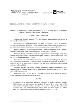
150
100
4
1
(1)
Q
Q
265.96
200
RML
OMPF
30
AS
0
15
0
RML
FMC
65
0
60
LL
Czc
30
MUZ
40
Cz
300.78
15
50
Cz
311.53
50
310.43
50
15
RML
311.69
MSV
75
GI
ER
25
RML
ACN
RML
30
RML
0
15
250
FUST
250
USS
235.03
Q
312.84
200
C
0
20
0
20
0
35
RML
OMPF
OMPF
RML
362.79
310.93
354.56
350
GG
IAN
300
0
30
300
0
RA A
311.84
332.04
RGI
OLA
15.2 %
12.7 %
25.0 %
17.4 %
14.5 %
29.5 %
19.6 %
16.4 %
Transtensive fault
Shear zone eastern boundary
Fault
2nd mylonite zone
(5.5 < g < 11.5)
Radiometric ages (Ma)
* Ar/Ar, **Rb/Sr, *** K/Ar
n=80
S1 foliation
200
IS
FR
20
0
GST
2.6 %
3.6 %
5.3 %
7.1 %
10.5 %
10.7 %
21.1 %
17.9 %
26.3 %
21.4 %
1.4 %
NE
SHEAR ZONE
GERREI UNIT
800
2.9 %
MONTE GRIGHINI UNIT
600
600
TC
FMC
10.0 %
MGt
328.84
200
18.6 %
RML
ACN RML USS
F1-F2 fold axis n=80
MGl
TC
MUZ
MGm
0
MGl
Cz
Cza
Czc
MGm
TZa
-200
Cza UMz
MGm
A’
NE
MONTE GRIGHINI UNIT
800
RML
USS
RML
MGm
600
MGt
TC
TZb
Ghenniespos
TC
400
TC
RML
PRF
Czc
MUZ
Czb
MUZ
PGm
Cza
TC
MGm
TZa
Cza
MGl
Cza
Cz
Cz
13 000 m N
GERREI UNIT
800
TC
299.03
Serra Canna
SA
150
200
30
0
250
1489
0
TZb
-200
B’
NE
CASTELLO
MEDUSA
UNIT
MONTE GRIGHINI UNIT
800
0
CSA
MGM
TZb
TZa
PRF
MSV
1490
Perda Arrubia
TC
MGm
Cz
TC
CSA USS
USS
MGt
C
C’
400
500
750
1km
M.E.Spano gratefully acknowledges the Sardinia Regional Government for the
financial support to her PhD scholarship (P. O. R. Sardegna F. S. E. Operational
Programme of the Autonomous Region of Sardinia, European Social Fund
2007–2013 - Axis IV Human Resources, Objective l.3, Line of Activity l.3.1.).
0
Financial support from Università degli Studi di Cagliari and Università degli
Studi di Pisa is aknowledged.
-200
The authors wish to thank the Ente Foreste della Regione Autonoma della
Sardegna for hospitality during the field work.
MGm
TZa
TZa
Topographic map from the 1.10.000 C.T.R. (Carte Tecniche Regionali) maps Regione Autonoma della Sardegna.
200
TC
MGl
-200
UMz
250
600
TC
TC
ACN
USS
0
1488
TZa
MGt
UMz
MGd
TC
RML
MUZ
304.53
283.54
USS
TZb
Br.cu Fogaies
400
200
MGm
SHEAR ZONE
Su Cruccuri
RML
1487
TZb
PGm
TCa
Czb
PGl
600
310.40
RML
1486
USS
TC
Cz
Acn
200
TC
TZb
Czb
MSV
SHEAR ZONE
340.76
250
8°50’00’’
400
USS
12.9 %
SW
44
Mogorella
1485
Toccori
TCa
400
TC
251.83
0
#
1484
800
Cuccuru Mannu
8.6 %
n=80
B
2
0
2km
1
(g > 11.5)
n=110
14.3 %
PRF
322.59
00
0
Truzzulla
0
S
298.21
200
250
35
TER
0
216.59
1483
20.5 %
GERREI UNIT
200
354.41
266.90
20
211.25
15
1482
(1.15 < g < 5.5)
Thrust
g <1.15)
300
8°50’00’’ East from Greenwich
UTM (Universal Transverse Mercator) Grid, Zone 32S (ED50)
209.14
Roma 1940 - Gauss Boaga Ovest
1481 000 m E
10.9 %
n=75
4414
2km
1750
13.0 %
MSV
300
1500
15.2 %
Cuccuru e Uas
0
25
13 000mN
1250
1Km
1st mylonite zone
-200
Scale 1:25.000
750
9.1 %
A
350
307.83
500
7.3 %
10.9 %
600
388.74
0
44
250
8.7 %
10.6 %
400
346.30
20
0
7.6 %
AS
332.80
213.54
245.95
(0.35 <
DU
334.86
333.10
A
30
142.87
313.16
5.5 %
SW
ACN
RML
6.5 %
F2 fold axis
800
234.10
232.90
5.3 %
4415
RML
BA
RML
RML
N
protomylonite zone
0
mineral
lineation
OMPF
250
BGR
RML
3.6 %
16
OMPF
PRA MAIORI
2km
1
OMPF
315.22
OMPF
200.28
200
1.8 %
4.3 %
mineral
lineation
Ms** 295 ± 9
Bt*** 302 ± 6
ACN
350
0
MINDAPIRA
Diorite
Monte Grighini Unit
2.2 %
3.8 %
-200
OMPF
RML
PRF
DDI
Tonalite-monzogranite
Castello Medusa Unit
0
PRF
383.70
ZIO
d
2000
Gerrei Unit
1.5 %
15.8 %
OMPF
375.24
60
1500
n=70
25
226.60
176.80
F3 fold axis
0
ACNb
ACNb
10
44
0
388.97
281.34
180.44
1000
500
0
n=150
M. Filighi
Leucogranite
18.8 %
15.7 %
344.14
25
RML
Q
12.0 %
M. Fogaies
Ms* 296 ± 1.5
Ms** 305 ± 6
0
#
384.62
300
RML
170.59
10.7 %
30.3 %
Cuccuru e’Uas
Ultramylonite
15.9 %
ACN
312.74
14
25.0 %
n=132
Q
80
MGM
45
Cataclasite
10
5.7 %
10
35
321.17
128.81
C-plane
44
RML
MGM
SGAa
SGA
ACNa
300
218.38
13.0 %
Ms**
299 ± 5
Neogene
ultramylonite zone
OMPF
321.83
ACNa
312.57
10
PRA MESA
130.41
35
ACNa
USS
RML
15
30
314.44
BUS
240.17
150.69
17
OMPF
SGA
Bt*** 304 ± 6
SW
25
40
343.51
20
338.88
IS AR
10.1 %
8.0 %
9.3 %
S2 foliation
80
RML
20
RML
6.7 %
417.80
35
20
30
5.3 %
7.2 %
OMPF
250
RML
401.43
30
250
Q
44
RML
OMPF
MGl
35
15
4.3 %
5
300
ACN
251.17
10
3
25 50 358.56
40
ACN
44
344.70
PRF
353.13
BA
75
ACNa
35
OMPF
AR
Q
ACN
M.Grighini
Bt** 294 ± 9
Bt*** 302 ± 6
20
4.0 %
n=132
OMPF
OMPF
50
3MGL
0
ACN
S-plane
401.57
RGHENTU
425.94
40
15
272.54
MGl
80
ACNb
a) acidic metavolcanics, b) metarkoses and
metasandstones (Upper Ordovician - 440 Ma)
graph of shear strain (g) vs.
width (d) of shear zone
400
25
0
25
15
Villaurbana
334.95
30
RD
70
440.25
15
0
45 453.45
355.35
350.13
50
257.99
270.39
Su Pinnoi
UMz
343.00
270.45
PE
80
50
35
RML
PRA PINNA
10
ZI
IZ
MODD
PRF
268.51
MGl
75
a
Allai
Ms* 300 ±1.2
Ms** 297 ± 5
Gerrei Unit
300
44
65
332.69
44
D
MGm
75
80
2.7 %
18
A
AN
D
SE
MASONI A
350
GA
Q
16
Cz
1.3 %
3.0 %
0
40
403.19
OMPF
85
TZ - Truzzulla Formation
N
15.2 %
244.59
0
10
ACN
USS
ON
MGd
40
MGl
40
ACN
AL
30
0.8 %
10.6 %
USS
Qd
TCb
MGl
350
270.9950
139.23
PRF
467.60
80
Qd
MGL
UMz MGm
129.17
45
b
TC
425.01
70
0
25
Qd
SU CRUCCURI
60
MGd
10
PIR
45
55
10
Q
TC
0
400
MGl
CUSSORGIU MANNU
USS 45
35
Qd
MGm
RML
Schists, micaschists with minor paragneisses (TC) and hornfelsed
schists (TCh), a) white quartzites, b) marbles (Upper Ordovivcian - Silurian)
g
0
39°54’00’’
356.76
30
0
PA
L
USS
MONTI PALLA
84.94
0
35
351.66
25
10
MGl
460.42
Qd
a
Monte Grighini Unit
6.8 %
50
M.PAGLIARTANA
TC - Toccori Formation
1.4 %
280.24
Qd
b
Ms* 302 ± 0.24
Ms** 298 ± 5
shear strain (g =2cotan2q’) inferred on the basis of angle (q’)
between shear planes (C-plane) and foliation (S-plane) in the
synkinematic intrusions
Shear zone
275.11
280.19
15
Main road
(lower-hemisphere equal-area; n = number of data)
OMPF
400
12
85
350
SU
121.69
10
45
ACN
118.55
0
30km
Tectonic sketch map of the Monte Grighini Complex
Trace of geological section
Map distribution of deformation zones
25
44
17
MGt
Czb
ACN
Q
RML
45
MGd
0
Stereographic projections of structural elements
USS
M.FILIGHI
60
Ad
401.49
60
50
45
PRF
4419
240.81
35
US
RAB
SAR
Bt** 293 ± 4
20.5 %
as
US
30
35
PAL
Posada-Asinara line
404.93
RML
LA
Ben
20
A
0
10
B
MGl
Cz
GU
E
IGH
FIL
OMPF
MGm
55
MUZ
112.25
114.07
30
M.IRONI
50
TC
75
25
92.95
SU
Qd
30
100
22
Cagliari
273.32
CO
RI
TZb
10
496.84
55
PGm
ACN
Uss
Q
Qd
512.40
513.06
40
MGl
30
USS
Br.cu Fogaies
15
MGm
40
0
RML
Qd
50
25
18
C’
Serra Capo d' Acqua
45
20
A’
MONTE GRIGHINI UNIT
a) intensely fractured medium-grained mylonitic monzogranites
(PGm) and b) mylonitic leucogranites (PGl)
271.85
30
50
80
RML
Czb
TZb
60
UMz
PGm
338.27
MGM
TC
MGl
RML
35
Csa
20
533.18
IGLESIENTE
Capo Spartivento
A
Ultramylonitic and minor mylonitic leucogranites and
monzogranites
39°54’00’’
40
336.92
15
Qd
Main thrusts
Fossiliferous locality
PG - Perdoseddu granites
OMPF
300
25
233.50
Qpd
70
00
4417.74
IS
45
MSV
70
75
80
IL
25
60
MGm
450
ARBURESE
Strike-slip fault
b
350
CUCCURU
E’UAS
250.58
75
400
MSV
Cz
PGl
185.21
184.88
283.12
0
25
343.36
PE
60
TCh
RC
25
MGt
PO
PRF
PRF
MGd
CZa
USS PGm
RD
C
35
40
80
O
SULC
Metarkoses, quartzites and metaconglomerates (Upper Ordovician)
35
0
45
Qd
500
371.17
40
MGm
80
R
AA
Transtensive fault
Normal fault
a
UMz - Ultramylonite zone
148.40
RU
C
ON
577.44
Qd
40
A
50
TCb
400
External zone with
thrusts and folds
AN
EI
MGM - Metarcose di Genna Mesa
a
MGM
BIA
CID
GERR
Cz - Cataclasite zone
Csa
270.42
TZb
SAR
External zone
350
USS
20
Q
TCa
80
399.05
12
Mt.Grighini
Ms** 307 ± 5
4420
400
45
USS
60
I
S
BA
MGl
MGm
80
40
MUZ
170.62
A
MGl
Main thrust
Cataclastic rocks with small bodies of a) shale, b) silicized
metalimestones and c) hornfels
c
b
10
D
E
GH
DE S
USS
225.54
600
617.12
LATE VARISCAN SHEAR ZONE
A
A PIR 296.25
206.61
Csa
DU
Quartzites, metasandstones and metaconglomerates
(Middle - ?Upper Ordovician)
Grey-greenish phyllites, a) marbles and calc-schists
(?Silurian - ?Lower Carboniferous)
0
C’’
55
70
614.26
80
SGA 40
ACN
45
15
MGd 600
75
10
USS
MSV
19
ZU
400
RML
80
27
415.11
A
S’EN
30
20
M. CRISTU
25
PRF
MUZ
0
80
25
0
265.52
Ad
50
60
264.32
300
MUZ - Metarenarie di Su Muzzioni
CSA - Complesso di Sa Lilla
15
OMPF
USS
Funt.na s'Eremita
662.72
669.74
UZ
75
35
65
80
50
35
TR
430.51
70
433.36
20
Ad
44
MGm
20
RML
44
Qd
432.07
0
BARBAGIA
Riu Gruppa-Castello
Medusa Unit
Monte Grighini Unit
Axial plane trace of F3 antiform
and synform
CASTELLO MEDUSA UNIT
a
65
TZb
15
Gerrei Unit
Axial plane trace of F2 antiform
and synform
Basic to intermediate metavolcanites (Middle - ?Upper Ordovician)
Q
OMPF
40
Nuoro
MSV - Monte Santa Vittoria Formation
0
Qd
Cz
10
Z
TZb
TCa
663.02
647.95
I
UZZ
MAT
370.96
TC
35
65
USS
35
PGm
60
Calc-alkaline metapyroclastites with rhyolitic-dacitic composition
(?Middle - Upper Ordovician)
4421
USS
250
Q
Ad
MGm
Sandstones and quartzite sandstones. Fluvial-deltaic deposits
(Lower Eocene)
Meana Sardo Unit
IS
OMPF
297.27
50
70
PRF - ‘Porfiroidi’
Ad - Aplite and pegmatite dykes
TC
293.66
MGl
Qd
FMC - Monte Cardiga Formation
Posada
Arburese Unit
Axial plane trace of F1 antiform
and synform
55
TCh
N.ghe MAIORI
Metarkoses, quartzites and metaconglomerates (Upper Ordovician)
Qd - Quartz dykes,
Qpd - Quartz-plagioclase porphyry dykes
30
50
303.12
65
Qd
s'Ispelunca Minore
TZa
MGd
550
75
44
100
TZb
25
Csaa
18
Mylonitic stretching lineation
Continental heterometric deposits (Upper Oligocene Lower Aquitanian)
LATE VARISCAN DYKE SYSTEM
RML
Csa
A
MGd
Qd
Q
ED
Cz
USS
350366.84
80
649.28
Qd
85
244.95
55
MGl
70
OMPF
OMPF
50
20
Sassari
Sarrabus Unit
MGM - Metarcose di Genna Mesa
0
70
Nuraxeddu
POS
15
235.14
RML
GHENNIES
380.59
Qd
55
Cz
40
Q
N
External nappes
USS - Ussana Formation
VARISCAN BASEMENT
RML
TZb
80
MGd
A
MGM
45
0
65
650
MGm
290.27
70
GALLURA
Barbagia Unit
Mylonitic/ultramylonitic foliation
30
0
382.52
LA
552.97
386.90
OMPF
50
NT
75
M.GRIGHINI
670.22
TCh
50
350
OMPF
195.76
Qd
PAL
Internal nappes
Stretching/mineral lineation
300
44
25
DD
350
USS
25
150
UMz
US
XE
I
CH
MGt
50
270.90
250
80
ACN
403.01
TCa
Qd
TZa
TIN
MGd
MGd
21
50
70
80
RML
Ad 370.99
0
M.za s' Iscibi
RML
40
55
25
MGl
15
4422
OMPF
266.95
25
85
65
TZb
60
70
RML
40
100
400.63
539.69
TCh
20
OMPF
Funt.na Cruccuris
za
100
CUCCURU MANNU
80
45
USS
45
350
22
RML
40
45
Mit
ACN
PRF
40
12
409.21
60
60
TCh
IS
ACN
MGd
2
400
PRF
350
MGt
75
ACN
I. Asinara
0
00
TR
10
0
USS
USS
10
Sd
500 km
Variscan massifs
15
TC
15
60
310.27
Co
0
75
Py
Nappe zone
Metapelites, a) fossiliferous metasiltites, b) fossiliferous
metalimestones (encrinite) (Upper Ordovician)
a
OM
Amphibolite-facies
metamorphic complex
ACN - Argilloscisti di Riu Canoni
b
Dacitic to rhyodacitic pyroclastic flows (Oligo-miocene)
DU
35
40
Pe/Br
Migmatite complex
Cataclastic foliation
Bau Accas
55
23
Q
PO
RA
DA
TCh
TZb
44
RML
AA
Alps
Hv
Axial zone
Black shales; a) nodular metalimestones (Silurian Lower Devonian)
OMPF - Calc-alkaline volcanics
B’
65
TOCCORI
70
TCa
400
39°57’00’’
20
PE
Cz
Variscan granitoids
F3 fold axis
SGA - ‘Scisti Neri’ Formation
a
Heterometric and heterogenic conglomerates with cineritic matrix
(Upper Aquitanian - Lower Burdigalian)
BM
z
MD
MC
F2 fold axis
GERREI UNIT
RML - Marmilla Formation
OMPF
RDU
Q
140.69
15
TZb
80
40
45
373.99
65
25
20
USS
Qd
USS
PERDA
R
CO
65
250
44
350
Cz
35
75
TC
S
A
ON
55
Qd
60
75
ACN
Qd Cz
60
TCa
TU
SAN
40
350
80
0
15
70
MGl
284.29
30
300
80
Q
15
Allai
Ib
Sp
Equigranular fine-grained diorites
Alternation of arenaceous and clay marls (Upper Burdigalian Middle Langhian)
250
OMPF
200
306.00
S3 axial plane foliation
Post-Variscan covers
MGd - Monte Grighini diorites
200
OMPF
197.38
294.92
57
20
40
A’
50
MGt - Monte Grighini tonalites
STz
Am
F1 fold axis
GST - Marne di Gesturi Formation
65236.57
15
ACN
191.16
40
TCa
OMPF
LE
UMz272.88
MGm
Cz
PRF
PRF
23
MGm
20
350
ACN
25
44
TZb
200
45
278.00
60
S2 axial plane foliation
Foliated fine-grained tonalites
Q
M
S
Rhz
Protomylonitic-mylonitic medium-grained biotite-bearing
monzogranites
Subalkaline and alkaline basaltic to dacitic lavas (Pliocene)
150
60
MGl
75
M.PODDIGAS
171.65
18
OMPF
PU
TC
BGR - Basalti delle Giare
39°57’00’’
200
Qd
44
C
PI
144.20
A
ANN
ALA
AP
USS
40
200
TCh
15
2
MGm
MGm
80
200.72
242.10
50 252.23
Lz
20
162.10
45
80
UMz
PRF
R
24
50
150
MGl
295.10
Alluvial terraced and in evolution deposit (Holocene - Pleistocene)
0
25
O
CI
550
0
RML
350
20
Cz
ACN
Q - Quaternary deposits
Q
20
15
OMPF
RE
MGl
80
Q
GI
OS
70
356.95
MGm
N
MGm - Monte Grighini monzogranites
154.66
15
0
BGR
Geological map of the Variscan chain of Sardinia
S1 axial plane foliation
0
100
350
251.11
24
30
RI
BGR
376.99
Protomylonitic-mylonitic fine-grained muscovite-bearing
leucogranites
POST-PALEOZOIC SEDIMENTARY AND VOLCANIC
SUCCESSION
OMPF
150
0
SPAS
PERDAS AUSS
STRUCTURAL
SYMBOLS:
MGl - Monte Grighini leucogranites
317.84
15
TC
MONTE GRIGHINI INTRUSIVE COMPLEX (305-290 Ma)
GEOLOGICAL LEGEND:
327.40
91.29
IO
MA
Q
25
Q
150.48
166.23
M.OLLASTRA
44
OMPF
25
0
35
160.20
MGm
BGR
44
300
OMPF
RA
194.05
284.98
CO
312.46
SER
MGm
TC
355.51
Q
FUS
0
(3) ARPAS, Dipartimento provinciale di Sassari
LA
OMPF
15
(1) Dipartimento Scienze della Terra, Università di Pisa (2) Dipartimento Scienze Chimiche e Geologiche, Università di Cagliari
CSA
U
MP
N
DI
BIANC
A
250
USS
USS
DE
OMPF
137.46
OMPF
Q
44
132.42
200
200
105.48
10
0
315.08
MGM
CSA
100
(2)
(1)
(2)
(3)
(2)
G. Musumeci, M.E. Spano, G.P. Cherchi, M. Franceschelli, P.C. Pertusati, G. Cruciani
MGm
MGM
150
Q
BGR
25
Geological map of Monte Grighini Variscan Complex (Sardinia, Italy)
251.19
209.07
Q
Q
90
250
0
15
RML
00
OMPF
OMPF
OMPF
GST
89
0
50
150
0
OMPF
Q
4
8°50’00’’
84.82
150
10
88
20
26
4
A
0
#
81.56
44
487
486
85
RR
4
NU
84
300
4
20
0
83
10
4
350
82
AG
4
SA
81 000 m E
200
4
C’’
© Journal of Maps, 2014
Scarica