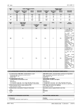
AD 2 LICR 1-1
AIP - Italia
1 LICR
Indicatore di località
Location indicator
REGGIO CALABRIA
Nome dell’ Aeroporto
Aerodrome name
2 DATI AMMINISTRATIVI E GEOGRAFICI DELL’AEROPORTO
AERODROME GEOGRAPHICAL AND ADMINISTRATIVE DATA
1 Coordinate ARP
38°04'19''N 015°39'13''E
2 Direzione e distanza dalla città
2.16 NM S
3 Elevazione/Temperatura di riferimento
95 FT / 30.3 °C
4 Variazione magnetica/Variazione annuale
2° E (2005.0) / 4'E
5 Autorità amministrativa aeroportuale
ENAC -DA Reggio Calabria
89131 Ravagnese (Reggio Calabria)
Tel +39 0965 638219/220
fax: +39 0965 638223
e-mail: [email protected]
ARP coordinates
38°04'19''N 015°39'13''E
Direction and distance from city
2.16 NM S
Elevation/Reference temperature
95 FT / 30.3 °C
Magnetic variation/Annual change
2° E (2005.0) / 4'E
Aerodrome administration authority
ENAC -DA Reggio Calabria
89131 Ravagnese (Reggio Calabria)
Tel +39 0965 638219/220
fax: +39 0965 638223
e-mail: [email protected]
Esercente
SOGAS SpA
Tel +39 0965 645201 fax +39 0965 630988
Telex SITA: REG SGXH
Aerodrome operator
SOGAS SpA
Tel +39 0965 645201 fax +39 0965 630988
Telex SITA: REG SGXH
Autorità ATS
ENAV S.p.A.
UAAV Reggio Calabria
Tel: +39 0965 688001; fax: +39 0965 688023
e-mail: [email protected]
6 Tipo di traffico consentito (IFR/VFR)
IFR/VFR
7 Note
1)
Vedi tabella 20, tabella 22.1 e tabella 23
2)
Codice di riferimento Annesso 14 infrastrutture di volo: 4C
ATS authority
ENAV S.p.A.
UAAV Reggio Calabria
Tel: +39 0965 688001; fax: +39 0965 688023
e-mail: [email protected]
Type of traffic permitted (IFR/VFR)
IFR/VFR
Remarks
1)
See table 20, table 22.1 and table 23
2)
Ref code Annex 14 flight infrastructure: 4C
3 ORARIO DI SERVIZIO
OPERATIONAL HOURS
1 Amministrazione aeroportuale
H24
2 Dogana e immigrazione
0430-2300 (0330-2200)
3 Servizio sanitario
H24
4 AIS
0500-2300 (0400-2200)
5 ARO
0500-2300 (0400-2200)
6 METEO
0500-2300 (0400-2200)
7 ATS
0500-2300 (0400-2200)
8 Rifornimento
Autobotte AGIP: tutti i giorni 0500-1900 (0400-1800)
Altri orari chiamando il +39 0965 643430 dalle 0500 alle 1900
(0400-1800)
AVGAS 100LL disponibile HR: HJ -/+30
9 Handling
0500-2300 (0400-2200); 2300-0500 (2200-0400) su richiesta
10 Servizi di sicurezza
H24
11 De-icing
NIL
12 Note
NIL
4 SERVIZI DI SUPPORTO ED ATTREZZATURE
Aerodrome Administration
H24
Customs and immigration
0430-2300 (0330-2200)
Health and sanitation
H24
AIS
0500-2300 (0400-2200)
ARO
0500-2300 (0400-2200)
METEO
0500-2300 (0400-2200)
ATS
0500-2300 (0400-2200)
Fuelling
AGIP tank-truck: every day 0500-1900 (0400-1800)
Other hours calling +39 0965 643430 from 0500 to 1900 (04001800)
AVGAS 100LL available HR: HJ -/+30
Handling
0500-2300 (0400-2200); 2300-0500 (2200-0400) on request
Security
H24
De-icing
NIL
Remarks
NIL
HANDLING SERVICES AND FACILITIES
1 Attrezzatura di carico e scarico merci
Cargo-handling facilities
SOGAS SpA: attrezzature imbarco - loader - dollyes - rifornimento SOGAS SpA: boarding facilities - loaders - dollyes - water supply idrico - handler, ecc.
handler, etc.
ALITALIA in autoproduzione:
ALITALIA self sufficient:
trattori - elevatori - carrelli - nastri trasportatori
tractors - elevators - trolleys - conveyor belts
2 Tipi di carburante/Olio
Fuel/Oil types
JET A1, AVGAS 100LL / NIL
JET A1, AVGAS 100LL / NIL
3 Capacità di rifornimento
Fuelling capacity
33000 litri + 29000 litri
33000 litres + 29000 litres
4 Sistema de-icing
De-icing facilities
NIL
NIL
ENAV - Roma
AIRAC effective date 07 MAR 2013
(A1/13)
AD 2 LICR 1-2
AIP - Italia
5 Hangar per aeromobili in transito
Hangar space for visiting aircraft
NIL
NIL
6 Servizio riparazioni per aeromobili in transito
Repair facilities for visiting aircraft
Attrezzatura normalmente disponibile per le riparazioni: piccole Repair facilities normally available: minor repairs by ALITALIA and
riparazioni tramite ALITALIA e Aeroclub
Aeroclub
7 Note
Remarks
1)
Marshall SOGAS SpA; Alitalia in autoproduzione
1)
Marshall SOGAS SpA; Alitalia self sufficient
5 SERVIZI PER I PASSEGGERI
PASSENGER FACILITIES
1 Alberghi
Alberghi in città
2 Ristoranti
Tavola calda fino alle 2200 (2100)
3 Trasporti
Taxi - servizio urbano - collegamento marittimo con Messina
4 Servizio medico
Pronto soccorso, infermeria, medico, 2 ambulanze
Orario: H24
Ospedale in città km 5
5 Banca e ufficio postale
Bancomat
6 Ufficio turistico
Assessorato Regione Calabria (I.A.T.)
7 Note
NIL
Hotels
Hotels in town
Restaurants
Snack-bar until 2200 (2100)
Transportation
Taxi - bus service - maritime connection to Messina
Medical facilities
First aid treatment, infirmary, medical assistance, 2 ambulances
Hour: H24
Hospital in town 5 km
Bank and Post office
Cash dispenser
Tourist office
Assessorato Regione Calabria (I.A.T.)
Remarks
NIL
6 SERVIZI ANTINCENDIO E DI SOCCORSO
RESCUE AND FIRE FIGHTING SERVICES
1 Categoria servizio antincendio aeroportuale
CAT 7 ICAO
2 Equipaggiamento per il soccorso
NIL
3 Rimozione aeromobili in difficoltà
NIL
4 Note
NIL
Aerodrome category for fire fighting
CAT 7 ICAO
Rescue equipment
NIL
Capability for removal of disabled aircraft
NIL
Remarks
NIL
7 DISPONIBILITA’
PISTE
STAGIONALE
E
SISTEMI
DI
1 Equipaggiamenti di pulitura
Autospazzatrice
2 Priorità
NIL
3 Note
1)
Equipaggiamento grip tester disponibile
PULITURA SEASONAL AVAILABILITY AND CLEARING
Types of clearing equipment
Self sweeper
Clearance priorities
NIL
Remarks
1)
Grip tester equipment available
8 DATI RELATIVI AI PIAZZALI, ALLE VIE DI RULLAGGIO ED APRONS, TAXIWAYS AND CHECK LOCATIONS DATA
ALLE PIAZZOLE PROVA
1 Superficie e resistenza dell’area di stazionamento
Apron General Aviation
Superficie: ASPH
Resistenza: PCN 21/F/C/W/T
Main apron
Superficie: CONC/ASPH
Resistenza: PCN 40/R/B/W/T
2 Larghezza, superficie e resistenza delle TWY
A
Larghezza: 15 M
Superficie: ASPH
Resistenza: PCN 26/F/C/W/T
B
Larghezza: 30 M
Superficie: ASPH
Resistenza: PCN 40/R/B/W/T
D
Larghezza: 10 M
Superficie: ASPH
Resistenza: PCN 08/F/C/W/U
3 Localizzazione/Elevazione ACL
Vedi carta AOC in vigore
4 Punto di controllo VOR/INS
NIL / NIL
ACL location/Elevation
See AOC in force
VOR/INS checkpoints
Remarks
TWY C chiusa
AIRAC effective date
TWY width, surface and strength
A
Width: 15 M
Surface: ASPH
Strength: PCN 26/F/C/W/T
B
Width: 30 M
Surface: ASPH
Strength: PCN 40/R/B/W/T
D
Width: 10 M
Surface: ASPH
Strength: PCN 08/F/C/W/U
NIL / NIL
5 Note
1)
Apron surface and strength
Apron General Aviation
Surface: ASPH
Strength: PCN 21/F/C/W/T
Main apron
Surface: CONC/ASPH
Strength: PCN 40/R/B/W/T
07 MAR 2013 (A1/13)
1)
TWY C closed
ENAV - Roma
AD 2 LICR 1-3
AIP - Italia
9 GUIDA AI MOVIMENTI A TERRA E SISTEMI DI CONTROLLO E SURFACE MOVEMENT GUIDANCE AND CONTROL SYSTEM AND
SEGNALAZIONE
MARKINGS
1 Segnale di identificazione stand aeromobili, linee guida per
TWY e sistemi di guida per parcheggio a vista negli stand
degli aeromobili
Vedi carta APD in vigore
2 Illuminazione e segnaletica per RWY e TWY
Vedi carta AD in vigore
3 Barre d’arresto
Vedi carta AD in vigore
4 Note
NIL
10 OSTACOLI AEROPORTUALI
Use of aircraft stand identification sign, TWY guide lines and
visual docking/parking guidance system of aircraft stands
See APD chart in force
RWY and TWY markings and lights
See AD chart in force
Stop bars
See AD chart in force
Remarks
NIL
AERODROME OBSTACLES
Nelle aree di avvicinamento e decollo
In approach and take off areas
RWY e Area
interessata
RWY and Area
affected
a
1
Tipo di ostacolo
Elevazione
Segnaletica e Luci
Obstacle type
Elevation
Markings and Lights
b
Nell’area di circuitazione e all’interno
dell’aerodromo
In circling area and at aerodrome
2
Coordinate
Tipo di ostacolo
Coordinate
Coordinates
Elevazione
Coordinates
Segnaletica e Luci
Obstacle type
Elevation
Marking and Lights
c
a
b
Vedi AOC in vigore
See AOC in force
Note
Remarks
3
NOTE
1)
Causa ostacoli intorno all'aeroporto si applica quanto segue
a)
RWY 33: utilizzabile con le seguenti caratteristiche:
pendenza della superficie di avvicinamento 1:30
superficie curva, vedere Carta Ostacoli tipo "A" e tipo “B”
raggio nominale della curva 3070 m
b)
RWY 15: superficie di avvicinamento utilizzabile 1:30
2)
Traffico da/per l'aerodromo ed in avvicinamento a Messina città prestare attenzione a un ostacolo (pilone) HGT 236 m/774 ft AMSL (234
m/767 ft AGL), PSN 38°15'52"N 015°39'06"E situato nello stretto di Messina, illuminato con luci ad alta intensità, HR 1630-0500
REMARKS
1)
Due to obstacles around the airport FLW apply
a)
RWY 33: usable with FLW characteristics:
approach surface slope 1:30
curved surface see AOC type "A" and type “B”
nominal curve radium 3070 m
b)
RWY 15: approach surface slope 1:30 apply
2)
Traffic to/from aerodrome and approaching Messina town pay attention to obstacle (pylon) HGT 236 m/774 ft AMSL (234 m/767 ft AGL),
PSN 38°15'52"N 015°39'06"E located Stretto di Messina, lighted by very high intensity lamps, HR 1630-0500
11 INFORMAZIONI METEOROLOGICHE
METEOROLOGICAL INFORMATION
1 Ufficio METEO di riferimento
REGGIO CALABRIA
2 Orario di servizio
0500-2300 (0400-2200)
3 Ufficio responsabile preparazione TAF/Periodo di validità
UPM ROMA / 9H
4 Tipo di previsione per l’atterraggio/Intervallo di emissione
NIL / NIL
5 Briefing e consultazione fornita
Consultazione personale
6 Documentazione di volo/Lingua usata
Testi in linguaggio chiaro abbreviato - carte
IT/EN
7 Carte e documentazione disponibili per consultazione
Associated MET office
REGGIO CALABRIA
Hours of service
0500-2300 (0400-2200)
Office responsible for TAF preparation/Period of validity
UPM ROMA / 9H
Type of landing forecast/Interval of issuance
NIL / NIL
Briefing and consultation provided
Personal consultation
Flight documentation/Language used
Abridged plain language texts - Charts
IT/EN
Charts and other information available for briefing or
consultation
P,W,T
P,W,T
8 Mezzi aggiuntivi disponibili per l’informazione
Supplementary
equipment
available
for
providing
information
TELEFAX
TELEFAX
9 Enti ATS destinatari delle informazioni
ATS units provided with information
Reggio Calabria TWR - Reggio Calabria APP
Reggio Calabria TWR - Reggio Calabria APP
10 Informazioni climatologiche e informazioni supplementari
Climatological information and additional information
1)
Ufficio METEO di riferimento:
1)
Associated MET office:
tel: + 39 0965 688016; fax: + 39 0965 642238
tel: + 39 0965 688016; fax: + 39 0965 642238
2)
UPM ROMA:
2)
UPM ROMA:
tel: + 39 06 79086733/5; fax: + 39 06 79086459
tel: + 39 06 79086733/5; fax: + 39 06 79086459
3)
Aeroporto occasionalmente interessato da fenomeni di wind 3)
Aerodrome occasionally affected by terrain-induced wind shear
shear orografico, in prevalenza con venti settentrionali, che
phenomena, mostly originated by northern winds accelerated
accelerano incanalandosi attraverso i rilievi dello Stretto di
by the channeling effect provided by the mountains
Messina.
overlooking Messina Strait.
ENAV - Roma
AIRAC effective date
10 JAN 2013
(A12/12)
AD 2 LICR 1-4
AIP - Italia
12 CARATTERISTICHE FISICHE DELLE PISTE
RUNWAY PHYSICAL CHARACTERISTICS
Designazione
NR RWY
Designation
QFU
Dimensioni RWY
Dimension of RWY
(M)
Resistenza e superficie di
RWY
Strength and surface of
RWY
Coordinate THR
THR coordinates
1
2
3
5
11
111°
1699 x 45
29
291°
1699 x 45
15
151°
1998 x 45
33
331°
1998 x 45
4
Resistenza/Strength:
da/from THR 11 a/to 575 M:
PCN 46/F/B/W/T
da/from 575 M a/to THR 29:
PCN 81/F/B/W/T
Superficie/Surface:
ASPH
Resistenza/Strength:
da/from THR 11 a/to 575 M:
PCN 46/F/B/W/T
da/from 575 M a/to THR 29:
PCN 81/F/B/W/T
Superficie/Surface:
ASPH
Resistenza/Strength:
da/from THR 15 a/to THR 33
= PCN 44/F/B/W/T
Superficie/Surface:
ASPH
Resistenza/Strength:
da/from THR 15 a/to THR 33
= PCN 44/F/B/W/T
Superficie/Surface:
ASPH
Designazione
NR RWY
Designation
1
Pendenza di
RWY-SWY
Slope
7
Vedi AOC in vigore
See AOC in force
Vedi AOC in vigore
See AOC in force
Vedi AOC in vigore
See AOC in force
Vedi AOC in vigore
See AOC in force
11
29
15
33
Designazione
NR RWY
Designation
1
11
29
Non applicabile
Not applicable
33
NIL
42.2 FT / NIL
38°04'45.98''N
015°38'46.33''E
83.9 FT / 83.9 FT
38°03'57.21''N
015°39'18.03''E
34.2 FT / 36.3 FT
Dimensioni strip
strip dimension
(M)
10
Dimensioni RESA
RESA dimension
(M)
11
NIL
NIL
1819 x 150
NIL
NIL
60 x 150
1819 x 150
150 x 90
NIL
60 x 150
2118 x 150
240 x 90
NIL
120 x 150
2118 x 150
150 x 90
Note
Remarks
NIL
NIL
1) DTHR 254 m
2) Testate in calcestruzzo/Heads in concrete
1) DTHR 54 m
2) Testate in calcestruzzo/Heads in concrete
DECLARED DISTANCES
Designazione RWY
RWY designator
1
11
29
15
33
START POINT RWY 33
TORA
(M)
2
NU
1699
1998
1998
2061
TODA
(M)
3
NU
1759
2058
2118
2181
14 LUCI DI AVVICINAMENTO E LUCI PISTA
ASDA
(M)
4
NU
1699
1998
1998
2061
AVVICINAMENTO
APPROACH
Lunghezza
Intensità
Length
Intensity
(M)
THR
VASIS
PAPI
MEHT
(M)
Colore
Colour
TDZ
Lunghezza
Length
(M)
2.1
NIL
NIL
2.2
NIL
NIL
2.3
NIL
NIL
3
NIL
NIL
4.1
NIL
NIL
15
SALS
240
NIL
THR
G
NIL
33
ALS
NIL
NIL
THR
G
NIL
10 JAN 2013 (A12/12)
LDA
(M)
5
NU
NU
1744
1944
-
APPROACH AND RUNWAY LIGHTING
1
11
29
AIRAC effective date
38°04'09.21''N
015°39'27.06''E
Dimensioni CWY
CWY dimension
(M)
9
13 DISTANZE DICHIARATE
Tipo
Type
38.1 FT / NIL
13
15
RWY
ID
38°04'30.36''N
015°38'22.69''E
Dimensioni SWY
SWY dimension
(M)
8
OFZ
Obstacle free zone (OFZ)
12
NIL
NIL
THR ELEV, MAX TDZ ELEV
della RWY per APCH di
precisione
THR ELEV, MAX TDZ ELEV
of precision APCH RWY
6
4.2
3.25°
2 barre
wings
3.50°
2 barre
wings
4.3
NIL
NIL
5
NIL
NIL
16.0
NIL
18.0
NIL
ENAV - Roma
AD 2 LICR 1-5
AIP - Italia
RWY
ID
ASSE CENTRALE PISTA
RCL
Spaziatura
Colore
Spacing
Colour
(M)
Lunghezza
Length
(M)
Intensità
Intensity
Lunghezza
Length
(M)
7.1
NIL
600
1099
240
1156
600
60
1336
600
1
11
6.1
NIL
6.2
NIL
6.3
NIL
6.4
NIL
29
NIL
NIL
NIL
NIL
15
NIL
NIL
NIL
NIL
33
NIL
NIL
NIL
NIL
RWY
ID
FINE PISTA
RWY END
Colore
Colour
1
11
29
15
33
SWY
Lunghezza
Length
(M)
Colore
Colour
9.1
NIL
NIL
NIL
9.2
NIL
NIL
NIL
8
R
R
R
R
NIL
NIL
BORDO PISTA
RWY EDGE
Spaziatura
Colore
Spacing
Colour
(M)
Intensità
Intensity
7.2
NIL
60
60
60
60
60
60
60
60
7.3
NIL
Y
W
R
W
Y
R
W
Y
7.4
NIL
VRB
VRB
VRB
VRB
VRB
VRB
VRB
VRB
RTIL
CGL
Note
Remarks
10
NIL
NIL
2
11
NIL
NIL
NIL
12
NIL
NIL
NIL
1)
Luci
di
avvicinamento/
Approach Lighting:
ALS CAT 1 + EFAS
RLI (RWY LEAD-IN)
Sistemi
luminosi
curvi RWY LEAD-IN
a partire dal MM/
ALS CAT 1 + EFAS
RLI (RWY LEAD-IN)
curved
Lighting
System beginning
from MM
2
2) PAPI: Altezza di
a sinistra della / attraversamento
left RWY THR della THR: 59 ft;
33
assi del sistema
spostati in senso
orario di 5° da RCL
RWY 33, utilizzabile
solo in associazione
con
i
sistemi
luminosi
di
avicinamento/THR
crossing HGT: 59
ft; axis of the
system
displaced
5° clockwise from
RCL RWY 33 usable
only
associated
with
Approach
Lighting Systems
15 ILLUMINAZIONE AGGIUNTIVA, ALIMENTAZIONE SECONDARIA OTHER LIGHTING, SECONDARY POWER SUPPLY
1 Localizzazione ABN/IBN, caratteristiche e orari
Coordinate ABN: 38°04'21''N 015°39'15''E
Caratteristiche: ABN rotante a luce bianca/verde
Orario: SS-30/SR+30 durante l'orario operativo ATS
2 Localizzazione LDI e luci
Localizzazione anemometro e luci
LDI: NIL
Anemometri:
1) Circa 172 m Nord dopo THR33, circa 80 m lato destro RCL
2) Circa 30 m dopo THR15, circa 156 m lato destro RCL
3) Circa 474 m Sud dopo THR 15, circa 198 m lato destro RCL
4) Circa 172 m Nord dopo THR 33, circa 80 m lato destro RCL
5) Circa 40 m dopo THR 15, 468 m a destra RCL
3 Illuminazione bordo e asse centrale TWY
Vedi carta AD in vigore
4 Alimentatore secondario/Tempo di intervento
GEIA/7sec
5 Note
NIL
16 AREA DI ATTERRAGGIO ELICOTTERI
1 Posizione
NIL
ENAV - Roma
ABN/IBN location, characteristics and hours of operation
ABN Coordinates: 38°04'21''N 015°39'15''E
Characteristics: ABN white/green revolving light
Hours: SS-30/SR+30 during ATS operating hours
LDI location and lights
Anemometer location and lights
LDI: NIL
Anemometers:
1) About 172 m North after THR 33, about 80 m right side RCL
2) About 30 m after THR15, about 156 m right side RCL
3) About 474 m South after THR15, about 198 m right side RCL
4) About 172 m North after THR 33, about 80 m right side RCL
5) About 40 m after THR 15, 468 m right side RCL
TWY edge and centre line lighting
See AD chart in force
Secondary power supply/Switch over time
GEIA/7 seconds
Remarks
NIL
HELICOPTERS LANDING AREA
Position
NIL
AIRAC effective date 04 APR 2013
(A2/13)
AD 2 LICR 1-6
AIP - Italia
2 Elevazione
NIL
3 Dimensioni, superficie, resistenza, segnaletica
NIL
4 Orientamento
NIL
5 Distanze dichiarate
NIL
6 Luci
NIL
7 Note
NIL
Elevation
NIL
Dimensions, surface, strength, marking
NIL
Bearing
NIL
Declared distances
NIL
Lighting
NIL
Remarks
NIL
17 SPAZIO AEREO ATS
ATS AIRSPACE
Designatore e limiti laterali
Designation and lateral limits
Limiti
verticali
Vertical
limits
Classificazione dello
spazio aereo
Airspace
classification
1
Reggio Calabria ATZ
Cerchio di raggio/Circle of radius 3.0
NM
centrato su/centred on:
38°05'00''N 015°39'00''E
2
3
2000 FT
AGL
D
Nominativo
Call sign
2
Frequenza MHZ
Frequency MHZ
3
NIL
121.500 MHZ
0500-2300 (0400-2200) NIL
Reggio APP
Reggio TWR
120.275 MHZ
118.250 MHZ
0500-2300 (0400-2200) NIL
0500-2300 (0400-2200) NIL
VDF
VORTAC
(3° E-2010.0)
DVOR/DME
(2° E-2010.0)
NDB
AIRAC effective date
5
6
7000 FT
1) WI Reggio Calabria
CTR
Orario
Operational hours
4
Note
Remarks
5
RADIO NAVIGATION AND LANDING AIDS
ID
FREQ
Orario
Operational
hours
Coordinate
antenna
Antenna site
coordinates
(WGS84)
Elevazione
antenna
DME
Elevation of
DME antenna
Copertura operativa
nominale
Limitazioni
Designated operational
coverage
Limitations
Note
Remarks
2
3
4
5
6
7
8
CAT di/of ILS
(VAR ILS/VOR)
1
Note
Remarks
ATS COMMUNICATION FACILITIES
19 RADIOASSISTENZE ALLA NAVIGAZIONE E ALL’ATTERRAGGIO
Tipo di
radioassistenza
Type of aid
Altitudine di
transizione
Transition
altitude
Reggio TWR
EN / IT
18 SERVIZI DI COMUNICAZIONE ATS
Servizio
Service
1
Emergenza
Emergency
APP
TWR
Nominativo
dell’unità ATS
Lingua
ATS unit call sign
Language
4
Reggio
Calabria
Gonio
homer
NIL
H24
38°04'41.0''N
015°38'38.2''E
CDC
117.30
MHZ
CH 120X
VOR
H24
TACAN
H24
VOR
38°45'21.1''N
016°22'08.9''E
TACAN
38°45'21.1''N
016°22'08.9''E
DVOR
H24
DME
H24
DVOR
38°04'35.7''N
015°38'43.0''E
DME
38°04'35.7''N
015°38'42.5''E
RCA
RCA
111.00
MHZ
CH 47X
325.00
KHZ
04 APR 2013 (A2/13)
H24
38°00'46.2''N
015°39'00.8''E
NIL
998 M AMSL
26 M AMSL
NIL
1) Disponibile su
richiesta
sulle
frequenze di APP,
limitazioni a/limitations at TWR
ed
30 NM
emergenza/
020°/260° MRA 15000 FT
Available
on
260°/020° MRA 10000 FT
request on APP,
TWR
and
emergency
frequencies
200 NM/60000 FT
limitazioni a/limitations
40 NM
060°/150° MRA 4500 FT
150°/220° MRA 9500 FT
220°/330° MRA 4500 FT
330°/060° MRA 7500 FT
at
1) MAINT:
Primo e terzo FRI di
ogni mese / first
and third FRI each
month: 0700-0900
(0600-0800)
Settore/sector
000°/315°:
40 NM/25000 FT
Settore/sector
315°/360°:
80 NM/25000 FT
limitazioni a/limitations at
25 NM
060°/170° MRA 15000 FT
170°/230° MRA 5000 FT
230°/060° MRA 9000 FT
1) MAINT:
Primo THU di ogni
mese/first
THU
each month: 13001600 (1200-1500)
50 NM
limitazioni
50 NM
020°/070°
070°/160°
160°/230°
230°/290°
290°/020°
1) MAINT:
Primo FRI di ogni
mese / first FRI
each month: 12001500 (1100-1400)
a/limitations
NU
MRA 12000 FT
MRA 5000 FT
NU
MRA 12000 FT
at
ENAV - Roma
AD 2 LICR 1-7
AIP - Italia
Tipo di
radioassistenza
Type of aid
ID
FREQ
Orario
Operational
hours
Coordinate
antenna
Antenna site
coordinates
(WGS84)
Elevazione
antenna
DME
Elevation of
DME antenna
Copertura operativa
nominale
Limitazioni
Designated operational
coverage
Limitations
Note
Remarks
2
3
4
5
6
7
8
CAT di/of ILS
(VAR ILS/VOR)
1
RWY 33
LOC
(2° E-2005.0)
REG
109.30
MHZ
H24
38°02'44.6''N
015°39'52.3''E
NIL
limitazioni a/limitations
10 NM MRA 3500 FT
1) LOC: COV ridotta
a/reduced to 18
NM. Non utilizzabile
per
avvicinamenti
in
automatico
entro/Not
usable
for
coupled
approach inside 5
NM RCA DME.
Non
utilizzabile
dopo aver sorvolato
in avvicinamento/
Not usable after
overflying inbound
RCA NDB/OM.
di
at Settore
avvicinamento
utilizzabile/Front
course reliable WI
+/- 15°.
2)L'indicazione
fornita (017°) di
orientamento
magnetico, non è
allineata con l'asse
longitudinale della
RWY33/The
indication supplied
(017°)
magnetic
track, is not aligned
with
RWY33
longitudinal axis.
DME
REG
CH 30X
H24
38°02'45.3''N
015°39'52.3''E
89 M AMSL
NIL
NIL
OM
-
75.00
MHZ
H24
38°00'46.5''N
015°39'01.0''E
NIL
NIL
NIL
MM
-
75.00
MHZ
H24
38°02'16.6''N
015°39'40.7''E
NIL
NIL
NIL
20 REGOLAMENTI DEL TRAFFICO LOCALE
1 Uso preferenziale delle piste
Normalmente è utilizzata la RWY 15/33
2 Apron
Apron General Aviation disponibile H24
3 Norme per l’utilizzo delle vie di rullaggio
1)
La TWY C è chiusa
2)
La TWY A è disponibile H24
4 Procedure speciali applicabili agli aeromobili in condizioni di
bassa visibilità
NIL
5 Operazioni per l’utilizzo della pista nel tempo strettamente
necessario
NIL
6 Restrizioni locali ai voli
1)
RWY 11 chiusa
Testata pista 11 utilizzabile per atterraggi e decolli per elicotteri
in VFR , durante il giorno
RWY 29 vietati gli atterraggi
2)
Per l'utilizzo della RWY 15/33 vedi la NOTA della Tabella 10
3)
I voli verso l'Area della Polizia devono richiedere una preventiva
autorizzazione a "POLIZIA DI STATO - QUINTO REPARTO VOLO"
tel +39 0965 63801, fax +39 0965 6380577.
4)
Le manovre di back track su RWY 15/33 devono essere effettuate
solo sulle testate delle piste eccetto che per gli aeromobili con
MTOW uguale o inferiore a 5700 kg
7 Disposizioni per gli aeromobili dell’aviazione generale
Gli aeromobili dell’aviazione generale in arrivo all’aeroporto, eccetto il
traffico locale e di linea, dovranno richiedere con 24 ore di anticipo,
autorizzazione all’Ufficio Cam della SOGAS (gestore aeroportuale), tel.
+39965645201/fax +39965630988, specificando: tipo di aeromobile,
immatricolazione, periodo di permanenza, aeroporto di partenza, ETA,
massimo peso al decollo, numero delle persone a bordo, dati
sull’operatore dell’aeromobile (inclusi numeri di fax e telefono)
LOCAL TRAFFIC REGULATIONS
Runway preferential use
RWY 15/33 is normally used
Apron
Apron General Aviation available H24
Special rules for taxiway use
1)
TWY C closed
2)
TWY A available H24
Aircraft special procedures in low visibility conditions
NIL
Special operational practice for minimum RWY occupancy
NIL
Local flight restrictions
1)
RWY 11 closed
RWY head 11 available only for landing and take off VFR
helicopters, during daylight
RWY 29 landing prohibited
2)
To use RWY 15/33 see REMARK of Table 10
3)
Flights to Police Area shall require PPR to "POLIZIA DI STATO
- QUINTO REPARTO VOLO" tel +39 0965 63801, fax +39
0965 6380577.
4)
Back track manoeuvres on RWY 15/33 must be performed on
RWY heads only except ACFT with 5700 kg MTOW or less
Provisions for general aviation aircraft
General aviation ACFT arriving to AD, except for local and
scheduled traffic, shall require a previous permission, 24 HR in
advance, to SOGAS Cam Office (AD operator), tel. +39965645201/
fax +39965630988, specifying: type of ACFT, registration mark,
extent of stay, departure AD, ETA, maximum take-off weight, POB
and ACFT operator data (including fax and tel number)
21 PROCEDURE ANTIRUMORE
NOISE ABATEMENT PROCEDURES
1 Generalità
NIL
General
NIL
ENAV - Roma
AIRAC effective date 02 MAY 2013
(A3/13)
AD 2 LICR 1-8
AIP - Italia
2 Uso delle piste
1) Partenze
NIL
2) Arrivi
NIL
3) Restrizioni notturne
NIL
3 Restrizioni al suolo
1) Spinta inversa
NIL
2) APU
NIL
3) Prove Motori
NIL
4 Attività addestrativa
NIL
22 PROCEDURE DI VOLO
Use of RWY
1) Departures
NIL
2) Arrivals
NIL
3) Night restrictions
NIL
Ground restrictions
1) Reverse
NIL
2) APU
NIL
3) Engine run ups
NIL
Training activity
NIL
FLIGHT PROCEDURES
1 GENERALITA’
GENERAL
1.1 Provvedimento D.G.A.C. n° 42/1469/A3/33 datato 14 marzo Italian Civil Aviation Authority provision 42/1469/A3/33
2000 e provvedimento ENAC 101906 datato 2 maggio 2001
dated 14 March 2000 and ENAC provision 101906 dated 2
May 2001
In considerazione delle traiettorie di avvicinamento e delle Due to approach trajectories and aerodrome characteristics
caratteristiche dell'aeroporto, associate a fenomeni di wind-shear e di associated
with
experienced
wind-shear
and
turbulence
turbolenza riscontrati durante l'avvicinamento e il finale, a causa phenomena during approach and final caused by orographic
dell'ambiente orografico, le seguenti limitazioni operative ai voli IFR e environment, following operational limitations to IFR and VFR
VFR sono in vigore:
flights are in force:
1)
Massima componente di vento al traverso consentita:
1)
Maximum cross-wind components allowed:
a)
per RWY 15 di notte e di giorno, per RWY 33 solo di giorno:
a)
for RWY 15 by day and by night, for RWY 33 by day only:
20 kt in caso di pista asciutta; 10 kt in caso di pista
20 kt in dry conditions; 10 kt in wet conditions;
bagnata;
b)
per RWY 33 di notte: settore del vento da 330° a 060°, 15
b)
for RWY 33 by night: wind sector from 330° to 060°, 15
kt in caso di pista asciutta; 10 kt in caso di pista bagnata;
kt in dry conditions; 10 kt in wet conditions; wind sector
settore del vento da 240° a 330°, 10 kt sia in caso di pista
from 240° to 330°, 10 kt both in dry and wet conditions.
asciutta, sia in caso di pista bagnata.
2)
Atterraggi per RWY 15:
2)
Landing for RWY 15:
a)
pista asciutta: atterraggi non consentiti in caso di
a)
dry RWY: landing not allowed in case of tailwind
componente di vento in coda superiore a 5 kt fatte salve
component higher than 5 kt unless more restrictive
limitazioni più restrittive richieste dal manuale di volo per
limitations are required by the flight manual for specific
specifici aeromobili;
aircraft;
b)
pista bagnata o contaminata: atterraggi non consentiti in
b)
wet or contaminated RWY: landing not allowed in case of
caso di qualsiasi componente di vento in coda.
any tailwind component.
3)
Eseguendo un avvicinamento (a vista o strumentale), 3)
Following any (visual or instrument) approach, the aircraft
l'aeromobile dovrà sorvolare la prima barra del sentiero di
shall overfly the first barrette of the curved approach path at
avvicinamento curvilineo a 750 ft AMSL, in configurazione di
750 ft AMSL, with stabilized final speed and landing
atterraggio e stabilizzato alla velocità in finale.
configuration.
4)
Gli aeromobili e i voli di Stato e militari non sono soggetti a tale 4)
State and military aircraft and flights are not affected by the
normativa
present regulations
NOTA
REMARK
Gli
aeromobili
di
categoria
"A"
che
eseguono
un Cat "A" aircraft performing a visual approach to RWY 33 are
avvicinamento a vista per RWY 33 sono esentati dal sorvolare exempted from overflying the first barrette of the curved
la prima barra del sentiero di avvicinamento curvilineo a 750 ft approach path at 750 ft AMSL and can report on final
AMSL, e possono riportare in finale in accordo con il proprio according to their own standard operational circuit.
circuito operativo standard.
(Provision ENAC n. 22397/A.I.A./R.2 dated 14 March 2002).
(Provvedimento ENAC n. 22397/A.I.A./R.2 datato 14 marzo
2002).
Inoltre non è consentita attività di addestramento sull'aeroporto su Moreover no training activity is allowed on air-line operations on
operazioni di linea aerea, ad eccezione di quella prevista per la the aerodrome, with the exception of the one provided for the
qualificazione. In ogni caso il pilota ai comandi responsabile del volo qualification. In any case the commander in charge of the flight
dovrà sedere al lato sinistro della cabina, mentre il pilota controllore shall seat on the left side of the cockpit, while the check-pilot shall
dovrà sedere sulla destra
seat on the right side of the cockpit.
1.2 Provvedimento ENAC n. 78210 datato 1/12/06 e n. 5739
datato 26/01/2007
1)
Le operazioni di arrivo in IFR non sono consentite quando la
visibilità è inferiore a 1500 m o:
a)
in avvicinamento il ceiling è inferiore a 1500 ft
b)
in atterraggio, la visibilità (slant visibility) è inferiore a 5
km
2)
Le operazioni di partenza in IFR non sono consentite quando la
visibilità è inferiore a 5 km o il ceiling è inferiore a 1500 ft.
3)
Le operazioni diurne in VFR sono consentite ad aeromobili ad ala
fissa (solo a quelli di classe "A" JAR OPS 1) e ad elicotteri.
4)
Le operazioni in VFR Notturno sono consentite solo ad elicotteri
in servizio HEMS e/o SAR, sia per trasporto che in
posizionamento, secondo le normative che regolamentano le
operazioni HEMS e/o SAR.
5)
Gli aeromobili e i voli di Stato e militari non sono soggetti a tale
normativa
1.3 Circuito di traffico: RWY 15 a destra
2 PROCEDURE PER I VOLI IFR
2.1 Informazioni generali
NIL
2.2 Arrivi
1) Procedure di entrata
a)
Il limite di autorizzazione è normalmente "RCA" VOR.
b)
Descrizione delle STAR: Vedere Tabella 24
AIRAC effective date
02 MAY 2013 (A3/13)
Italian C.A.A. provisions n. 78210 dated 1/12/06 and n.
5739 dated 26/01/2007
1)
IFR arrival operations are not allowed when the visibility is
lower than 1500 m or:
a)
on approach the ceiling is lower than 1500 ft
b)
on landing, the slant visibility is lower than 5 km
2)
3)
4)
IFR departure operations are not allowed when the visibility is
lower than 5 km or the ceiling is lower than 1500 ft.
Special VFR daylight operations are allowed to fixed wings
aircraft (only to class "A" JAR OPS 1) and helicopters.
VFR night operations are allowed only to helicopters for HEMS
and /or SAR area, for both transport and ferry, accordingly to
HEMS and /or SAR regulations.
5)
State and military aircraft and flights are not affected by the
present regulations
Traffic Pattern: RWY 15 right turn
PROCEDURES FOR IFR FLIGHTS
General information
NIL
Arrivals
1) Entry procedures
a)
The limit clearance is normally "RCA" VOR.
b)
STAR description: See Table 24
ENAV - Roma
AD 2 LICR 1-9
AIP - Italia
2)
2.3
3
3.1
3.2
3.3
3.4
4
4.1
4.2
4.3
4.4
4.5
4.6
4.7
4.8
Procedure di attesa/discesa/mancato avvicinamento
Vedere Tabella 24
3) Controllo delle velocità
NIL
4) Procedure di radio-avaria
In caso di avaria radio, la radioassistenza designata su cui iniziare la
discesa per l'atterraggio è "RCA" VOR.
1)
Procedure in caso di avaria a “RCA” VOR/DME:
a)
In caso di avaria a "RCA" VOR/DME la navigazione aerea si
baserà sui segnali di "RCA" NDB;
b)
gli aeromobili diretti all'aeroporto di Reggio Calabria,
verranno autorizzati a "RCA" NDB.
Partenze
1) Informazioni generali
NIL
2) Procedure per la messa in moto
NIL
3) Procedure di uscita
a)
Procedure di salita iniziale: Vedere Tabella 24
b)
Descrizione delle SID: Vedere Tabella 24
4) Controllo delle velocità
NIL
PROCEDURE RADAR
Informazioni generali
NIL
Caratteristiche operative
1) Uso del radar nel Servizio di Controllo di Aerodromo
NIL
2) Uso del radar per i movimenti di superficie (SMR)
NIL
Caratteristiche tecniche
NIL
Radar avaria
NIL
PROCEDURE PER I VOLI VFR
Informazioni generali
Vedere ENR 6.3-13
Attività di circuito
Vedere Tabella 22.1.3
Arrivi
NIL
Partenze
NIL
Sorvoli
NIL
VFR Speciale
NIL
VFR notturno
Vedere Tabella 22 item 1.2 punto 4
Attività addestrativa
NIL
23 INFORMAZIONI AGGIUNTIVE
2)
Holding/approach/missed approach procedures
See Table 24
3) Speed control
NIL
4) Radio-failure
In the event of radio failure, the radio aid designated to descend for
landing is "RCA" VOR.
1)
“RCA” VOR/DME failure procedures:
a)
When "RCA" VOR/DME is off the air, air navigation will be
based on "RCA" NDB;
b)
aircraft bound to Reggio Calabria airport will be
authorized to "RCA" NDB.
Departures
1) General information
NIL
2) Start-up procedures
NIL
3) Exit procedures
a)
Initial climb procedures: See Table 24
b)
SID description: See Table 24
4) Speed control
NIL
RADAR PROCEDURES
General information
NIL
Operational characteristics
1) Use of radar in Aerodrome Control Service
NIL
2) Use of radar for surface movements (SMR)
NIL
Technical characteristics
NIL
Radar failure
NIL
PROCEDURES FOR VFR FLIGHTS
General information
See ENR 6.3-13
Circuit activity
See Table 22.1.3
Arrivals
NIL
Departures
NIL
Overflying
NIL
Special VFR
NIL
VFR/N
See Table 22 item 1.2 point 4
Training activity
NIL
ADDITIONAL INFORMATION
1 Provvedimento D.G.A.C. n° 42/1469/A3/33 del
14/03/00
Italian C.A.A. provision n° 42/1469/A3/33 dated
00
14/03/
1)
L'operatore che intende utilizzare l'aeroporto di Reggio Calabria 1)
deve qualificare il pilota ai comandi assegnato su di un volo da/
per questo aeroporto come segue:
An operator intending to use Reggio Calabria airport shall
qualify the commander assigned on a flight to/from that
airport as follows:
2)
aeromobile con capacità
informativa a terra
aircraft with seating capacity up to 9 passengers: ground
informative session
3)
fino
a
9
passeggeri:
sessione 2)
aeromobile con capacità superiore a 9 passeggeri:
3)
aircraft with seating capacity more than 9 passengers:
a)
sessione informativa a terra e un effettivo avvicinamento
ed atterraggio diurno come pilota ai comandi di volo, sotto
la supervisione di un T.R.E./C.R.E. (Type Rating Examiner/
Class Rating Examiner) in modo da conseguire l'abilitazione
per l'avvicinamento diurno.
a)
ground informative session and an actual approach and
landing in day as a pilot at flying controls, under the
supervision of a T.R.E./C.R.E. (Type Rating Examiner/
Class Rating Examiner) in order to acquire qualification
for day approach.
b)
sessione informativa a terra e un effettivo avvicinamento
notturno e atterraggio notturno come pilota ai comandi di
volo, sotto la supervisione di un T.R.E./C.R.E. (Type Rating
Examiner/Class Rating Examiner) in modo da acquisire
l'abilitazione per l'avvicinamento sia notturno che diurno.
b)
ground informative session and an actual night approach
and night landing as a pilot at flying controls, under the
supervision of a T.R.E./C.R.E. (Type Rating Examiner/
Class Rating Examiner) in order to acquire qualification
for night and day approach.
4)
Durante la sessione informativa a terra il pilota ai comandi deve 4)
acquisire una adeguata conoscenza delle caratteristiche
dell'aeroporto, delle relative procedure di volo e delle
caratteristiche orografiche nelle vicinanze dell'aeroporto. Presso
la locale SOGAS S.p.A. (Società di Gestione Aeroportuale) è
disponibile un nastro video quale supporto per completare
l'acquisizione di tutte le informazioni essenziali per la
ricognizione dell'aeroporto.
During the ground informative session the commander shall
acquire an appropriate knowledge about the airport features,
the relevant flight procedures and the orographical features
near the airport. At the local SOGAS S.p.A. (Aerodrome
Operator) a video tape is available as a support for the
acquisition of all the information essential for the airport
reconnaissance.
5)
Inoltre devono essere soddisfatte le seguenti condizioni:
In addition following conditions shall be met:
ENAV - Roma
5)
AIRAC effective date
12 JAN 2012
(A12/11)
AD 2 LICR 1-10
AIP - Italia
a)
il pilota ai comandi che deve essere qualificato deve aver
acquisito almeno 500 ore di volo in qualità di pilota ai
comandi sul tipo di aeromobile che sarà utilizzato;
a)
the commander to be qualified shall have at least 500
hours flight as commander on the type of aircraft to be
used;
b)
durante il volo di qualifica il pilota ai comandi del volo dovrà
sedere sulla sinistra della cabina, mentre il pilota
controllore dovrà sedere sulla destra;
b)
during the qualification flight the commander of the
flight shall seat on the left side of the cockpit, while the
check-pilot shall seat on the right side;
c)
la qualifica è valida per 6 mesi purché durante questo
periodo si effettui almeno un atterraggio ed un decollo a
Reggio Calabria;
c)
the qualification remains valid for 6 months provided
that at least one landing and one take-off have been
performed at Reggio Calabria in this term;
d)
la qualifica è valida 12 mesi invece di 6 mesi, se il pilota ai
comandi ha effettuato almeno 10 atterraggi e 10 decolli a
Reggio Calabria negli ultimi 12 mesi dopo la qualificazione;
d)
the qualification remains valid for 12 months instead of 6
months if at least 10 landings and 10 take-offs have
been performed by the commander at Reggio Calabria in
the last 12 months after the qualification;
e)
per il T.R.E./C.R.E. dell'operatore sarà sufficiente
sessione informativa al suolo per la qualificazione;
la
e)
for the operator's T.R.E./C.R.E. the ground informative
session will suffice as qualification;
f)
la qualifica è valida 12 mesi invece di 6 mesi, se il pilota ai
comandi ha effettuato almeno 10 atterraggi e 10 decolli a
Reggio Calabria negli ultimi 12 mesi dopo la qualificazione;
f)
the qualification remains valid for 12 months instead of 6
months if at least 10 landings and 10 take-offs have
been performed by the commander at Reggio Calabria in
the last 12 months after the qualification;
g)
per il T.R.E./C.R.E. dell'operatore sarà sufficiente
sessione informativa al suolo per la qualificazione.
g)
for the operator's T.R.E./C.R.E. the ground informative
session will suffice as qualification.
la
2 Concentrazione di volatili sull'area di manovra.
Bird concentration on manoeuvring area.
3 PROCEDURE CONTINGENCY PER LE OPERAZIONI DI VOLO IN FLIGHT CONTINGENCY PROCEDURES IN CASE OF VOLCANIC
PRESENZA DI NUBE DI CENERE VULCANICA
ASH CLOUD
(Riferimento Circolare ENAC Gen-04)
(Ref. ENAC Circular GEN-04)
Allo scopo di prevenire gli effetti pregiudizievoli alla sicurezza delle
operazioni degli aeromobili da e per l’aerodromo di Reggio Calabria,
derivanti dalla presenza della nube di cenere vulcanica che fuoriesce
dall’Etna in fase eruttiva, sono state implementate le procedure
operative di contingency di seguito riportate.
Tali procedure sono basate principalmente sulla flessibilità di
utilizzazione dello spazio aereo, nel rispetto dei principi fissati nella
Circolare ENAC in riferimento. L’attivazione di queste procedure,
quando applicabile, viene effettuata a mezzo NOTAM.
In order to prevent dangerous effects on the safety of operations of
aircraft to/from Reggio Calabria aerodrome, due to the presence of
volcanic ash cloud during the eruption of Etna, the following
contingency procedure have been implemented.
These procedures are mainly based on a flexible use of the
airspace, with due respect of the principles established in the
referred ENAC Circular.
Such procedures, when applicable, are activated by NOTAM.
1)
1)
SUDDIVISIONE DELLO SPAZIO AEREO
Lo spazio all’interno del quale verranno effettuate le analisi dei
fenomeni in questione ai fini della gestione flessibile dello spazio
stesso e del traffico interessato viene descritto in ENR 2.1.2.353 e ENR 2.1.2.35-5
DIVISION OF AIRSPACE
To ensure flexible management of the airspace concerned and
of the relevant traffic, the airspace within which the volcanic
phenomena will be analysed is divided and described in ENR
2.1.2.35-3 and ENR 2.1.2.35-5
2)
PRESENZA DELLA NUBE DI CENERE
2)
Qualora la nube interessi i settori identificati e permanga
all’interno di essi, si devono tenere in considerazione le carte
contingency appositamente pubblicate (vedi tabella 24)
PRESENCE OF ASH CLOUD
If the ash cloud affects and remains within the identified
sectors, contingency charts published on purpose have to be
taken into account ( see table 24)
3)
LIMITAZIONI OPERATIVE
OPERATIONAL LIMITATIONS
3)
a)
Nube nel SETTORE 3
Nessuna implicazione sulle procedure contingency
a)
Ash cloud in SECTOR 3
No implication on the contingency procedures
b)
Nube nel SETTORE 3 e 4
ICPs/SIDs
Sospese: CDC 6A, PIGER 6D, BERMI 5A, INDAX 5B, BERMI
5B, CDC 6B, PIGER 6C
b)
Ash cloud in SECTOR 3 and 4
ICPs/SIDs
CDC 6A, PIGER 6D, BERMI 5A, INDAX 5B, BERMI 5B,
CDC 6B, PIGER 6C: suspended
c)
d)
STARs
Sospese: BERMI 1A, BERMI 1B
STARs
BERMI 1A, BERMI 1B: suspended
IACs
Sospese: LOC-D, LOC-E, NDB-F
IACs
LOC-D, LOC-E, NDB-F: suspended
Nube nel SETTORE 3 e 2
ICPs/SIDs
Sospese: PIGER 6D, PIGER 6A
c)
Ash cloud in SECTOR 3 and 2
ICPs/SIDs
PIGER 6D, PIGER 6A: suspended
STARs
Sospese: PIGER 1A, PIGER 1B, PEROS 1A, PEROS 1B,
GIMEL 1A, PIGER 1X, PEROS 1X, GIMEL 1X
STARs
PIGER 1A, PIGER 1B, PEROS 1A, PEROS 1B, GIMEL 1A,
PIGER 1X, PEROS 1X, GIMEL 1X: suspended
IACs
Sospese: LOC-D, VOR-V RWY15, VOR-U RWY15, VOR-T
RWY15
IACs
LOC-D, VOR-V RWY15, VOR-U RWY15, VOR-T RWY15:
suspended
Nube nel SETTORE 1
d)
Ash cloud in SECTOR 1
Arrivi
Qualora la nube interessi il SETTORE 1 e permanga
all’interno di esso, i segmenti di avvicinamento finale delle
procedure, i circuiti di traffico, la fase iniziale delle
procedure di mancato avvicinamento sono soggetti a
rilevanti limitazioni operative.
Arrivals
Whenever the ash cloud affects and remains within
SECTOR 1, final approach segments of the procedures,
traffic circuits and the initial phase of missed approach
procedures are subject to operational restrictions.
Partenze
Per consentire le partenze il settore è stato a sua volta
suddiviso nei seguenti sotto-settori, S1-Nord, S1-Centrale,
S1-Sud (vedi ENR 2.1.2.35-3 e ENR 2.1.2.35-5) con le
seguenti limitazioni:
Departures
To allow departures the sector has been divided in subsectors: S1-North, S1-Central, S1-South (see ENR
2.1.2.35-3 and ENR 2.1.2.35-5) with the following
limitations:
- Nube nel S1-Nord
Sospese: PIGER 6A, PIGER 6D, CDC 5Y, PIGER 7B, PIGER
6C, CDC 5X
- Ash cloud in S1-North
PIGER 6A, PIGER 6D, CDC 5Y, PIGER 7B, PIGER 6C, CDC
5X: suspended
- Nube nel S1-Sud
Sospese: BERMI 5A, CDC 6A, PIGER 6D, CDC 5Y, INDAX
5B, BERMI 5B, CDC 6B, PIGER 6C
- Ash cloud in S1-South
BERMI 5A, CDC 6A, PIGER 6D, CDC 5Y, INDAX 5B,
BERMI 5B, CDC 6B, PIGER 6C: suspended
- Nube nel S1-Centrale
Nessuna procedura di partenza disponibile
- Ash cloud in S1-Central
No departure procedure available
AIRAC effective date
12 JAN 2012 (A12/11)
ENAV - Roma
AD 2 LICR 1-11
AIP - Italia
e)
Anche il traffico VFR potrebbe essere soggetto a limitazioni
24 CARTE RELATIVE ALL’AEROPORTO DI REGGIO CALABRIA
e)
Also VFR traffic might be subject to limitations
CHARTS RELATED TO REGGIO CALABRIA AERODROME
Carte - Charts
Pagine - Pages
Aerodrome Chart
AD 2 LICR 2-1
Hot Spot Map (Not for navigation)
AD 2 LICR 2-3
Aircraft Parking Docking Chart
AD 2 LICR 2-5
Aerodrome Obstacle Chart - Type A RWY 15/33
AD 2 LICR 3-1
Aerodrome Obstacle Chart - Type A RWY 11/29
AD 2 LICR 3-3
Standard Instrument Arrival Chart (STAR)
AD 2 LICR 4-1
Standard Instrument Arrival Chart (STAR) CONTINGENCY
AD 2 LICR 4-5
Visual Approach Chart (VAC)
AD 2 LICR 5-1
Prescribed track for visual manoeuvring RWY 33
AD 2 LICR 5-3
Instrument Approach Chart for visual manoeuvre LOC - A
AD 2 LICR 5-5
Instrument Approach Chart for visual manoeuvre LOC - C
AD 2 LICR 5-7
Instrument Approach Chart (IAC) VOR-Z RWY 15
AD 2 LICR 5-9
Instrument Approach Chart (IAC) VOR-Y RWY 15
AD 2 LICR 5-11
Instrument Approach Chart (IAC) VOR-X RWY 15
AD 2 LICR 5-13
Instrument Approach Chart (IAC) VOR-W RWY 15
AD 2 LICR 5-15
Instrument Approach Chart for visual manoeuvre NDB - B
AD 2 LICR 5-17
Instrument Approach Chart for visual manoeuvre LOC - D
CONTINGENCY
AD 2 LICR 5-19
Instrument Approach Chart for visual manoeuvre LOC - E
CONTINGENCY
AD 2 LICR 5-21
Instrument Approach Chart (IAC) VOR-V RWY 15
CONTINGENCY
AD 2 LICR 5-23
Instrument Approach Chart (IAC) VOR-U RWY 15
CONTINGENCY
AD 2 LICR 5-25
Instrument Approach Chart (IAC) VOR-T RWY 15
CONTINGENCY
AD 2 LICR 5-27
Instrument Approach Chart for visual manoeuvre NDB - F
CONTINGENCY
AD 2 LICR 5-29
Standard Intrument Departure Chart (SID) VOR RWY 29/33
AD 2 LICR 6-1
Standard Intrument Departure Chart (SID) VOR RWY 15
AD 2 LICR 6-5
Standard Intrument Departure Chart (SID) NDB RWY 29/33
AD 2 LICR 6-9
Standard Intrument Departure Chart (SID) NDB RWY 15
AD 2 LICR 6-13
Initial Climb Procedure Chart RWY 15/33 - RWY 29
CONTINGENCY
AD 2 LICR 6-17
Initial Climb Procedure Chart NDB RWY 15/33 - RWY 29
CONTINGENCY
AD 2 LICR 6-21
Standard Intrument Departure Chart (SID) VOR CONTINGENCY AD 2 LICR 6-25
Standard Intrument Departure Chart (SID) NDB CONTINGENCY AD 2 LICR 6-29
Aerodrome Obstacle Chart - Type B
ENAV - Roma
Vedi/See GEN 3.2
AIRAC effective date 13 DEC 2012
(A11/12)
Intenzionalmente bianca
Intentionally left blank
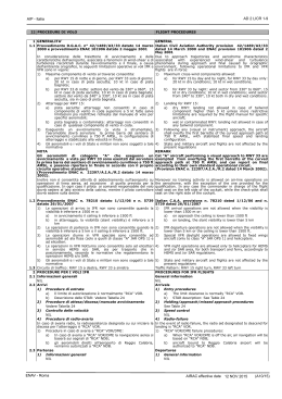
Scarica