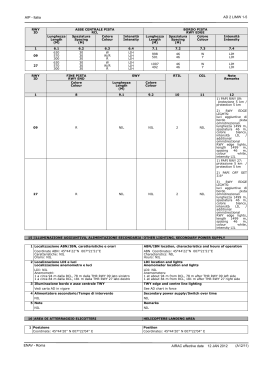
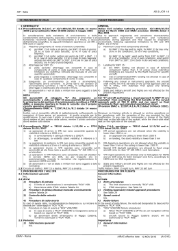
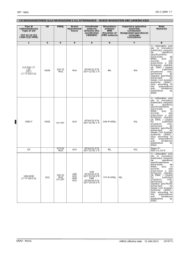
AD 2 LICA 1-1
AIP - Italia
1 LICA
Indicatore di località
Location indicator
LAMEZIA TERME
Nome dell’ Aeroporto
Aerodrome name
2 DATI AMMINISTRATIVI E GEOGRAFICI DELL’AEROPORTO
AERODROME GEOGRAPHICAL AND ADMINISTRATIVE DATA
1 Coordinate ARP
38°54'30''N 016°14'30''E
2 Direzione e distanza dalla città
1 NM S
3 Elevazione/Temperatura di riferimento
39 FT / 28.6 °C
4 Ondulazione del geoide
139.7 FT
5 Variazione magnetica/Variazione annuale
3° E (2010.0) / 4'E
6 Autorità amministrativa aeroportuale
ENAC - DA Calabria
Aeroporto di Lamezia Terme
88040 Lamezia Terme (Catanzaro)
tel +39 0968 414111/345/309 fax +39 0968 414360
e-mail: [email protected]
ARP coordinates
38°54'30''N 016°14'30''E
Direction and distance from city
1 NM S
Elevation/Reference temperature
39 FT / 28.6 °C
Geoid undulation
139.7 FT
Magnetic variation/Annual change
3° E (2010.0) / 4'E
Aerodrome administration authority
ENAC - DA Calabria
Aeroporto di Lamezia Terme
88040 Lamezia Terme (Catanzaro)
tel +39 0968 414111/345/309 fax +39 0968 414360
e-mail: [email protected]
Esercente
Aerodrome operator
S.A.C.A.L. S.p.A.
S.A.C.A.L. S.p.A.
Ufficio Controllo Voli tel +39 0968 414438 fax +39 0968 414442 Flight Control Office tel +39 0968 414438 fax +39 0968 414442
(H24)
(H24)
88040 Aeroporto Lamezia Terme (Catanzaro)
88040 Aeroporto Lamezia Terme (Catanzaro)
Autorità ATS
ENAV S.p.A.
Centro Aeroportuale Lamezia Terme
Tel: +39 0968 410030; fax: +39 0968 53489
e-mail: [email protected]
7 Tipo di traffico consentito (IFR/VFR)
IFR/VFR
8 Note
1)
Codice di riferimento ANNESSO 14 per infrastrutture di volo: 4D
2)
ARP 350 m verso N da asse pista
3 ORARIO DI SERVIZIO
1 Amministrazione aeroportuale
H24
2 Dogana e immigrazione
0600-2400 (0500-2300) tutti i giorni. Fuori orario a richiesta (tel
+39 0968 411205)
3 Servizio sanitario
H24
4 AIS Briefing Office
H24 ARO CBO ROMA
5 ARO
H24 ARO CBO ROMA
6 METEO Briefing Office
H24 ARO CBO ROMA
7 ATS
H24
8 Rifornimento
Carboil Fuel Company:
JET A1: 0600-2200 (0500-2100). Altri orari a richiesta chiamando
2 HR PN tel +39 0968 53166, fax +39 0968 419703, cell +39 393
1240965, +39 333 2183733
9 Handling
S.A.C.A.L. H24, 2330-0500 (2230-0400) servizio handling
disponibile solo con PPR da inviare prima delle 1900 (1800). PPR
non richiesto per voli di Stato, umanitari, ambulanza, trasporto
organi e postali.
AVIAPARTNER 0530-2300 (0430-2200). Altri orari su richiesta
10 Servizi di sicurezza
H24
11 De-icing
NIL
ENAV - Roma
ATS authority
ENAV S.p.A.
Centro Aeroportuale Lamezia Terme
Tel: +39 0968 410030; fax: +39 0968 53489
e-mail: [email protected]
Type of traffic permitted (IFR/VFR)
IFR/VFR
Remarks
1)
Reference code ANNEX 14 flight infrastructure: 4D
2)
ARP 350 m N direction from RCL
OPERATIONAL HOURS
Aerodrome Administration
H24
Customs and immigration
0600-2400 (0500-2300) every day. Other hours on request (tel +39
0968 411205)
Health and sanitation
H24
AIS Briefing Office
H24 ARO CBO ROMA
ARO
H24 ARO CBO ROMA
METEO Briefing Office
H24 ARO CBO ROMA
ATS
H24
Fuelling
Carboil Fuel Company:
JET A1: 0600-2200 (0500-2100). Other hours on request calling
with 2 HR PN tel +39 0968 53166, fax +39 0968 419703, mobile
+39 393 1240965, +39 333 2183733
Handling
S.A.C.A.L. H24, 2330-0500 (2230-0400) handling service available
only with PPR before 1900 (1800). PPR not requested for State,
humanitarian, ambulance, organ transport and postal flight.
AVIAPARTNER 0530-2300 (0430-2200). Other hours on request
Security
H24
De-icing
NIL
AIRAC effective date
07 JAN 2016
(A12/15)
AD 2 LICA 1-2
AIP - Italia
12 Note
1)
Handling:
a)
S.A.C.A.L. Handling
Ufficio Operazioni:
tel: +39 0968 414329/424 fax +39 0968 414404
e-mail: [email protected]
SITA: SUFKOXH
b)
AVIAPARTNER Handling
Ufficio Operazioni:
tel: +39 0968 419430
fax: +39 0968 418629
cell: +39 345 0689943
e-mail: [email protected]
SITA: SUFAOXH
2)
ARO CBO ROMA: vedi GEN 3.1
4 SERVIZI DI SUPPORTO ED ATTREZZATURE
Remarks
1)
Handling:
a)
S.A.C.A.L. Handling
Operational office:
tel: +39 0968 414329/424 fax +39 0968 414404
e-mail: [email protected]
SITA: SUFKOXH
b)
AVIAPARTNER Handling
Operational office:
tel: +39 0968 419430
fax: +39 0968 418629
mobile: +39 345 0689943
e-mail: [email protected]
SITA: SUFAOXH
2)
ARO CBO ROMA: see GEN 3.1
HANDLING SERVICES AND FACILITIES
1 Attrezzatura di carico e scarico merci
Nastro trasportatore - Scale - Elevatori - Carrelli - Trattori - Loader Fork lift
2 Tipi di carburante/Olio
JET A1 / NIL
3 Capacità di rifornimento
Kerosene JET A1: autobotti 4X40000 litri, capacità totale 270000 litri
4
5
6
7
Cargo-handling facilities
Conveyor belt - Ladders - Elevators - Trolleys - Tractors - Loader Fork lift
Fuel/Oil types
JET A1 / NIL
Fuelling capacity
Kerosene JET A1: tank-trucks 4X40000 litres, total capacity 270000
litres
Sistema de-icing
De-icing facilities
NIL
NIL
Hangar per aeromobili in transito
Hangar space for visiting aircraft
NIL
NIL
Servizio riparazioni per aeromobili in transito
Repair facilities for visiting aircraft
NIL
NIL
Note
Remarks
1)
Il servizio di handling ai voli di linea, charter e dell’aviazione 1)
Handling service to scheduled, charter and general aviation
generale è fornito da Sacal Handling, sulla frequenza 131.455
flights is provided by Sacal Handling, on frequency 131.455
MHz
MHz
5 SERVIZI PER I PASSEGGERI
PASSENGER FACILITIES
1 Alberghi
Hotels
Alberghi in città
Hotel in Lamezia town
2 Ristoranti
Restaurants
In aerostazione
In aerodrome
3 Trasporti
Transportation
Bus - taxi
Bus - taxi
4 Servizio medico
Medical facilities
Pronto soccorso - Medici - Paramedici - 2 Ambulanze - Ospedale in First aid treatment - Doctors - Nurses - 2 Ambulances - Hospital in
città a 6 km
town 6 km
5 Banca e ufficio postale
Bank and Post office
Sportello bancomat - Ufficio Postale: NIL
Cashpoint - Post Office: NIL
6 Ufficio turistico
Tourist office
Assessorato Regionale al Turismo
Assessorato Regionale al Turismo
7 Note
Remarks
NIL
NIL
6 SERVIZI ANTINCENDIO E DI SOCCORSO
RESCUE AND FIRE FIGHTING SERVICES
1 Categoria servizio antincendio aeroportuale
CAT 7 ICAO
2 Equipaggiamento per il soccorso
NIL
3 Rimozione aeromobili in difficoltà
Servizio di sollevamento e rimozione
4 Note
1)
Categoria servizio antincendio aeroportuale: CAT 8 ICAO O/R
Aerodrome category for fire fighting
CAT 7 ICAO
Rescue equipment
NIL
Capability for removal of disabled aircraft
Lift and tow service supplied
Remarks
1)
Aerodrome category for fire fighting: CAT 8 ICAO O/R
7 DISPONIBILITA’
PISTE
STAGIONALE
E
SISTEMI
DI
PULITURA SEASONAL AVAILABILITY AND CLEARING
1 Equipaggiamenti di pulitura
Autospazzatrice
2 Priorità
NIL
3 Note
1)
La misurazione del coefficiente di aderenza della pista è
determinato mediante il Grip Tester. Coefficiente minimo di
attrito: 0,43 a 65 km/h
AIRAC effective date
07 JAN 2016 (A12/15)
Types of clearing equipment
Sweeper
Clearance priorities
NIL
Remarks
1)
RWY friction coefficient measured by Grip Tester. Minimum
friction coefficient: 0,43 at 65 km/h
ENAV - Roma
AD 2 LICA 1-3
AIP - Italia
8 DATI RELATIVI AI PIAZZALI, ALLE VIE DI RULLAGGIO ED APRONS, TAXIWAYS AND CHECK LOCATIONS DATA
ALLE PIAZZOLE PROVA
1 Superficie e resistenza dell’area di stazionamento
Apron
Superficie: ASPH 124000 mq
Resistenza: PCN 58/F/B/W/T
Apron
Surface: ASPH 124000 sqm
Strength: PCN 58/F/B/W/T
2 Larghezza, superficie e resistenza delle TWY
A
Larghezza: 24 M
Superficie: Conglomerato bituminoso
Resistenza: PCN 58/F/B/W/T
B
Larghezza: 24 M
Superficie: Conglomerato bituminoso
Resistenza: PCN 58/F/B/W/T
C
Larghezza: 24 M
Superficie: Conglomerato bituminoso
Resistenza: PCN 58/F/B/W/T
D
Larghezza: 24 M
Superficie: Conglomerato bituminoso
Resistenza: PCN 58/F/B/W/T
E
Larghezza: 18 M
Superficie: CONC
Resistenza: NIL
F
Larghezza: 34 M
Superficie: Conglomerato bituminoso
Resistenza: PCN 58/F/B/W/T
G
Larghezza: 34 M
Superficie: Conglomerato bituminoso
Resistenza: PCN 58/F/B/W/T
H
Larghezza: 34 M
Superficie: Conglomerato bituminoso
Resistenza: PCN 58/F/B/W/T
J
Larghezza: 28 M
Superficie: Conglomerato bituminoso
Resistenza: PCN 58/F/B/W/T
S
Larghezza: 30 M
Superficie: Conglomerato bituminoso
Resistenza: PCN 58/F/B/W/T
TWY width, surface and strength
A
Width: 24 M
Surface: Bituminous conglomerate
Strength: PCN 58/F/B/W/T
B
Width: 24 M
Surface: Bituminous conglomerate
Strength: PCN 58/F/B/W/T
C
Width: 24 M
Surface: Bituminous conglomerate
Strength: PCN 58/F/B/W/T
D
Width: 24 M
Surface: Bituminous conglomerate
Strength: PCN 58/F/B/W/T
E
Width: 18 M
Surface: CONC
Strength: NIL
F
Width: 34 M
Surface: Bituminous conglomerate
Strength: PCN 58/F/B/W/T
G
Width: 34 M
Surface: Bituminous conglomerate
Strength: PCN 58/F/B/W/T
H
Width: 34 M
Surface: Bituminous conglomerate
Strength: PCN 58/F/B/W/T
J
Width: 28 M
Surface: Bituminous conglomerate
Strength: PCN 58/F/B/W/T
S
Width: 30 M
Surface: Bituminous conglomerate
Strength: PCN 58/F/B/W/T
3 Localizzazione/Elevazione ACL
ACL location/Elevation
NIL
NIL
4 Punto di controllo VOR/INS
VOR/INS checkpoints
NIL / NIL
NIL / NIL
5 Note
1)
Apron surface and strength
Remarks
TWY E: larghezza 18 m, superficie in calcestruzzo, per uso 1)
esclusivamente militare
TWY E: width 18 m, surface concrete, exclusively for military
use
9 GUIDA AI MOVIMENTI A TERRA E SISTEMI DI CONTROLLO E SURFACE MOVEMENT GUIDANCE AND CONTROL SYSTEM AND
SEGNALAZIONE
MARKINGS
1 Segnale di identificazione stand aeromobili, linee guida per
TWY e sistemi di guida per parcheggio a vista negli stand
degli aeromobili
Vedi carta APD in vigore
2 Illuminazione e segnaletica per RWY e TWY
Le vie di rullaggio sono provviste di segnaletica ICAO diurna e
notturna
RGL disponibili vedi carta AD in vigore
3 Barre d’arresto
Vedi carta AD in vigore
4 Note
NIL
10 OSTACOLI AEROPORTUALI
Use of aircraft stand identification sign, TWY guide lines and
visual docking/parking guidance system of aircraft stands
See APD chart in force
RWY and TWY markings and lights
Taxiways provided with ICAO day and night signalling
RGL available see AD chart in force
Stop bars
See AD chart in force
Remarks
NIL
AERODROME OBSTACLES
Nelle aree di avvicinamento e decollo
In approach and take off areas
RWY e Area
interessata
RWY and Area
affected
a
ENAV - Roma
1
Tipo di ostacolo
Elevazione
Segnaletica e Luci
Obstacle type
Elevation
Markings and Lights
b
Nell’area di circuitazione e all’interno
dell’aerodromo
In circling area and at aerodrome
2
Coordinate
Tipo di ostacolo
Coordinate
Coordinates
Elevazione
Coordinates
Segnaletica e Luci
Obstacle type
Elevation
Marking and Lights
c
a
b
Vedi AOC in vigore - See AOC in force
AIRAC effective date
Note
Remarks
07 JAN 2016
3
(A12/15)
AD 2 LICA 1-4
AIP - Italia
11 INFORMAZIONI METEOROLOGICHE
METEOROLOGICAL INFORMATION
1 Ufficio METEO associato
UPM ROMA
2 Orario di servizio
H24
3 Ufficio responsabile preparazione TAF/Periodo di validità
UPM ROMA / 24H
4 Tipo di previsione per l’atterraggio/Intervallo di emissione
NIL / NIL
5 Briefing e consultazione fornita
Briefing: ARO CBO ROMA, telefono
Consultazione: UPM ROMA, telefono
6 Documentazione di volo/Lingua usata
Carte, testi in linguaggio chiaro abbreviato
IT, EN
7 Carte e documentazione disponibili per consultazione
Fax
9 Enti ATS destinatari delle informazioni
Lamezia TWR, Lamezia APP
10 Informazioni climatologiche e informazioni supplementari
1)
ARO CBO ROMA: vedi GEN 3.1
2)
UPM ROMA: vedi GEN 3.5
3)
Aeroporto occasionalmente interessato da fenomeni di wind
shear orografico, più frequenti nei mesi invernali, in prevalenza
associati a venti al suolo da 330-60° o 270-300° di intensità
10-15 kt e da NE di intensità maggiore di 20 kt alla quota di
1500 m
Associated MET Office
UPM ROMA
Hours of service
H24
Office responsible for TAF preparation/Period of validity
UPM ROMA / 24H
Type of landing forecast/Interval of issuance
NIL / NIL
Briefing and consultation provided
Briefing: ARO CBO ROMA, telephone
Consultation: UPM ROMA, telephone
Flight documentation/Language used
Charts, abbreviated plain language texts
IT, EN
Charts and other information available for briefing or
consultation
P, W, SWL
Supplementary
equipment
available
for
providing
information
Fax
ATS units provided with information
Lamezia TWR, Lamezia APP
Climatological information and additional information
1)
ARO CBO ROMA: see GEN 3.1
2)
UPM ROMA: see GEN 3.5
3)
Aerodrome occasionally affected by terrain-induced wind shear
phenomena, more frequently occurring in winter, mostly
originated by winds having a 330-60° or a 270-300° direction
and a 10-15 kt intensity at ground level and a NE direction and
a higher than 20 kt intensity at 1500 m
12 CARATTERISTICHE FISICHE DELLE PISTE
RUNWAY PHYSICAL CHARACTERISTICS
P, W, SWL
8 Mezzi aggiuntivi disponibili per l’informazione
Designazione
NR RWY
Designation
QFU
Dimensioni RWY
Dimension of RWY
(M)
Resistenza e superficie di
RWY
Strength and surface of
RWY
1
2
3
4
10
096°
2416 x 45
PCN 58/F/B/W/T
ASPH
28
276°
2416 x 45
PCN 58/F/B/W/T
ASPH
Designazione
NR RWY
Designation
1
Pendenza di
RWY-SWY
Slope
7
Longitudinale /
longitudinal: 0,254%
Trasversale / trasversal:
NIL
Longitudinale /
longitudinal: 0,254%
Trasversale / trasversal:
NIL
10
28
Designazione
NR RWY
Designation
1
10
28
AIRAC effective date
THR ELEV, MAX TDZ ELEV
della RWY per APCH di
precisione
THR ELEV, MAX TDZ ELEV
of precision APCH RWY
6
19.9 FT / 25.7 FT
39.3 FT / 39.3 FT
Dimensioni SWY
SWY dimension
(M)
8
Dimensioni CWY
CWY dimension
(M)
9
Dimensioni strip
strip dimension
(M)
10
Dimensioni RESA
RESA dimension
(M)
11
NIL
210 x 150
2536 x 300
90 x 90
NIL
60 x 300
2536 x 300
90 x 90
OFZ
Obstacle free zone (OFZ)
12
NIL
Non applicabile
Not applicable
Coordinate THR
THR coordinates
--Coordinate RWY END
RWY END Coordinates
--Ondulazione Geoide THR
THR Geoid Undulation
5
38°54'24.71''N
016°13'46.95''E
----------------------------38°54'13.65''N
016°15'21.74''E
----------------------------140.1 FT
38°54'14.15''N
016°15'17.39''E
----------------------------38°54'25.22''N
016°13'42.59''E
----------------------------139.7 FT
Note
Remarks
13
1) DTHR 107 m
1) DTHR 107 m
07 JAN 2016 (A12/15)
ENAV - Roma
AD 2 LICA 1-5
AIP - Italia
13 DISTANZE DICHIARATE
DECLARED DISTANCES
Designazione RWY
RWY designator
1
10
INT TAKE-OFF C
28
INT TAKE-OFF B
NOTE/REMARKS
TORA
(M)
2
2416
1520
2416
1520
1)
TODA
(M)
3
2626
1730
2476
1580
Tipo
Type
APPROACH AND RUNWAY LIGHTING
AVVICINAMENTO
APPROACH
Lunghezza
Intensità
Length
Intensity
(M)
THR
VASIS
2.2
2.3
3
4.1
10
NIL
NIL
NIL
G
NIL
28
CAT I
900
LIH
G
NIL
Lunghezza
Length
(M)
Intensità
Intensity
Lunghezza
Length
(M)
7.1
100
1700
600
100
1700
600
1
6.1
6.2
6.3
6.4
10
NIL
NIL
NIL
NIL
28
NIL
NIL
NIL
NIL
RWY
ID
FINE PISTA
RWY END
Colore
Colour
1
10
28
4.2
3°
wing bars
entrambi i lati
both sides
3°
wing bars
entrambi i lati
both sides
TDZ
Lunghezza
Length
(M)
Colore
Colour
9.1
NIL
NIL
9.2
NIL
NIL
4.3
5
16.0
NIL
16.0
NIL
BORDO PISTA
RWY EDGE
Spaziatura
Colore
Spacing
Colour
(M)
SWY
8
R
R
MEHT
(M)
Lunghezza
Length
(M)
2.1
ASSE CENTRALE PISTA
RCL
Spaziatura
Colore
Spacing
Colour
(M)
PAPI
Colore
Colour
1
RWY
ID
LDA
(M)
5
2309
2309
-
Gli Intersection Take-off sono utilizzabili soltanto su richiesta del pilota o su richiesta della TWR previo
benestare del pilota/Intersection Take-off are usable only on pilot’s request or on TWR’s request, previous
pilot’s agreement
14 LUCI DI AVVICINAMENTO E LUCI PISTA
RWY
ID
ASDA
(M)
4
2416
1520
2416
1520
Intensità
Intensity
7.2
60
60
60
60
60
60
7.3
R
W
Y
R
W
Y
7.4
LIH
LIH
LIH
LIH
LIH
LIH
RTIL
CGL
Note
Remarks
10
2
2
11
NIL
NIL
12
NIL
NIL
15 ILLUMINAZIONE AGGIUNTIVA, ALIMENTAZIONE SECONDARIA OTHER LIGHTING, SECONDARY POWER SUPPLY
1 Localizzazione ABN/IBN, caratteristiche e orari
ABN installato sopra la TWR
Caratteristiche: ABN rotante con luci alternate bianco/verde
Orario: come le altre luci di aerodromo
2 Localizzazione LDI e luci
Localizzazione anemometro e luci
LDI: NIL
Anemometri:
1) 506 m dopo THR 28, 136 m lato sinistro RCL
2) 400 m dopo THR 28, 165 m lato sinistro RCL
3 Illuminazione bordo e asse centrale TWY
Bordo: luci azzurre - Asse centrale: NIL - Vedi Carta AD in vigore
4 Alimentatore secondario/Tempo di intervento
GECA/0 secondi
5 Note
1)
ABN/IBN location, characteristics and hours of operation
ABN installed on the TWR
Characteristics: ABN revolving white/green alternate lights
Hours of operation: as other aerodrome lights
LDI location and lights
Anemometer location and lights
LDI: NIL
Anemometers:
1) 506 m after THR 28, 136 m left side RCL
2) 400 m after THR 28, 165 m left side RCL
TWY edge and centre line lighting
Edge: blue - Centerline: NIL - See AD chart in force
Secondary power supply/Switch over time
GECA/0 seconds
Remarks
L’intensità delle assistenze luminose è regolabile su richiesta del 1)
pilota
16 AREA DI ATTERRAGGIO ELICOTTERI
1 Posizione
NIL
2 Elevazione
NIL
3 Dimensioni, superficie, resistenza, segnaletica
NIL
ENAV - Roma
The lighting aids’ intensity is adjustable on pilot’s request
HELICOPTERS LANDING AREA
Position
NIL
Elevation
NIL
Dimensions, surface, strength, marking
NIL
AIRAC effective date
07 JAN 2016
(A12/15)
AD 2 LICA 1-6
AIP - Italia
4 Orientamento
NIL
5 Distanze dichiarate
NIL
6 Luci
NIL
7 Note
NIL
Bearing
NIL
Declared distances
NIL
Lighting
NIL
Remarks
NIL
17 SPAZIO AEREO ATS
ATS AIRSPACE
Designatore e limiti laterali
Designation and lateral limits
Limiti
verticali
Vertical
limits
Classificazione dello
spazio aereo
Airspace
classification
1
Lamezia Terme ATZ
Cerchio di raggio/Circle of radius 5.0
NM
centrato su/centred on:
38°54'17''N 016°14'30''E
2
3
2000 FT
AGL
D
Frequenza MHZ
Frequency MHZ
3
Orario
Operational hours
4
NIL
121.500 MHZ
H24
NIL
H24
H24
0800-1700 (0700-1600)
0800-1700 (0700-1600)
H24
H24
NIL
NIL
NIL
NIL
NIL
NIL
Lamezia APP
118.800
122.100
118.800
122.100
122.100
125.900
Lamezia TWR
MHZ
MHZ
MHZ
MHZ
MHZ
MHZ
FREQ
Orario
Operational
hours
Coordinate
antenna
Antenna site
coordinates
(WGS84)
Elevazione
antenna
DME
Elevation of
DME antenna
2
3
4
5
6
Lamezia
Gonio
Homer
NIL
H24
38°54'32.9''N
016°13'39.6''E
CDC
117.30
MHZ
CH 120X
VOR
H24
TACAN
H24
VOR
38°45'21.1''N
016°22'08.9''E
TACAN
38°45'21.1''N
016°22'08.9''E
VOR/DME
(3° E-2010.0)
CRN
117.10
MHZ
CH 118X
VOR
H24
DME
H24
ILS RWY 28
LOC
CAT I
(3° E-2010.0)
LAM
110.30
MHZ
H24
VDF
VORTAC
(3° E-2010.0)
DME-P
AIRAC effective date
LAM
6
1) WI Lamezia CTR
CH 40X
07 JAN 2016 (A12/15)
H24
Note
Remarks
5
RADIO NAVIGATION AND LANDING AIDS
ID
CAT di/of ILS
(VAR ILS/VOR)
1
5
6000 FT
Nominativo
Call sign
2
19 RADIOASSISTENZE ALLA NAVIGAZIONE E ALL’ATTERRAGGIO
Tipo di
radioassistenza
Type of aid
Note
Remarks
ATS COMMUNICATION FACILITIES
Lamezia Radar
TWR
Altitudine di
transizione
Transition
altitude
Lamezia TWR
EN / IT
18 SERVIZI DI COMUNICAZIONE ATS
Servizio
Service
1
Emergenza
Emergency
APP
Nominativo
dell’unità ATS
Lingua
ATS unit call sign
Language
4
NIL
Copertura operativa
nominale
Limitazioni
Designated operational
coverage
Limitations
Note
Remarks
7
8
limitazioni
15 NM
356°/015°
limitazioni
23 NM
016°/110°
111°/180°
181°/250°
251°/320°
321°/355°
a/limitations
at
1) Disponibile su
richiesta su tutte le
at frequenze di TWR
ed emergenza /
MRA 10000 FT
Available
on
MRA 8000 FT
request on all TWR
MRA 4000 FT
and
emergency
MRA 2000 FT
frequencies
MRA 10000 FT
MRA 8000 FT
a/limitations
998 M AMSL
200 NM/60000 FT
limitazioni a/limitations
40 NM
060°/150° MRA 4500 FT
150°/220° MRA 9500 FT
220°/330° MRA 4500 FT
330°/060° MRA 7500 FT
VOR
38°59'46.0''N
017°04'59.0''E
DME
38°59'46.0''N
017°04'59.4''E
167 M AMSL
150 NM/60000 FT
limitazioni a/limitations at 1) MAINT:
Primo MON di ogni
40 NM
mese / first MON
120°/270° MRA 6000 FT
each month: 0800270°/350° MRA 10000 FT
0900 (0700-0800)
350°/120° MRA 3000 FT
38°54'26.3''N
016°13'33.5''E
NIL
1) Fascio posteriore
limitazioni oltre/limitations non
utilizzabile/
beyond 17 NM MRA 5000 FT back
beam
not
usable
16 M AMSL
1)Funzionalità Final
25 NM/10000 FT
approach
non
limitazioni a/limitations at utilizzabile.
Per
25 NM
maggiori
090°/220° MRA 12000 FT
informazioni
vedi
220°/240° MRA 8000 FT
GEN
3.4/Final
240°/310° MRA 1500 FT
approach mode not
310°/330° MRA 12000 FT
usable. For more
330°/340° MRA 15000 FT
information
see
340°/090° MRA 18000 FT
GEN 3.4
38°54'10.5''N
016°15'02.7''E
at
1) MAINT:
Primo e terzo FRI di
ogni mese / first
and third FRI each
month: 0700-0900
(0600-0800)
ENAV - Roma
AD 2 LICA 1-7
AIP - Italia
Tipo di
radioassistenza
Type of aid
ID
FREQ
Orario
Operational
hours
Coordinate
antenna
Antenna site
coordinates
(WGS84)
Elevazione
antenna
DME
Elevation of
DME antenna
Copertura operativa
nominale
Limitazioni
Designated operational
coverage
Limitations
2
3
4
5
6
7
CAT di/of ILS
(VAR ILS/VOR)
1
GP
MM
DVOR/DME
(3° E-2010.0)
DVOR/DME
(2° E-2010.0)
-
-
LMT
RCA
335.00
MHZ
H24
75.00
MHZ
H24
112.50
MHZ
CH 72X
111.00
MHZ
CH 47X
38°54'11.1''N
016°15'02.9''E
NIL
38°54'09.7''N
016°15'55.6''E
NIL
DVOR
H24
DME
H24
DVOR
38°54'16.0''N
016°15'56.0''E
DME
38°54'16.4''N
016°15'56.1''E
DVOR
H24
DME
H24
DVOR
38°04'35.7''N
015°38'43.0''E
DME
38°04'35.7''N
015°38'42.5''E
20 REGOLAMENTI DEL TRAFFICO LOCALE
1 Uso preferenziale delle piste
NIL
2 Apron
Pianificazione stand ed assegnazione di contatto (Ufficio Controllo
Volo): SACAL/UCV
HR: H24
Tel.: +39 0968 414441 Fax: +39 0968 414442
e-mail: [email protected]
3 Norme per l’utilizzo delle vie di rullaggio
1)
Il rullaggio sulla TWY J è consentito ad aeromobili con apertura
alare massima di 52 m
2)
TWY E ad esclusivo uso militare
4 Procedure speciali applicabili agli aeromobili in condizioni di
bassa visibilità
Operazioni in condizioni di bassa visibilità:
1)
le operazioni di avvicinamento per l’atterraggio ILS CAT I sono
consentite solo per RWY 28 in condizioni di visibilità generale non
inferiori a 800 m e DH maggiore o uguale alla OCH pubblicata
2)
le operazioni di decollo sono consentite in condizioni di visibilità
generale non inferiore a 400 m
3)
la circolazione al suolo degli aeromobili è limitata ad un
movimento al suolo per volta in condizioni di visibilità generale
uguali o inferiori a 1200 m di giorno e di notte. L’assistenza del
FOLLOW-ME sarà fornita su richiesta del pilota
5 Operazioni per l’utilizzo della pista nel tempo strettamente
necessario
NIL
6 Restrizioni locali ai voli
Limitazioni per vento:
Per ogni tipo di aeromobile dovrà essere applicata una riduzione del
15% alla massima componente dimostrata di vento al traverso
pubblicata sull’AFM (Aircraft Flight Manual) con pista asciutta e una
riduzione del 25% con pista bagnata
7 Disposizioni per gli aeromobili dell’aviazione generale
Tutti gli aeromobili dell’Aviazione Generale diretti a Lamezia Terme,
prima di lasciare l’aeroporto di origine, devono ottenere
l’autorizzazione da SACAL/UCV (H24, tel. +39 0968 414441, fax +39
0968 414442, e-mail [email protected]).
Le richieste devono includere: dati dell’operatore, contatti per
comunicazioni, numero dell’aeromobile, tipo di aeromobile, ETA e
durata della sosta.
Ogni eventuale estensione della “stand clearance” e/o ritardo, devono
essere precedentemente autorizzati da SACAL/UCV, deve essere
fornita anche la comunicazione della eventuale cancellazione del volo.
Il numero di autorizzazione rilasciato da SACAL/UCV deve essere
inserito nel punto 18 del piano di volo.
Tutti gli aeromobili dell’Aviazione Generale diretti a Lamezia Terme,
prima di lasciare l’aeroporto di origine, devono contattare SACAL/UCV
per ottenere i servizi di movimentazione a terra
8
1) GP COV:
ridotta a/reduced at
8 NM
NIL
Slope 3°
RDH:16.13 M
NIL
NIL
24 M AMSL
25 NM/25000 FT
limitazioni a/limitations at
25 NM
100°/180° MRA 8000 FT
NIL
180°/230° MRA 4000 FT
230°/300° MRA 2000 FT
300°/100° MRA 12000 FT
26 M AMSL
Settore/sector
000°/315°:
40 NM/25000 FT
Settore/sector
315°/360°:
80 NM/25000 FT
limitazioni a/limitations at
25 NM
060°/170° MRA 15000 FT
170°/230° MRA 5000 FT
230°/060° MRA 9000 FT
1) MAINT:
Primo THU di ogni
mese/first
THU
each month: 13001600 (1200-1500)
LOCAL TRAFFIC REGULATIONS
Runway preferential use
NIL
Apron
Stand planning and allocation contact (Flight Control Office):
SACAL/UCV
HR: H24
Tel.: +39 0968 414441 Fax: +39 0968 414442
e-mail: [email protected]
Special rules for taxiway use
1)
Taxiing on TWY J allowed to aircraft with MAX wing span 52 m
2)
TWY E exclusively for military use
Aircraft special procedures in low visibility conditions
Low visibility operations:
1)
ILS CAT I approach for landing operations allowed only for
RWY 28 under conditions of general visibility not below 800 m
and DH greater or equal to published OCH
2)
take off operations allowed under conditions of general
visibility not below 400 m
3)
taxiing operations reduced to one aircraft at a time under
conditions of general visibility equal to or lower than 1200 m
during day or night. FOLLOW-ME service available on pilot’s
request
Special operational practice for minimum RWY occupancy
NIL
Local flight restrictions
Wind limitations:
A 15% reduction from maximum demonstrated crosswind
component published on the AFM (Aircraft Flight Manual) shall be
applied for each type of aircraft with RWY dry, 25% reduction with
RWY wet
Provisions for general aviation aircraft
All General Aviation aircraft going to Lamezia Terme, before leaving
from the airport of origin, must obtain authorization by SACAL/UCV
(H24, tel. +39 0968 414441, fax +39 0968 414442, e-mail
[email protected]).
Applications must include: operator data, contacts for
communications, aircraft registration, aircraft type, ETA and
stopover duration.
Any eventual extension of the stand clearance and/or delay, must
be previously authorized by SACAL/UCV, communication must be
given also in case of flight cancellation. Authorization number
issued by SACAL/UCV has to be inserted in item 18 of PLN.
All General aviation aircraft going to Lamezia Terme must contact
SACAL/UCV before leaving from the airport of origin, in order to
have ground handling services
21 PROCEDURE ANTIRUMORE
NOISE ABATEMENT PROCEDURES
1 Generalità
NIL
General
NIL
ENAV - Roma
Note
Remarks
AIRAC effective date
07 JAN 2016
(A12/15)
AD 2 LICA 1-8
AIP - Italia
2 Uso delle piste
1) Partenze
NIL
2) Arrivi
NIL
3) Restrizioni notturne
NIL
3 Restrizioni al suolo
1) Spinta inversa
NIL
2) APU
NIL
3) Prove Motori
NIL
4 Attività addestrativa
NIL
22 PROCEDURE DI VOLO
1 GENERALITA’
Il circuito di traffico aeroportuale deve essere sempre eseguito a Sud
della pista, qualunque sia la pista in uso
2 PROCEDURE PER I VOLI IFR
2.1 Informazioni generali
NIL
2.2 Arrivi
1) Procedure di entrata
Descrizione delle STAR
Vedi tabella 24
2) Procedure di attesa/discesa/mancato avvicinamento
Vedi tabella 24
3) Controllo delle velocità
NIL
4) Procedure di radio-avaria
In caso di radioavaria la radioassistenza designata su cui iniziare
la discesa per l'atterraggio è “LMT” VOR/DME
Procedure in caso di avaria di "LMT" VOR/DME
a)
Tutte le rotte di entrata standard vengono attestate su
“CDC” VORTAC
b)
Durante la procedura di salita iniziale le rotte da seguire
fino all'inizio delle virate, a seconda della SID assegnata,
sono 275° (RWY 28) e 096° (RWY 10)
2.3 Partenze
1) Informazioni generali
Se non diversamente indicato, tutte le virate, eseguite entro 20
NM dal decollo, non debbono superare le 2.5 NM di raggio.
A tal fine si suggerisce:
- TAS non superiore a 250 kt
- Angolo di banco 25° oppure, rateo di virata non inferiore a 2°/
secondo, quale delle due misure comporta un banco inferiore.
I piloti devono adottare un gradiente minimo di salita conforme
alle prescrizioni dell’Annesso 6 ICAO per un sicuro sorvolo degli
ostacoli. Tale gradiente deve essere mantenuto in ogni
circostanza prevedibile
2) Procedure per la messa in moto
NIL
3) Procedure di uscita
Procedure di salita iniziale e SID
Vedi tabella 24
4) Controllo delle velocità
NIL
3 PROCEDURE RADAR
3.1 Informazioni generali
NIL
3.2 Caratteristiche operative
1) Uso del radar nel Servizio di Controllo di Aerodromo
NIL
2) Uso del radar per i movimenti di superficie (SMR)
NIL
3.3 Caratteristiche tecniche
NIL
3.4 Radar avaria
NIL
4 PROCEDURE PER I VOLI VFR
4.1 Informazioni generali
NIL
4.2 Attività di circuito
Vedi Tabella 22.1
4.3 Arrivi
NIL
4.4 Partenze
NIL
AIRAC effective date
07 JAN 2016 (A12/15)
Use of RWY
1) Departures
NIL
2) Arrivals
NIL
3) Night restrictions
NIL
Ground restrictions
1) Reverse
NIL
2) APU
NIL
3) Engine run ups
NIL
Training activity
NIL
FLIGHT PROCEDURES
GENERAL
Aerodrome traffic pattern shall be executed South of runway
whichever is the runway in use
PROCEDURES FOR IFR FLIGHTS
General information
NIL
Arrivals
1) Entry procedures
STAR description
See table 24
2) Holding/approach/missed approach procedures
See table 24
3) Speed control
NIL
4) Radio-failure
In the event of radio failure, the radio aid designated to
descend for landing is “LMT” VOR/DME
Procedures in case of "LMT" VOR/DME failure
a)
All standard entry routes are based on “CDC” VORTAC
b)
During initial climb procedure, the tracks to be followed
until turning, according to the assigned SID, are 275°
(RWY 28) and 096° (RWY 10)
Departures
1) General information
Except when otherwise prescribed, all turns, executed within
20NM from take off, shall not exceed a radius of 2.5 NM.
To meet said requirement, it is suggested:
- TAS not more then 250 kt
- Bank angle 25° or, rate of turn not less than 2° per second,
whichever requires the lesser bank.
Pilots shall adopt a minimum climb gradient in accordance
with ICAO Annex 6 provision for a safe obstacles overflying.
Such climb gradient shall be maintained in any forseeable
circumstance
2) Start-up procedures
NIL
3) Exit procedures
Initial Climb procedures and SID
See table 24
4) Speed control
NIL
RADAR PROCEDURES
General information
NIL
Operational characteristics
1) Use of radar in Aerodrome Control Service
NIL
2) Use of radar for surface movements (SMR)
NIL
Technical characteristics
NIL
Radar failure
NIL
PROCEDURES FOR VFR FLIGHTS
General information
NIL
Circuit activity
See Table 22.1
Arrivals
NIL
Departures
NIL
ENAV - Roma
AD 2 LICA 1-9
AIP - Italia
4.5 Sorvoli
NIL
4.6 VFR Speciale
NIL
4.7 VFR notturno
1)
Il VFR notturno è consentito in accordo alla regolamentazione
pubblicata in AIP ENR 1.2
2)
Il circuito di traffico per il VFR notturno è solo a sud della RWY,
come segue:
RWY 10 virata a destra
RWY 28 virata a sinistra
4.8 Attività addestrativa
NIL
23 INFORMAZIONI AGGIUNTIVE
NIL
24 CARTE RELATIVE ALL’AEROPORTO DI LAMEZIA TERME
Overflying
NIL
Special VFR
NIL
VFR/N
1)
Night VFR is allowed according to the rules published in AIP
ENR 1.2
2)
Night VFR traffic circuit is only south of the RWY, as follows:
RWY 10 right turn
RWY 28 left turn
Training activity
NIL
ADDITIONAL INFORMATION
NIL
CHARTS RELATED TO LAMEZIA TERME AERODROME
Carte - Charts
Pagine - Pages
Aerodrome Chart
AD 2 LICA 2-1
Hot Spot Map (Not for navigation)
AD 2 LICA 2-3
Aircraft Parking Docking Chart
AD 2 LICA 2-5
Aerodrome Obstacle Chart Type A RWY 10/28
AD 2 LICA 3-1
Link Routes & STAR CDC VOR
AD 2 LICA 4-1
Link Routes & STAR LMT VOR RWY 10
AD 2 LICA 4-5
Link Routes & STAR LMT VOR RWY 28
AD 2 LICA 4-9
Visual Approach Chart (VAC)
AD 2 LICA 5-1
Instrument Approach Chart (IAC) ILS or LOC-Z RWY 28
AD 2 LICA 5-3
Instrument Approach Chart (IAC) ILS or LOC-Y RWY 28
AD 2 LICA 5-5
Instrument Approach Chart (IAC) ILS or LOC-X RWY 28
AD 2 LICA 5-7
Instrument Approach Chart (IAC) VOR-Z RWY 28
AD 2 LICA 5-9
Instrument Approach Chart (IAC) VOR-Y RWY 28
AD 2 LICA 5-11
Instrument Approach Chart (IAC) VOR RWY 10
AD 2 LICA 5-13
Standard Instrument Departure Chart (SID) CDC VOR
AD 2 LICA 6-1
Standard Instrument Departure Chart (SID) RWY 28 LMT VOR
AD 2 LICA 6-5
Standard Instrument Departure Chart (SID) RWY 10 LMT VOR
AD 2 LICA 6-9
Aerodrome Obstacle Chart Type B
Vedi/see GEN 3.2
ENAV - Roma
AIRAC effective date
07 JAN 2016
(A12/15)
Intenzionalmente bianca
Intentionally left blank
Scarica