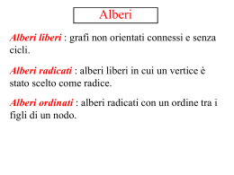
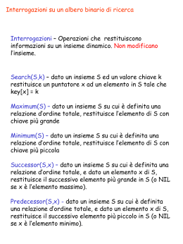
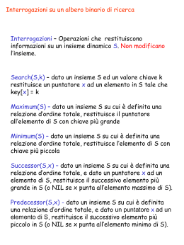
AD 2 LILE 1-1
AIP - Italia
1 LILE
Indicatore di località
Location indicator
BIELLA/Cerrione
Nome dell’ Aeroporto
Aerodrome name
L’indicatore di località non può essere usato nel gruppo Indirizzo dei Location indicator cannot be used in the address component of
Messaggi trasmessi
sulla rete del Servizio fisso delle messages transmitted over Aeronautical Fixed Telecommunication
Network (AFTN)
Telecomunicazioni Aeronautiche (AFTN)
WARNING: Vedi limitazioni di cui alla pagina AD 1.4-1
See limitations detailed in AD 1.4-1
2 DATI AMMINISTRATIVI E GEOGRAFICI DELL’AEROPORTO
AERODROME GEOGRAPHICAL AND ADMINISTRATIVE DATA
1 Coordinate ARP
45°29'45''N 008°06'09''E
2 Direzione e distanza dalla città
4.32 NM SE di Biella
3 Elevazione/Temperatura di riferimento
920 FT / NIL
4 Variazione magnetica/Variazione annuale
1° E (2005.0) / 6'E
5 Autorità amministrativa aeroportuale
ENAC - DA Torino
10072 - Caselle Torinese (TO)
tel +39 011 5678407/5678413 fax +39 011 4704320
e-mail: [email protected]
ARP coordinates
45°29'45''N 008°06'09''E
Direction and distance from city
4.32 NM SE Biella
Elevation/Reference temperature
920 FT / NIL
Magnetic variation/Annual change
1° E (2005.0) / 6'E
Aerodrome administration authority
ENAC - DA Torino
10072 - Caselle Torinese (TO)
tel +39 011 5678407/5678413 fax +39 011 4704320
e-mail: [email protected]
Esercente
Società SACE S.p.A
Via M. Mucrone, 2 - 13882 VERGNASCO (BI)
Tel +39 015 671918/015 2583949 fax +39 015 671989
e-mail: [email protected], [email protected]
Autorità ATS
AFIS in concessione
Tel +39 015 671293 Fax +39 015 671815
6 Tipo di traffico consentito (IFR/VFR)
VFR
7 Note
NIL
Aerodrome operator
Società SACE S.p.A
Via M. Mucrone, 2 - 13882 VERGNASCO (BI)
Tel +39 015 671918/015 2583949 fax +39 015 671989
e-mail: [email protected], [email protected]
ATS authority
Delegated AFIS
Tel +39 015 671293 Fax +39 015 671815
Type of traffic permitted (IFR/VFR)
VFR
Remarks
NIL
3 ORARIO DI SERVIZIO
OPERATIONAL HOURS
1 Amministrazione aeroportuale
0730-SS+30 (0630-1800)
2 Dogana e immigrazione
A richiesta su piano di volo
3 Servizio sanitario
Disponibile con 20’ di preavviso
4 AIS
0730-SS+30 (0630-1800)
5 ARO
ARO di riferimento TORINO/Caselle: H24
6 METEO
METEO di riferimento TORINO/Caselle: H24
7 ATS
0730-SS+30 (0630-1800)
8 Rifornimento
0730-SS+30 (0630-1800)
9 Handling
0730-SS+30 (0630-1800)
10 Servizi di sicurezza
A richiesta su piano di volo
11 De-icing
NIL
12 Note
1)
Dogana e immigrazione: per il traffico extracomunitario vale
quanto segue:
a)
dalle ore 0000 (2300) del MON alle 1530 (1430) del FRI
con 3 ore di preavviso tramite FPL e con preavviso
tramite notifica alla SACE S.p.A. tel +39 015 671293, fax
+39 015 671815
b)
SAT, SUN e HOL con preavviso tramite FPL che deve
essere notificato entro le 1600 (1500) del precedente
giorno lavorativo
c)
spese dogana a carico richiedente
Aerodrome Administration
0730-SS+30 (0630-1800)
Customs and immigration
On request on flight plan
Health and sanitation
Available 20’ PN
AIS
0730-SS+30 (0630-1800)
ARO
Competent ARO TORINO/Caselle: H24
METEO
Competent METEO TORINO/Caselle: H24
ATS
0730-SS+30 (0630-1800)
Fuelling
0730-SS+30 (0630-1800)
Handling
0730-SS+30 (0630-1800)
Security
On request on flight plan
De-icing
NIL
Remarks
1)
Custom and immigration: Extra UE (United Europe) air traffic,
as follows:
a)
from MON HR 0000 (2300) to FRI HR 1530 (1430), with 3
HR PN by FPL and previous notification to SACE S.p.A. tel
+39 015 671293, fax +39 015 671815
b)
SAT, SUN and HOL PN by FPL to be notified within HR
1600 (1500) of previous working day
c)
customs duty to be charged to the applicant
4 SERVIZI DI SUPPORTO ED ATTREZZATURE
HANDLING SERVICES AND FACILITIES
1 Attrezzatura di carico e scarico merci
NIL
Cargo-handling facilities
NIL
ENAV - Roma
17 JUL 2008
(8/08)
AD 2 LILE 1-2
AIP - Italia
2 Tipi di carburante/Olio
JET A1, AVGAS 100LL / NIL
3 Capacità di rifornimento
JET A1: 1 pompa, capacità 15660 litri
JET A1: 1 autobotte, capacità 17000 litri
AVGAS 100LL: 1 pompa, capacità 15660 litri
4 Sistema de-icing
NIL
5 Hangar per aeromobili in transito
1 hangar disponibile previo contatto con SACE SpA
6 Servizio riparazioni per aeromobili in transito
Officina autorizzata Air Support International tel +39 015 2583082/
2583942
7 Note
1)
Sono disponibili TOWBARLESS LEKTRO per movimentazione
aeromobili parcheggiati non frenati e G.P.U.
5 SERVIZI PER I PASSEGGERI
Fuel/Oil types
JET A1, AVGAS 100LL / NIL
Fuelling capacity
JET A1: 1 pump, capacity 15660 litres
JET A1: 1 tank truck, capacity 17000 litres
AVGAS 100LL: 1 pump, capacity 15660 litres
De-icing facilities
NIL
Hangar space for visiting aircraft
1 hangar AVBL prior coordination with SACE SpA
Repair facilities for visiting aircraft
Maintenance: Air Support International tel. +39 015 2583082/
2583942
Remarks
1)
TOWBARLESS LEKTRO for the movement of not braked aircraft
and G.P.U. AVBL
PASSENGER FACILITIES
1 Alberghi
Hotels
In città e in prossimità dell'aeroporto
In town and near the airport
2 Ristoranti
Restaurants
In città ed in prossimità dell'aeroporto
In town and near the airport
3 Trasporti
Transportation
Taxi su richiesta - servizio transfert per gruppi a richiesta previo Taxi O/R - shuttle service for groups on request and prior
contatto con SACE Spa
coordination with SACE Spa
4 Servizio medico
Medical facilities
Ambulanza
Ambulance
5 Banca e ufficio postale
Bank and Post office
NIL
NIL
6 Ufficio turistico
Touristic office
Welcome Point in aerostazione
Welcome Point in the airport
7 Note
Remarks
NIL
NIL
6 SERVIZI ANTINCENDIO E DI SOCCORSO
RESCUE AND FIRE FIGHTING SERVICES
1 Categoria servizio antincendio aeroportuale
CAT 4 ICAO
2 Equipaggiamento per il soccorso
NIL
3 Rimozione aeromobili in difficoltà
Trattore
4 Note
NIL
Aerodrome category for fire fighting
CAT 4 ICAO
Rescue equipment
NIL
Capability for removal of disabled aircraft
Tractor
Remarks
NIL
7 DISPONIBILITA’
PISTE
STAGIONALE
E
SISTEMI
DI
1 Equipaggiamenti di pulitura
NIL
2 Priorità
NIL
3 Note
NIL
PULITURA SEASONAL AVAILABILITY AND CLEARING
Types of clearing equipment
NIL
Clearance priorities
NIL
Remarks
NIL
8 DATI RELATIVI AI PIAZZALI, ALLE VIE DI RULLAGGIO ED APRONS, TAXIWAYS AND CHECK LOCATIONS DATA
ALLE PIAZZOLE PROVA
1 Superficie e resistenza dell’area di stazionamento
Apron
Superficie: ASPH
Resistenza: PCN 18/F/B/W/T
2 Larghezza, superficie e resistenza delle TWY
A
Larghezza: 15 M
Superficie: ASPH
Resistenza: PCN
B
Larghezza: 15 M
Superficie: ASPH
Resistenza: PCN
C
Larghezza: 15 M
Superficie: ASPH
Resistenza: PCN
D
Larghezza: 15 M
Superficie: ASPH
Resistenza: PCN
17 JUL 2008
(8/08)
26/F/A/W/T/
26/F/A/W/T
20/F/A/W/T
26/F/A/W/T
Apron surface and strength
Apron
Surface: ASPH
Strength: PCN 18/F/B/W/T
TWY width, surface and strength
A
Width: 15 M
Surface: ASPH
Strength: PCN 26/F/A/W/T/
B
Width: 15 M
Surface: ASPH
Strength: PCN 26/F/A/W/T
C
Width: 15 M
Surface: ASPH
Strength: PCN 20/F/A/W/T
D
Width: 15 M
Surface: ASPH
Strength: PCN 26/F/A/W/T
ENAV - Roma
AD 2 LILE 1-3
AIP - Italia
3 Localizzazione/Elevazione ACL
ACL location/Elevation
NIL
NIL
4 Punto di controllo VOR/INS
VOR/INS checkpoints
NIL / NIL
NIL / NIL
5 Note
Remarks
NIL
NIL
9 GUIDA AI MOVIMENTI A TERRA E SISTEMI DI CONTROLLO E SURFACE MOVEMENT GUIDANCE AND CONTROL SYSTEM AND
SEGNALAZIONE
MARKINGS
1 Segnale di identificazione stand aeromobili, linee guida per
TWY e sistemi di guida per parcheggio a vista negli stand
degli aeromobili
NIL
2 Illuminazione e segnaletica per RWY e TWY
TWY A, B, C, D sono illuminate
3 Barre d’arresto
Vedi carta AD in vigore
4 Note
NIL
10 OSTACOLI AEROPORTUALI
Use of aircraft stand identification sign, TWY guide lines and
visual docking/parking guidance system of aircraft stands
NIL
RWY and TWY markings and lights
TWY A, B, C, D lighted
Stop bars
See AD chart in force
Remarks
NIL
AERODROME OBSTACLES
Nelle aree di avvicinamento e decollo
In approach and take off areas
Nell’area di circuitazione e all’interno
dell’aerodromo
In circling area and at aerodrome
2
Coordinate
Tipo di ostacolo
Coordinate
Coordinates
Elevazione
Coordinates
Segnaletica e Luci
Obstacle type
Elevation
Marking and Lights
c
a
b
Vedi AOC in vigore
See AOC in force
1
Tipo di ostacolo
Elevazione
Segnaletica e Luci
Obstacle type
Elevation
Markings and Lights
b
RWY e Area
interessata
RWY and Area
affected
a
11 INFORMAZIONI METEOROLOGICHE
Note
Remarks
3
METEOROLOGICAL INFORMATION
1 Ufficio METEO di riferimento
NIL
2 Orario di servizio
NIL
3 Ufficio responsabile preparazione TAF/Periodo di validità
NIL / NIL
4 Tipo di previsione per l’atterraggio/Intervallo di emissione
NIL / NIL
5 Briefing e consultazione fornita
NIL
6 Documentazione di volo/Lingua usata
NIL
7 Carte e documentazione disponibili per consultazione
NIL
9 Enti ATS destinatari delle informazioni
NIL
10 Informazioni climatologiche e informazioni supplementari
NIL
Associated MET office
NIL
Hours of service
NIL
Office responsible for TAF preparation/Period of validity
NIL / NIL
Type of landing forecast/Interval of issuance
NIL / NIL
Briefing and consultation provided
NIL
Flight documentation/Language used
NIL
Charts and other information available for briefing or
consultation
NIL
Supplementary
equipment
available
for
providing
information
NIL
ATS units provided with information
NIL
Climatological information and additional information
NIL
12 CARATTERISTICHE FISICHE DELLE PISTE
RUNWAY PHYSICAL CHARACTERISTICS
NIL
8 Mezzi aggiuntivi disponibili per l’informazione
Designazione
NR RWY
Designation
QFU
Dimensioni RWY
Dimension of RWY
(M)
Resistenza e superficie di
RWY
Strength and surface of
RWY
Coordinate THR
THR coordinates
4
PCN 28/F/A/W/T
ASPH
PCN 28/F/A/W/T
ASPH
5
45°30'03.71''N
008°05'57.40''E
45°29'26.42''N
008°06'20.89''E
1
2
3
16
155°
1320 x 30
34
335°
1320 x 30
Designazione
NR RWY
Designation
1
16
ENAV - Roma
Pendenza di
RWY-SWY
Slope
7
Vedi AOC
See AOC
THR ELEV, MAX TDZ ELEV
della RWY per APCH di
precisione
THR ELEV, MAX TDZ ELEV
of precision APCH RWY
6
920 FT / 920 FT
876 FT / 876 FT
Dimensioni SWY
SWY dimension
(M)
8
Dimensioni CWY
CWY dimension
(M)
9
Dimensioni strip
strip dimension
(M)
10
Dimensioni RESA
RESA dimension
(M)
11
NIL
150 x 150
1440 x 150
90 x 150
08 NOV 2007 (12/07)
AD 2 LILE 1-4
AIP - Italia
Designazione
NR RWY
Designation
1
Pendenza di
RWY-SWY
Slope
7
Vedi AOC
See AOC
34
Dimensioni SWY
SWY dimension
(M)
8
Dimensioni CWY
CWY dimension
(M)
9
Dimensioni strip
strip dimension
(M)
10
Dimensioni RESA
RESA dimension
(M)
11
NIL
150 x 150
1440 x 150
90 x 150
Designazione
NR RWY
Designation
1
OFZ
Obstacle free zone (OFZ)
Note
Remarks
12
16
NIL
34
NIL
13
1) L'area di 90 x 30 M antistante la testata 16 è disponibile per il decollo su richiesta del pilota
The area 90 x 30 M located before RWY head 16 is AVBL for take off on pilot's request
1) L'area di 90 x 30 M antistante la testata 34 è disponibile per il decollo testata 34 è disponibile
per il decollo su richiesta del pilota
The area 90 x 30 M located before RWY head 34 is AVBL for take off on pilot's request
2) DTHR 60 M
13 DISTANZE DICHIARATE
DECLARED DISTANCES
Designazione RWY
RWY designator
1
16
34
TORA
(M)
2
1320
1320
TODA
(M)
3
1470
1470
14 LUCI DI AVVICINAMENTO E LUCI PISTA
RWY
ID
THR
VASIS
2.2
NIL
2.3
NIL
3
G
4.1
NIL
34
SALS
420
LIH
G
NIL
Lunghezza
Length
(M)
5
NIL
12.2
NIL
BORDO PISTA
RWY EDGE
Spaziatura
Colore
Spacing
Colour
(M)
7.3
W
Y
7.4
LIH
LIH
60
60
W
Y
LIH
LIH
RTIL
CGL
Note
Remarks
10
NIL
NIL
11
NIL
NIL
12
NIL
NIL
6.3
6.4
16
NIL
NIL
NIL
NIL
7.1
720
600
34
NIL
NIL
NIL
NIL
720
600
SWY
Lunghezza
Length
(M)
Colore
Colour
9.1
NIL
NIL
9.2
NIL
NIL
8
R
R
4.3
NIL
7.2
60
60
6.2
1
16
34
4.2
NIL
3°
wing bar
lato sinistro
left side
Lunghezza
Length
(M)
6.1
FINE PISTA
RWY END
Colore
Colour
TDZ
Intensità
Intensity
1
RWY
ID
MEHT
(M)
Lunghezza
Length
(M)
2.1
NIL
ASSE CENTRALE PISTA
RCL
Spaziatura
Colore
Spacing
Colour
(M)
PAPI
Colore
Colour
1
16
RWY
ID
LDA
(M)
5
1320
1260
APPROACH AND RUNWAY LIGHTING
AVVICINAMENTO
APPROACH
Lunghezza
Intensità
Length
Intensity
(M)
Tipo
Type
ASDA
(M)
4
1320
1320
Intensità
Intensity
15 ILLUMINAZIONE AGGIUNTIVA, ALIMENTAZIONE SECONDARIA OTHER LIGHTING, SECONDARY POWER SUPPLY
1 Localizzazione ABN/IBN, caratteristiche e orari
Coordinate ABN: 45°29'55''N 008°05'54''E
Caratteristiche: ABN rotante a luci W/G alternate
Orario: 0730-SS+30 (0630-1800)
2 Localizzazione LDI e luci
Localizzazione anemometro e luci
LDI: NIL
Anemometro ad elica:
a 460 M dalla THR RWY 16, 130 M a destra della RCL
3 Illuminazione bordo e asse centrale TWY
See AD chart in force
4 Alimentatore secondario/Tempo di intervento
Disponibile / 20 secondi
5 Note
1)
ABN/IBN location, characteristics and hours of operation
ABN Coordinates: 45°29'55''N 008°05'54''E
Characteristics: ABN revolving W/G alternating lights
Hours: 0730-SS+30 (0630-1800)
LDI location and lights
Anemometer location and lights
LDI: NIL
Propeller anemometer:
at 460 M from THR RWY 16, 130 M rightside RCL
TWY edge and centre line lighting
Vedi carta AD in vigore
Secondary power supply/Switch over time
Available / 20 seconds
Remarks
WDI illuminata posizionata a 460 M dalla THR RWY 34, 130 M a 1)
destra della RCL
08 NOV 2007
(12/07)
Lighted WDI positioned at 460 M from THR RWY 34, 130 M
rightside RCL
ENAV - Roma
AD 2 LILE 1-5
AIP - Italia
16 AREA DI ATTERRAGGIO ELICOTTERI
HELICOPTERS LANDING AREA
1 Posizione
NIL
2 Elevazione
NIL
3 Dimensioni, superficie, resistenza, segnaletica
NIL
4 Orientamento
NIL
5 Distanze dichiarate
NIL
6 Luci
NIL
7 Note
NIL
Position
NIL
Elevation
NIL
Dimensions, surface, strength, marking
NIL
Bearing
NIL
Declared distances
NIL
Lighting
NIL
Remarks
NIL
17 SPAZIO AEREO ATS
ATS AIRSPACE
Designatare e limiti laterali
Designation and lateral limits
Limiti
verticali
Vertical
limits
Classificazione dello
spazio aereo
Airspace
classification
1
2
3
NIL
NIL
G
18 SERVIZI DI COMUNICAZIONE ATS
Nominativo
Call sign
2
Frequenza MHZ
Frequency MHZ
3
NIL
121.500 MHZ
AFIS
Biella INFO
123.050 MHZ
Orario
Operational hours
4
0730-SS+30 (06301800)
0730-SS+30 (06301800)
19 RADIOASSISTENZE ALLA NAVIGAZIONE E ALL’ATTERRAGGIO
FREQ
Orario
Operational
hours
Coordinate
antenna
Antenna site
coordinates
(WGS84)
Elevazione
antenna
DME
Elevation of
DME antenna
2
3
4
5
6
VOR
H24
DME
H24
VOR
45°29'39.2''N
008°06'02.1''E
DME
45°29'39.0''N
008°06'01.7''E
NIL
NIL
BLA
116.10
MHZ
CH 108X
NDB
BLA
350.00
KHZ
H24
45°27'43.9''N
008°07'24.1''E
L
RMG
337.00
KHZ
H24
45°37'42.4''N
008°24'23.6''E
VOR/DME
(1° E-2005.0)
VOR/DME
(1° E-2005.0)
ENAV - Roma
SRN
113.70
MHZ
CH 84X
Note
Remarks
5
6
NIL
1) WI Milano FIR
VOR
H24
DME
H24
Note
Remarks
5
NIL
NIL
RADIO NAVIGATION AND LANDING AIDS
ID
CAT di/of ILS
(VAR ILS/VOR)
1
Altitudine di
transizione
Transition
altitude
ATS COMMUNICATION FACILITIES
Servizio
Service
1
Emergenza
Emergency
Tipo di
radioassistenza
Type of aid
Nominativo
dell’unità ATS
Lingua
ATS unit call sign
Language
4
Biella INFO
EN / IT
VOR
45°38'45.5''N
009°01'18.0''E
DME
45°38'45.5''N
009°01'18.0''E
281 M AMSL
244 M AMSL
Copertura operativa
nominale
Limitazioni
Designated operational
coverage
Limitations
Note
Remarks
7
8
30 NM/25000 FT
limitazioni a/limitations at
30 NM
030°/050° MRA 6000 FT
NIL
050°/230° MRA 4000 FT
230°/260° MRA 10000 FT
260°/030° MRA 18000 FT
25 NM/10000 FT
limitazioni entro/limitations
within 25 NM
030°/250° MRA 10000 FT
250°/030° MRA 16000 FT
1) MAINT:
Primo TUE di ogni
mese/first TUE of
each month 11001300 (1000-1200)
25 NM
Limitazioni/limitations:
1) MAINT:
Secondo FRI di ogni
mese / second FRI
each month: 08000900 (0700-0800)
090°/270° MRA 4000 FT
270°/090° MRA 12000 FT
100 NM/50000 FT
limitazioni entro/limitations
within 10 NM MRA 2000 FT
limitazioni oltre/limitations
beyond
10
NM
entro/
limitations within 20 NM
000°/080° MRA 7500 FT
080°/280° MRA 3000 FT
280°/360° MRA 6000 FT
limitazioni oltre/limitations
beyond
20
NM
entro/
limitations within 40 NM
000°/070° MRA 13000 FT
070°/090° MRA 10000 FT
090°/270° MRA 4000 FT
270°/360° MRA 12000 FT
1) MAINT:
Primo WED di ogni
mese / first WED
each month: 07000830 (0600- 0730)
2) RDL 065:
COV
ridotta
a/
reduced to 80 NM
17 JUL 2008
(8/08)
AD 2 LILE 1-6
AIP - Italia
Tipo di
radioassistenza
Type of aid
ID
FREQ
Orario
Operational
hours
Coordinate
antenna
Antenna site
coordinates
(WGS84)
Elevazione
antenna
DME
Elevation of
DME antenna
Copertura operativa
nominale
Limitazioni
Designated operational
coverage
Limitations
Note
Remarks
2
3
4
5
6
7
8
CAT di/of ILS
(VAR ILS/VOR)
1
VOR/DME
(1° E-2005.0)
114.50
MHZ
CH 92X
TOP
VOR
H24
DME
H24
VOR
44°55'31.5''N
007°51'42.0''E
DME
44°55'31.5''N
007°51'42.0''E
260 M AMSL
1) MAINT:
Primo THU di ogni
mese / first THU
each month: VOR
Altri settori/other sectors:
0700-0800 (060080 NM/60000 FT
0700) DME 0700Settore/Sector S: 200 NM/ 1100 (0600-1000)
60000 FT
Terzo THU di ogni
limitazioni a/limitations at mese / third THU
40 NM
each month: VOR
015°/100° MRA 4000 FT
1300-1400 (1200100°/180° MRA 6000 FT
1300) DME 1300180°/230° MRA 10000 FT
1700 (1200-1600)
230°/340° MRA 15000 FT
340°/015° MRA 10000 FT
2) COV:
ridotta a /reduced
to 80 NM su/on RDL
142
VOR/DME
(1° E-2005.0)
VOG
115.50
MHZ
CH 102X
VOR
H24
DME
H24
VOR
44°57'52.3''N
008°58'12.7''E
DME
44°57'52.3''N
008°58'12.7''E
20 REGOLAMENTI DEL TRAFFICO LOCALE
1 Uso preferenziale delle piste
La pista 34 è la preferenziale
2 Servizio apron
E’ disponibile il servizio di marshalling
3 Norme per l’utilizzo delle vie di rullaggio
NIL
4 Procedure speciali applicabili agli aeromobili in condizioni di
bassa visibilità
NIL
5 Operazioni per l’utilizzo della pista nel tempo strettamente
necessario
NIL
6 Restrizioni locali ai voli
I piloti dei voli VFR che intendono operare nelle vicinanze
dell’aeroporto di Biella Cerrione devono contattare Biella INFO
sull’apposita frequenza prima del sorvolo e/o attraversamento dei
sentieri di partenza e/o avvicinamento o prima di entrare nel circuito
di traffico aeroportuale al fine di ricevere informazioni pertinenti e
disponibili e, i suddetti piloti, dovranno attenersi all’osservanza delle
limitazioni relative alle seguenti zone LID 47 A/B ”Ivrea”, poligoni di
tiro a fuoco “Candelo Masazza”, località Biella (vedi AIP ENR 5.2.1-3)
NOTE:
1) il circuito a sinistra per RWY 34 non è visibile dall’operatore AFIS
2) l’area corto finale e la soglia RWY 16 non sono completamente
visibili dall’operatore AFIS
7 Disposizioni per gli aeromobili dell’aviazione generale
NIL
117 M AMSL
40 NM/25000 FT
limitazioni a/limitations at
1) MAINT:
40 NM
Terzo TUE di ogni
040°/080° MRA 5000 FT
mese / third TUE
080°/100° MRA 9000 FT
each month: 0930100°/170° MRA 11000 FT
1030 (0830-0930)
170°/230° MRA 8000 FT
230°/250° MRA 6000 FT
250°/040° MRA 4000 FT
LOCAL TRAFFIC REGULATIONS
Runway preferential use
Preferential RWY 34
Apron management service
Marshalling service is available
Special rules for taxiway use
NIL
Aircraft special procedures in low visibility conditions
NIL
Special operational practice for minimum RWY occupancy
NIL
Local flight restrictions
Pilots of VFR flights intending to operate in the vicinity of Biella
Cerrione airport are requested to contact Biella information on the
appropriate frequency before overflying and/or crossing departure
and/or approach slopes or before entering the aerodrome traffic
circuit in order to receive pertinent and available information and
shall comply with the restrictions concerning the following areas:
LID 47 A/B “Ivrea”, military firing area “Candelo Masazza”, site
Biella (see AIP ENR 5.2.1-3).
REMARKS:
1) left circuit RWY 34 not in sight of AFIS operator
2) short final area and THR of RWY 16 are not completely visible by
AFIS operator
Provisions for general aviation aircraft
NIL
21 PROCEDURE ANTIRUMORE
NOISE ABATEMENT PROCEDURES
1 Generalità
NIL
2 Uso delle piste
NIL
3 Restrizioni al suolo
NIL
4 Attività addestrativa
NIL
General
NIL
Use of RWY
NIL
Ground restrictions
NIL
Training activity
NIL
22 PROCEDURE DI VOLO
1 Generalità
NIL
2 Procedure per i voli IFR
NIL
3 Procedure radar
NIL
17 JUL 2008
(8/08)
FLIGHT PROCEDURES
General
NIL
Procedures for IFR flights
NIL
Radar procedures
NIL
ENAV - Roma
AD 2 LILE 1-7
AIP - Italia
4 Procedure per i voli VFR
4.1 Informazioni generali
NIL
4.2 Attività di circuito
1)
Circuiti preferenziali ad est della RWY:
a)
virata a destra per RWY 34 max 1500 ft AGL
b)
virata standard per RWY 16 max 1500 ft AGL
2)
Quando l’area militare di poligoni di tiro a fuoco “Candelo
Masazza” (vedi AIP ENR 5.2.1-3) è attiva o, su richiesta del
pilota, il circuito ad ovest della RWY può essere usato:
a)
virata a destra per RWY 16 max 1500 ft AGL
b)
virata standard per RWY 34 max 1500 ft AGL
I circuiti ad ovest della RWY non sono completamente visibili
dall’operatore AFIS.
4.3 Arrivi
NIL
4.4 Partenze
NIL
4.5 Sorvoli
NIL
4.6 VFR Speciale
NIL
4.7 VFR notturno
NIL
4.8 Attività addestrativa
NIL
23 INFORMAZIONI AGGIUNTIVE
NIL
24 CARTE RELATIVE ALL’AEROPORTO DI BIELLA/Cerrione
Procedures for VFR flights
General information
NIL
Circuit activity
1)
Preferential circuits east of RWY:
a)
right turn for RWY 34 max 1500 ft AGL
b)
standard turn for RWY 16 max 1500 ft AGL
2)
When military firing area “Candelo Masazza” (see AIP ENR
5.2.1-3) is active or on pilot’s request, circuit west of RWY
may be used:
a)
right turn for RWY 16 max 1500 ft AGL
b)
standard turn for RWY 34 max 1500 ft AGL
Circuits west of RWY are not completely in sight by AFIS
operator.
Arrivals
NIL
Departures
NIL
Overflying
NIL
Special VFR
NIL
Night VFR
NIL
Training activity
NIL
ADDITIONAL INFORMATION
NIL
CHARTS RELATED TO BIELLA/Cerrione AERODROME
Carte - Charts
Pagine - Pages
Aerodrome Chart
AD 2 LILE 2-1
Aerodrome Obstacle Chart - Type A
AD 2 LILE 3-1
Standard Instrument Arrival Chart (STAR)
AD 2 LILE 4-1
Instrument Approach Chart (IAC) VOR Z RWY 34
AD 2 LILE 5-1
Instrument Approach Chart (IAC) VOR Y RWY 34
AD 2 LILE 5-3
Standard Instrument Departure Chart (SID)
AD 2 LILE 6-1
Aerodrome Obstacle Chart - Type B
Vedi/see GEN 3.2
ENAV - Roma
17 JUL 2008
(8/08)
Intenzionalmente bianca
Intentionally left blank
Scarica